Turnagain Pass RSS

Archives
ARCHIVED - Forecasts expire after 24 hours.
Issued
Mon, January 31st, 2022 - 7:00AM
Expires
Tue, February 1st, 2022 - 7:00AM
Forecaster
Andrew Schauer
Avalanche risk The Bottom Line

The avalanche danger is MODERATE above 1000′. It is possible to trigger an avalanche 2′ deep or deeper on lingering wind slabs that formed during last week’s storm. Approach steep slopes with caution, and avoid terrain that has been recently wind loaded. The most likely places to find unstable snow will be near ridgelines, on convex rolls, and in gullies.

The danger is LOW below 1000′, where a thick crust on the surface will make avalanches unlikely.

Special Announcements

Forecaster Chat # 2: Join us virtually this Thursday evening, Feb. 3, for an interview with US Air Force Major Kevin Kelly of the Alaska Rescue Coordination Center. We’ll get his behind-the-scenes perspective of the role AKRCC plays in backcountry search and rescue missions, and try to share some tips on how to help facilitate an effective rescue should something go sideways in the backcountry. Stay tuned for more details and registration info.

Mon, January 31st, 2022
Alpine
Above 2,500'
2 - Moderate
Avalanche risk
Treeline
1,000'-2,500'
2 - Moderate
Avalanche risk
Below Treeline
Below 1,000'
1 - Low
Avalanche risk
0 - No Rating
1 - Low
2 - Moderate
3 - Considerable
4 - High
5 - Extreme
Avalanche risk Avalanche risk Avalanche risk Avalanche risk Avalanche risk
Travel Advice Generally safe avalanche conditions. Watch for unstable snow on isolated terrain features. Heightened avalanche conditions on specific terrain features. Evaluate snow and terrain carefully; identify features of concern. Dangerous avalanche conditions. Careful snowpack evaluation, cautious route-finding, and conservative decision-making essential. Very dangerous avalanche conditions. Travel in avalanche terrain not recommended. Extraordinarily dangerous avalanche conditions. Avoid all avalanche terrain.
Likelihood of Avalanches Natural and human-triggered avalanches unlikely. Natural avalanches unlikely; human-triggered avalanches possible. Natural avalanches possible; human-triggered avalanches likely. Natural avalanches likely; human-triggered avalanches very likely. Natural and human-triggered avalanches certain.
Avalanche Size and Distribution Small avalanches in isolated areas or extreme terrain. Small avalanches in specific areas; or large avalanches in isolated areas. Small avalanches in many areas; or large avalanches in specific areas; or very large avalanches in isolated areas. Large avalanches in many areas; or very large avalanches in specific areas. Very large avalanches in many areas.
Recent Avalanches

Girdwood: Skiers in the Girdwood Valley noted multiple loose snow avalanches that were triggered by rime falling off rocks in the alpine. They turned around when one avalanche released close to the slope they were ascending. Nobody was caught in the avalanche.

Turnagain Pass: A skier triggered an avalanche on peak 4940 on the south end of Seattle Ridge. The skier that triggered the avalanche was not caught in the slide. The avalanche was roughly 2′ deep, 350′ wide and ran 500 vertical feet. It appears the avalanche failed on the interface between new and old snow. The skier was the second person of the group to descend, and initially triggered a smaller avalanche which ran roughly 100′ before propagating wider. More details in this observation.

Crown of a skier-triggered avalanche on a W aspect on peak 4940 at the south end of Seattle Ridge. Nobody was caught in the avalanche. Photo: Mike Records. 01.30.2022


Avalanche Problem 1
  • Wind Slabs
    Wind Slabs
  • Certain
    Very Likely
    Likely
    Possible
    Unlikely
    Likelihood
  • Historic (D4-5)
    Very Large (D3)
    Large (D2)
    Small (D1)
    Size
Wind Slabs
Wind Slab avalanches are the release of a cohesive layer of snow (a slab) formed by the wind. Wind typically transports snow from the upwind sides of terrain features and deposits snow on the downwind side. Wind slabs are often smooth and rounded and sometimes sound hollow, and can range from soft to hard. Wind slabs that form over a persistent weak layer (surface hoar, depth hoar, or near-surface facets) may be termed Persistent Slabs or may develop into Persistent Slabs.

Likelihood of Avalanches
Terms such as "unlikely", "likely", and "certain" are used to define the scale, with the chance of triggering or observing avalanches increasing as we move up the scale. For our purposes, "Unlikely" means that few avalanches could be triggered in avalanche terrain and natural avalanches are not expected. "Certain" means that humans will be able to trigger avalanches on many slopes, and natural avalanches are expected.

Size of Avalanches
Avalanche size is defined by the largest potential avalanche, or expected range of sizes related to the problem in question. Assigned size is a qualitative estimate based on the destructive classification system and requires specialists to estimate the harm avalanches may cause to hypothetical objects located in the avalanche track (AAA 2016, CAA 2014). Under this schema, "Small" avalanches are not large enough to bury humans and are relatively harmless unless they carry people over cliffs or through trees or rocks. Moving up the scale, avalanches become "Large" enough to bury, injure, or kill people. "Very Large" avalanches may bury or destroy vehicles or houses, and "Historic" avalanches are massive events capable of altering the landscape.

Signal Word Size (D scale) Simple Descriptor
Small 1 Unlikely to bury a person
Large 2 Can bury a person
Very Large 3 Can destroy a house
Historic 4 & 5 Can destroy part or all of a village
More info at Avalanche.org

Don’t let the calm conditions lull you into complacency- lingering wind slabs remain our primary concern today. The storm from the end of last week is taking longer than usual to heal, as evidenced by the skier-triggered avalanche on peak 4940 yesterday (details), and multiple skier and snowmachine triggered avalanches on Seattle Ridge on Saturday (details). Most, but not all, of this activity seems to be associated with a brittle crust that formed early last week and was covered by low-density stellars (snowflakes). This layer was highly reactive during the middle of the storm, with widespread natural activity Thursday into Friday. It is becoming more stubborn as we move further out from the last storm event, but today it will still be possible to trigger an avalanche 2′ deep or deeper, especially on slopes that were wind loaded during or immediately following the storm.

The limited data we have from snowpits is giving us mixed results. I found propagating (unstable) results at the crown of a mid-storm avalanche on Saturday. Multiple other pits on Tincan, Eddie’s, Pete’s South, and Squirrel Flats did not propagate, which indicates this layer is slowly healing. Today it will be important to weigh the handful of stable pit results (subtle indicators of improving stability) against the flurry of recent human-triggered avalanches (giant blinking red warning signs of instability), and choose your terrain carefully. Avoid traveling on steep, wind-loaded slopes, where you have the highest likelihood of triggering an avalanche. The most problematic terrain will be near ridgelines, below convex rolls, and in gullies. Keep an eye out for red flags like shooting cracks, collapsing, and other fresh avalanche activity. Also, keep in mind that several of these avalanches involved people who were the second or third set of tracks on a slope.

Persistent Slab: It is becoming increasingly difficult to find unstable clues with the facets associated with the New Year’s crust. We suspect there are isolated slopes where this may still be an issue, with the most likely places being steep, unsupported slopes at upper elevations with thinner snow. The last known activity on this weak layer was the skier-triggered avalanche on the north side of Tincan Proper 11 days ago.

Cornices: Cornices have grown large and dangerous. There were multiple cornice failures during last week’s storm, and they will easily fail under the weight of a person. Be sure to give them plenty of space if you are traveling near ridgelines today.

Dry Loose Avalanches: It will be easy to trigger dry loose avalanches (sluffs) in steep terrain that has not been hit by the wind. These are unlikely to bury a person, but they can have serious consequences if they carry you through terrain traps like rocks, trees or cliffs.

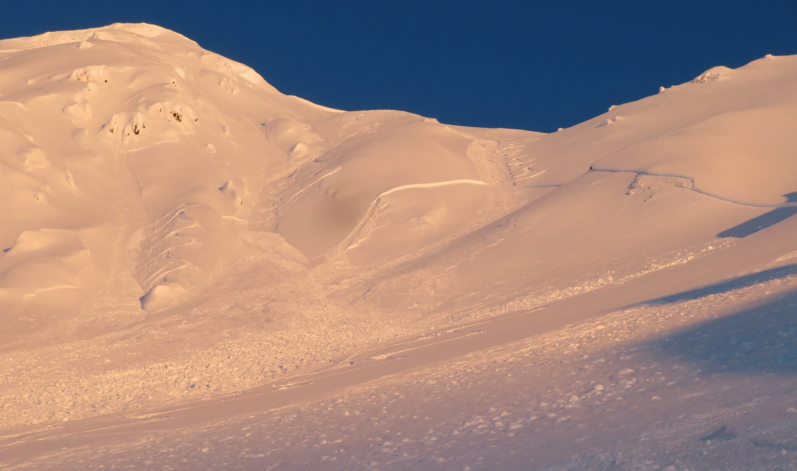
Skier-triggered avalanche in motion on peak 4940 yesterday. Photo: Mike Records. 01.31.2022


Weather
Mon, January 31st, 2022

Yesterday: The clouds hung in thicker than expected near Girdwood and Turnagain Pass, and it seems the only people who saw the sun had to put in some work to poke up above the clouds. High temperatures were in the upper teens to low 20’s F, with overnight lows in the mid teens. Winds were calm with light gusts from varying directions. No precipitation was recorded.

Today: A lingering valley fog will be thickest near the Turnagain Arm, but is looking to be a thinner layer than what we saw yesterday. Visibility should improve during the day, with partly cloudy skies breaking up through the day. We are looking at another day of calm to light breezes, out of the northeast near Girdwood and the east/southeast at Turnagain Pass. High temperatures are expected in the upper 20’s F, and no precipitation is expected today.

Tomorrow: Cloud cover will increase tonight, with a chance for 2-4″ snow tomorrow. Easterly winds are expected to ramp up to 15-30 mph with gusts of 30-40 mph during the day. Temperatures are expected to stay in the low 20’s F with snow to sea level.

PRECIPITATION 24-hour data (6am – 6am)

Temp Avg (F) Snow (in) Water (in) Snow Depth (in)
Center Ridge (1880′) 18 0 0 92
Summit Lake (1400′) 16 0 0 33
Alyeska Mid (1700′) 19 0 0 N/A

RIDGETOP 24-hour data (6am – 6am)

Temp Avg (F) Wind Dir Wind Avg (mph) Wind Gust (mph)
Sunburst (3812′) 17 W 3 15
Seattle Ridge (2400′) 13 N* 1* 6*

*No wind data after 6 p.m. yesterday

Observations
Recent Observations for Turnagain Pass
Date Region Location
04/16/24 Turnagain Observation: Cornbiscuit
04/15/24 Turnagain Observation: Taylor Pass
04/15/24 Turnagain Observation: Seward Highway – Tern Lake to Portage
04/14/24 Turnagain Observation: Sunburst
04/14/24 Turnagain Observation: Turnagain Pass Snomo
04/13/24 Turnagain Observation: Spokane Creek
04/11/24 Turnagain Observation: Tincan
04/10/24 Turnagain Avalanche: Seattle Ridge
04/10/24 Turnagain Observation: Cornbiscuit South Face
04/10/24 Turnagain Avalanche: Tincan
Riding Areas

The riding areas page has moved. Please click here & update your bookmarks.


Subscribe to Turnagain Pass
Avalanche Forecast by Email

This is a general backcountry avalanche advisory issued for Turnagain Arm with Turnagain Pass as the core advisory area. This advisory does not apply to highways, railroads or operating ski areas.