Turnagain Pass Avalanche Forecast RSS

Archives
ARCHIVED FORECAST - All forecasts expire after 24 hours from the posting date/time.
Issued
Wed, January 2nd, 2019 - 7:00AM
Expires
Thu, January 3rd, 2019 - 7:00AM
Forecaster
Heather Thamm
Avalanche risk The Bottom Line

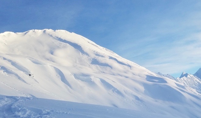
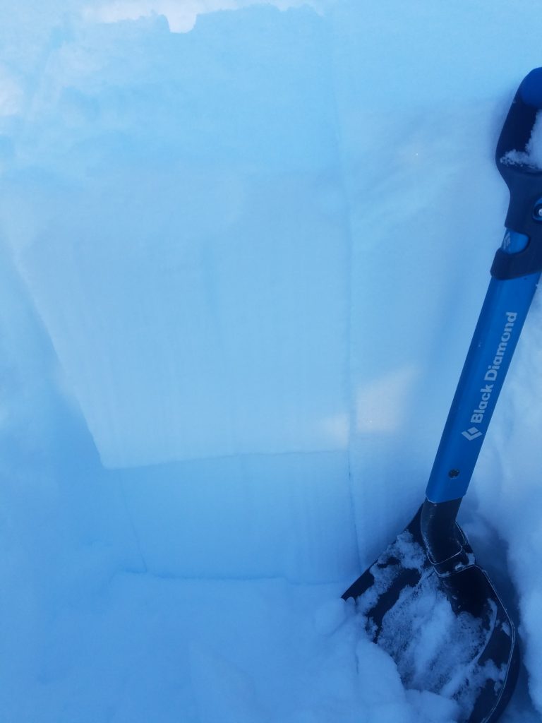
The avalanche danger is CONSIDERABLE above 1000′ where triggering a slab 2-4′ thick is likely on slopes steeper than 35 degrees. Give cornices a wide berth and avoid being under glide cracks. Natural glide avalanches are possible today and could release without warning. Cautious route-finding and conservative decision making are essential.

A  MODERATE  avalanche danger exists below 1000′ where triggering wet loose snow is possible in Portage Valley. This problem will become unlikely if cooling temperatures create a surface crust.

SUMMIT LAKE / JOHNSON PASS / LYNX DRAINAGE:    South of Turnagain Pass, keep in mind old buried weak layers exist and there is potential for triggering a large slab avalanche that breaks near the ground.

Special Announcements
  • Be aware of dangerous avalanche conditions in the Anchorage Front Range/Chugach State park. Several avalanches have been reported over the last few days. Click HERE for details.
  • Parking may be difficult along Turnagain Pass. Please be aware of parking safely and avoid blocking unplowed lots as DOT crews work to clear roads and parking areas.
Thanks to our sponsors!
Wed, January 2nd, 2019
Alpine
Above 2,500'
Considerable (3)
Avalanche risk
Treeline
1,000'-2,500'
Considerable (3)
Avalanche risk
Below Treeline
Below 1,000'
Moderate (2)
Avalanche risk
Alpine
Above 2,500'
Avalanche risk
Considerable (3)
Treeline
1,000'-2,500'
Avalanche risk
Considerable (3)
Below Treeline
Below 1,000'
Avalanche risk
Moderate (2)
Danger Scale:
No Rating (0)
Low (1)
Moderate (2)
Considerable (3)
High (4)
Extreme (5)
Avalanche Problem 1
  • Storm Slabs
    Storm Slabs
  • Almost Certain
    Very Likely
    Likely
    Possible
    Unlikely
    Likelihood
  • Historic (D4-5)
    Very Large (D3)
    Large (D2)
    Small (D1)
    Size
Storm Slabs
Storm Slab avalanches are the release of a cohesive layer (a slab) of new snow that breaks within new snow or on the old snow surface. Storm-slabs typically last between a few hours and few days (following snowfall). Storm-slabs that form over a persistent weak layer (surface hoar, depth hoar, or near-surface facets) may be termed Persistent Slabs or may develop into Persistent Slabs.

Likelihood of Avalanches
Terms such as "unlikely", "likely", and "certain" are used to define the scale, with the chance of triggering or observing avalanches increasing as we move up the scale. For our purposes, "Unlikely" means that few avalanches could be triggered in avalanche terrain and natural avalanches are not expected. "Certain" means that humans will be able to trigger avalanches on many slopes, and natural avalanches are expected.

Size of Avalanches
Avalanche size is defined by the largest potential avalanche, or expected range of sizes related to the problem in question. Assigned size is a qualitative estimate based on the destructive classification system and requires specialists to estimate the harm avalanches may cause to hypothetical objects located in the avalanche track (AAA 2016, CAA 2014). Under this schema, "Small" avalanches are not large enough to bury humans and are relatively harmless unless they carry people over cliffs or through trees or rocks. Moving up the scale, avalanches become "Large" enough to bury, injure, or kill people. "Very Large" avalanches may bury or destroy vehicles or houses, and "Historic" avalanches are massive events capable of altering the landscape.

Signal Word Size (D scale) Simple Descriptor
Small 1 Unlikely to bury a person
Large 2 Can bury a person
Very Large 3 Can destroy a house
Historic 4 & 5 Can destroy part or all of a village
More info at Avalanche.org

Very strong winds and 3+’ of new snow over the last three days has created a variety of storm related avalanche problems. Wind slabs may range from 1-4+’ thick on leeward and cross loaded features and may be located further down slope than expected. Feel for denser snow on top of weaker snow and be wary of pillowed or hard supportable snow that rolls into steeper terrain. In places where storm slabs may be less wind affected, this snow may also be upside-down with denser snow on top of weaker snow. Surface hoar from last week was buried under this new storm snow and its unknown how these persistent weak layers are adjusting. The size of an avalanche will depend on the size of the terrain, the larger and more connected the slope the more potential for a larger avalanche. Obvious signs like whumpfing and cracking may or may not be present until it’s too late. Remember its only been 24 hours since 70+ mph winds and heavy precipitation were falling. This is your first red flag of the day. 

Storm totals (6am Dec.31 – 6am Jan.2)

  • Turnagain Pass: 25” (2.4” SWE)
  • Summit Lake: 12” (1.0” SWE)
  • Girdwood (Alyeska Midway): 27” (2.3” SWE)

CORNICES: High winds and blowing snow will have added to already large cornices. These may be very sensitive, and a cornice fall could trigger a large avalanche on the slope below. Remember these can break further back than expected.  

 Cross loading and some natural storm triggered slabs on specific terrain features was observed in between storms on Monday at Tincan. 


Buried surface hoar found in a pit on Monday was 14″ below the surface. Expect this layer to be at 2-4′ below the surface in some places.  

Avalanche Problem 2
  • Glide Avalanches
    Glide Avalanches
  • Almost Certain
    Very Likely
    Likely
    Possible
    Unlikely
    Likelihood
  • Historic (D4-5)
    Very Large (D3)
    Large (D2)
    Small (D1)
    Size
Glide Avalanches
Glide Avalanches are the release of the entire snow cover as a result of gliding over the ground. Glide avalanches can be composed of wet, moist, or almost entirely dry snow. They typically occur in very specific paths, where the slope is steep enough and the ground surface is relatively smooth. They are often proceeded by full depth cracks (glide cracks), though the time between the appearance of a crack and an avalanche can vary between seconds and months. Glide avalanches are unlikely to be triggered by a person, are nearly impossible to forecast, and thus pose a hazard that is extremely difficult to manage.

Likelihood of Avalanches
Terms such as "unlikely", "likely", and "certain" are used to define the scale, with the chance of triggering or observing avalanches increasing as we move up the scale. For our purposes, "Unlikely" means that few avalanches could be triggered in avalanche terrain and natural avalanches are not expected. "Certain" means that humans will be able to trigger avalanches on many slopes, and natural avalanches are expected.

Size of Avalanches
Avalanche size is defined by the largest potential avalanche, or expected range of sizes related to the problem in question. Assigned size is a qualitative estimate based on the destructive classification system and requires specialists to estimate the harm avalanches may cause to hypothetical objects located in the avalanche track (AAA 2016, CAA 2014). Under this schema, "Small" avalanches are not large enough to bury humans and are relatively harmless unless they carry people over cliffs or through trees or rocks. Moving up the scale, avalanches become "Large" enough to bury, injure, or kill people. "Very Large" avalanches may bury or destroy vehicles or houses, and "Historic" avalanches are massive events capable of altering the landscape.

Signal Word Size (D scale) Simple Descriptor
Small 1 Unlikely to bury a person
Large 2 Can bury a person
Very Large 3 Can destroy a house
Historic 4 & 5 Can destroy part or all of a village
More info at Avalanche.org

Under all this new snow are hidden glide cracks. They are looming over popular ski and snowmachine terrain and may be tricky to identify with new snow covering them. Several glide cracks have avalanched this week and it’s possible more will release in the coming days. The best way to manage this problem is to avoid being under slopes with cracks opening up. They can release at any time and are not typically associated with human triggers. Glide avalanche have occurred in Lynx Creek, on Lipps, and Seattle Ridge  this week.

Most recent known glide avalanche was seen on Monday on an East facing slope of Seattle Ridge near Bertha Creek. 

Additional Concern
  • Persistent Slabs
    Persistent Slabs
Persistent Slabs
Persistent Slab avalanches are the release of a cohesive layer of snow (a slab) in the middle to upper snowpack, when the bond to an underlying persistent weak layer breaks. Persistent layers include: surface hoar, depth hoar, near-surface facets, or faceted snow. Persistent weak layers can continue to produce avalanches for days, weeks or even months, making them especially dangerous and tricky. As additional snow and wind events build a thicker slab on top of the persistent weak layer, this avalanche problem may develop into a Deep Persistent Slab.
More info at Avalanche.org

South of Turnagain:  A shallow and poor snowpack structure exists in the Summit Lake zone. Buried weak layers of facets associated with crusts sit near the base of the snowpack. An observation from Lynx Creek on Friday also found a reactive layer of facets mid pack and this area is also suspect. Summit Lake did receive strong winds the last few days as well as a foot of new snow at road level, likely more in the alpine. Do not forget the possibility of triggering a larger avalanche that could release near the ground. Check out the Summit observations HERE for the most current information. 

Weather
Wed, January 2nd, 2019

Yesterday: Strong Easterly winds decreased from 50mph yesterday morning to 15-30mph for the remainder of the day. A wintery mix of rain and snow was observed along Turnagain Pass with rain/snowline around 900′. Several additional inches of snow fell yesterday following an intense period of heavy snow and rain before 6am. Temperatures hovered around 32F at 1000′ and ridgetops were in the mid 20F’s.

Today: Skies are expected to be mostly cloudy with scattered snow showers and a few inches of new snow possible. Rain/snow line is expected to drop in elevation from 500′ this morning to sea level by this afternoon with cooling temperatures. Expect temperatures near sea level to drop into the mid 20Fs overnight and teens in the mid elevations. Ridgetop winds from the East will be moderate 10-25mph transitioning to light from the Southwest later in the day.

Tomorrow: A cooling trend is expected tomorrow as high pressure moves into our region through the end of the week. Expect clearing skies and temperatures to continue to drop into the single digits.

*Seattle Ridge weather station was heavily rimed and the anemometer (wind sensor) was destroyed.    

PRECIPITATION 24-hour data (6am – 6am)

  Temp Avg (F) Snow (in) Water (in) Snow Depth (in)
Center Ridge (1880′) 31   1   0.1   66  
Summit Lake (1400′) 33   5   0.4   22  
Alyeska Mid (1700′) 31   1   0.16   51  

RIDGETOP 24-hour data (6am – 6am)

  Temp Avg (F) Wind Dir Wind Avg (mph) Wind Gust (mph)
Sunburst (3812′) 23   ENE   17   74  
Seattle Ridge (2400′) 28   *N/A   *N/A     *N/A    
Observations
Recent Observations for Turnagain Pass
Date Region Location
05/22/23 Turnagain Avalanche: Tincan
05/12/23 Turnagain Avalanche: Tincan, Sunburst, Magnum, Cornbiscuit
05/07/23 Turnagain Observation: Tincan – Bear Tracks
05/05/23 Turnagain Observation: Seattle Ridge
05/02/23 Turnagain Observation: Cornbiscuit
05/02/23 Turnagain Observation: Seward Hwy Turnagain Pass
04/30/23 Turnagain Observation: Magnum
04/29/23 Turnagain Observation: Tincan
04/28/23 Turnagain Avalanche: Taylor Pass/Pastoral
04/28/23 Turnagain Avalanche: Tincan
Riding Areas
Updated Thu, June 01st, 2023

Status of riding areas across the Chugach NF is managed by the Glacier and Seward Ranger Districts, not avalanche center staff. Riding area information is posted as a public service to our users and updated based on snow depth and snow density to prevent resource damage at trailhead locations. Riding area questions contact: mailroom_r10_chugach@fs.fed.us

Area Status Weather & Riding Conditions
Glacier District
Johnson Pass
Closed
Closed May 15.
Placer River
Closed
Closed May 15.
Skookum Drainage
Closed
Will close to motorized use on April 1, 2023 per the National Forest Plan.
Turnagain Pass
Closed
Will close on June 1.
Twentymile
Closed
Scheduled closure May 1.
Seward District
Carter Lake
Closed
Scheduled closure May 1.
Lost Lake Trail
Closed
Scheduled closure May 1.
Primrose Trail
Closed
Scheduled closure May 1.
Resurrection Pass Trail
Closed
Closed to motorized use for the 2022/23 winter season per Forest Plan. Open next season.
Snug Harbor
Closed
Extended opening until May 15.
South Fork Snow River Corridor
Closed
Scheduled closure May 1.
Summit Lake
Closed
Scheduled closure May 1.

Subscribe to Turnagain Pass
Avalanche Forecast by Email

This is a general backcountry avalanche advisory issued for Turnagain Arm with Turnagain Pass as the core advisory area. This advisory does not apply to highways, railroads or operating ski areas.