Turnagain Pass Avalanche Forecast RSS

Archives
ARCHIVED FORECAST - All forecasts expire after 24 hours from the posting date/time.
Issued
Mon, March 5th, 2018 - 7:00AM
Expires
Tue, March 6th, 2018 - 7:00AM
Forecaster
Wendy Wagner
Avalanche risk The Bottom Line

The avalanche danger remains  MODERATE  above 1000′ on all aspects. Old wind slabs, up to a foot thick and sitting on weak snow, will be possible to trigger along ridgelines and in cross-loaded gullies. A larger slab avalanche (up to 2′ or more thick) that breaks in weak layers deeper in the snowpack also remains possible above 1,000′.  

Special Announcements

Human triggered avalanches continue to be reported region-wide, one at  Hatcher Pass  and another  in  the  Western Chugach (Hiland Road)  occurred yesterday. Snow last week followed by strong wind increased the avalanche conditions, which may continue to linger in many areas of Southcentral, Alaska.

Thanks to our sponsors!
Mon, March 5th, 2018
Alpine
Above 2,500'
Moderate (2)
Avalanche risk
Treeline
1,000'-2,500'
Moderate (2)
Avalanche risk
Below Treeline
Below 1,000'
Low (1)
Avalanche risk
Alpine
Above 2,500'
Avalanche risk
Moderate (2)
Treeline
1,000'-2,500'
Avalanche risk
Moderate (2)
Below Treeline
Below 1,000'
Avalanche risk
Low (1)
Danger Scale:
No Rating (0)
Low (1)
Moderate (2)
Considerable (3)
High (4)
Extreme (5)
Avalanche Problem 1
  • Persistent Slabs
    Persistent Slabs
  • Almost Certain
    Very Likely
    Likely
    Possible
    Unlikely
    Likelihood
  • Historic (D4-5)
    Very Large (D3)
    Large (D2)
    Small (D1)
    Size
Persistent Slabs
Persistent Slab avalanches are the release of a cohesive layer of snow (a slab) in the middle to upper snowpack, when the bond to an underlying persistent weak layer breaks. Persistent layers include: surface hoar, depth hoar, near-surface facets, or faceted snow. Persistent weak layers can continue to produce avalanches for days, weeks or even months, making them especially dangerous and tricky. As additional snow and wind events build a thicker slab on top of the persistent weak layer, this avalanche problem may develop into a Deep Persistent Slab.

Likelihood of Avalanches
Terms such as "unlikely", "likely", and "certain" are used to define the scale, with the chance of triggering or observing avalanches increasing as we move up the scale. For our purposes, "Unlikely" means that few avalanches could be triggered in avalanche terrain and natural avalanches are not expected. "Certain" means that humans will be able to trigger avalanches on many slopes, and natural avalanches are expected.

Size of Avalanches
Avalanche size is defined by the largest potential avalanche, or expected range of sizes related to the problem in question. Assigned size is a qualitative estimate based on the destructive classification system and requires specialists to estimate the harm avalanches may cause to hypothetical objects located in the avalanche track (AAA 2016, CAA 2014). Under this schema, "Small" avalanches are not large enough to bury humans and are relatively harmless unless they carry people over cliffs or through trees or rocks. Moving up the scale, avalanches become "Large" enough to bury, injure, or kill people. "Very Large" avalanches may bury or destroy vehicles or houses, and "Historic" avalanches are massive events capable of altering the landscape.

Signal Word Size (D scale) Simple Descriptor
Small 1 Unlikely to bury a person
Large 2 Can bury a person
Very Large 3 Can destroy a house
Historic 4 & 5 Can destroy part or all of a village
More info at Avalanche.org

After a month with very little precipitation, weather models are showing potential for a snowy week ahead of us. This is good news for powder hungry folks, but we can’t forget about our current state of the snowpack. As we have been discussing for some time, there are several weak layers in the pack that continue to show signs of reactivity. Hard wind slabs formed by last week’s wind event are, in some cases, overlying these buried weak layers. A human triggered avalanche in the Summit Lake area was proof of this last week. Hence, finding and triggering a slab avalanche remains a concern. 

Persistent slabs:  Buried 1-2 feet deep are facets sitting on a crust at the mid-elevations and 1-3′ deep is a buried surface hoar/facet combo at the higher elevations. The mid-elevation faceted layer seems to be the culprit for many reported ‘whumpfs’/collapses lately and is the layer responsible for the Summit Lake avalanche. Although the heart of Turnagain Pass has these layers, they are more pronounced and developed on the Southern end of Turnagain Pass and in Summit Lake where the snowpack is shallower. Areas to the North, such as Crow Pass, could also be suspect along with those that have not seen much traffic this season. Until we receive a significant load (hopefully this week), triggering these layers are becoming more and more stubborn with time. Continuing to use safe travel protocol and assessing consequences if a slab does release will be key in choosing terrain. The snowpack we have now will likely let us get away with a lot – but probably not everything. 
 

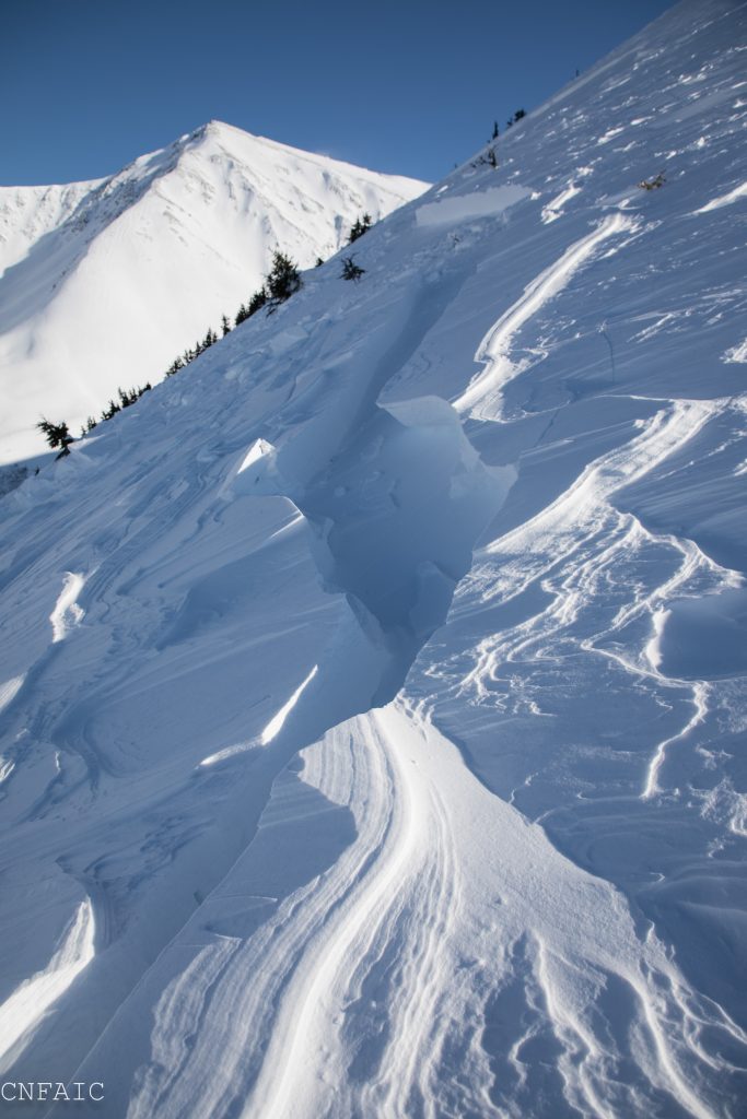
Hard wind slab on faceted snow – Summit Lake/Tenderfoot avalanche that was human triggered last Tuesday (2/27).


Valley fog up to 2,500′ limited visibility along some mid-elevations yesterday. 


Weather
Mon, March 5th, 2018

Partly to mostly sunny skies were found above thick valley fog yesterday; fog lingered late in the day and up to 2,500′. Ridgetop winds were light (5-10mph) from the West and North. Temperatures stayed cool, in the teens along ridgetops, but warmed up in most valley bottoms to ~30F.

Today, Monday, we can expect mostly cloudy skies with a few snow flurries in the afternoon. Only a trace of accumulation is expected. Ridgetop winds will stay light from the Northwest (5-10mph). Temperatures plummeted to the single digits last night in valley bottoms and should bounce back to the 20’sF today. Along the ridgelines, temperatures will remain in the teens.

For tomorrow, Tuesday, cloudy skies and increasing  Southeast winds will be over the area as a quick moving front moves through. Snowfall is expected Tuesday night. This flow direction is not ideal for Turnagain but we could see up to 6 inches. A series of storms will follow Tuesday night’s event, the next system moving in Thursday/Friday. Stay tuned!

PRECIPITATION 24-hour data (6am – 6am)

  Temp Avg (F) Snow (in) Water (in) Snow Depth (in)
Center Ridge (1880′) 22   0   0   67  
Summit Lake (1400′) 14   0   0   28  
Alyeska Mid (1700′) 18   0   0   60  

RIDGETOP 24-hour data (6am – 6am)

  Temp Avg (F) Wind Dir Wind Avg (mph) Wind Gust (mph)
Sunburst (3812′) 16   W   7   17  
Seattle Ridge (2400′) 18   N   5   11  
Observations
Recent Observations for Turnagain Pass
Date Region Location
05/22/23 Turnagain Avalanche: Tincan
05/12/23 Turnagain Avalanche: Tincan, Sunburst, Magnum, Cornbiscuit
05/07/23 Turnagain Observation: Tincan – Bear Tracks
05/05/23 Turnagain Observation: Seattle Ridge
05/02/23 Turnagain Observation: Cornbiscuit
05/02/23 Turnagain Observation: Seward Hwy Turnagain Pass
04/30/23 Turnagain Observation: Magnum
04/29/23 Turnagain Observation: Tincan
04/28/23 Turnagain Avalanche: Taylor Pass/Pastoral
04/28/23 Turnagain Avalanche: Tincan
Riding Areas
Updated Thu, June 01st, 2023

Status of riding areas across the Chugach NF is managed by the Glacier and Seward Ranger Districts, not avalanche center staff. Riding area information is posted as a public service to our users and updated based on snow depth and snow density to prevent resource damage at trailhead locations. Riding area questions contact: mailroom_r10_chugach@fs.fed.us

Area Status Weather & Riding Conditions
Glacier District
Johnson Pass
Closed
Closed May 15.
Placer River
Closed
Closed May 15.
Skookum Drainage
Closed
Will close to motorized use on April 1, 2023 per the National Forest Plan.
Turnagain Pass
Closed
Will close on June 1.
Twentymile
Closed
Scheduled closure May 1.
Seward District
Carter Lake
Closed
Scheduled closure May 1.
Lost Lake Trail
Closed
Scheduled closure May 1.
Primrose Trail
Closed
Scheduled closure May 1.
Resurrection Pass Trail
Closed
Closed to motorized use for the 2022/23 winter season per Forest Plan. Open next season.
Snug Harbor
Closed
Extended opening until May 15.
South Fork Snow River Corridor
Closed
Scheduled closure May 1.
Summit Lake
Closed
Scheduled closure May 1.

Subscribe to Turnagain Pass
Avalanche Forecast by Email

This is a general backcountry avalanche advisory issued for Turnagain Arm with Turnagain Pass as the core advisory area. This advisory does not apply to highways, railroads or operating ski areas.