Turnagain Pass RSS

Archives
ARCHIVED - Forecasts expire after 24 hours.
Issued
Thu, January 28th, 2016 - 7:00AM
Expires
Fri, January 29th, 2016 - 7:00AM
Forecaster
Heather Thamm
Avalanche risk The Bottom Line

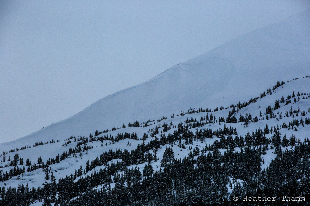
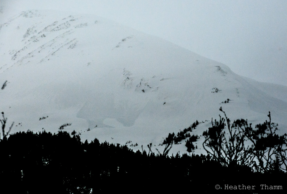
A HIGH avalanche danger exists in the Alpine where a person could trigger a large and destructive avalanche in Turnagain Pass and Girdwood. Today’s elevated danger is based on our travel advice: Travel in Avalanche Terrain is Not Recommended. A CONSIDERABLE avalanche danger is present below 2500′ where the snowpack is wet and saturated and triggering a wet loose avalanche on a steep slope or in a terrain trap will have high consequences. Below treeline a MODERATE danger exists where a wet avalanche from above is possible.

Elevated caution and careful snowpack assessment is recommended for Summit Lake where strong winds and new snow have added stress to a thin snowpack. Click HERE to read the most current Summit Lake Summary and HERE for an observation from yesterday.  

Special Announcements

State of Alaska  Department of Transportation & Public Facilities  Avalanche Closure Notification:  There will be intermittent traffic delays today on the Seward Highway for avalanche hazard reduction work between Girdwood and Portage near mileposts 89 to 83.  Motorists should also expect delays on Portage Glacier Road near mileposts 3 to 5.  Delays of up to 45 minutes between  10:00 AM and 3:00 PM  should be expected.

Thu, January 28th, 2016
Alpine
Above 2,500'
4 - High
Avalanche risk
Treeline
1,000'-2,500'
3 - Considerable
Avalanche risk
Below Treeline
Below 1,000'
2 - Moderate
Avalanche risk
0 - No Rating
1 - Low
2 - Moderate
3 - Considerable
4 - High
5 - Extreme
Avalanche risk Avalanche risk Avalanche risk Avalanche risk Avalanche risk
Travel Advice Generally safe avalanche conditions. Watch for unstable snow on isolated terrain features. Heightened avalanche conditions on specific terrain features. Evaluate snow and terrain carefully; identify features of concern. Dangerous avalanche conditions. Careful snowpack evaluation, cautious route-finding, and conservative decision-making essential. Very dangerous avalanche conditions. Travel in avalanche terrain not recommended. Extraordinarily dangerous avalanche conditions. Avoid all avalanche terrain.
Likelihood of Avalanches Natural and human-triggered avalanches unlikely. Natural avalanches unlikely; human-triggered avalanches possible. Natural avalanches possible; human-triggered avalanches likely. Natural avalanches likely; human-triggered avalanches very likely. Natural and human-triggered avalanches certain.
Avalanche Size and Distribution Small avalanches in isolated areas or extreme terrain. Small avalanches in specific areas; or large avalanches in isolated areas. Small avalanches in many areas; or large avalanches in specific areas; or very large avalanches in isolated areas. Large avalanches in many areas; or very large avalanches in specific areas. Very large avalanches in many areas.
Avalanche Problem 1
  • Storm Slabs
    Storm Slabs
Storm Slabs
Storm Slab avalanches are the release of a cohesive layer (a slab) of new snow that breaks within new snow or on the old snow surface. Storm-slabs typically last between a few hours and few days (following snowfall). Storm-slabs that form over a persistent weak layer (surface hoar, depth hoar, or near-surface facets) may be termed Persistent Slabs or may develop into Persistent Slabs.
More info at Avalanche.org

Yesterday’s stormy conditions caused a variety of avalanche activity at multiple elevations. Several D2’s were seen on Tincan and fresh wet debris was observed in many common slide paths along Turnagain Arm and Portage. In the last 24-hours Turnagain Pass and Girdwood have received over 2’ of new snow in the Alpine, over 2″ of rain below 2000′ combined with strong NE winds. Today an additional 6-12” of snow is expected in the upper elevations and rain below 2000′.

Expect wind slabs to be large and to have high consequences. Triggering a wind slab 2-5’ thick is likely on steep slopes today where top-loading and cross-loading will be a factor on a variety of aspects. A windslab from above could easily entrain wet snow at the mid elevation band and be quite destructive and impossible to escape. Natural activity is possible today, but with winds backing off this morning, the likelihood of natural activity will be decreasing.

Avoid putting yourself at the bottom of a big runout zone and stay off of steep terrain. Should visibility allow for travel into the alpine, keep your slope angles low and minimize your exposure to steep slopes and terrain traps. Shooting cracks may not be present until its too late.


D2 Avalanche on Tincan “CFR” WSW aspect, observerd yesterday around 3pm. This was likely a natural avalanche due to strong winds and increasing temperatures mid day.


D2 natural avalanche on the NW shoulder of Tincan, ~2600, as seen from the Seward Hwy yesterday afternoon.


Avalanche Problem 2
  • Wet Loose
    Wet Loose
Wet Loose
Wet Loose avalanches are the release of wet unconsolidated snow or slush. These avalanches typically occur within layers of wet snow near the surface of the snowpack, but they may quickly gouge into lower snowpack layers. Like Loose Dry Avalanches, they start at a point and entrain snow as they move downhill, forming a fan-shaped avalanche. Other names for loose-wet avalanches include point-release avalanches or sluffs. Loose Wet avalanches can trigger slab avalanches that break into deeper snow layers.
More info at Avalanche.org

Over 2 inches of rain has saturated the snowpack below 2000’. This hazard will be especially dangerous on steep open slopes where an avalanche from above could easily entrain a large amount of wet snow. Today it will be important to avoid steep runout zones, gully features and steep rollovers. Should you get yourself (snowmachiner or skier) stuck at the bottom of a terrain trap, escaping a wet loose avalanche from above will be impossible. 

Additional Concern
  • Glide Avalanches
    Glide Avalanches
Glide Avalanches
Glide Avalanches are the release of the entire snow cover as a result of gliding over the ground. Glide avalanches can be composed of wet, moist, or almost entirely dry snow. They typically occur in very specific paths, where the slope is steep enough and the ground surface is relatively smooth. They are often proceeded by full depth cracks (glide cracks), though the time between the appearance of a crack and an avalanche can vary between seconds and months. Glide avalanches are unlikely to be triggered by a person, are nearly impossible to forecast, and thus pose a hazard that is extremely difficult to manage.
More info at Avalanche.org

Glides continue be in the back of our minds today, especially with the addition of a large amount of rain and snow over the last 24 hours. Several glides have avalanched over the last few days and don’t be surprised if a few more go today. Since glide cracks can spontaneously release at any time, they are best to avoid. Poor visibility today will make it harder to see existing glides, but this is one more reason to steer clear of steep slopes. 

Weather
Thu, January 28th, 2016

From 6am yesterday to 7am today Turnagain Pass received a 2.2 € of water, which equals over 2′ of new snow in the Alpine elevation band. Temperatures spiked mid day causing rain to fall as high as 2500′, possibly higher for a few hours. Winds were strong from the NE averaging in the 30-40’s mph most the day with gusts in the 60’s mph.

Today another .5-1 € of water is expected to fall, adding another 6-12 € of snow in the Alpine. Temperatures will spike again mid day causing rain/snow line to reach as high as 2000′. Winds are expected to decline, 10-20mph from the NE.

Showery conditions will persist tomorrow with our first chance of sun and cooler temperatures this weekend.  

PRECIPITATION 24-hour data (6am – 6am)

  Temp Avg (F) Snow (in) Water (in) Snow Depth (in)
Center Ridge (1880′) 32.5   15   2.2   107  
Summit Lake (1400′)  34 1    0.3 28  
Alyeska Mid (1700′) 34   1 2.09   70  

RIDGETOP 24-hour data (6am – 6am)

  Temp Avg (F) Wind Dir Wind Avg (mph) Wind Gust (mph)
Sunburst (3812′) 27   ENE 34   64  
Seattle Ridge (2400′)  28 ~   ~   ~  
Observations
Recent Observations for Turnagain Pass
Date Region Location
04/23/24 Turnagain Observation: Turnagain Sunny Side
04/21/24 Turnagain Observation: Bertha Creek
04/20/24 Turnagain Avalanche: Spokane Creek
04/16/24 Turnagain Observation: Cornbiscuit
04/15/24 Turnagain Observation: Taylor Pass
04/15/24 Turnagain Observation: Seward Highway – Tern Lake to Portage
04/14/24 Turnagain Observation: Sunburst
04/14/24 Turnagain Observation: Turnagain Pass Snomo
04/13/24 Turnagain Observation: Spokane Creek
04/11/24 Turnagain Observation: Tincan
Riding Areas

The riding areas page has moved. Please click here & update your bookmarks.


Subscribe to Turnagain Pass
Avalanche Forecast by Email

This is a general backcountry avalanche advisory issued for Turnagain Arm with Turnagain Pass as the core advisory area. This advisory does not apply to highways, railroads or operating ski areas.