Turnagain Pass RSS

Archives
ARCHIVED - Forecasts expire after 24 hours.
Issued
Fri, December 3rd, 2021 - 7:00AM
Expires
Sat, December 4th, 2021 - 7:00AM
Forecaster
Andrew Schauer
Avalanche risk The Bottom Line

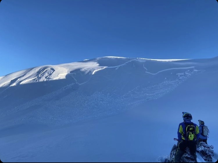
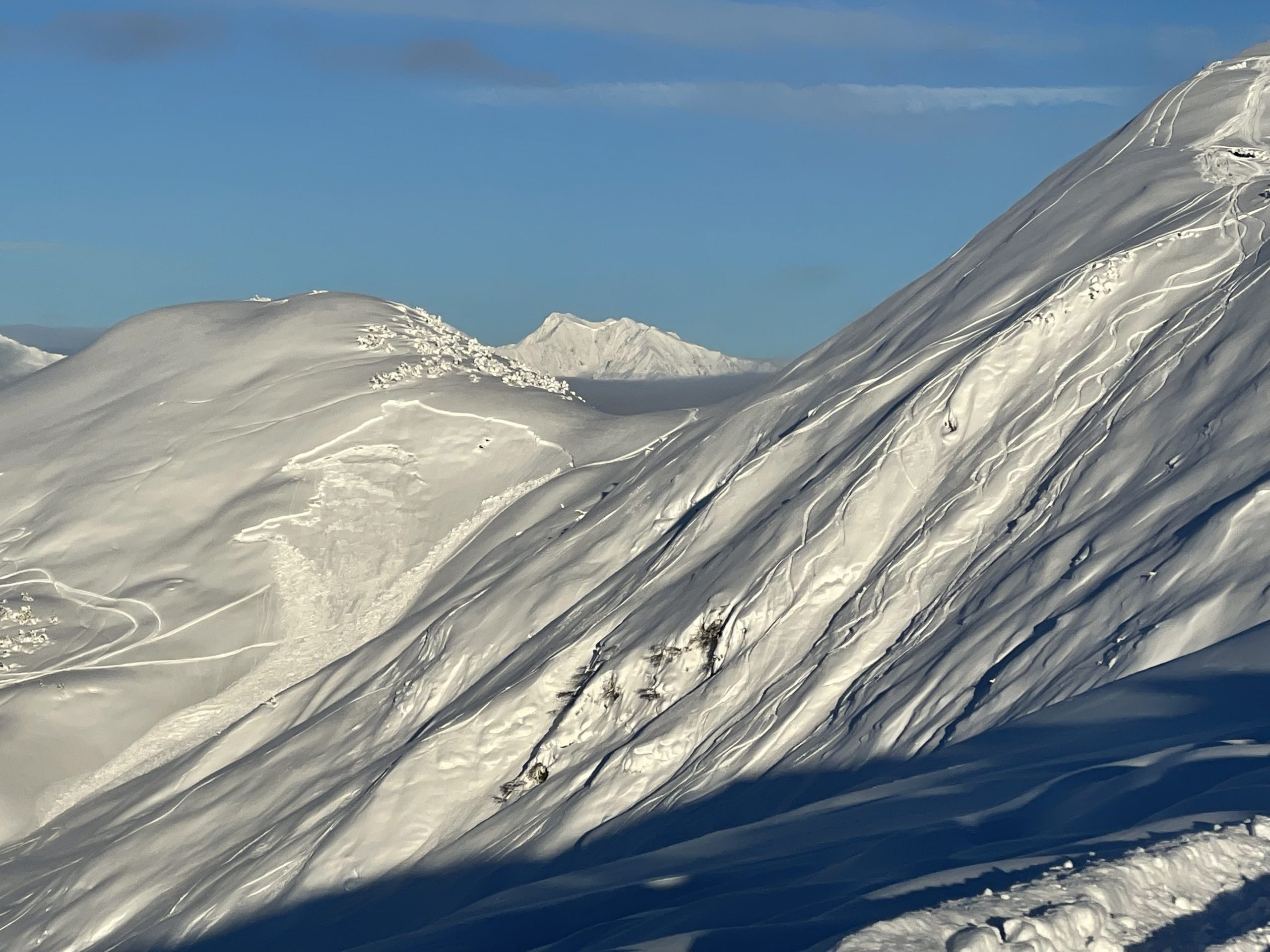
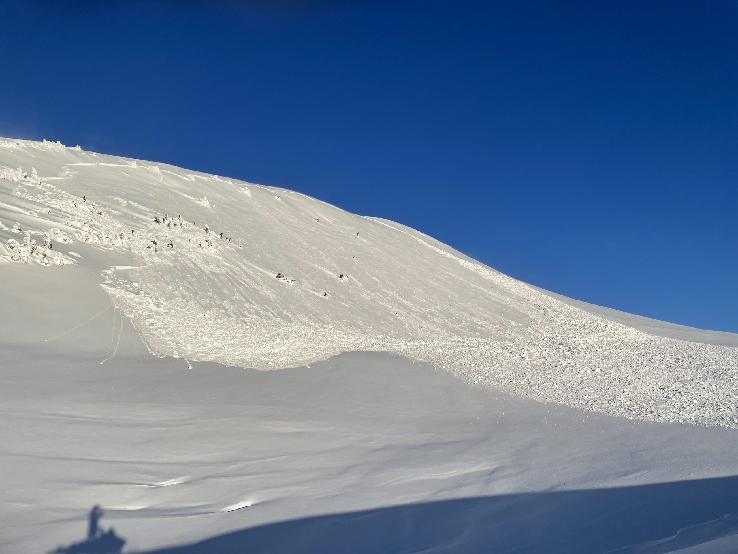
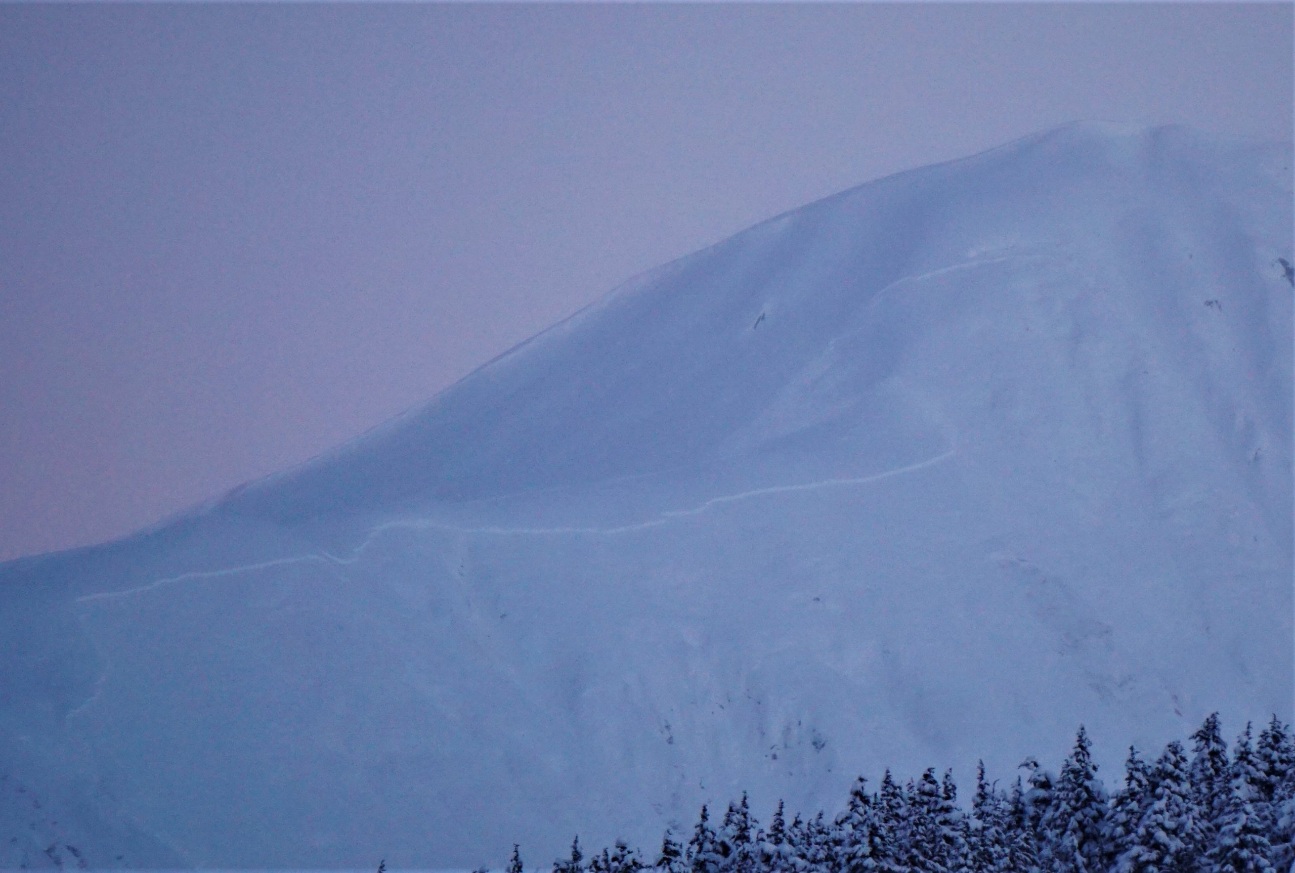
The avalanche danger is CONSIDERABLE today above 1000′. After seeing multiple large human-triggered avalanches yesterday, there is no question that dangerous avalanche conditions exist. The snowpack has shown us it is capable of producing avalanches hundreds of feet wide, 2-3′ deep or deeper, and being triggered remotely from above, below and adjacent to a slope. We’ve seen people triggering avalanches after there are multiple sets of tracks on a slope. We all need to take a collective step back with our terrain choices, following the travel advice for considerable danger:  Cautious route finding and conservative decision making are essential.

The danger remains MODERATE below 1000′, where the snowpack structure is not quite as alarming. While traveling in the lower elevations be sure to travel one at a time in steep terrain, watching your partners from safe spots. Pay attention to clear signs of instability like cracking and collapsing, and dial back your terrain choices if you notice any of the above.

Placer/Skookum: We still have no information for this zone, which was opened to motorized use this week. With heavier snowfall in the most recent storms, these areas most likely have the potential to produce very large avalanches. Use extra caution while traveling in this zone, especially if you are trying to get up high. Don’t be afraid to let us know what you see if you get out here- you can use this form.

Special Announcements
  • Friends of the Chugach Avalanche Center have scholarships available for avalanche education. Application deadline extended to December 15. See website for details on how to apply.
  • Chugach State Park: We’ve received multiple reports in the past few days of unstable conditions similar to what we have been seeing in Turnagain Pass and near Girdwood. This includes large collapses on a heavily traveled slope near Peak 3 and a remotely triggered avalanche near Eagle River. Use a little extra caution if you are getting out in these areas, and pay close attention for warning signs like shooting cracks and collapsing.
Fri, December 3rd, 2021
Alpine
Above 2,500'
3 - Considerable
Avalanche risk
Treeline
1,000'-2,500'
3 - Considerable
Avalanche risk
Below Treeline
Below 1,000'
2 - Moderate
Avalanche risk
0 - No Rating
1 - Low
2 - Moderate
3 - Considerable
4 - High
5 - Extreme
Avalanche risk Avalanche risk Avalanche risk Avalanche risk Avalanche risk
Travel Advice Generally safe avalanche conditions. Watch for unstable snow on isolated terrain features. Heightened avalanche conditions on specific terrain features. Evaluate snow and terrain carefully; identify features of concern. Dangerous avalanche conditions. Careful snowpack evaluation, cautious route-finding, and conservative decision-making essential. Very dangerous avalanche conditions. Travel in avalanche terrain not recommended. Extraordinarily dangerous avalanche conditions. Avoid all avalanche terrain.
Likelihood of Avalanches Natural and human-triggered avalanches unlikely. Natural avalanches unlikely; human-triggered avalanches possible. Natural avalanches possible; human-triggered avalanches likely. Natural avalanches likely; human-triggered avalanches very likely. Natural and human-triggered avalanches certain.
Avalanche Size and Distribution Small avalanches in isolated areas or extreme terrain. Small avalanches in specific areas; or large avalanches in isolated areas. Small avalanches in many areas; or large avalanches in specific areas; or very large avalanches in isolated areas. Large avalanches in many areas; or very large avalanches in specific areas. Very large avalanches in many areas.
Recent Avalanches

There were several near-misses yesterday in which skiers and snowmachiners triggered large avalanches. Luckily nobody was injured or killed. Here is what we saw:

Eddies: A skier triggered a large avalanche 1000′ wide, 3′ deep and running up to 1500′ while skinning up to the top of Eddie’s. The skier was caught and partially buried, but did not get carried for the entire path. Details here.

Seattle Ridge: We received multiple reports of snowmachine triggered avalanches on Seattle Ridge. Most of these appear to have been triggered remotely, and some were triggered after there were up to 10 sets of tracks on the slope. This includes avalanches in Little Sweeden, Widowmaker, Warmup bowl, and Triangle bowl. As far as we know nobody was caught in any of these avalanches. More details here and here.

Magnum: A skier triggered a large avalanche on the west face of Magnum. The skier was caught and carried, but was able to self-arrest before getting taken down the entire path. The avalanche appears to have been roughly 1000′ wide, running for about 1200′. Details here.

Looking down from the top of the crown on a skier-triggered avalanche on Eddie’s. The avalanche ran all the way into the valley bottom. Photo: George Creighton. 12.02.2021

This avalanche in Triangle bowl released sympathetically with two other avalanches. The initial avalanche was triggered in Warmup bowl on a slope that already had 10 sets of tracks immediately adjacent to the slide. Photo: Warren Gage. 12.02.2021

Avalanche Problem 1
  • Persistent Slabs
    Persistent Slabs
  • Certain
    Very Likely
    Likely
    Possible
    Unlikely
    Likelihood
  • Historic (D4-5)
    Very Large (D3)
    Large (D2)
    Small (D1)
    Size
Persistent Slabs
Persistent Slab avalanches are the release of a cohesive layer of snow (a slab) in the middle to upper snowpack, when the bond to an underlying persistent weak layer breaks. Persistent layers include: surface hoar, depth hoar, near-surface facets, or faceted snow. Persistent weak layers can continue to produce avalanches for days, weeks or even months, making them especially dangerous and tricky. As additional snow and wind events build a thicker slab on top of the persistent weak layer, this avalanche problem may develop into a Deep Persistent Slab.

Likelihood of Avalanches
Terms such as "unlikely", "likely", and "certain" are used to define the scale, with the chance of triggering or observing avalanches increasing as we move up the scale. For our purposes, "Unlikely" means that few avalanches could be triggered in avalanche terrain and natural avalanches are not expected. "Certain" means that humans will be able to trigger avalanches on many slopes, and natural avalanches are expected.

Size of Avalanches
Avalanche size is defined by the largest potential avalanche, or expected range of sizes related to the problem in question. Assigned size is a qualitative estimate based on the destructive classification system and requires specialists to estimate the harm avalanches may cause to hypothetical objects located in the avalanche track (AAA 2016, CAA 2014). Under this schema, "Small" avalanches are not large enough to bury humans and are relatively harmless unless they carry people over cliffs or through trees or rocks. Moving up the scale, avalanches become "Large" enough to bury, injure, or kill people. "Very Large" avalanches may bury or destroy vehicles or houses, and "Historic" avalanches are massive events capable of altering the landscape.

Signal Word Size (D scale) Simple Descriptor
Small 1 Unlikely to bury a person
Large 2 Can bury a person
Very Large 3 Can destroy a house
Historic 4 & 5 Can destroy part or all of a village
More info at Avalanche.org

Sometimes the mountains will softly whisper in our ears, giving us subtle clues that something is amiss. Other times they will shake us by the shoulders, slapping us across the face as they scream at us that we need to pay attention because conditions are dangerous. Yesterday was a case of the latter. We had reports of 7 human-triggered avalanches, all of which failed on weak, faceted snow buried 2-3′ deep. This includes a very large avalanche on Eddies (details here), 5 different large avalanches on Seattle ridge (details here and here), and a very large avalanche on Magnum. We also saw three large natural avalanches on Orca, which may have been a few days old but further demonstrate what the snowpack is capable of (details here).

There are a few things about the current snowpack that have our guard up. First of all, some of these avalanches are large- up to 1000′ wide and 3′ deep, propagating around significant terrain features. The second noteworthy detail is that a lot of these avalanches have been triggered remotely. This means a person can trigger an avalanche from below, adjacent to, or above a slope. The third issue is that we have seen avalanches failing after there were already multiple sets of tracks on a slope.

This type of avalanche problem can hang around for a while. It can also give us misleading or confusing feedback- the avalanche activity was noteworthy yesterday, but along with the handful of large avalanches were hundreds of tracks where people were getting into big terrain without consequence. The big takehome is that the snowpack is capable of producing large or very large avalanches, and people can trigger them. With another day of quiet weather today, we can expect to see similar conditions to what we saw yesterday. Luckily none of yesterday’s large avalanches resulted in injuries or worse. Today we all need to take a big step back with our terrain use and enjoy the soft snow on low-angle slopes, keeping an eye on our partners and being aware of the potential to remotely trigger an avalanche. There is still a whole lot of winter left, let’s all be patient and give this snowpack some time to heal.

Snowmachine-triggered avalanche near Widowmaker. Photo: Travis R. 12.02.2021

Remote-triggered avalanche near Little Sweeden. Photo: Travis R. 12.02.2021

Crown of the skier-triggered avalanche on Eddies. 12.02.2021

Additional Concern
  • Glide Avalanches
    Glide Avalanches
Glide Avalanches
Glide Avalanches are the release of the entire snow cover as a result of gliding over the ground. Glide avalanches can be composed of wet, moist, or almost entirely dry snow. They typically occur in very specific paths, where the slope is steep enough and the ground surface is relatively smooth. They are often proceeded by full depth cracks (glide cracks), though the time between the appearance of a crack and an avalanche can vary between seconds and months. Glide avalanches are unlikely to be triggered by a person, are nearly impossible to forecast, and thus pose a hazard that is extremely difficult to manage.
More info at Avalanche.org

We continue to monitor glide activity in the area. It looks like the glide avalanches have slowed down for now, but there are a lot of glide cracks around. Avoid spending time under these features since the can release unpredictably, and are very large and destructive when they do.

Weather
Fri, December 3rd, 2021

Yesterday: The weather was quiet yesterday, with highs in the single digits to mid teens F and overnight lows dropping to the single digits to low teens below 0 F. Winds were light with variable direction, and skies were mostly sunny for most of the day before fog rolled in later in the afternoon.

Today: We are expecting another day of cold and clear weather, with daytime highs in the single digits F and mostly sunny skies. Winds should be light out of the southwest at Turnagain Pass and out of the east/northeast near Girdwood. No precipitation is expected today.

Tomorrow: Lows should dip down to the single digits above and below 0 F tonight, before creeping up into the low teens F tomorrow. Cloud cover will increase during the day, but no precipitation is expected. Winds should be light out of the south. It is looking like Sunday night will be the soonest chance for another round of snow, with more active weather in the beginning of next week. Stay tuned for more.

PRECIPITATION 24-hour data (6am – 6am)

Temp Avg (F) Snow (in) Water (in) Snow Depth (in)
Center Ridge (1880′) 5 0 0 59
Summit Lake (1400′) 0 0 0 N/A
Alyeska Mid (1700′) 3 0 0 N/A

RIDGETOP 24-hour data (6am – 6am)

Temp Avg (F) Wind Dir Wind Avg (mph) Wind Gust (mph)
Sunburst (3812′) 3 W 2 9
Seattle Ridge (2400′) 4 NE 2 6
Observations
Recent Observations for Turnagain Pass
Date Region Location
04/21/24 Turnagain Observation: Bertha Creek
04/20/24 Turnagain Avalanche: Spokane Creek
04/16/24 Turnagain Observation: Cornbiscuit
04/15/24 Turnagain Observation: Taylor Pass
04/15/24 Turnagain Observation: Seward Highway – Tern Lake to Portage
04/14/24 Turnagain Observation: Sunburst
04/14/24 Turnagain Observation: Turnagain Pass Snomo
04/13/24 Turnagain Observation: Spokane Creek
04/11/24 Turnagain Observation: Tincan
04/10/24 Turnagain Avalanche: Seattle Ridge
Riding Areas

The riding areas page has moved. Please click here & update your bookmarks.


Subscribe to Turnagain Pass
Avalanche Forecast by Email

This is a general backcountry avalanche advisory issued for Turnagain Arm with Turnagain Pass as the core advisory area. This advisory does not apply to highways, railroads or operating ski areas.