Turnagain Pass RSS

Archives
ARCHIVED - Forecasts expire after 24 hours.
Issued
Fri, April 2nd, 2021 - 7:00AM
Expires
Sat, April 3rd, 2021 - 7:00AM
Forecaster
Andrew Schauer
Avalanche risk The Bottom Line

The avalanche danger is MODERATE today, and it is still possible to trigger an avalanche on weak layers of snow in the upper 3’ of the snowpack. Careful terrain selection remains important, especially avoiding steep terrain that funnels into traps like cliffs, rocks, gullies, or trees. As temperatures warm up in the afternoon, it will also be important to be aware of wet loose avalanches on southerly aspects.

SUMMIT LAKE/SNUG HARBOR/LOST LAKE/SEWARD: Winds are once again expected to be stronger near Seward, increasing the chances of triggering a wind-slab avalanche today.

Special Announcements

There have been multiple close calls involving partial burials in Chugach State Park over the past week. There is more info in our observations page (details here, here, and here). Extra caution is warranted if you plan to get out in this area today.

Fri, April 2nd, 2021
Alpine
Above 2,500'
2 - Moderate
Avalanche risk
Treeline
1,000'-2,500'
2 - Moderate
Avalanche risk
Below Treeline
Below 1,000'
2 - Moderate
Avalanche risk
0 - No Rating
1 - Low
2 - Moderate
3 - Considerable
4 - High
5 - Extreme
Avalanche risk Avalanche risk Avalanche risk Avalanche risk Avalanche risk
Travel Advice Generally safe avalanche conditions. Watch for unstable snow on isolated terrain features. Heightened avalanche conditions on specific terrain features. Evaluate snow and terrain carefully; identify features of concern. Dangerous avalanche conditions. Careful snowpack evaluation, cautious route-finding, and conservative decision-making essential. Very dangerous avalanche conditions. Travel in avalanche terrain not recommended. Extraordinarily dangerous avalanche conditions. Avoid all avalanche terrain.
Likelihood of Avalanches Natural and human-triggered avalanches unlikely. Natural avalanches unlikely; human-triggered avalanches possible. Natural avalanches possible; human-triggered avalanches likely. Natural avalanches likely; human-triggered avalanches very likely. Natural and human-triggered avalanches certain.
Avalanche Size and Distribution Small avalanches in isolated areas or extreme terrain. Small avalanches in specific areas; or large avalanches in isolated areas. Small avalanches in many areas; or large avalanches in specific areas; or very large avalanches in isolated areas. Large avalanches in many areas; or very large avalanches in specific areas. Very large avalanches in many areas.
Recent Avalanches

Crow Creek: Another large avalanche was reported on Raggedtop, which makes the third avalanche in the same area in the past two weeks. The avalanche likely failed on a weak layer that was capped by a wind slab, and was triggered naturally. Nobody was caught in the slide.

Natural avalanche on Raggedtop, right next to a previous avalanche from 03.26, and overrunning the slide from 03.21. Photo submitted by George Creighton, 04.01.2021

Avalanche Problem 1
  • Persistent Slabs
    Persistent Slabs
  • Certain
    Very Likely
    Likely
    Possible
    Unlikely
    Likelihood
  • Historic (D4-5)
    Very Large (D3)
    Large (D2)
    Small (D1)
    Size
Persistent Slabs
Persistent Slab avalanches are the release of a cohesive layer of snow (a slab) in the middle to upper snowpack, when the bond to an underlying persistent weak layer breaks. Persistent layers include: surface hoar, depth hoar, near-surface facets, or faceted snow. Persistent weak layers can continue to produce avalanches for days, weeks or even months, making them especially dangerous and tricky. As additional snow and wind events build a thicker slab on top of the persistent weak layer, this avalanche problem may develop into a Deep Persistent Slab.

Likelihood of Avalanches
Terms such as "unlikely", "likely", and "certain" are used to define the scale, with the chance of triggering or observing avalanches increasing as we move up the scale. For our purposes, "Unlikely" means that few avalanches could be triggered in avalanche terrain and natural avalanches are not expected. "Certain" means that humans will be able to trigger avalanches on many slopes, and natural avalanches are expected.

Size of Avalanches
Avalanche size is defined by the largest potential avalanche, or expected range of sizes related to the problem in question. Assigned size is a qualitative estimate based on the destructive classification system and requires specialists to estimate the harm avalanches may cause to hypothetical objects located in the avalanche track (AAA 2016, CAA 2014). Under this schema, "Small" avalanches are not large enough to bury humans and are relatively harmless unless they carry people over cliffs or through trees or rocks. Moving up the scale, avalanches become "Large" enough to bury, injure, or kill people. "Very Large" avalanches may bury or destroy vehicles or houses, and "Historic" avalanches are massive events capable of altering the landscape.

Signal Word Size (D scale) Simple Descriptor
Small 1 Unlikely to bury a person
Large 2 Can bury a person
Very Large 3 Can destroy a house
Historic 4 & 5 Can destroy part or all of a village
More info at Avalanche.org

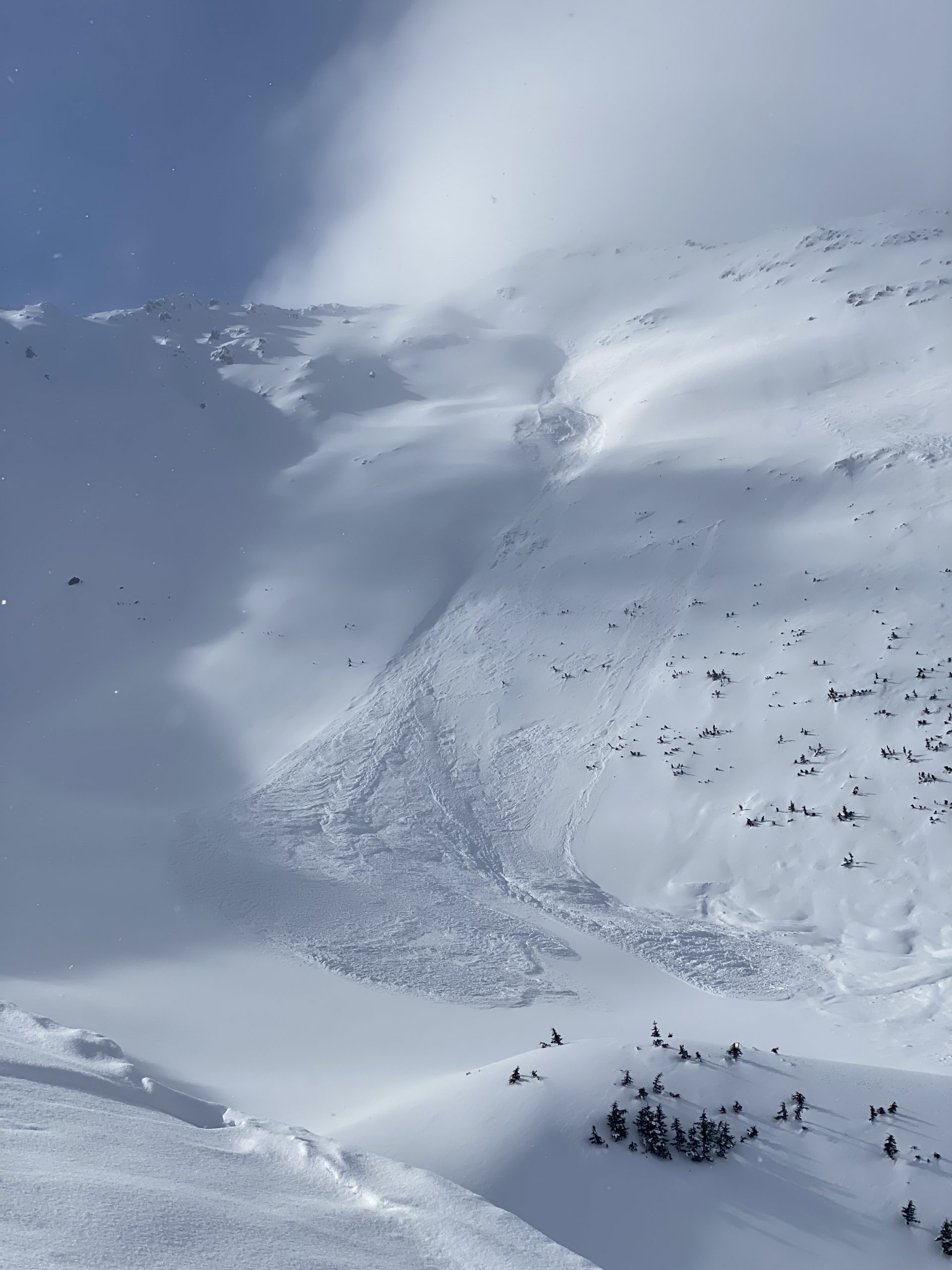
As we head into April, we continue to get reports of slab avalanche activity and other red flags associated with buried surface hoar and facets in the upper snowpack. This kind of activity is a clear indicator that the persistent weak layers that formed and were subsequently buried in March are still reactive, and still need to be considered when traveling in the mountains. These layers require patience and careful terrain selection, which means weighing the consequences of triggering an avalanche on the slope you are considering. For now, the snowpack is really not trustworthy and it is important to avoid steep slopes, especially those with terrain traps like rocks, cliffs, gullies, or trees, or avalanche paths with large, connected start zones. The most suspect slopes will be those that have a stiffer wind slab at or near the surface. Pay attention to clear indicators of instability like cracks shooting out from your snowmachine or skis, or the ‘whumpf’ of a collapse in the snowpack. The calendar may say that it is springtime, but the snowpack is still presenting us with all of the challenges of a mid-winter pack.

Wind slabs: Light to moderate winds overnight have likely created isolated wind-loaded pockets that may be sensitive to triggers today. Be on the lookout in the typical suspect terrain- below ridgelines, convexities, or in cross-loaded gullies.

Loose snow avalanches: Steep slopes that have been sheltered from the wind have around a foot of loose snow sitting on top of firm surfaces. It will be easy to trigger dry loose avalanches (sluffs) today, and they can pick up enough volume and speed to carry a person. If the sun stays out long enough, we will likely see some wet loose activity as well. While it is unlikely they will be big enough to bury you, they can be dangerous if they drag you into terrain traps like cliffs, trees, rocks, or gullies.

Weather
Fri, April 2nd, 2021

Yesterday: Skies were partly cloudy to mostly sunny, with high temperatures in the high teens F at ridgetops to low 30’s F at lower elevations. Winds were out of the west at 5-15 mph, and no precipitation was recorded.

Today: Partly cloudy skies are expected, with high temperatures in the high teens to high 20’s F. Westerly winds at 10-15 mph are expected to calm to around 5 mph later in the morning. No precipitation is expected today.

Tomorrow: Clouds are expected to move in tonight as the weather begins to change. We might see a few flurries during the day tomorrow, with chances of precipitation increasing Saturday night into Sunday morning. Winds are expected to shift towards the south but stay light at 5-10 mph. Expect to see overnight lows in the low teens to 20 F, with daytime highs in the mid 20’s to low 30’s F.

PRECIPITATION 24-hour data (6am – 6am)

Temp Avg (F) Snow (in) Water (in) Snow Depth (in)
Center Ridge (1880′) 22 0 0 111
Summit Lake (1400′) 17 0 0 50
Alyeska Mid (1700′) 21 0 0 117

RIDGETOP 24-hour data (6am – 6am)

Temp Avg (F) Wind Dir Wind Avg (mph) Wind Gust (mph)
Sunburst (3812′) 10 W 7 21
Seattle Ridge (2400′) 16 NNE-W 4 10
Observations
Recent Observations for Turnagain Pass
Date Region Location
04/16/24 Turnagain Observation: Cornbiscuit
04/15/24 Turnagain Observation: Taylor Pass
04/15/24 Turnagain Observation: Seward Highway – Tern Lake to Portage
04/14/24 Turnagain Observation: Sunburst
04/14/24 Turnagain Observation: Turnagain Pass Snomo
04/13/24 Turnagain Observation: Spokane Creek
04/11/24 Turnagain Observation: Tincan
04/10/24 Turnagain Avalanche: Seattle Ridge
04/10/24 Turnagain Observation: Cornbiscuit South Face
04/10/24 Turnagain Avalanche: Tincan
Riding Areas

The riding areas page has moved. Please click here & update your bookmarks.


Subscribe to Turnagain Pass
Avalanche Forecast by Email

This is a general backcountry avalanche advisory issued for Turnagain Arm with Turnagain Pass as the core advisory area. This advisory does not apply to highways, railroads or operating ski areas.