Turnagain Pass RSS

Archives
ARCHIVED - Forecasts expire after 24 hours.
Issued
Fri, January 20th, 2023 - 7:00AM
Expires
Sat, January 21st, 2023 - 7:00AM
Forecaster
Andrew Schauer
Avalanche risk The Bottom Line

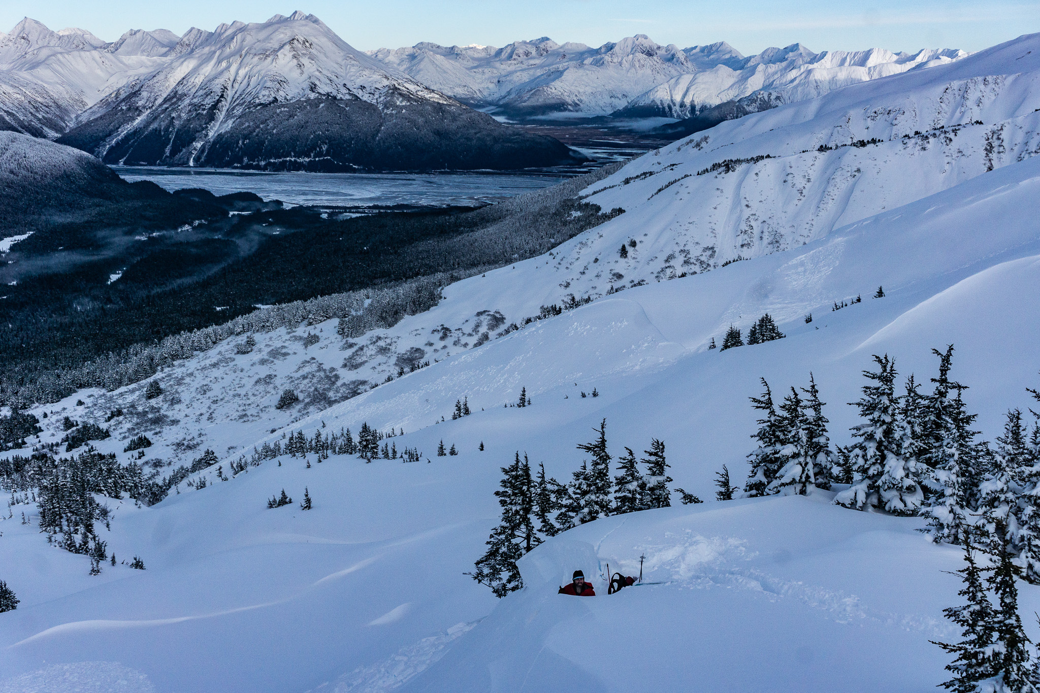
The avalanche danger is CONSIDERABLE above 1000′. Strong easterly winds should taper off mid-day, but the current snowpack still makes it likely a person can trigger an avalanche on buried surface hoar 1-2′ deep, and it is possible to trigger a much bigger avalanche on weak snow buried 3-7′ deep or deeper. This is an unusually dangerous snowpack for our area, and cautious terrain use is the only way to manage the problem. The danger is MODERATE below 1000′.

This setup means dangerous avalanche conditions will persist despite a few days of quiet weather on the horizon. If you are planning on getting out this weekend, be aware that we are dealing with some serious issues snowpack-wise, and now is not the time to push it into steep terrain.

Special Announcements

State of Alaska Department of Transportation & Public Facilities Avalanche Closure Notification:

There will be intermittent traffic delays today on the Seward Highway And the Portage Glacier Highway for Avalanche Hazard Reduction work:

  • From Milepost 88 to 85 on the Seward Highway South of Girdwood form 7:00 am to 9:00 am.
  • Near Milepost 5 and Bear Valley on the Portage Glacier Highway from 9:00 am to 2:00 pm.
  • From mileposts 100 to 90 on the Seward Highway, Girdwood to Bird Creek from 10:00 am 4:00 pm North of Girdwood.

Motorists should expect delays of 45 minutes or longer. Updates will be posted on the 511 system. http://511.alaska.gov/


If you have already taken a Rec 2 avalanche course, Alaska Guide Collective has spots open on their Rec 2 Refresher course. Join them to refresh your knowledge this Saturday and Sunday. Jan 21-22. More info at alaskaguidecollective.com/avalanche

Fri, January 20th, 2023
Alpine
Above 2,500'
3 - Considerable
Avalanche risk
Treeline
1,000'-2,500'
3 - Considerable
Avalanche risk
Below Treeline
Below 1,000'
2 - Moderate
Avalanche risk
0 - No Rating
1 - Low
2 - Moderate
3 - Considerable
4 - High
5 - Extreme
Avalanche risk Avalanche risk Avalanche risk Avalanche risk Avalanche risk
Travel Advice Generally safe avalanche conditions. Watch for unstable snow on isolated terrain features. Heightened avalanche conditions on specific terrain features. Evaluate snow and terrain carefully; identify features of concern. Dangerous avalanche conditions. Careful snowpack evaluation, cautious route-finding, and conservative decision-making essential. Very dangerous avalanche conditions. Travel in avalanche terrain not recommended. Extraordinarily dangerous avalanche conditions. Avoid all avalanche terrain.
Likelihood of Avalanches Natural and human-triggered avalanches unlikely. Natural avalanches unlikely; human-triggered avalanches possible. Natural avalanches possible; human-triggered avalanches likely. Natural avalanches likely; human-triggered avalanches very likely. Natural and human-triggered avalanches certain.
Avalanche Size and Distribution Small avalanches in isolated areas or extreme terrain. Small avalanches in specific areas; or large avalanches in isolated areas. Small avalanches in many areas; or large avalanches in specific areas; or very large avalanches in isolated areas. Large avalanches in many areas; or very large avalanches in specific areas. Very large avalanches in many areas.
Recent Avalanches

After four straight days of natural and human-triggered avalanches, we received no new reports of avalanche activity yesterday. Almost all of the recent activity has been failing on the layer of buried surface hoar, 1-2′ deep on average.

The last human-triggered avalanche on the Thanksgiving crust was 13 days ago, but it is likely the large natural avalanche on Kern Creek that occurred during the surprise storm this past Tuesday morning failed on that layer.

Avalanche Problem 1
  • Persistent Slabs
    Persistent Slabs
  • Aspect/Elevation
  • Certain
    Very Likely
    Likely
    Possible
    Unlikely
    Likelihood
  • Historic (D4-5)
    Very Large (D3)
    Large (D2)
    Small (D1)
    Size
Persistent Slabs
Persistent Slab avalanches are the release of a cohesive layer of snow (a slab) in the middle to upper snowpack, when the bond to an underlying persistent weak layer breaks. Persistent layers include: surface hoar, depth hoar, near-surface facets, or faceted snow. Persistent weak layers can continue to produce avalanches for days, weeks or even months, making them especially dangerous and tricky. As additional snow and wind events build a thicker slab on top of the persistent weak layer, this avalanche problem may develop into a Deep Persistent Slab.

Aspect/Elevation of the Avalanche Problem
Specialists develop a graphic representation of the potential distribution of a particular avalanche problem across the topography. This aspect/elevation rose is used to indicate where the particular avalanche problem is thought to exist on all elevation aspects. Areas where the avalanche problem is thought to exist are colored grey, and it is less likely to be encountered in areas colored white.

Likelihood of Avalanches
Terms such as "unlikely", "likely", and "certain" are used to define the scale, with the chance of triggering or observing avalanches increasing as we move up the scale. For our purposes, "Unlikely" means that few avalanches could be triggered in avalanche terrain and natural avalanches are not expected. "Certain" means that humans will be able to trigger avalanches on many slopes, and natural avalanches are expected.

Size of Avalanches
Avalanche size is defined by the largest potential avalanche, or expected range of sizes related to the problem in question. Assigned size is a qualitative estimate based on the destructive classification system and requires specialists to estimate the harm avalanches may cause to hypothetical objects located in the avalanche track (AAA 2016, CAA 2014). Under this schema, "Small" avalanches are not large enough to bury humans and are relatively harmless unless they carry people over cliffs or through trees or rocks. Moving up the scale, avalanches become "Large" enough to bury, injure, or kill people. "Very Large" avalanches may bury or destroy vehicles or houses, and "Historic" avalanches are massive events capable of altering the landscape.

Signal Word Size (D scale) Simple Descriptor
Small 1 Unlikely to bury a person
Large 2 Can bury a person
Very Large 3 Can destroy a house
Historic 4 & 5 Can destroy part or all of a village
More info at Avalanche.org

With quiet weather on the way today and tomorrow, and a snowpack that is primed for human-triggered avalanches, we are headed towards the scenario where accidents tend to happen. Easterly winds will be blowing 15-20 mph this morning, but backing off as they switch to a more northerly direction later in the day. We might see a trace to an inch of snow before the easterly flow shuts off, but the major loading event is wrapping up for now. Don’t let the quiet weather fool you- we’ve got a dangerous setup on our hands.

The layer of surface hoar that was buried 10 days ago has produced avalanches 4 out of the past 5 days. It remains likely a person can trigger an avalanche big enough to get buried or killed, and as far as we can tell the problem exists throughout the advisory area. We’ve found it in Eddie’s, Seattle Ridge, Tincan, Taylor Pass, Bertha Creek, and in Summit. Some weak layers are tricky to predict, lurking below the surface without giving signs of instability despite the potential for making big avalanches. This is not one of those subtle and difficult-to-predict weak layers. It is giving us plenty of evidence that it is still very reactive, capable of producing big avalanches despite being buried for 10 days now.

For now, the dangerous setup makes the travel advice simple: avoid steep terrain. We’ve seen a few of these avalanches triggered remotely, which means you can trigger an avalanche from low-angle terrain below or adjacent to a steeper slope. In addition to the more reactive surface hoar in the upper snowpack, remember we’ve also got a weak layer buried deeper in the snowpack that could produce a monster avalanche. More on that in Problem 2 below.

Wind Slabs: While the snowpack is likely to produce avalanches on any steep terrain today, it will be especially reactive where recent winds have built thicker wind slabs on the surface. Keep an eye out for touchy slabs on steep slopes just below ridgelines, in gullies, or on the downhill side of convex rolls.

One of the Pro 2 course people taking a look at an intentionally triggered avalanche on a test slope, with a natural avalanche on a wind-loaded slope in the background. Photo: Brady Deal. 01.17.2023

A trophy layer of buried surface hoar on Tenderfoot. Photo: Mike Janes 01.19.2023

Avalanche Problem 2
  • Deep Persistent Slabs
    Deep Persistent Slabs
  • Aspect/Elevation
  • Certain
    Very Likely
    Likely
    Possible
    Unlikely
    Likelihood
  • Historic (D4-5)
    Very Large (D3)
    Large (D2)
    Small (D1)
    Size
Deep Persistent Slabs
Deep Persistent Slab avalanches are the release of a thick cohesive layer of hard snow (a slab), when the bond breaks between the slab and an underlying persistent weak layer deep in the snowpack. The most common persistent weak layers involved in deep, persistent slabs are depth hoar or facets surrounding a deeply buried crust. Deep Persistent Slabs are typically hard to trigger, are very destructive and dangerous due to the large mass of snow involved, and can persist for months once developed. They are often triggered from areas where the snow is shallow and weak, and are particularly difficult to forecast for and manage.

Aspect/Elevation of the Avalanche Problem
Specialists develop a graphic representation of the potential distribution of a particular avalanche problem across the topography. This aspect/elevation rose is used to indicate where the particular avalanche problem is thought to exist on all elevation aspects. Areas where the avalanche problem is thought to exist are colored grey, and it is less likely to be encountered in areas colored white.

Likelihood of Avalanches
Terms such as "unlikely", "likely", and "certain" are used to define the scale, with the chance of triggering or observing avalanches increasing as we move up the scale. For our purposes, "Unlikely" means that few avalanches could be triggered in avalanche terrain and natural avalanches are not expected. "Certain" means that humans will be able to trigger avalanches on many slopes, and natural avalanches are expected.

Size of Avalanches
Avalanche size is defined by the largest potential avalanche, or expected range of sizes related to the problem in question. Assigned size is a qualitative estimate based on the destructive classification system and requires specialists to estimate the harm avalanches may cause to hypothetical objects located in the avalanche track (AAA 2016, CAA 2014). Under this schema, "Small" avalanches are not large enough to bury humans and are relatively harmless unless they carry people over cliffs or through trees or rocks. Moving up the scale, avalanches become "Large" enough to bury, injure, or kill people. "Very Large" avalanches may bury or destroy vehicles or houses, and "Historic" avalanches are massive events capable of altering the landscape.

Signal Word Size (D scale) Simple Descriptor
Small 1 Unlikely to bury a person
Large 2 Can bury a person
Very Large 3 Can destroy a house
Historic 4 & 5 Can destroy part or all of a village
More info at Avalanche.org

While it may be easier to trigger an avalanche on the surface hoar layer (Problem 1), the scarier problem might be the Thanksgiving crust/facet layer buried deeper in the snowpack. The last known human-triggered avalanche on this layer was nearly two weeks ago, but some of the large natural activity we saw early Tuesday morning likely failed on this layer. We’ve added 1.5-2″ snow water equivalent (SWE) to the snowpack over the past 3 days, which amounts to more stress pushing that weak layer closer to its breaking point.

The avalanches we’ve seen on the TG crust layer have propagated very wide, around multiple terrain features and even wrapping around entirely different aspects around prominent ridgelines. This is not the kind of avalanche problem you want to mess around with. Combined with the reactive buried surface hoar problem closer to the surface, the current setup is clearly dangerous. The only way to minimize your risk with this snowpack is by keeping your slope angles low, and minimizing time spent under steep terrain. These problems will go away eventually, but it just takes some patience to stick to mellow terrain while the snowpack heals.

Weather
Fri, January 20th, 2023

Yesterday: We received 0.3-0.5″ precipitation equalling 3-5″ snow, with the higher totals favoring Girdwood over Turnagain. Winds were blowing 15-25 mph out of the east with gusts to 35 mph. High temperatures were in the upper 20’s F near ridgelines and low 30’s F at lower elevations under mostly cloudy skies.

Today: Moderate easterly winds will continue at 15-20 mph this morning before backing off and switching more northerly this afternoon. Skies will be mostly cloudy, and we may see a trace to an inch of snow before the easterly flow shuts off. Temperatures should be in the upper 20’s to 30 F, dropping into the mid 20’s F tonight.

Tomorrow: It is looking like the clouds will break up tomorrow as northerly winds move in while the current low pressure system moves out to the east. Temperatures should hit the mid to upper 20’s F in the middle of the day before dropping into the teens in the afternoon. For now it is looking like the winds will be strongest tonight, blowing 15-25 mph out of the northwest before dropping down to 10-15 mph during the day tomorrow.

PRECIPITATION 24-hour data (6am – 6am)

Temp Avg (F) Snow (in) Water (in) Snow Depth (in)
Center Ridge (1880′) 30 3 0.3 68
Summit Lake (1400′) 29 0 0 31
Alyeska Mid (1700′) 30 4 0.36 69
Bear Valley – Portage (132′) 35 1 0.46

RIDGETOP 24-hour data (6am – 6am)

Temp Avg (F) Wind Dir Wind Avg (mph) Wind Gust (mph)
Sunburst (3812′) 22 ENE 15 35
Seattle Ridge (2400′) 25 ESE 9 20
Observations
Recent Observations for Turnagain Pass
Date Region Location
04/16/24 Turnagain Observation: Cornbiscuit
04/15/24 Turnagain Observation: Taylor Pass
04/15/24 Turnagain Observation: Seward Highway – Tern Lake to Portage
04/14/24 Turnagain Observation: Sunburst
04/14/24 Turnagain Observation: Turnagain Pass Snomo
04/13/24 Turnagain Observation: Spokane Creek
04/11/24 Turnagain Observation: Tincan
04/10/24 Turnagain Avalanche: Seattle Ridge
04/10/24 Turnagain Observation: Cornbiscuit South Face
04/10/24 Turnagain Avalanche: Tincan
Riding Areas

The riding areas page has moved. Please click here & update your bookmarks.


Subscribe to Turnagain Pass
Avalanche Forecast by Email

This is a general backcountry avalanche advisory issued for Turnagain Arm with Turnagain Pass as the core advisory area. This advisory does not apply to highways, railroads or operating ski areas.