The avalanche danger is CONSIDERABLE above 1000′ today. We have a dangerous combination of nice weather, soft snow, and a very unstable snowpack that commonly leads to avalanche accidents. Human triggered avalanches 1-3′ deep on a buried layer of surface hoar are likely. Triggering an avalanche from low angle terrain onto steeper adjacent slopes is also likely with this type of weak layer. It remains possible to trigger a very large avalanche 3-6′ deep above 2500′. We strongly recommend avoiding avalanche terrain today. Below 1000′ the avalanche danger is MODERATE.
Natural avalanches likely; human-triggered avalanches very likely.
Natural and human-triggered avalanches certain.
Avalanche Size and Distribution
Small avalanches in isolated areas or extreme terrain.
Small avalanches in specific areas; or large avalanches in isolated areas.
Small avalanches in many areas; or large avalanches in specific areas; or very large avalanches in isolated areas.
Large avalanches in many areas; or very large avalanches in specific areas.
Very large avalanches in many areas.
Recent Avalanches
One recent avalanche from Tincan was reported yesterday that looks like it released on the 1/10 layer of buried surface hoar. This is one example of numerous avalanches like this that have been triggered throughout the past week. The last known avalanche on the Thanksgiving crust/facet layer was two weeks ago on Cornbiscuit. Check out the video below to get a recap of some of the large avalanches we have observed in the forecast area during this period of unstable conditions over the past 2 weeks.
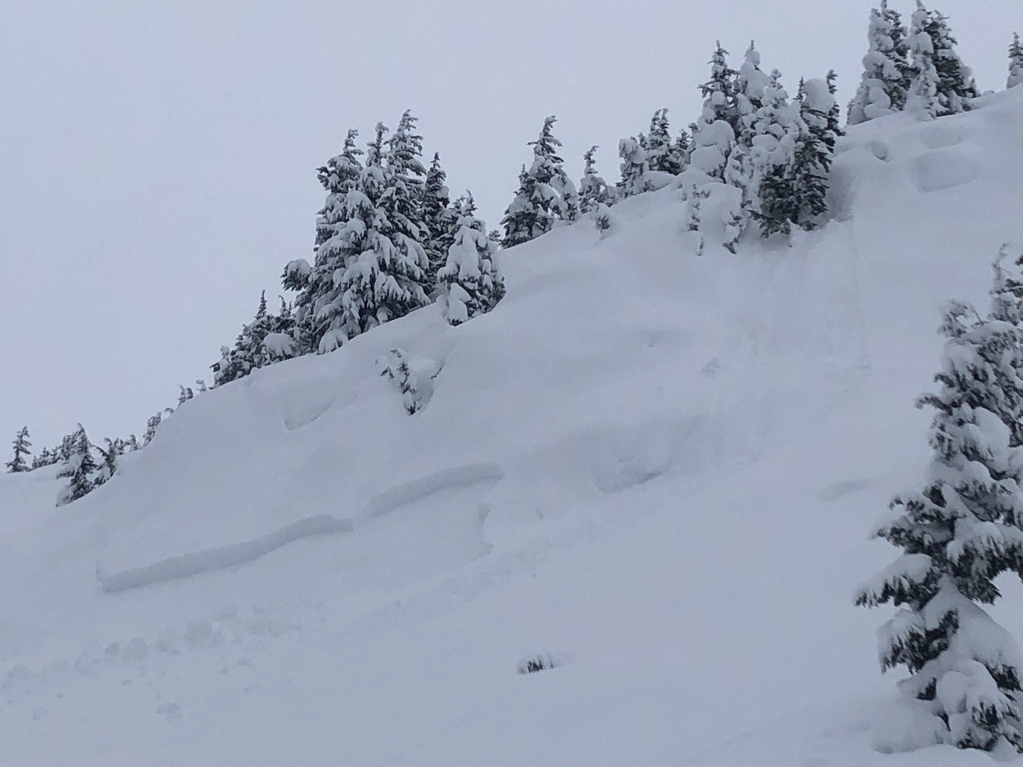
Avalanche on a small steep feature in Tincan trees that the observer thought was triggered by snow falling out of a tree! Photo 1.20.23
Avalanche Problem 1
Persistent Slabs
Aspect/Elevation
Certain
Very Likely
Likely
Possible
Unlikely
Likelihood
Historic (D4-5)
Very Large (D3)
Large (D2)
Small (D1)
Size
Persistent Slabs
Persistent Slab avalanches are the release of a cohesive layer of snow (a slab) in the middle to upper snowpack, when the bond to an underlying persistent weak layer breaks. Persistent layers include: surface hoar, depth hoar, near-surface facets, or faceted snow. Persistent weak layers can continue to produce avalanches for days, weeks or even months, making them especially dangerous and tricky. As additional snow and wind events build a thicker slab on top of the persistent weak layer, this avalanche problem may develop into a Deep Persistent Slab.
Aspect/Elevation of the Avalanche Problem
Specialists develop a graphic representation of the potential distribution of a particular avalanche problem across the topography.
This aspect/elevation rose is used to indicate where the particular avalanche problem is thought to exist on all elevation aspects.
Areas where the avalanche problem is thought to exist are colored grey, and it is less likely to be encountered in areas colored white.
Likelihood of Avalanches
Terms such as "unlikely", "likely", and "certain" are used to define the scale, with the chance of triggering or observing
avalanches increasing as we move up the scale. For our purposes, "Unlikely" means that few avalanches could be triggered in avalanche terrain and
natural avalanches are not expected. "Certain" means that humans will be able to trigger avalanches on many slopes, and natural avalanches are expected.
Size of Avalanches
Avalanche size is defined by the largest potential avalanche, or expected range of sizes related to the problem in question.
Assigned size is a qualitative estimate based on the destructive classification system and requires specialists to estimate the harm avalanches may cause to
hypothetical objects located in the avalanche track (AAA 2016, CAA 2014). Under this schema, "Small" avalanches are not large enough to bury humans and are
relatively harmless unless they carry people over cliffs or through trees or rocks. Moving up the scale, avalanches become "Large" enough to bury, injure,
or kill people. "Very Large" avalanches may bury or destroy vehicles or houses, and "Historic" avalanches are massive events capable of altering the landscape.
Today looks like it will be a beautiful day in the mountains. Cloud cover is expected to clear this afternoon, winds should remain light, and temperatures should drop into the teens. The combination of an idyllic winter day and soft snow on the surface will make it very tempting to start pushing onto steeper slopes today, but we have a very unstable snowpack across the forecast area. These conditions are the most common setup for human triggered avalanche accidents. Managing human factors will be the biggest challenge today.
We have seen lots of large natural and human triggered avalanches this week as well as very consistent unstable test results from our snowpit tests. A widespread layer of buried surface hoar 1-3′ deep has been causing most of the recent avalanches. The advice is simple to avoid this problem, just stay off slopes above 30 degrees and be very aware of steep slopes above you. Human triggered avalanches 1-3′ deep are likely. Buried surface hoar can produce avalanches on surprisingly low angle terrain and it is possible to remote trigger avalanches from low angle slopes onto adjacent steeper terrain. Due to the potential for remote triggers it is important to be aware of other groups travelling in your vicinity and avoid travelling above another group if possible.
Moderate winds at upper elevations yesterday transported snow near ridgelines and cross loaded gullies which could make avalanches on the buried surface hoar larger and more destructive. Areas that have seen recent wind loading can be identified by looking for a firmer snow surface and looking for signs of recent wind transport on the snow surface. Wind slabs are also possible for human triggering today at upper elevations.
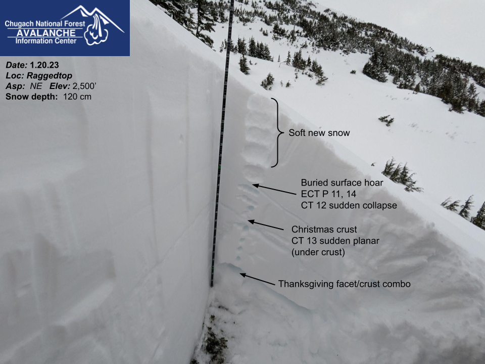
Snowpack structure on Raggedtop in the Crow Creek area of Girdwood yesterday. Widespread buried surface hoar was very reactive in our snowpit tests. Photo 1.20.23
Avalanche Problem 2
Deep Persistent Slabs
Aspect/Elevation
Certain
Very Likely
Likely
Possible
Unlikely
Likelihood
Historic (D4-5)
Very Large (D3)
Large (D2)
Small (D1)
Size
Deep Persistent Slabs
Deep Persistent Slab avalanches are the release of a thick cohesive layer of hard snow (a slab), when the bond breaks between the slab and an underlying persistent weak layer deep in the snowpack. The most common persistent weak layers involved in deep, persistent slabs are depth hoar or facets surrounding a deeply buried crust. Deep Persistent Slabs are typically hard to trigger, are very destructive and dangerous due to the large mass of snow involved, and can persist for months once developed. They are often triggered from areas where the snow is shallow and weak, and are particularly difficult to forecast for and manage.
Aspect/Elevation of the Avalanche Problem
Specialists develop a graphic representation of the potential distribution of a particular avalanche problem across the topography.
This aspect/elevation rose is used to indicate where the particular avalanche problem is thought to exist on all elevation aspects.
Areas where the avalanche problem is thought to exist are colored grey, and it is less likely to be encountered in areas colored white.
Likelihood of Avalanches
Terms such as "unlikely", "likely", and "certain" are used to define the scale, with the chance of triggering or observing
avalanches increasing as we move up the scale. For our purposes, "Unlikely" means that few avalanches could be triggered in avalanche terrain and
natural avalanches are not expected. "Certain" means that humans will be able to trigger avalanches on many slopes, and natural avalanches are expected.
Size of Avalanches
Avalanche size is defined by the largest potential avalanche, or expected range of sizes related to the problem in question.
Assigned size is a qualitative estimate based on the destructive classification system and requires specialists to estimate the harm avalanches may cause to
hypothetical objects located in the avalanche track (AAA 2016, CAA 2014). Under this schema, "Small" avalanches are not large enough to bury humans and are
relatively harmless unless they carry people over cliffs or through trees or rocks. Moving up the scale, avalanches become "Large" enough to bury, injure,
or kill people. "Very Large" avalanches may bury or destroy vehicles or houses, and "Historic" avalanches are massive events capable of altering the landscape.
It has been two weeks since the near miss on Cornbiscuit which failed on the Thanksgiving facet/crust layer buried 3-6′ deep. Despite the lack of avalanche activity since that event we have still seen observations of weak snowpack structure on this layer and it is still possible for a person to trigger a very large avalanche. The most likely place to trigger this deeply buried weak layer is from a thin spot in the snowpack, such as where wind has scoured the snowpack near ridgelines and where rocks are penetrating through the snowpack. This layer is most likely to be triggered above 2500′. Triggering a shallower avalanche on the buried surface hoar (problem 1) could step down to this deeper weak layer and cause a very large avalanche. We recommend sticking to low angle terrain and smaller terrain features as well as being aware of any overhead avalanche paths to avoid this problem.
* Yes, this was in the forecast yesterday but it was to clever not to use it again!
Weather
Sat, January 21st, 2023
Yesterday: Overcast to obscured cloud cover with periods of moderate snow and rain. We received about 0.4″ water or 3-6″ of snow in Girdwood and Turnagain Pass over the past 24 hours, with some falling Friday morning and then another pulse of snowfall overnight. Snowline was at about 500-700′ yesterday. Winds were strongest Friday morning with averages of 15-20 mph at upper elevations and gusts to 40 mph until about 1:00 pm. Since then the winds have dropped to 0-10 mph averages and gusts up to 15 mph.
Today: Trending toward clearing skies and dropping temperatures today before the next storm moves into the area overnight Saturday. Temperatures should drop towards the teens F in the afternoon and evening as cloud cover clears. Winds are expected to remain out of the NW with averages of 5-15 mph. Snowfall is expected to resume on Sunday morning.
Tomorrow: Snowfall and strong winds are expected on Sunday with 4-6″ of snow in Girdwood and Turnagain Pass by Monday morning. Winds should start to increase early Sunday morning and increase to averages of 30-40 mph and gusts of 50+ mph Sunday afternoon or evening. Snowline should be below 500′ during the day Sunday before rising to 1000′ overnight. Temperatures will move back up to the mid 20s F at upper elevations and low 30s F at low elevations.
This is a general backcountry avalanche advisory issued for Turnagain Arm with Turnagain Pass as the core advisory area.
This advisory does not apply to highways, railroads or operating ski areas.