Turnagain Pass RSS

Archives
ARCHIVED - Forecasts expire after 24 hours.
Issued
Thu, January 19th, 2023 - 7:00AM
Expires
Fri, January 20th, 2023 - 7:00AM
Forecaster
John Sykes
Avalanche risk The Bottom Line

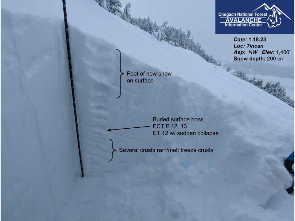
The avalanche danger is HIGH above 2500′ today. Strong winds over the past 24 hours have been transporting snow onto buried weak layers that are likely to produce natural avalanches and very likely to produce human triggered avalanches 1-3’+ deep. It is also possible to trigger a very large avalanche on a buried weak layer 3-6′ deep. Travel in avalanche terrain is not recommended.

Below 2500′ the avalanche danger is CONSIDERABLE. Human triggered avalanches 1-3′ deep releasing on buried weak layers are likely and we have seen several recent avalanches on forested low elevation and low angle slopes. Remote triggering an avalanche from low angle terrain onto surrounding steeper terrain is also possible with these buried weak layers.

SEWARD/LOST LAKE: This area is expected to receive higher snowfall totals (6-12″+) than our forecast area over the next 24 hours. Avalanche danger will increase rapidly with new snowfall and wind, and buried weak layers could become active again. We recommend very conservative terrain selection and avoiding avalanche terrain altogether if you see any red flags.

Special Announcements

If you have done a Rec 2 avalanche course already, Alaska Guide Collective has spots open on their Rec 2 Refresher course. Join them to refresh your knowledge this Saturday and Sunday. Jan 21-22. alaskaguidecollective.com/avalanche

Forecaster Chat #2:  Join us at the Girdwood Brewing Co. from 5:30-7:00 p.m. Tonight! CNFAIC forecaster Andrew Schauer will open the night with an overview of the state of the snowpack, followed by a discussion on how safe terrain management changes depending on the type of avalanche problem at hand. More details here.

Thu, January 19th, 2023
Alpine
Above 2,500'
4 - High
Avalanche risk
Treeline
1,000'-2,500'
3 - Considerable
Avalanche risk
Below Treeline
Below 1,000'
3 - Considerable
Avalanche risk
0 - No Rating
1 - Low
2 - Moderate
3 - Considerable
4 - High
5 - Extreme
Avalanche risk Avalanche risk Avalanche risk Avalanche risk Avalanche risk
Travel Advice Generally safe avalanche conditions. Watch for unstable snow on isolated terrain features. Heightened avalanche conditions on specific terrain features. Evaluate snow and terrain carefully; identify features of concern. Dangerous avalanche conditions. Careful snowpack evaluation, cautious route-finding, and conservative decision-making essential. Very dangerous avalanche conditions. Travel in avalanche terrain not recommended. Extraordinarily dangerous avalanche conditions. Avoid all avalanche terrain.
Likelihood of Avalanches Natural and human-triggered avalanches unlikely. Natural avalanches unlikely; human-triggered avalanches possible. Natural avalanches possible; human-triggered avalanches likely. Natural avalanches likely; human-triggered avalanches very likely. Natural and human-triggered avalanches certain.
Avalanche Size and Distribution Small avalanches in isolated areas or extreme terrain. Small avalanches in specific areas; or large avalanches in isolated areas. Small avalanches in many areas; or large avalanches in specific areas; or very large avalanches in isolated areas. Large avalanches in many areas; or very large avalanches in specific areas. Very large avalanches in many areas.
Recent Avalanches

During a brief period of decent visibility yesterday we saw several new avalanches from the past 2 days in Turnagain Pass. Most of these look like they released on a layer of buried surface hoar about 1-3′ deep and were at low and mid elevations (1400-2400′). Visibility was poor at upper elevations so if there were recent avalanches up high we might not have been able to see them.

Several crowns along mid elevations of Seattle Ridge at 1500 – 2000′ that had wide propagation that indicates buried surface hoar as the weak layer. Photo 1.18.23

Zoomed in view of smaller avalanches that released on pretty low angle slopes at about 1500′ on the SW aspect of Seattle Ridge. Photo 1.18.23

Another avalanche on SW aspect of Seattle Ridge at 2300′ that was closer to the motorized uptrack with similar wide propagation indicative of surface hoar as the weak layer. Photo 1.18.23

Avalanche Problem 1
  • Persistent Slabs
    Persistent Slabs
  • Aspect/Elevation
  • Certain
    Very Likely
    Likely
    Possible
    Unlikely
    Likelihood
  • Historic (D4-5)
    Very Large (D3)
    Large (D2)
    Small (D1)
    Size
Persistent Slabs
Persistent Slab avalanches are the release of a cohesive layer of snow (a slab) in the middle to upper snowpack, when the bond to an underlying persistent weak layer breaks. Persistent layers include: surface hoar, depth hoar, near-surface facets, or faceted snow. Persistent weak layers can continue to produce avalanches for days, weeks or even months, making them especially dangerous and tricky. As additional snow and wind events build a thicker slab on top of the persistent weak layer, this avalanche problem may develop into a Deep Persistent Slab.

Aspect/Elevation of the Avalanche Problem
Specialists develop a graphic representation of the potential distribution of a particular avalanche problem across the topography. This aspect/elevation rose is used to indicate where the particular avalanche problem is thought to exist on all elevation aspects. Areas where the avalanche problem is thought to exist are colored grey, and it is less likely to be encountered in areas colored white.

Likelihood of Avalanches
Terms such as "unlikely", "likely", and "certain" are used to define the scale, with the chance of triggering or observing avalanches increasing as we move up the scale. For our purposes, "Unlikely" means that few avalanches could be triggered in avalanche terrain and natural avalanches are not expected. "Certain" means that humans will be able to trigger avalanches on many slopes, and natural avalanches are expected.

Size of Avalanches
Avalanche size is defined by the largest potential avalanche, or expected range of sizes related to the problem in question. Assigned size is a qualitative estimate based on the destructive classification system and requires specialists to estimate the harm avalanches may cause to hypothetical objects located in the avalanche track (AAA 2016, CAA 2014). Under this schema, "Small" avalanches are not large enough to bury humans and are relatively harmless unless they carry people over cliffs or through trees or rocks. Moving up the scale, avalanches become "Large" enough to bury, injure, or kill people. "Very Large" avalanches may bury or destroy vehicles or houses, and "Historic" avalanches are massive events capable of altering the landscape.

Signal Word Size (D scale) Simple Descriptor
Small 1 Unlikely to bury a person
Large 2 Can bury a person
Very Large 3 Can destroy a house
Historic 4 & 5 Can destroy part or all of a village
More info at Avalanche.org

We got a lot less snowfall over the past 24 hours than had been previously predicted, with 2-4″ falling in Turnagain Pass and 3-6″ in Girdwood. The winds are the bigger story today with averages of 15-25 mph and gusts of 50+ mph over the past 24 hours. There will be a lot of snow being transported at upper elevations thanks to the 12+” of soft snow on the surface from the surprise storm on Monday night. This rapid loading is piling onto a layer of buried surface hoar about 1-3′ deep that is widespread across the forecast area. Large natural avalanches are likely and human triggered avalanches are very likely 1-3′ deep in areas where this buried surface boar is being loaded by wind transported snow.  Travel in avalanche terrain is not recommended.

Surface hoar tends to produce avalanches on surprisingly low angle slopes with very wide propagation, as we have seen in recent avalanches on the SW aspect of Seattle Ridge. This can easily catch people off guard because avalanches can occur in areas that are typically safe. In the past few days there have been several remote triggered avalanches on this layer, which means you could trigger an avalanche from low angle terrain onto steeper slopes above, below, or across from where you are travelling. It is important to be aware of other groups in your area and to avoid spending time underneath steeper terrain features and avalanche paths.

Wind slabs 1-2′ deep are also likely today and could trigger a larger avalanche on either the buried surface hoar or the Thanksgiving facet/crust combination, which has produced a lot of very large avalanches in the forecast area in the past two weeks (see problem 2).

Snowpack structure at low elevations on Tincan in an area where we triggered several collapses near the normal skin track. Photo 1.18.23

Avalanche Problem 2
  • Deep Persistent Slabs
    Deep Persistent Slabs
  • Aspect/Elevation
  • Certain
    Very Likely
    Likely
    Possible
    Unlikely
    Likelihood
  • Historic (D4-5)
    Very Large (D3)
    Large (D2)
    Small (D1)
    Size
Deep Persistent Slabs
Deep Persistent Slab avalanches are the release of a thick cohesive layer of hard snow (a slab), when the bond breaks between the slab and an underlying persistent weak layer deep in the snowpack. The most common persistent weak layers involved in deep, persistent slabs are depth hoar or facets surrounding a deeply buried crust. Deep Persistent Slabs are typically hard to trigger, are very destructive and dangerous due to the large mass of snow involved, and can persist for months once developed. They are often triggered from areas where the snow is shallow and weak, and are particularly difficult to forecast for and manage.

Aspect/Elevation of the Avalanche Problem
Specialists develop a graphic representation of the potential distribution of a particular avalanche problem across the topography. This aspect/elevation rose is used to indicate where the particular avalanche problem is thought to exist on all elevation aspects. Areas where the avalanche problem is thought to exist are colored grey, and it is less likely to be encountered in areas colored white.

Likelihood of Avalanches
Terms such as "unlikely", "likely", and "certain" are used to define the scale, with the chance of triggering or observing avalanches increasing as we move up the scale. For our purposes, "Unlikely" means that few avalanches could be triggered in avalanche terrain and natural avalanches are not expected. "Certain" means that humans will be able to trigger avalanches on many slopes, and natural avalanches are expected.

Size of Avalanches
Avalanche size is defined by the largest potential avalanche, or expected range of sizes related to the problem in question. Assigned size is a qualitative estimate based on the destructive classification system and requires specialists to estimate the harm avalanches may cause to hypothetical objects located in the avalanche track (AAA 2016, CAA 2014). Under this schema, "Small" avalanches are not large enough to bury humans and are relatively harmless unless they carry people over cliffs or through trees or rocks. Moving up the scale, avalanches become "Large" enough to bury, injure, or kill people. "Very Large" avalanches may bury or destroy vehicles or houses, and "Historic" avalanches are massive events capable of altering the landscape.

Signal Word Size (D scale) Simple Descriptor
Small 1 Unlikely to bury a person
Large 2 Can bury a person
Very Large 3 Can destroy a house
Historic 4 & 5 Can destroy part or all of a village
More info at Avalanche.org

The last large natural avalanche cycle on the Thanksgiving facet/crust layer occurred after a short but intense snow storm followed by strong winds on Jan 4th. These are similar conditions to what we have seen in the past 24-48 hours, so we think the potential for very large avalanches 3-6’+ deep is higher today. There is also the possibility of an avalanche releasing on a shallower layer, like a wind slab or persistent slab on buried surface hoar (see problem 1), then stepping down to this deeply buried weak layer and creating a much larger avalanche. With the stormy weather so far this week it has been difficult to get into higher elevation terrain to look for recent avalanche activity on this deeper weak layer, so we are uncertain whether the recent storm has caused natural avalanche activity. This layer is most concerning above 2500′ and is most likely to be triggered from a thin spot in the snowpack, like near a wind scoured ridgeline or where rocks penetrate part way through the snowpack.

Weather
Thu, January 19th, 2023

Yesterday: Mostly cloudy in the morning then transitioned to obscured cloud cover in the afternoon. Moderate winds speeds throughout the day increasing overnight to 15-25 mph averages and gusts up to 50 mph at upper elevations. Snowfall was in and out yesterday, with Portage receiving 0.5″, Girdwood in second with 0.3″ of water, and then Turnagain Pass showing only 0.1″ of water. Temperatures were in the low 20s F at upper elevations and low to mid 30s F at sea level. Snow line appears to have remained at sea level but there may have been some periods of wet snow or rain at the lowest elevations.

Today: Snowfall will continue today with a total of 4-6″ of new snow expected by Friday morning in Turnagain Pass and Girdwood. Favored areas along the coast near Portage and Whittier could see closer to 12-18″ of new snow in the next 24 hours.  Snowline will be rising throughout the day and is expected to reach 1000-1300′ Thursday night into Friday. Winds will remain strong out of the east with averages of 20-30 mph and gusts to 50+ mph until the afternoon when they should start to die down.

Tomorrow: Continued snowfall is expected on Friday with 2-3″ of additional new snow by Saturday morning. Wind speeds should decrease slightly with averages of 10-25 mph. Snowline is expected to peak up to 1000-1300′ early Friday morning then drop back to 500-600′ on Friday evening. Temperatures in the mid 20s F at upper elevations and mid 30s F at lower elevations.

PRECIPITATION 24-hour data (6am – 6am)

Temp Avg (F) Snow (in) Water (in) Snow Depth (in)
Center Ridge (1880′) 29 2 0.2 66
Summit Lake (1400′) 21 1 0.1 32
Alyeska Mid (1700′) 28 3 0.3 66
Bear Valley – Portage (132′) 34 5 0.5

RIDGETOP 24-hour data (6am – 6am)

Temp Avg (F) Wind Dir Wind Avg (mph) Wind Gust (mph)
Sunburst (3812′) 20 ENE 17 50
Seattle Ridge (2400′) 23 SE 11 22
Observations
Recent Observations for Turnagain Pass
Date Region Location
04/16/24 Turnagain Observation: Cornbiscuit
04/15/24 Turnagain Observation: Taylor Pass
04/15/24 Turnagain Observation: Seward Highway – Tern Lake to Portage
04/14/24 Turnagain Observation: Sunburst
04/14/24 Turnagain Observation: Turnagain Pass Snomo
04/13/24 Turnagain Observation: Spokane Creek
04/11/24 Turnagain Observation: Tincan
04/10/24 Turnagain Avalanche: Seattle Ridge
04/10/24 Turnagain Observation: Cornbiscuit South Face
04/10/24 Turnagain Avalanche: Tincan
Riding Areas

The riding areas page has moved. Please click here & update your bookmarks.


Subscribe to Turnagain Pass
Avalanche Forecast by Email

This is a general backcountry avalanche advisory issued for Turnagain Arm with Turnagain Pass as the core advisory area. This advisory does not apply to highways, railroads or operating ski areas.