Turnagain Pass RSS

Archives
ARCHIVED - Forecasts expire after 24 hours.
Issued
Mon, January 3rd, 2022 - 7:00AM
Expires
Tue, January 4th, 2022 - 7:00AM
Forecaster
John Sykes
Avalanche risk The Bottom Line

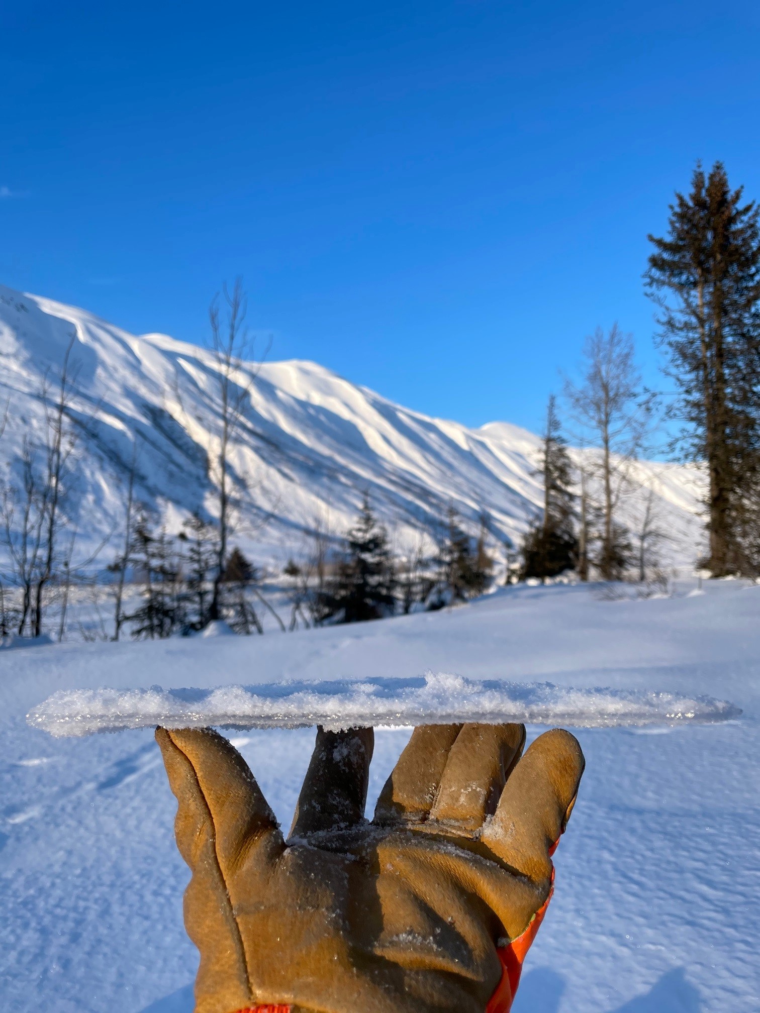
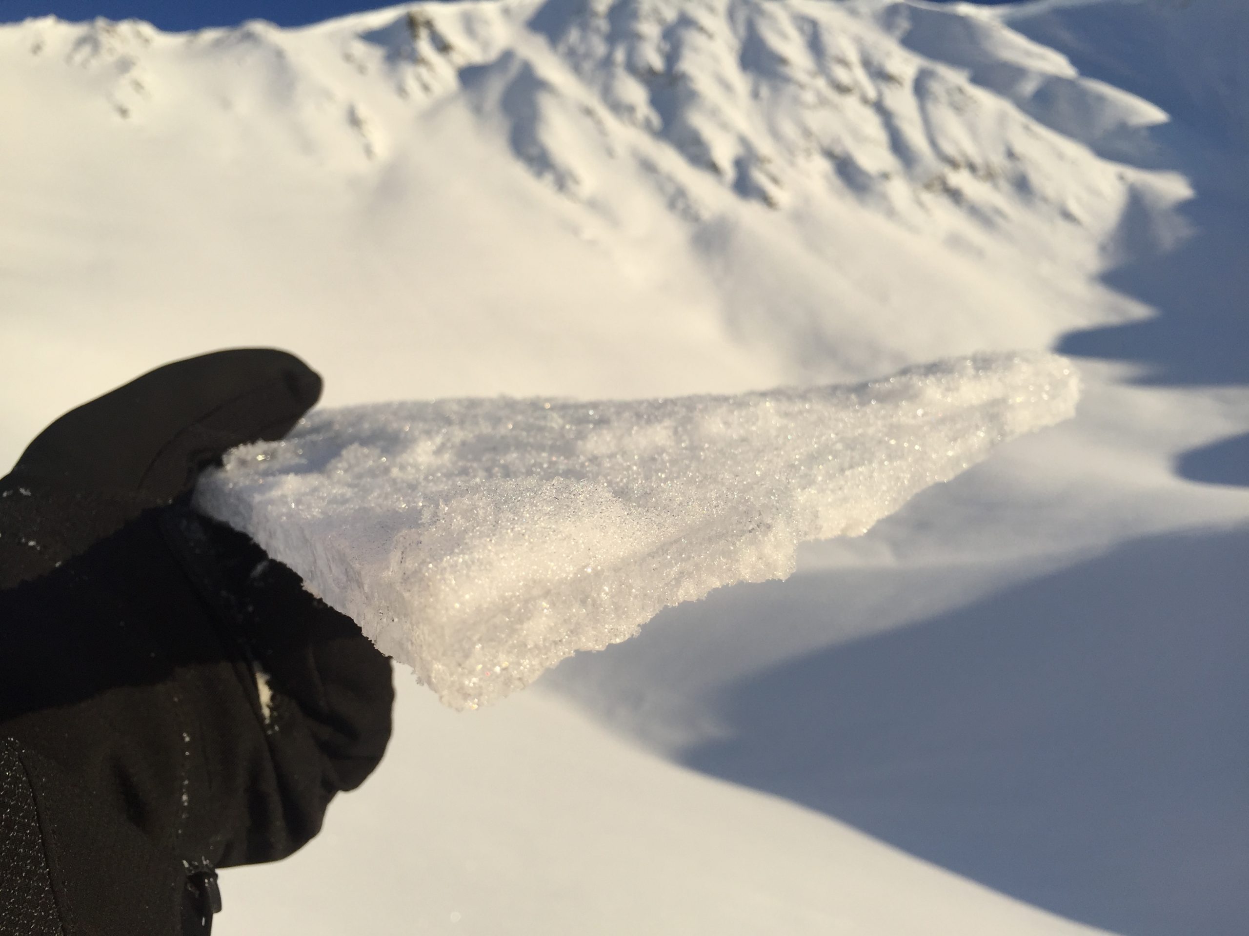
The avalanche danger is MODERATE above 2500′ where it will be possible to trigger a lingering wind slab around a foot deep. Look for signs of recent wind loading on the snow surface and shooting cracks to locate areas that have sensitive wind slabs. Just under the surface there is an icy crust that is making for challenging travel conditions right now. This crust can cause avalanches to run faster and further than normal and could create a sliding hazard if you are knocked off your feet in steep terrain by a small avalanche.

Below 2500′ the avalanche danger is LOW where triggering an avalanche is unlikely.

Special Announcements
  • Forecaster Chat – January 11th: Mark your calendar! John Sykes will be doing an interview and audience Q & A with avalanche scientist Pascal Haegeli, from Simon Fraser University in Canada. Topic: How do backcountry users interpret and apply the avalanche forecast. Details HERE
  • The avalanche science community needs your help! Please consider participating in the following study that focuses on where one decides to go in the backcountry. Details and how to sign up HERE!
Mon, January 3rd, 2022
Alpine
Above 2,500'
2 - Moderate
Avalanche risk
Treeline
1,000'-2,500'
1 - Low
Avalanche risk
Below Treeline
Below 1,000'
1 - Low
Avalanche risk
0 - No Rating
1 - Low
2 - Moderate
3 - Considerable
4 - High
5 - Extreme
Avalanche risk Avalanche risk Avalanche risk Avalanche risk Avalanche risk
Travel Advice Generally safe avalanche conditions. Watch for unstable snow on isolated terrain features. Heightened avalanche conditions on specific terrain features. Evaluate snow and terrain carefully; identify features of concern. Dangerous avalanche conditions. Careful snowpack evaluation, cautious route-finding, and conservative decision-making essential. Very dangerous avalanche conditions. Travel in avalanche terrain not recommended. Extraordinarily dangerous avalanche conditions. Avoid all avalanche terrain.
Likelihood of Avalanches Natural and human-triggered avalanches unlikely. Natural avalanches unlikely; human-triggered avalanches possible. Natural avalanches possible; human-triggered avalanches likely. Natural avalanches likely; human-triggered avalanches very likely. Natural and human-triggered avalanches certain.
Avalanche Size and Distribution Small avalanches in isolated areas or extreme terrain. Small avalanches in specific areas; or large avalanches in isolated areas. Small avalanches in many areas; or large avalanches in specific areas; or very large avalanches in isolated areas. Large avalanches in many areas; or very large avalanches in specific areas. Very large avalanches in many areas.
Avalanche Problem 1
  • Wind Slabs
    Wind Slabs
  • Certain
    Very Likely
    Likely
    Possible
    Unlikely
    Likelihood
  • Historic (D4-5)
    Very Large (D3)
    Large (D2)
    Small (D1)
    Size
Wind Slabs
Wind Slab avalanches are the release of a cohesive layer of snow (a slab) formed by the wind. Wind typically transports snow from the upwind sides of terrain features and deposits snow on the downwind side. Wind slabs are often smooth and rounded and sometimes sound hollow, and can range from soft to hard. Wind slabs that form over a persistent weak layer (surface hoar, depth hoar, or near-surface facets) may be termed Persistent Slabs or may develop into Persistent Slabs.

Likelihood of Avalanches
Terms such as "unlikely", "likely", and "certain" are used to define the scale, with the chance of triggering or observing avalanches increasing as we move up the scale. For our purposes, "Unlikely" means that few avalanches could be triggered in avalanche terrain and natural avalanches are not expected. "Certain" means that humans will be able to trigger avalanches on many slopes, and natural avalanches are expected.

Size of Avalanches
Avalanche size is defined by the largest potential avalanche, or expected range of sizes related to the problem in question. Assigned size is a qualitative estimate based on the destructive classification system and requires specialists to estimate the harm avalanches may cause to hypothetical objects located in the avalanche track (AAA 2016, CAA 2014). Under this schema, "Small" avalanches are not large enough to bury humans and are relatively harmless unless they carry people over cliffs or through trees or rocks. Moving up the scale, avalanches become "Large" enough to bury, injure, or kill people. "Very Large" avalanches may bury or destroy vehicles or houses, and "Historic" avalanches are massive events capable of altering the landscape.

Signal Word Size (D scale) Simple Descriptor
Small 1 Unlikely to bury a person
Large 2 Can bury a person
Very Large 3 Can destroy a house
Historic 4 & 5 Can destroy part or all of a village
More info at Avalanche.org

The winds during the outflow event that took place over the weekend affected some parts of the forecast area more than others. The skiers side of Turnagain Pass has been largely spared from the worst of the winds, with the exception of higher elevation ridgelines. Seattle ridge, Placer valley, and Portage all look like they got stronger winds. In areas that saw strong winds over the weekend we expect that lingering wind slabs up to 1′ deep are still possible for a human to trigger today. With only 3-5″ of new snow above the crust for the winds to transport wind slabs should be isolated and relatively easy to identify. Look for signs of recent wind transport on the snow surface, pillows on leeward terrain features, and shooting cracks to identify wind slabs. Avalanches could run faster and further than normal, especially in steeper terrain, due to the icy bed surface underneath.

The surface conditions are pretty variable right now with a widespread icy crust buried under 3-5″ of new snow, so take care to travel conservatively to help avoid injuries. At lower elevations we found that the melt crust is thinner and more breakable which can make for challenging travel conditions. At higher elevations the crust is thicker, but the new snow overlying the crust makes it difficult to see and predict where you will find a breakable portion of the crust and where it is supportable or very firm (for more details see obs here, here, and here). We have observed this crust up to 4000′ and expect that it extends up to at least 5000′ in elevation.

Loose Dry Avalanches – In steep terrain we have seen evidence of loose dry avalanches (aka sluffs, or point releases) that can pick up speed quickly due to the icy bed surface and entrain the new snow in their path on the way down. These avalanches are not going to be large enough to bury a person, but they could knock you off balance in steeper terrain.

Signs of recent wind transport along Seattle Ridge. Photo Andy Moderow 1.2.22

Example of a thinner crust from lower elevations. Photo Andy Moderow 1.2.22

Thicker crust from higher elevations which was part of a layer composed of multiple crusts interspersed with dry snow. Photo Zach Behney 1.2.22

Additional Concern
  • Deep Persistent Slabs
    Deep Persistent Slabs
Deep Persistent Slabs
Deep Persistent Slab avalanches are the release of a thick cohesive layer of hard snow (a slab), when the bond breaks between the slab and an underlying persistent weak layer deep in the snowpack. The most common persistent weak layers involved in deep, persistent slabs are depth hoar or facets surrounding a deeply buried crust. Deep Persistent Slabs are typically hard to trigger, are very destructive and dangerous due to the large mass of snow involved, and can persist for months once developed. They are often triggered from areas where the snow is shallow and weak, and are particularly difficult to forecast for and manage.
More info at Avalanche.org

Triggering a larger avalanche on a layer of buried facets 2-4′ deep is still in the realm of possibilities, albeit very unlikely. We are still finding this layer of facets in the 1500 – 3000′ elevation band (see obs here and here for more details). Above 3000′ it looks like the faceted layer over the Halloween crust no longer exists, and in the areas we have visited recently the overall snowpack structure is very strong at these elevations. In areas below 3000′ that have a combination of a thin surface crust and a shallow depth to the faceted layer there is a chance that the layer could produce a large and destructive avalanche (see video for example). Likely areas with a thinner snowpack over the facets include the Southern end of Turnagain Pass, Lynx Creek, and Silvertip Creek.

Weather
Mon, January 3rd, 2022

Yesterday: Temperatures stayed in the negative single digits yesterday with clear skies. Winds were variable across the forecast zone. In Turnagain Pass they stayed light and were only transporting small amounts of snow at ridgelines. In other parts of the forecast area more exposed to typical gap winds they were stronger and caused more widespread snow transport.

Today: Another cold and clear day with calmer winds out of the E in the 0-10 mph range. At lower elevations in typical wind gaps there could be stronger gusts. Temperatures look to stay in the negative single digits.

Tomorrow: Tomorrow through Friday look largely similar to today. The temperatures may warm up a few degrees later in the week. Wind directions will shift between E and NW but look to stay light. The next possibility for snowfall looks like Saturday.

PRECIPITATION 24-hour data (6am – 6am)

Temp Avg (F) Snow (in) Water (in) Snow Depth (in)
Center Ridge (1880′) -3 0 0 66
Summit Lake (1400′) -7 0 0 23
Alyeska Mid (1700′) -1 0 0 39

RIDGETOP 24-hour data (6am – 6am)

Temp Avg (F) Wind Dir Wind Avg (mph) Wind Gust (mph)
Sunburst (3812′) -8 W 6 18
Seattle Ridge (2400′) -6 N 3 11
Observations
Recent Observations for Turnagain Pass
Date Region Location
03/28/24 Turnagain Observation: Sunburst
03/27/24 Turnagain Observation: Tincan Trees
03/26/24 Turnagain Observation: Cornbiscuit
03/25/24 Turnagain Observation: Tincan
03/22/24 Turnagain Avalanche: Magnum Northwest Aspect
03/21/24 Turnagain Observation: Sunburst
03/21/24 Turnagain Observation: Tincan Proper North Aspect
03/20/24 Turnagain Avalanche: Seattle Creek Drainage
03/19/24 Turnagain Observation: Tincan CFR
03/18/24 Turnagain Avalanche: Tincan – Eddies – Seattle Ridge
Riding Areas

The riding areas page has moved. Please click here & update your bookmarks.


Subscribe to Turnagain Pass
Avalanche Forecast by Email

This is a general backcountry avalanche advisory issued for Turnagain Arm with Turnagain Pass as the core advisory area. This advisory does not apply to highways, railroads or operating ski areas.