Turnagain Pass Avalanche Forecast
|
![]() ![]() |
The avalanche danger is MODERATE above 1000′ where triggering a wind slab will be possible. Additionally, old weak layers deeper in the pack may be triggered, creating a larger avalanche. Evaluate snow and terrain carefully.
**If headed South of Turnagain Pass be aware of recent avalanche activity in Summit Lake and Lost Lake areas. Click HERE for the Summit Summary and click HERE for several observations from Lost Lake.
Be aware of elevated avalanche danger in many areas of Southcentral Alaska including Lost Lake on the Kenai, the Western Chugach, Hatcher Pass, and parts of the Alaska Range. Recent natural and human triggered avalanches have occurred this week due to new snow and strong winds region wide, and more snow is expected in the Anchorage and Mat-Su areas this weekend.
Signal Word | Size (D scale) | Simple Descriptor |
Small | 1 | Unlikely to bury a person |
Large | 2 | Can bury a person |
Very Large | 3 | Can destroy a house |
Historic | 4 & 5 | Can destroy part or all of a village |
Triggering a lingering wind slab is possible today on a variety of aspects due to unusual wind loading patterns this week. Strong Westerly and Northerly winds that ended Thursday morning funneled through our zone loading North, East and South aspects. Ridgetops have been scoured down to old anti-tracks or sastrugi and leeward slopes now have the classic pillow-shaped wind slab look. An inch or two of new snow that may fall today may make it difficult to identify terrain features that have been wind loaded. Smooth supportable snow that is hollow sounding is the most suspect, especially if the slope is unsupported. Shooting cracks may not be present until committed to a slope and the whole slab releases. Several weak layers are sitting within the top 2 feet of the snowpack and triggering a wind slab could propagate a larger avalanche. (More on this below.) Although the sun is not expected today, keep in mind that its that time of year when radiation can make the snow more reactive on Southerly aspects.
Sunburst is a good example of where W and NW and SW winds were loading a variety of aspects and crossloading many terrain features.
Note the older cornices in this photo and the direction of wind loading. On Wednesday SE winds were loading NE aspects near Silvertip, Lynx and Johnson Pass while at the same time SE and SW aspects were being loaded in the Turnagain Pass.
Signal Word | Size (D scale) | Simple Descriptor |
Small | 1 | Unlikely to bury a person |
Large | 2 | Can bury a person |
Very Large | 3 | Can destroy a house |
Historic | 4 & 5 | Can destroy part or all of a village |
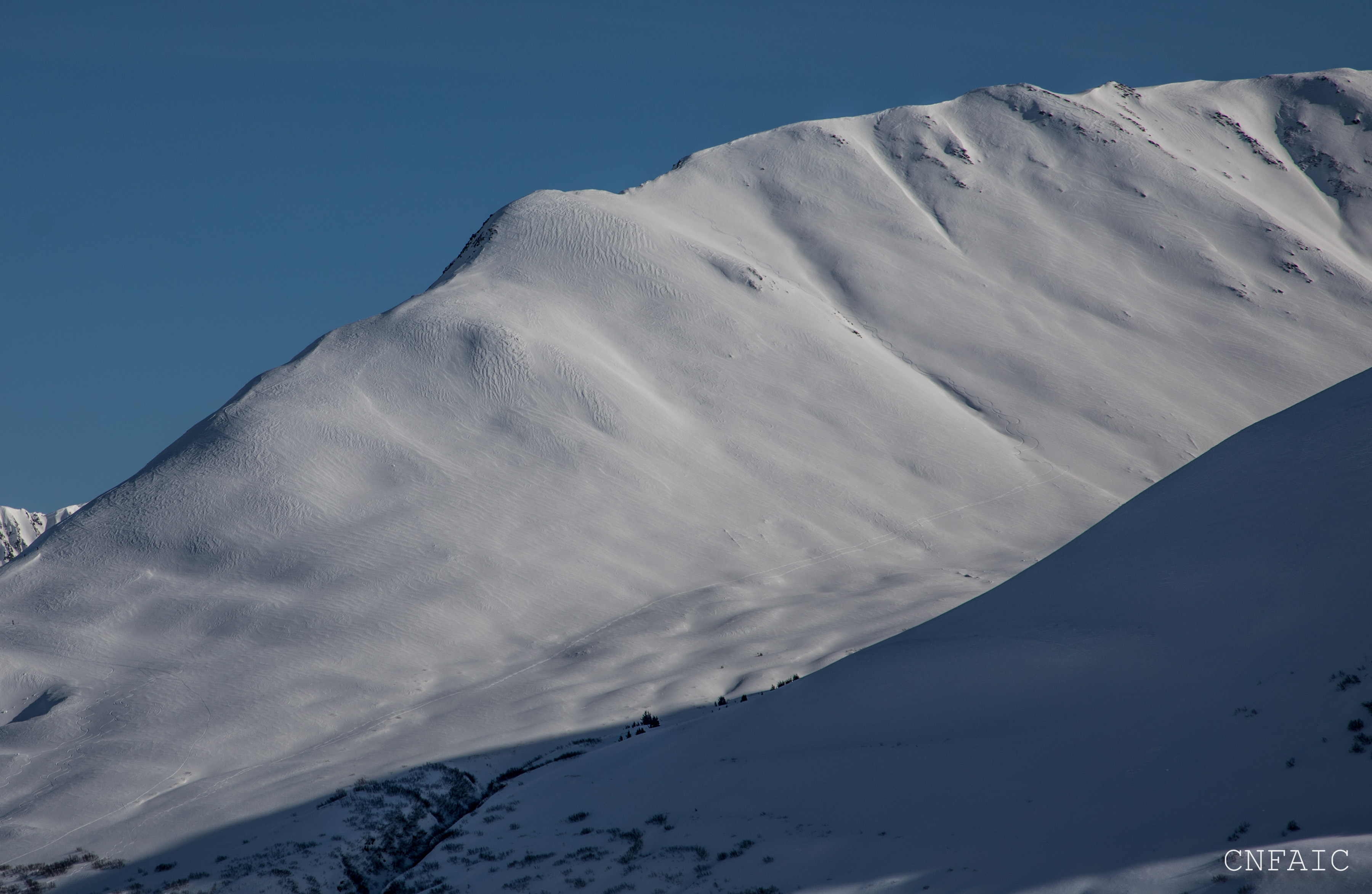
Triggering an avalanche 2+ feet thick is possible due to several weak layers buried within our snowpack. More potential exists on the Southern end of Turnagain Pass and Summit Lake zone where a shallow and weaker snowpack remains. This was evident on Wednesday during the wind event where numerous large avalanches released naturally near Silvertip Creek and in Summit Lake. In Turnagain Pass we have been tracking several weak layers buried 1-2 feet deep (facets and buried surface hoar) and both have been reactive in stability tests. This structure can be found on all aspects and will be easier to trigger in thinner areas of the snowpack. These slabs could be triggered in softer more protected snow or in places where the snow is harder and more supportable. Whumpfing has been reported by several parties this week in the mid elevation band, but so far we are not aware of any human triggered activity in Turnagain Pass. Evaluate the terrain for consequences before committing to a slope. There is still much uncertainty around this avalanche problem.
Deep Persistent Slabs: Keep in mind that there are deeper persistent layers that could ‘wake up’ if you find the wrong spot above 3,000′ in the Alpine. At these high elevations, old weak layers of facets and buried surface hoar sit in the bottom half of the snowpack. This structure is also more pronounced in places with a thin overall snow cover, such as the South end of Turnagain Pass, the Summit Lake area and Crow Pass.
In the treeline zone weak snow (facets) have been reactive in stability tests over the last few weeks. In the upper elevations a layer of buried surface hoar is mixed with facets and is also suspect.
Yesterday was overcast and temperatures average in the 20F’s in the alpine with cooler temps at valley bottoms increasing into the upper 20F’s this morning as low pressure moves into the region. A trace of snow was picked up on a few weather stations. Winds were light from the East (5-15mph) most of the day. Overnight East winds on Seattle Ridge bumped into the 15-20mph range.
Today expect light snow showers in Turnagain Pass and Girdwood and an inch or two of new snow. Skies are expected to be overcast and could start to clear early this evening. Temps at sea level may reach the low 30F’s and temps in alpine will average in the mid 20F’s. Winds should be light 5-15mph from the Southeast, but may pick up into the moderate range this evening.
Tomorrow looks like a period of clearing skies before another low pressure system move into our region Monday evening. Similar to today’s weather this system is also expected to favor Anchorage and Mat-Su. Depending on how far North the low tracks, we may see an uptick in gap winds tomorrow near Coastal areas, but these winds should remain in the Moderate range. Temperatures are expected to be in the 20s F.
Temp Avg (F) | Snow (in) | Water (in) | Snow Depth (in) | |
Center Ridge (1880′) | 23 | 0 | 0 | 69 |
Summit Lake (1400′) | 21 | 0 | 0 | 29 |
Alyeska Mid (1700′) | 23 | trace | .05 | 60 |
Temp Avg (F) | Wind Dir | Wind Avg (mph) | Wind Gust (mph) | |
Sunburst (3812′) | 19 | ESE | 5 | 17 |
Seattle Ridge (2400′) | 22 | E | 10 | 25 |
Date | Region | Location | Observer |
---|---|---|---|
05/22/23 | Turnagain | Avalanche: Tincan | Nick D'Alessio |
05/12/23 | Turnagain | Avalanche: Tincan, Sunburst, Magnum, Cornbiscuit | Heather Thamm |
05/07/23 | Turnagain | Observation: Tincan – Bear Tracks | CNFAIC Staff |
05/05/23 | Turnagain | Observation: Seattle Ridge | AS/ WW Forecaster |
05/02/23 | Turnagain | Observation: Cornbiscuit | Schauer/ Sturgess Forecaster |
05/02/23 | Turnagain | Observation: Seward Hwy Turnagain Pass | Joel Curtis |
04/30/23 | Turnagain | Observation: Magnum | Ayla, Kit Crosby, Barton |
04/29/23 | Turnagain | Observation: Tincan | John Sykes |
04/28/23 | Turnagain | Avalanche: Taylor Pass/Pastoral | Schauer/ Creighton Forecaster |
04/28/23 | Turnagain | Avalanche: Tincan | Andy Moderow |
Status of riding areas across the Chugach NF is managed by the Glacier and Seward Ranger Districts, not avalanche center staff. Riding area information is posted as a public service to our users and updated based on snow depth and snow density to prevent resource damage at trailhead locations. Riding area questions contact: mailroom_r10_chugach@fs.fed.us
Area | Status | Weather & Riding Conditions |
---|---|---|
Glacier District |
Subscribe to Turnagain Pass
Avalanche Forecast by Email
This is a general backcountry avalanche advisory issued for Turnagain Arm with Turnagain Pass as the core advisory area. This advisory does not apply to highways, railroads or operating ski areas.