Turnagain Pass RSS

Archives
ARCHIVED - Forecasts expire after 24 hours.
Issued
Sun, February 5th, 2017 - 7:00AM
Expires
Mon, February 6th, 2017 - 7:00AM
Forecaster
Heather Thamm
Avalanche risk The Bottom Line

The avalanche danger is  MODERATE  in the advisory area including both Turnagain Pass and Girdwood Valley. Above 1000′ triggering a persistent slab avalanche 2-4+ feet deep is possible and  consequences remain high should you find a trigger spot. Two large snowmachine triggered avalanches occured as recently as Friday and both folks involved were uninjured. Heat from the sun will also be something to monitor and could make wind slabs, cornices and loose snow avalanches more tender.  Be sure to  carry your rescue gear and practice safe travel protocol – such as exposing one person at a time, grouping up in safe zones, having escape routes planned and watching your partners!  

Below 1000′  the danger is  LOW,  where temperatures are freezing overnight and a hard crust exists.  

Summit Lake:  An unstable snowpack exists in the Summit Lake area and human triggered avalanches breaking near the ground are possible. Make sure and check the Saturday Summit Summary  HERE.

Special Announcements

The  Southern Kenai Mountains including Seward, Snug Harbor and Lost Lake  continue to have an unstable snowpack.  
Human triggered large avalanches, breaking near the ground, are possible.  
Please see link above for recent activity.  Another 1-2′ of wet heavy snow fell Tuesday and Wednesday, adding more load to a snowpack with weak snow near the base. Keep in mind avalanches can be  triggered remotely, from below or mid-slope.  Careful snowpack evaluation and cautious route-finding is essential.  

Hatcher Pass avalanche conditions: If you are considering heading this way – please check the  recent observations for Hatcher Pass  and the  Saturday morning advisory!

Sun, February 5th, 2017
Alpine
Above 2,500'
2 - Moderate
Avalanche risk
Treeline
1,000'-2,500'
2 - Moderate
Avalanche risk
Below Treeline
Below 1,000'
1 - Low
Avalanche risk
0 - No Rating
1 - Low
2 - Moderate
3 - Considerable
4 - High
5 - Extreme
Avalanche risk Avalanche risk Avalanche risk Avalanche risk Avalanche risk
Travel Advice Generally safe avalanche conditions. Watch for unstable snow on isolated terrain features. Heightened avalanche conditions on specific terrain features. Evaluate snow and terrain carefully; identify features of concern. Dangerous avalanche conditions. Careful snowpack evaluation, cautious route-finding, and conservative decision-making essential. Very dangerous avalanche conditions. Travel in avalanche terrain not recommended. Extraordinarily dangerous avalanche conditions. Avoid all avalanche terrain.
Likelihood of Avalanches Natural and human-triggered avalanches unlikely. Natural avalanches unlikely; human-triggered avalanches possible. Natural avalanches possible; human-triggered avalanches likely. Natural avalanches likely; human-triggered avalanches very likely. Natural and human-triggered avalanches certain.
Avalanche Size and Distribution Small avalanches in isolated areas or extreme terrain. Small avalanches in specific areas; or large avalanches in isolated areas. Small avalanches in many areas; or large avalanches in specific areas; or very large avalanches in isolated areas. Large avalanches in many areas; or very large avalanches in specific areas. Very large avalanches in many areas.
Avalanche Problem 1
  • Deep Persistent Slabs
    Deep Persistent Slabs
Deep Persistent Slabs
Deep Persistent Slab avalanches are the release of a thick cohesive layer of hard snow (a slab), when the bond breaks between the slab and an underlying persistent weak layer deep in the snowpack. The most common persistent weak layers involved in deep, persistent slabs are depth hoar or facets surrounding a deeply buried crust. Deep Persistent Slabs are typically hard to trigger, are very destructive and dangerous due to the large mass of snow involved, and can persist for months once developed. They are often triggered from areas where the snow is shallow and weak, and are particularly difficult to forecast for and manage.
More info at Avalanche.org

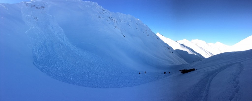
Friday there were two large snowmachine triggered avalanches in our advisory area. One in Seattle Creek where a rider was completely buried except for his hand sticking out.  He was quickly rescued by his party but his sled was not located. In Lynx Creek a snowmachiner triggered a slope just after he crested the hill but was not caught. One of his partners commented, “If I had tried high-marking at the same time as him or right after him I would not have made it outta there.” No obvious signs of instability were observed and in both cases there was already tracks on the slope. 

Both of these avalanches were triggered on an old/weak foundation, facets near the ground. This upside down structure exists in many places across our forecast zone, but not everywhere. Due to the spacial variability of our current snowpack assessing the snow that is across an entire slope is difficult and near impossible. Many folks have been able to snowmachine or ski/ride on a variety of steep terrain without incident over the last few days. This speaks to the uncertainty of our current avalanche problem and the dangers of a stabilizing snowpack. The likelihood of triggering a deep persistent slab is decreasing, but the consiquences remain high should you find the wrong spot. The slab in Seattle Creek was reported to be 4-6′ deep and the avalanche in Lynx 1-3′ deep. This type of avalanche is often triggered in a thin part of the slab, near rocks or on the edge of the slab. These can also be triggered by multiple skiers/boarders and/or snowmachines on, near or under slopes. Remember just because the slope has lots of tracks does not mean the slope is safe. It may be the 3rd or 10th or 25th track that tips the balance. Above freezing temperatures in the Alpine and direct sunshine may also make these slabs easier to initiate.  This is a lot to factor into decision making this weekend, but please keep the following in mind: 

  1. An avalanche on a large open slope may propagate and run further than expected.
  2. Obvious signs like shooting cracks or collapsing “whumpfing” are unlikely today.
  3. Identify safe zones and travel one at a time between islands of safety.
  4. Make a plan and reasses with your partners as you travel. Radios can be very helpful.
  5. Be aware of other groups and if an area becomes too crowded it may not be possible to practice safe travel protocol. Consider going elsewhere. 

Seattle Creek Avalanche that occured on Friday, Feb.3 near the -3 bowl on a NE aspect. Photo courtesy of Brad Larson


This crown in Lynx Creek wraps around the ridge on a Northeast facing slope. Notice the vegitation and places where the ground is exposed. Photo by Mahear Aboueid


The crown of the Lynx Creek avalanche can be seen easily from the Johnson Pass trail head and shows the bigger view of the crown as it wraps around the slope. 


Additional Concern
  • Announcement
    Announcement

In addition to deep persistent slab avalanches there are a few other avalanche concerns to pay attention to today. The sun is out and affecting the snow in terrain on the Southern half of the compass. Warm temperatures and direct sunlight may also play a factor in all of these concerns. Pay attention to changing conditions!

Wind Slabs: Old stubborn wind slabs as well as some newer ones may be triggered on leeward slopes. Look out for pillowed or drifted snow, listened for hollow sounds and avoid areas with stiff snow over soft snow. Warming temperatures and direct sunlight may make these slabs easier to trigger on solar aspects.

Loose snow: With 4-8″ of loose snow on the surface over a dense base, watch your sluffs and watch how the sun is affecting the snow around you. These may pack enough punch to push you somewhere you don’t want to go i.e. a terrain trap. 

Cornices: Yesterday large cracks were reported along the some of the cornices in the back bowls of Seattle Ridge. Cornces are unpredictable hazards and can break farther back onto a ridge than expected and have the potential to trigger an avalanche on the slope below. Give ridge lines extra space – they may have a cornice on the other side. 

Sun triggered roller balls were observed on many South and East facing slopes. 

Weather
Sun, February 5th, 2017

Yesterday a strong inversion caused ridgetop temperatures to reach a high of 43F during the heat of the day and pockets of cold air in valley bottoms were in the single digits. Winds were calm and variable. No precipitation has been recorded in many days.   Overnight ridgetop temperatures have been slowly dropping, but are still hovering around 32F.  

Today the inversion will start to weaken, but upper elevation temps could easily reach the mid 30F’s by mid day. Expect sunny and clear skies with light and variable winds. Over the next few days an arctic air mass is forecasted to shift south over Southcental, Alaska with a chance for single digits later in the week.

PRECIPITATION 24-hour data (6am – 6am)

  Temp Avg (F) Snow (in) Water (in) Snow Depth (in)
Center Ridge (1880′) 29   0   0   53  
Summit Lake (1400′) 17   0   0   23  
Alyeska Mid (1700′)  29 0   0   47  

RIDGETOP 24-hour data (6am – 6am)

  Temp Avg (F) Wind Dir Wind Avg (mph) Wind Gust (mph)
Sunburst (3812′) 39   var.   5   12  
Seattle Ridge (2400′) 36   var.   2   6  
Observations
Recent Observations for Turnagain Pass
Date Region Location
10/27/24 Turnagain Observation: Tincan
10/21/24 Turnagain Observation: Turnagain Pass Road Observation
10/19/24 Turnagain Observation: Tincan – Below Todds Run
10/18/24 Turnagain Observation: Taylor Pass
10/15/24 Turnagain Observation: Tincan Common
10/14/24 Turnagain Avalanche: Tincan
05/13/24 Turnagain Observation: Eddie’s, Sunburst, Seattle, Cornbiscuit, Pete’s South
05/13/24 Turnagain Observation: Turnagain Pass non-motorized side
05/12/24 Turnagain Observation: Warm up Bowl
05/07/24 Turnagain Observation: Turnagain Pass Wet Slabs
Riding Areas

The riding areas page has moved. Please click here & update your bookmarks.


Subscribe to Turnagain Pass
Avalanche Forecast by Email

This is a general backcountry avalanche advisory issued for Turnagain Arm with Turnagain Pass as the core advisory area. This advisory does not apply to highways, railroads or operating ski areas.