Turnagain Pass RSS

Archives
ARCHIVED - Forecasts expire after 24 hours.
Issued
Sat, February 4th, 2017 - 7:00AM
Expires
Sun, February 5th, 2017 - 7:00AM
Forecaster
Aleph Johnston-Bloom
Avalanche risk The Bottom Line

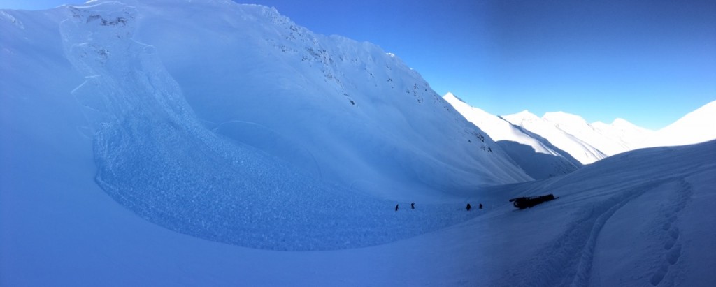
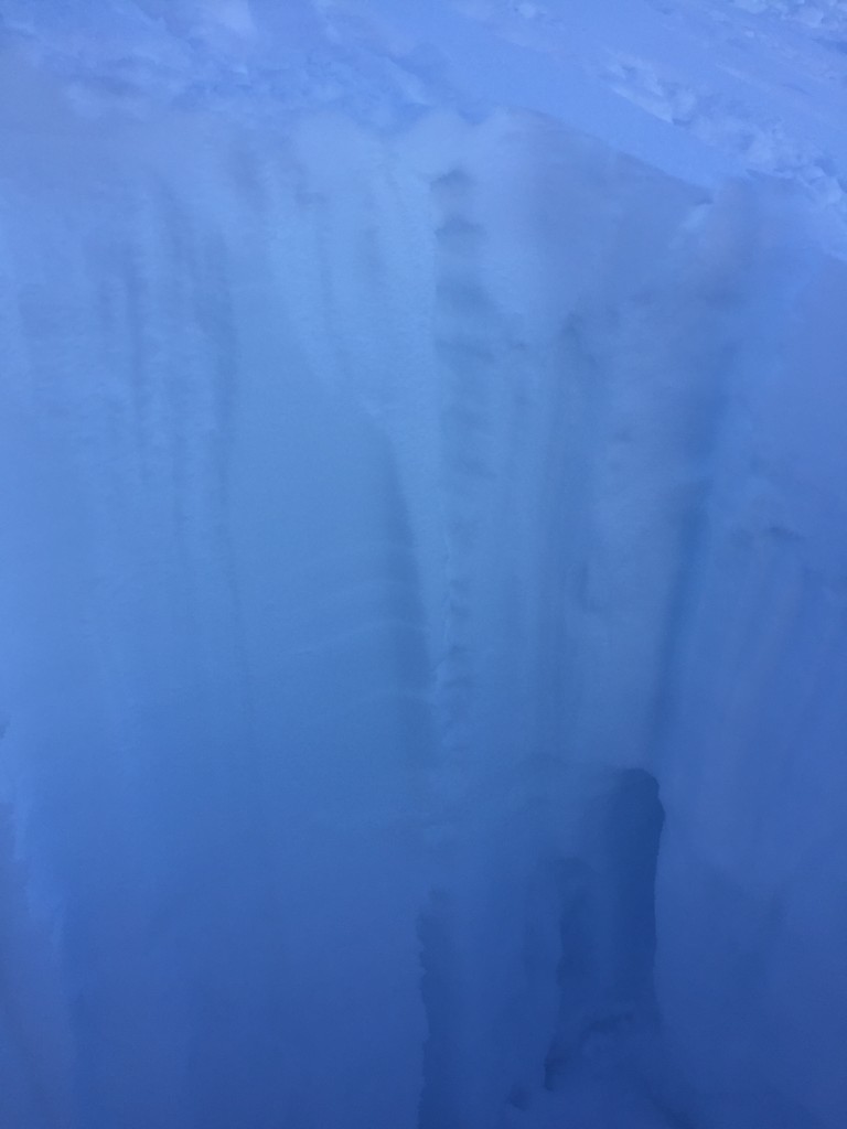
The avalanche danger is  MODERATE  in the advisory area. Above 1000′ on slopes over 30 degrees, triggering a persistent slab avalanche 2-4+ feet deep is possible and  consequences remain high should you find the right trigger spot. Heat from the sun will also be something to monitor and could make wind slabs, cornices and loose snow avalanches more tender.  Be sure to  carry your rescue gear and practice safe travel protocol – such as exposing one person at a time, grouping up in safe zones, having escape routes planned and watching your partners!  

Below 1000′  the danger is  LOW,  where temperatures are freezing overnight and a hard crust exists.  

Summit Lake:  An unstable snowpack exists in the Summit Lake area and human triggered avalanches breaking near the ground are possible. Make sure and check the Saturday Summit Summary  HERE.

Special Announcements

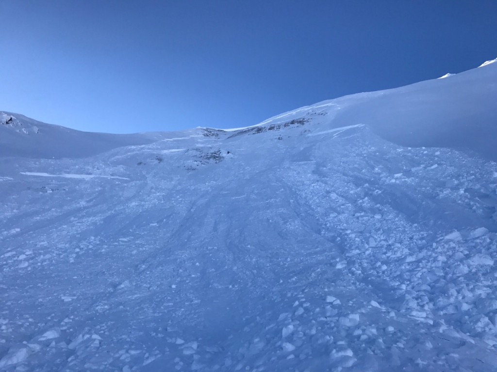
The  Southern Kenai Mountains including Seward, Snug Harbor and Lost Lake  continue to have an unstable snowpack.  
Human triggered large avalanches, breaking near the ground, are possible.  
Please see link above for recent activity.  Another 1-2′ of wet heavy snow fell Tuesday and Wednesday, adding more load to a snowpack with weak snow near the base. Keep in mind avalanches can be  triggered remotely, from below or mid-slope.  Careful snowpack evaluation and cautious route-finding is essential.  

Placer and Twenty Mile:  Travel is extremely difficult right now due to recent rain, warm temperatures and overflow. This area will remain open in anticipation of forecasted cooler temps but travel is NOT currently recommended for novice riders.

Hatcher Pass avalanche conditions: If you are considering heading this way – please check the  recent observations for Hatcher Pass  and the  Saturday morning advisory!

Sat, February 4th, 2017
Alpine
Above 2,500'
2 - Moderate
Avalanche risk
Treeline
1,000'-2,500'
2 - Moderate
Avalanche risk
Below Treeline
Below 1,000'
1 - Low
Avalanche risk
0 - No Rating
1 - Low
2 - Moderate
3 - Considerable
4 - High
5 - Extreme
Avalanche risk Avalanche risk Avalanche risk Avalanche risk Avalanche risk
Travel Advice Generally safe avalanche conditions. Watch for unstable snow on isolated terrain features. Heightened avalanche conditions on specific terrain features. Evaluate snow and terrain carefully; identify features of concern. Dangerous avalanche conditions. Careful snowpack evaluation, cautious route-finding, and conservative decision-making essential. Very dangerous avalanche conditions. Travel in avalanche terrain not recommended. Extraordinarily dangerous avalanche conditions. Avoid all avalanche terrain.
Likelihood of Avalanches Natural and human-triggered avalanches unlikely. Natural avalanches unlikely; human-triggered avalanches possible. Natural avalanches possible; human-triggered avalanches likely. Natural avalanches likely; human-triggered avalanches very likely. Natural and human-triggered avalanches certain.
Avalanche Size and Distribution Small avalanches in isolated areas or extreme terrain. Small avalanches in specific areas; or large avalanches in isolated areas. Small avalanches in many areas; or large avalanches in specific areas; or very large avalanches in isolated areas. Large avalanches in many areas; or very large avalanches in specific areas. Very large avalanches in many areas.
Avalanche Problem 1
  • Deep Persistent Slabs
    Deep Persistent Slabs
Deep Persistent Slabs
Deep Persistent Slab avalanches are the release of a thick cohesive layer of hard snow (a slab), when the bond breaks between the slab and an underlying persistent weak layer deep in the snowpack. The most common persistent weak layers involved in deep, persistent slabs are depth hoar or facets surrounding a deeply buried crust. Deep Persistent Slabs are typically hard to trigger, are very destructive and dangerous due to the large mass of snow involved, and can persist for months once developed. They are often triggered from areas where the snow is shallow and weak, and are particularly difficult to forecast for and manage.
More info at Avalanche.org

Yesterday the weak facets near the base of the snowpack showed their teeth and two snowmachiners had very close calls.  On the Seattle Creek Headwall a slope (that had been previously high marked and skied) was triggered just as the as snowmachiner that climbed it turned to travel back down. The rider tried to pull his airbag but was unsuccessful and was completely buried except for a hand sticking out.  He was quickly rescued by his party but his sled was not located.  In Lynx Creek a snowmachiner triggered a slope just after he crested the hill but was not caught. Snowmachiners in both locations remarked that there were no signs that the snowpack was unstable and in both cases there was already tracks on the slope. Many other skiers and riders enjoyed the mountains yesterday without incident. All these factors are characteristic of deep persistent slab, low probability of triggering but high consequences if you do find the wrong spot. The slab in Seattle Creek was reported to be 4-6′ deep and the avalanche in Lynx 1-3′ deep. This type of avalanche is often triggered in a thin part of the slab, near rocks or on the edge of the slab. These can also be triggered by multiple skiers/boarders and/or snowmachines on, near or under slopes. It may be the 3rd or 10th or 25th track that tips the balance. Observers have found weak faceted snow at the base of the snowpack across the area from Seward to Girdwood. However, another tricky part of the equation is that although this set-up is fairly widespread it is also variable making some slopes safe to ride and others very dangerous. The take away from the avalanches yesterday is that weak snow with a deep slab on top is poor snowpack structure and may remain suspect for days to come. Temperatures above freezing in the Alpine and direct sunshine may also make these slabs more easy to initiate.  All of this has to be a factor in decision making this weekend.  Remember signs of instability are not always present and slabs may break once you are well out onto them. As always practice safe travel protocols, be aware of other parties in the area, choose terrain wisely, carry rescue equipment and don’t let the sunshine cloud your judgment. 

Seattle Creek avalanche. Photos: Chad Aurentz

Lynx Creek avalanche. Photos: Mark Guess

Snowpack near the Lynx Creek avalanche shows hard snow over soft weak snow near the ground. Photo: Travis Rupp


Additional Concern
  • Announcement
    Announcement

In addition to deep persistent slab avalanches there are a few other avalanche concerns to pay attention to today. All of these concerns could be a hazard seperately or once initiated, trigger a larger persistent slab deeper in the snowpack. Warm temperatures and direct sunlight may also play a factor in all of these concerns. We have reached the time of year. The sun is out and affecting the snow in terrain on the Southern half of the compass. A small crust was observed forming on Thurday on steep southerly slopes. Pay attention to changing conditions!

Wind Slabs: Old stubborn wind slabs may be triggered on leeward slopes. Looked for pillowed or drifted snow, listened for hollow sounds and avoid areas with stiff snow over soft snow. Warming temperatures and direct sunlight may make these slabs easier to trigger.

Loose snow: With 4-8″ of loose snow on the surface over a dense base, watch your sluffs and watch how the sun is affecting the snow around you. These may pack enough punch to push you somewhere you don’t want to go i.e. a terrain trap. 

Cornices: Give cornices wide berth, avoid travel on slopes below them and remember they can break farther back onto the ridge than expected.  If cornices do break and fall they could trigger an avalanche on the slope below. 

Weather
Sat, February 4th, 2017

Yesterday was warm in the Alpine with temperatures reaching the 40Fs on some weather stations. Skies were clear and winds were light and variable. Valley fog moved out in the mid morning. Overnight the inversion kept temperatures cold in the valley bottoms with some areas seeing teens and single digits. Temperatures in stayed above freezing at higher elevations.

Today will be warm, temperatures are already in the 40s in the Alpine. Skies will be mostly clear and winds will be calm. The weather looks to be similar into early next week  as a “high latitude blocking pattern remains firmly entrenched over  mainland Alaska.” Cooler temperatures and a chance for precipitation are a possibility by mid week! Stay tuned.  

PRECIPITATION 24-hour data (6am – 6am)

  Temp Avg (F) Snow (in) Water (in) Snow Depth (in)
Center Ridge (1880′) 25   0    0 54  
Summit Lake (1400′) 14    0  0  23
Alyeska Mid (1700′)  23  0  0 48  

RIDGETOP 24-hour data (6am – 6am)

  Temp Avg (F) Wind Dir Wind Avg (mph) Wind Gust (mph)
Sunburst (3812′)  39  ENE  5 11  
Seattle Ridge (2400′)  31  variable  3  7
Observations
Recent Observations for Turnagain Pass
Date Region Location
03/28/24 Turnagain Observation: Sunburst
03/27/24 Turnagain Observation: Tincan Trees
03/26/24 Turnagain Observation: Cornbiscuit
03/25/24 Turnagain Observation: Tincan
03/22/24 Turnagain Avalanche: Magnum Northwest Aspect
03/21/24 Turnagain Observation: Sunburst
03/21/24 Turnagain Observation: Tincan Proper North Aspect
03/20/24 Turnagain Avalanche: Seattle Creek Drainage
03/19/24 Turnagain Observation: Tincan CFR
03/18/24 Turnagain Avalanche: Tincan – Eddies – Seattle Ridge
Riding Areas

The riding areas page has moved. Please click here & update your bookmarks.


Subscribe to Turnagain Pass
Avalanche Forecast by Email

This is a general backcountry avalanche advisory issued for Turnagain Arm with Turnagain Pass as the core advisory area. This advisory does not apply to highways, railroads or operating ski areas.