Turnagain Pass
|
![]() ![]() |
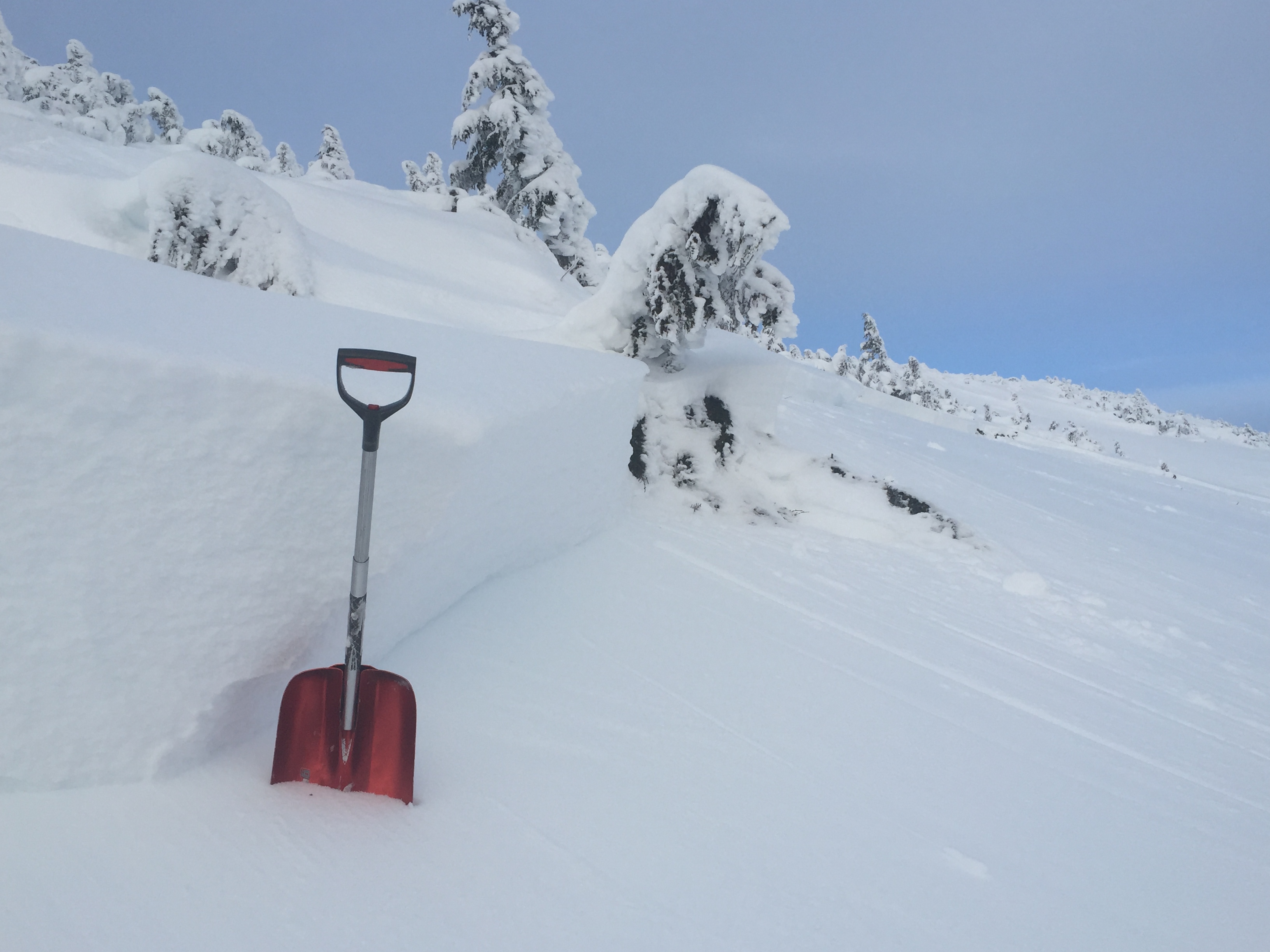
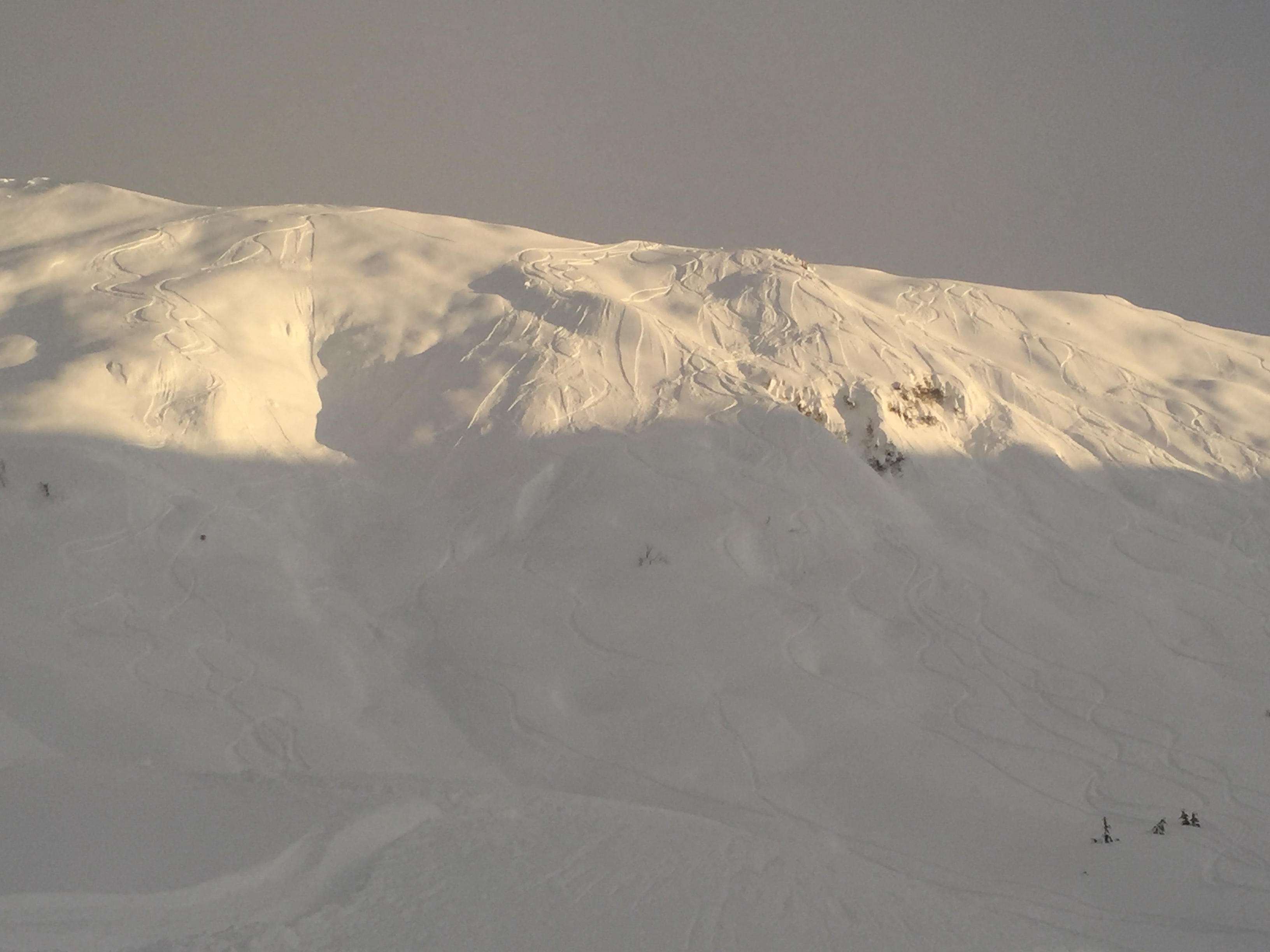
The avalanche danger is MODERATE at and above treeline in the backcountry surrounding Turnagain pass. Pockets of lingering wind slabs 1-3′ deep will be possible to trigger after a quick but intense storm dropped 2+ feet of snow on Saturday in the core advisory area. Obvious red flags may be absent today as wind slabs are overlain by 1-2′ of soft, unconsolidated snow in many areas. Additional avalanche concerns today include loose snow, cornices and glide cracks.
Below treeline the danger is LOW where there has been less snow and less wind.
Looking for a special Christmas gift? Pick up a F-CNFAIC raffle ticket! Awesome prizes from our sponsors at Alaska Airlines, Alyeska Resort, Chugach Powder Guides, Talkeetna Air Taxi and Ortovox. Drawing to be held Feb 26th at TapRoot. Contact the Friends group through Facebook if you’re interested!
The Chugach National Forest has opened Johnson Pass trailheads (North and South) to motorized use as of today. Please see the “Riding Areas” table at the bottom of this page for current info on areas open to snowmachines.
![]() |
![]() |
![]() |
![]() |
![]() |
|
Travel Advice | Generally safe avalanche conditions. Watch for unstable snow on isolated terrain features. | Heightened avalanche conditions on specific terrain features. Evaluate snow and terrain carefully; identify features of concern. | Dangerous avalanche conditions. Careful snowpack evaluation, cautious route-finding, and conservative decision-making essential. | Very dangerous avalanche conditions. Travel in avalanche terrain not recommended. | Extraordinarily dangerous avalanche conditions. Avoid all avalanche terrain. |
Likelihood of Avalanches | Natural and human-triggered avalanches unlikely. | Natural avalanches unlikely; human-triggered avalanches possible. | Natural avalanches possible; human-triggered avalanches likely. | Natural avalanches likely; human-triggered avalanches very likely. | Natural and human-triggered avalanches certain. |
Avalanche Size and Distribution | Small avalanches in isolated areas or extreme terrain. | Small avalanches in specific areas; or large avalanches in isolated areas. | Small avalanches in many areas; or large avalanches in specific areas; or very large avalanches in isolated areas. | Large avalanches in many areas; or very large avalanches in specific areas. | Very large avalanches in many areas. |
A skier-triggered avalanche reported yesterday and a snowmachine-triggered avalanche on Sunday point toward a snowpack that still warrants caution and respect. Wind slabs 1-3’ in depth that formed early in this last storm cycle (Saturday Dec. 19th) resting on weak snow from early December are the suspected culprits. As winds died down on Saturday afternoon with the storm, these slabs are masked below 6-18” of soft, surface snow in places. With a lot of traffic in the backcountry over the last 2 days and good visibility (to view lots of terrain), this doesn’t appear to be a widespread problem; rather it’s pockets of instabilities waiting for a trigger. With this kind of avalanche problem safe travel practices will again be a key way to manage any uncertainties as we move in to a period of high pressure. Watching your partners, having an escape route planned, grouping up in safe zones and carry and know how to use your avalanche rescue gear will be paramount for a safe holiday season in the backcountry.
We still lack information from the periphery areas such as the Girdwood Valley, Summit Lake and now Johnson Pass/ Lynx Creek (open to snowmachines today). Generally these areas have a shallower snowpack than Turnagain pass and can potentially harbor more weak snow. If you are out and about in these zones today please consider submitting a quick observation or even just a photo or two here.
Close-up look at the crown face of a snowmachine-triggered wind slab avalanche from Sunday. More details here.
For folks pushing in to steeper terrain today, you can expect to deal with fast moving, low to medium volume loose snow avalanches (sluffing). As temps drop and the surface becomes more unconsolidated, these will grow in size. Usually manageable if anticipated, this is an avalanche problem that can knock a skier off their feet in steep, unforgiving terrain but is unlikely to bury a person.
Lots of loose snow sluffing initiated by skiers can be seen in the fading solstice light yesterday on Widow Maker.
Cornices have grown a fair bit from Saturday’s storm. As we enter a several day stretch of mostly clear weather and folks are traveling further into the backcountry, don’t forget to give these features a wide berth! There are at least a couple of suspected cornice failures yesterday both on the Tincan ridge and the Sunburst ridge, likely from folks simply walking too close to the edge.
Glide cracks: Really, glide cracks?? We observed a new (in the last few days) glide crack opening up looker left of Widow Maker on the back side of Seattle ridge. As with cornices, give these features a wide berth as they are akin to the really drunk guy at the holiday party: Unpredictable!
Recent glide crack observed on the backside of Seattle ridge in Main bowl.
Valley fog lifted early giving way to high clouds and mostly sunny skies by yesterday’s solstice sunset (3:42PM). Winds were light and variable with temps comfortably in the teens.
Along with a 2 second increase in daylight today, we can expect almost a carbon copy of yesterday’s weather. Valley fog should burn off rather quickly with light winds from the NW in the 5-15mph range. Temperatures will be in the teens at ridgetop locations and slightly cooler (single digits) in cold sink areas such as Summit Lake and Granite campground area. No new precipitation is expected today.
Looking out a few days, souchcentral AK will be under high pressure (cold and clear) at least through Christmas eve with a chance of unsettled weather moving into the region on Christmas day.
Temp Avg (F) | Snow (in) | Water (in) | Snow Depth (in) | |
Center Ridge (1880′) | 16 | 0 | 0 | 53 |
Summit Lake (1400′) | 4 | 0 | 0 | 18 |
Alyeska Mid (1700′) | 18 | 0 | 0 | 36 |
Temp Avg (F) | Wind Dir | Wind Avg (mph) | Wind Gust (mph) | |
Sunburst (3812′) | 15 | variable | 3* | 10* |
Seattle Ridge (2400′) | 15 | NW* | 3* | 15* |
*Both weather stations had periods of inoperable wind data yesterday.
Date | Region | Location | Observer |
---|---|---|---|
10/27/24 | Turnagain | Observation: Tincan | Michael Kerst |
10/21/24 | Turnagain | Observation: Turnagain Pass Road Observation | Trevor Clayton |
10/19/24 | Turnagain | Observation: Tincan – Below Todds Run | Andy Moderow |
10/18/24 | Turnagain | Observation: Taylor Pass | Eli Neuffer |
10/15/24 | Turnagain | Observation: Tincan Common | John Sykes Forecaster |
10/14/24 | Turnagain | Avalanche: Tincan | CNFAC Staff |
05/13/24 | Turnagain | Observation: Eddie’s, Sunburst, Seattle, Cornbiscuit, Pete’s South | H Thamm |
05/13/24 | Turnagain | Observation: Turnagain Pass non-motorized side | Amy Holman |
05/12/24 | Turnagain | Observation: Warm up Bowl | Tony Naciuk |
05/07/24 | Turnagain | Observation: Turnagain Pass Wet Slabs | A S |
The riding areas page has moved. Please click here & update your bookmarks.
Subscribe to Turnagain Pass
Avalanche Forecast by Email