Turnagain Pass Avalanche Forecast
|
![]() ![]() |
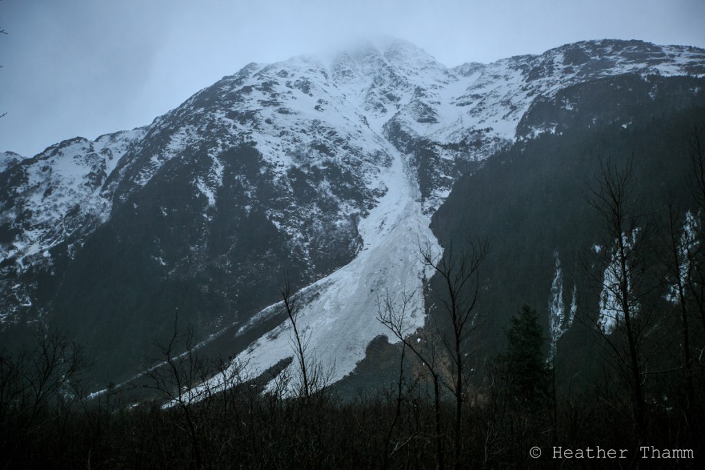
CONSIDERABLE avalanche danger exists both in the Alpine and at Treeline. Due to a four day rain event wet saturated snow up to 3′ thick could be triggered below 2500′. At higher elevations heavy snow is sitting on top of cold weak snow below making it possible to trigger a large slab avalanche up to 4′ thick on all aspects. Avoid steep slopes and high consiquence terrain features. Careful snowpack evaluation, cautious route finding and conservative decision-making are essential skills if venturing into the mountains today.
No Rating below Treeline (below 1000′) means there is currently not enough snow to produce an avalanche at this elevation band.
DANGEROUS AVALANCHE CONDITIONS REMAIN IN MANY AREAS around Southcentral Alaska.
Due to high avalanche danger the East Hatcher Pass Management Area is closed to public use until further notice. For current information visit DNR Newsroom and hatcherpassavalanchecenter.org
The search for a missing skier in Hatcher pass continues today. Click HERE for latest media release from the Hatcher Pass Avalanche Center.
An avalanche was reported yesterday near Anchorage in the Front Range on the Powerline Pass trail. Limited information is known at this time, but warrents extra caution on all hiking trails near steep terrain in Southcentral Alaska. Click here for observation and photos.
Over the last three days 4″ of water fell in the form of rain at lower elevations in Turnagain Pass. Rain/snow line fluctuated between 1800’ and 2500’ leaving the snow saturated with water. Several large wet avalanches were observed along the Seward Highway and Portage Valley over the last two days. Warm temperatures will persist today making it possible to trigger a wet avalanche on steep terrain features. Avoid this hazard by choosing low angle terrain away from large slopes and terrain traps.
*If temperatures drop below freezing this concern will stabilize quickly as water drains and the slab strengthens in the mid elevation zone.
Debris from a wet avalanche in Portage Valley. This avalanche likely released on the morning of Nov.27th.
Strong Northeast winds topped out at 109 mph on Sunburst weather station yesterday morning. Windslabs over 4’ thick on leeward aspects and crossloaded terrain features are a concern for today in the upper elevation zone. Avoid smooth pillow shaped snow on steep slopes and convexities. Even small features if steep enough could break well above you and have plenty of volume to bury a person. Obvious clues like shooting cracks and whumpfing sounds may not be present today making this avalanche problem difficult to identify.
In the upper Alpine above 2500’ weak faceted snow that formed during a cold snap has been covered up by 4’ of heavy snow creating an upside down snowpack. Last week observations showed a large variation in the distribution of this weaker snow below. It is likely that Northern aspects will harbor the bulk of this problem, but until more information is gathered much uncertainty exists as to how well this new snow has bonded with the older less stable snow below it. This is just one more high consequence reason to avoid steep terrain today.
A very wet and warm storm passed through Southcentral Alaska leaving the region with above freezing temperatures and high-sustained winds for multiple days. In Turnagain Pass rain/snow line reached 2500′, Easterly ridgetop winds maxed out above 100mph and 4 € of water fell over a three-day period.
Showery weather in the form of mixed rain and snow is expected today and into the weekend with rain/snow line moving to 1000′. Temperatures will hover just above freezing (32F) and begin to cool slightly by this evening. Easterly ridgetop winds 20-30mph are also expected to depreciate by early evening. This pattern will continue through the weekend with patches of clear sky at times.
*Seattle Wx Station wind data is currently not available.
Temp Avg (F) | Snow (in) | Water (in) | Snow Depth (in) | |
Center Ridge (1880′) | 32F | 0 | 1.4 | 25 |
Summit Lake (1400′) | 33F | 0 | 0.2 | 10 |
Alyeska Mid (1700′) | 34F | 0 | 2.0 | 13.5 |
Temp Avg (F) | Wind Dir | Wind Avg (mph) | Wind Gust (mph) | |
Sunburst (3812′) | 26F | NE | 23 | 98 |
Seattle Ridge (2400′) | 28F | *N/A | *N/A | *N/A |
Date | Region | Location | Observer |
---|---|---|---|
05/22/23 | Turnagain | Avalanche: Tincan | Nick D'Alessio |
05/12/23 | Turnagain | Avalanche: Tincan, Sunburst, Magnum, Cornbiscuit | Heather Thamm |
05/07/23 | Turnagain | Observation: Tincan – Bear Tracks | CNFAIC Staff |
05/05/23 | Turnagain | Observation: Seattle Ridge | AS/ WW Forecaster |
05/02/23 | Turnagain | Observation: Cornbiscuit | Schauer/ Sturgess Forecaster |
05/02/23 | Turnagain | Observation: Seward Hwy Turnagain Pass | Joel Curtis |
04/30/23 | Turnagain | Observation: Magnum | Ayla, Kit Crosby, Barton |
04/29/23 | Turnagain | Observation: Tincan | John Sykes |
04/28/23 | Turnagain | Avalanche: Taylor Pass/Pastoral | Schauer/ Creighton Forecaster |
04/28/23 | Turnagain | Avalanche: Tincan | Andy Moderow |
Status of riding areas across the Chugach NF is managed by the Glacier and Seward Ranger Districts, not avalanche center staff. Riding area information is posted as a public service to our users and updated based on snow depth and snow density to prevent resource damage at trailhead locations. Riding area questions contact: mailroom_r10_chugach@fs.fed.us
Area | Status | Weather & Riding Conditions |
---|---|---|
Glacier District |
Subscribe to Turnagain Pass
Avalanche Forecast by Email
This is a general backcountry avalanche advisory issued for Turnagain Arm with Turnagain Pass as the core advisory area. This advisory does not apply to highways, railroads or operating ski areas.