Turnagain Pass RSS

Archives
ARCHIVED - Forecasts expire after 24 hours.
Issued
Sat, December 25th, 2021 - 7:00AM
Expires
Sun, December 26th, 2021 - 7:00AM
Forecaster
John Sykes
Avalanche risk The Bottom Line

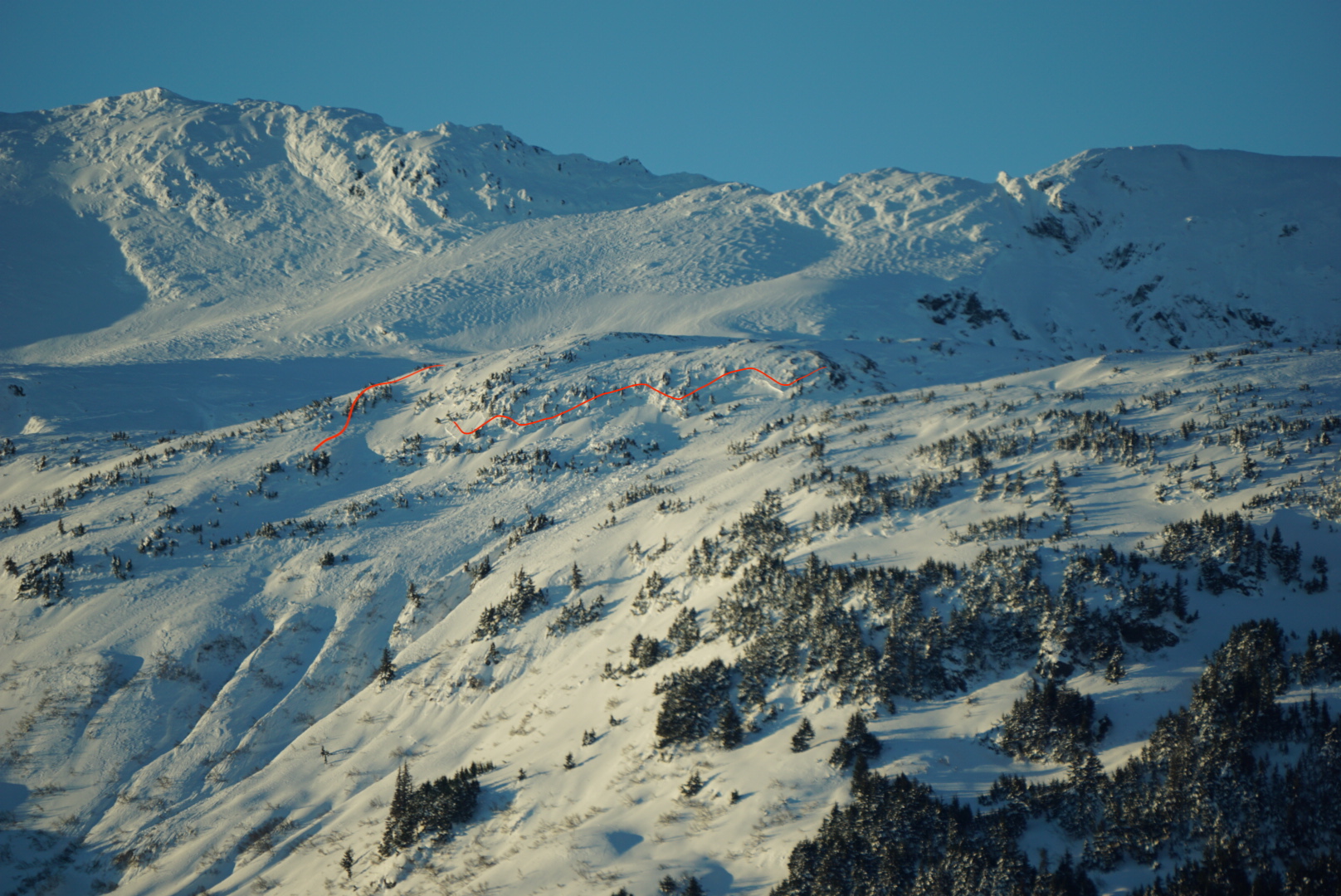
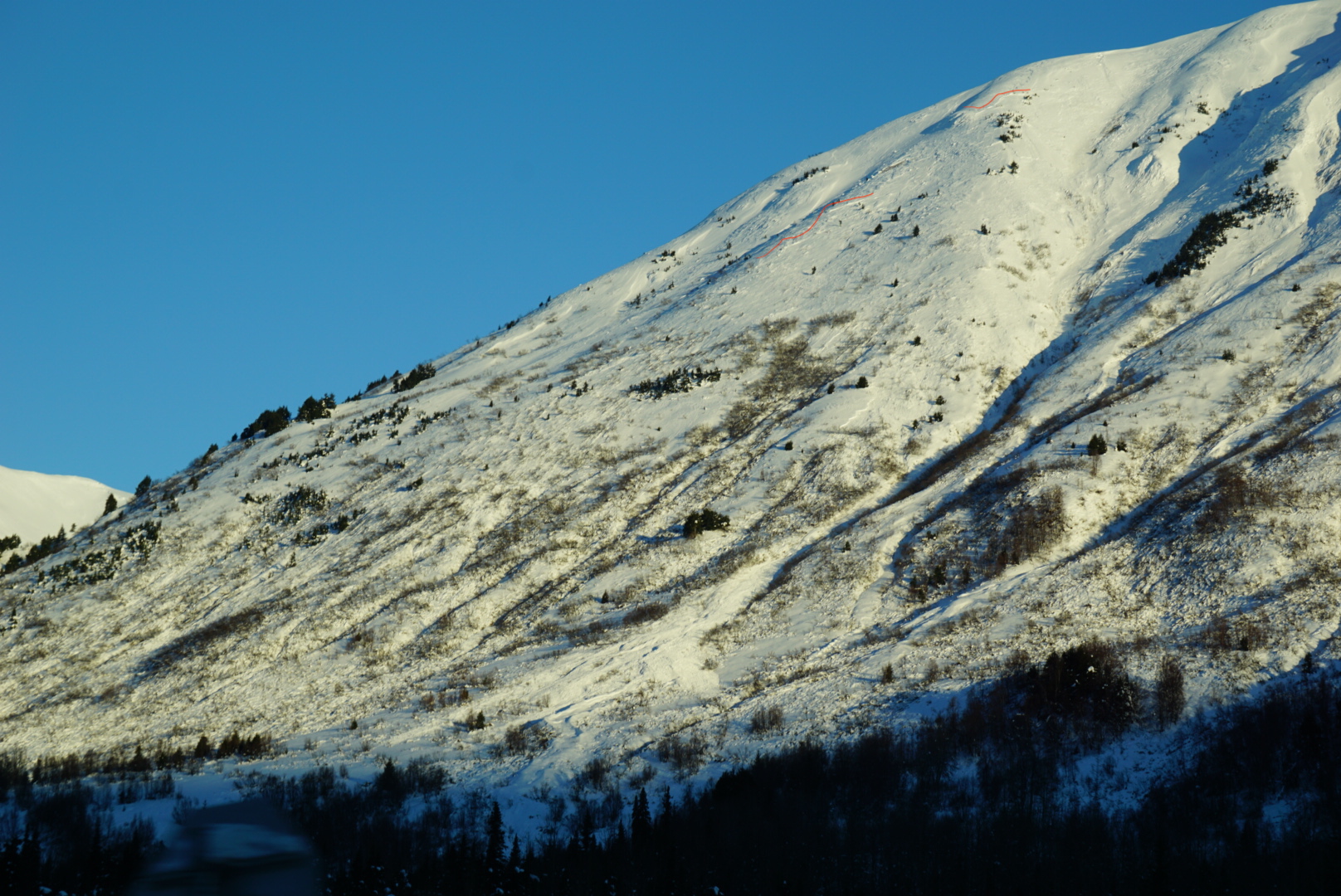
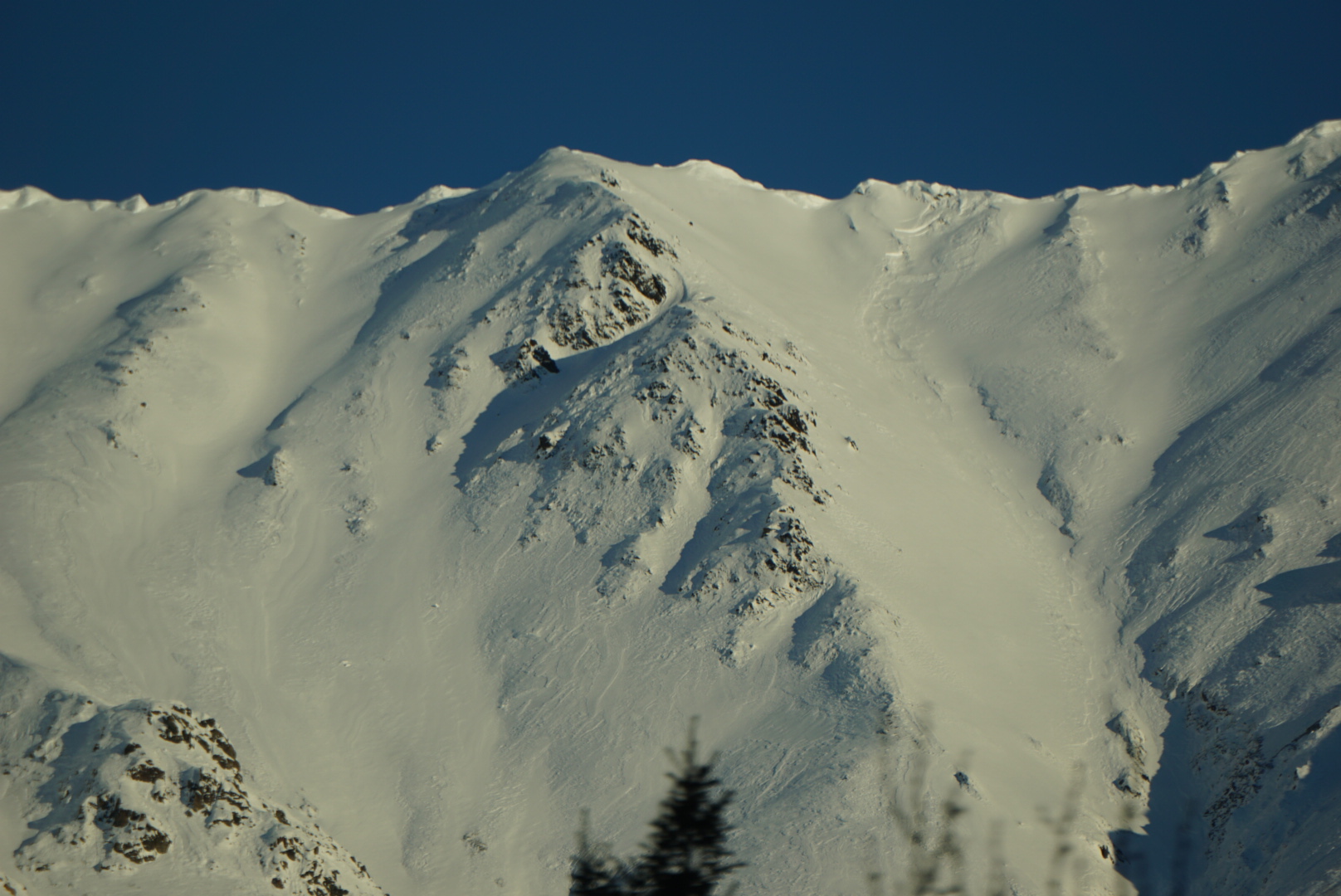
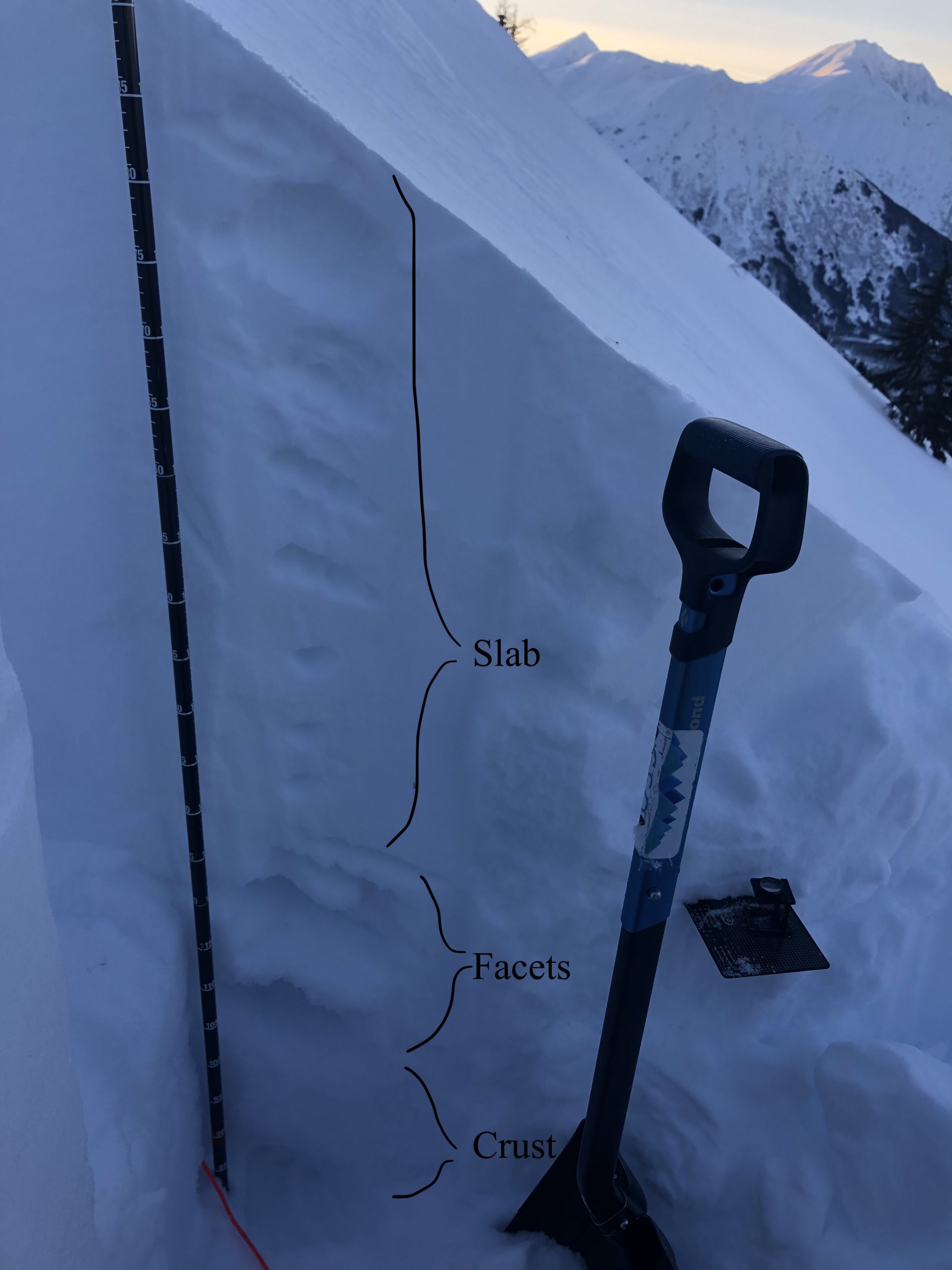
The avalanche danger is MODERATE above 1000′. It will be possible to trigger avalanches 1-2′ deep in areas that saw wind loading over the past two days. Strong winds out of the northwest on 12.23 and 12.24 have created sensitive conditions on a variety of aspects and elevations. Evaluate terrain carefully, especially on common wind loaded features such as gullies, and below convexities and ridgelines. It is also possible that a smaller avalanche or a person could trigger a deeper avalanche on a layer of old sugary faceted snow 2-5′ deep. This will be more likely in areas with a thinner snowpack where the weak layer is closer to surface and easier to trigger.

Below 1000′ the avalanche danger is LOW, where it is unlikely to trigger an avalanche.

ROOF AVALANCHES: With warming temps and potential for liquid precipitation over the next few days be aware of the potential for roof avalanches. These can release spontaneously and be very dangerous if you are standing underneath. They are more common during periods of warm weather and when water lubricates the snowpack between the roofing and base of the snow

Special Announcements
  • Chugach State Park: Some recent observations (here, here, here) have shown that a buried weak layer is producing avalanches after multiple people have already traveled on a slope.
  • Hatcher Pass: Dangerous conditions – Check the Avalanche Forecast here
Sat, December 25th, 2021
Alpine
Above 2,500'
2 - Moderate
Avalanche risk
Treeline
1,000'-2,500'
2 - Moderate
Avalanche risk
Below Treeline
Below 1,000'
1 - Low
Avalanche risk
0 - No Rating
1 - Low
2 - Moderate
3 - Considerable
4 - High
5 - Extreme
Avalanche risk Avalanche risk Avalanche risk Avalanche risk Avalanche risk
Travel Advice Generally safe avalanche conditions. Watch for unstable snow on isolated terrain features. Heightened avalanche conditions on specific terrain features. Evaluate snow and terrain carefully; identify features of concern. Dangerous avalanche conditions. Careful snowpack evaluation, cautious route-finding, and conservative decision-making essential. Very dangerous avalanche conditions. Travel in avalanche terrain not recommended. Extraordinarily dangerous avalanche conditions. Avoid all avalanche terrain.
Likelihood of Avalanches Natural and human-triggered avalanches unlikely. Natural avalanches unlikely; human-triggered avalanches possible. Natural avalanches possible; human-triggered avalanches likely. Natural avalanches likely; human-triggered avalanches very likely. Natural and human-triggered avalanches certain.
Avalanche Size and Distribution Small avalanches in isolated areas or extreme terrain. Small avalanches in specific areas; or large avalanches in isolated areas. Small avalanches in many areas; or large avalanches in specific areas; or very large avalanches in isolated areas. Large avalanches in many areas; or very large avalanches in specific areas. Very large avalanches in many areas.
Recent Avalanches

With good visibility yesterday we were able to see some avalanches that released during the latest round of winds from 12.23 to 12.24 (see observation here and here).

  • NE shoulder of Wolverine

Fresh looking crowns from treeline and alpine elevations, likely caused by wind loading. It is hard to tell how deep these crowns are, but the propagation looks wider than normal for a wind slab, which may indicate that they ran on some kind of buried weak layer. Photo 12.24.21

  • Southern end of Seattle Ridge

Small windslabs in treeline elevation band. Photo 12.24.21

  • Near peak 4650 – NW of 4940 above Sixmile Creek

Wind slab underneath ridgeline in the alpine elevation band. Photo 12.24.21

  • California Creek in Girdwood

The observer thought that a smaller avalanche (red line) might have stepped down onto the faceted layer to produce a larger avalanche (crown below red line). Photo Mike Welch 12.24.21

Avalanche Problem 1
  • Wind Slabs
    Wind Slabs
  • Certain
    Very Likely
    Likely
    Possible
    Unlikely
    Likelihood
  • Historic (D4-5)
    Very Large (D3)
    Large (D2)
    Small (D1)
    Size
Wind Slabs
Wind Slab avalanches are the release of a cohesive layer of snow (a slab) formed by the wind. Wind typically transports snow from the upwind sides of terrain features and deposits snow on the downwind side. Wind slabs are often smooth and rounded and sometimes sound hollow, and can range from soft to hard. Wind slabs that form over a persistent weak layer (surface hoar, depth hoar, or near-surface facets) may be termed Persistent Slabs or may develop into Persistent Slabs.

Likelihood of Avalanches
Terms such as "unlikely", "likely", and "certain" are used to define the scale, with the chance of triggering or observing avalanches increasing as we move up the scale. For our purposes, "Unlikely" means that few avalanches could be triggered in avalanche terrain and natural avalanches are not expected. "Certain" means that humans will be able to trigger avalanches on many slopes, and natural avalanches are expected.

Size of Avalanches
Avalanche size is defined by the largest potential avalanche, or expected range of sizes related to the problem in question. Assigned size is a qualitative estimate based on the destructive classification system and requires specialists to estimate the harm avalanches may cause to hypothetical objects located in the avalanche track (AAA 2016, CAA 2014). Under this schema, "Small" avalanches are not large enough to bury humans and are relatively harmless unless they carry people over cliffs or through trees or rocks. Moving up the scale, avalanches become "Large" enough to bury, injure, or kill people. "Very Large" avalanches may bury or destroy vehicles or houses, and "Historic" avalanches are massive events capable of altering the landscape.

Signal Word Size (D scale) Simple Descriptor
Small 1 Unlikely to bury a person
Large 2 Can bury a person
Very Large 3 Can destroy a house
Historic 4 & 5 Can destroy part or all of a village
More info at Avalanche.org

Merry Christmas and Happy Holidays!!!

The winds have finally died down today, but have left us some ‘gifts’ dispersed throughout the mountains. The main concern today is triggering a lingering wind slab 1-2′ deep that was created during the wind event from 12.23 and 12.24. With good visibility yesterday we were able to see some recent avalanche activity from across the forecast zone which indicates that wind slabs are distributed on a wide variety of aspects and elevations. Some of the recent avalanches may have stepped down into a deeper layer of buried facets 2-5′ deep (see problem 2 for details). To identify wind loaded areas look for signs of wind transport on the snow surface like cornices and wind scouring. Evaluate wind loaded terrain carefully and be aware that stiff wind slabs can support the weight of a skier or rider, allowing you to get out onto the slope before releasing above you. This type of hard wind slab is most likely in areas that saw stronger winds the past two days, such as at higher elevations, near a mountain pass, and along ridgelines.

Avalanche Problem 2
  • Deep Persistent Slabs
    Deep Persistent Slabs
  • Certain
    Very Likely
    Likely
    Possible
    Unlikely
    Likelihood
  • Historic (D4-5)
    Very Large (D3)
    Large (D2)
    Small (D1)
    Size
Deep Persistent Slabs
Deep Persistent Slab avalanches are the release of a thick cohesive layer of hard snow (a slab), when the bond breaks between the slab and an underlying persistent weak layer deep in the snowpack. The most common persistent weak layers involved in deep, persistent slabs are depth hoar or facets surrounding a deeply buried crust. Deep Persistent Slabs are typically hard to trigger, are very destructive and dangerous due to the large mass of snow involved, and can persist for months once developed. They are often triggered from areas where the snow is shallow and weak, and are particularly difficult to forecast for and manage.

Likelihood of Avalanches
Terms such as "unlikely", "likely", and "certain" are used to define the scale, with the chance of triggering or observing avalanches increasing as we move up the scale. For our purposes, "Unlikely" means that few avalanches could be triggered in avalanche terrain and natural avalanches are not expected. "Certain" means that humans will be able to trigger avalanches on many slopes, and natural avalanches are expected.

Size of Avalanches
Avalanche size is defined by the largest potential avalanche, or expected range of sizes related to the problem in question. Assigned size is a qualitative estimate based on the destructive classification system and requires specialists to estimate the harm avalanches may cause to hypothetical objects located in the avalanche track (AAA 2016, CAA 2014). Under this schema, "Small" avalanches are not large enough to bury humans and are relatively harmless unless they carry people over cliffs or through trees or rocks. Moving up the scale, avalanches become "Large" enough to bury, injure, or kill people. "Very Large" avalanches may bury or destroy vehicles or houses, and "Historic" avalanches are massive events capable of altering the landscape.

Signal Word Size (D scale) Simple Descriptor
Small 1 Unlikely to bury a person
Large 2 Can bury a person
Very Large 3 Can destroy a house
Historic 4 & 5 Can destroy part or all of a village
More info at Avalanche.org

A layer of weak sugary facets buried 2-5′ deep across the forecast area is still a concern for triggering large and destructive avalanches. A few of the wind slabs that were observed yesterday may have stepped down to this layer, which indicates that it is still possible to trigger (see recent avalanches). Most of the activity on this layer over the past month has been between 1500-3000′ in elevation. In snow pits this week we have observed this layer becoming harder and the grains becoming more rounded, but it takes a long time for the snowpack to heal a thick layer of advanced facets. The big picture is that we continue to see the potential for smaller avalanches to step down into this layer, so we should still have it on our radar when making decisions about what kind of terrain to travel in. Avoiding large open slopes with continuously steep terrain will help minimize your chances of being involved with large deep slab avalanche.

Snowpack structure from Pete’s North showing the consistent facet/crust combination we have seen throughout the area. Photo 12.24.21

Weather
Sat, December 25th, 2021

Yesterday: Skies were clear during the day and winds were light to moderate in most areas, but continued to blow harder in some areas such as twentymile, portage, and south of Turnagain Pass. Temperatures were in the high teens to twenties. A trace of snow may have fallen overnight, with weather stations in Turnagain Pass and Summit Lake measuring 0.1″ of SWE.

Today: Skies will be mostly cloudy today. Temperatures will remain in the twenties. Up to an inch of snow could fall throughout the day. Winds remain out of the west at 5-15 mph.

Tomorrow: A warm airmass is forecast to move into the area overnight tonight and into tomorrow. Snow, freezing rain, and rain are possible Sunday morning through Monday morning with freezing level rising to 5000′ on Sunday evening before dropping back down to 3000′. Hatcher Pass is forecast to get the brunt of the precipitation from this warm storm, but Girdwood and Turnagain could see between 0.1 to 0.5″ of SWE. There is still a high level of uncertainty around the timing and snow levels with this storm.

PRECIPITATION 24-hour data (6am – 6am)

Temp Avg (F) Snow (in) Water (in) Snow Depth (in)
Center Ridge (1880′) 24 1 0.1 68
Summit Lake (1400′) 15 NA 0.1 22
Alyeska Mid (1700′) 22 NA 0.02 40

RIDGETOP 24-hour data (6am – 6am)

Temp Avg (F) Wind Dir Wind Avg (mph) Wind Gust (mph)
Sunburst (3812′) 21 W 7 27
Seattle Ridge (2400′) 22 W 14 30
Observations
Recent Observations for Turnagain Pass
Date Region Location
03/28/24 Turnagain Observation: Sunburst
03/27/24 Turnagain Observation: Tincan Trees
03/26/24 Turnagain Observation: Cornbiscuit
03/25/24 Turnagain Observation: Tincan
03/22/24 Turnagain Avalanche: Magnum Northwest Aspect
03/21/24 Turnagain Observation: Sunburst
03/21/24 Turnagain Observation: Tincan Proper North Aspect
03/20/24 Turnagain Avalanche: Seattle Creek Drainage
03/19/24 Turnagain Observation: Tincan CFR
03/18/24 Turnagain Avalanche: Tincan – Eddies – Seattle Ridge
Riding Areas

The riding areas page has moved. Please click here & update your bookmarks.


Subscribe to Turnagain Pass
Avalanche Forecast by Email

This is a general backcountry avalanche advisory issued for Turnagain Arm with Turnagain Pass as the core advisory area. This advisory does not apply to highways, railroads or operating ski areas.