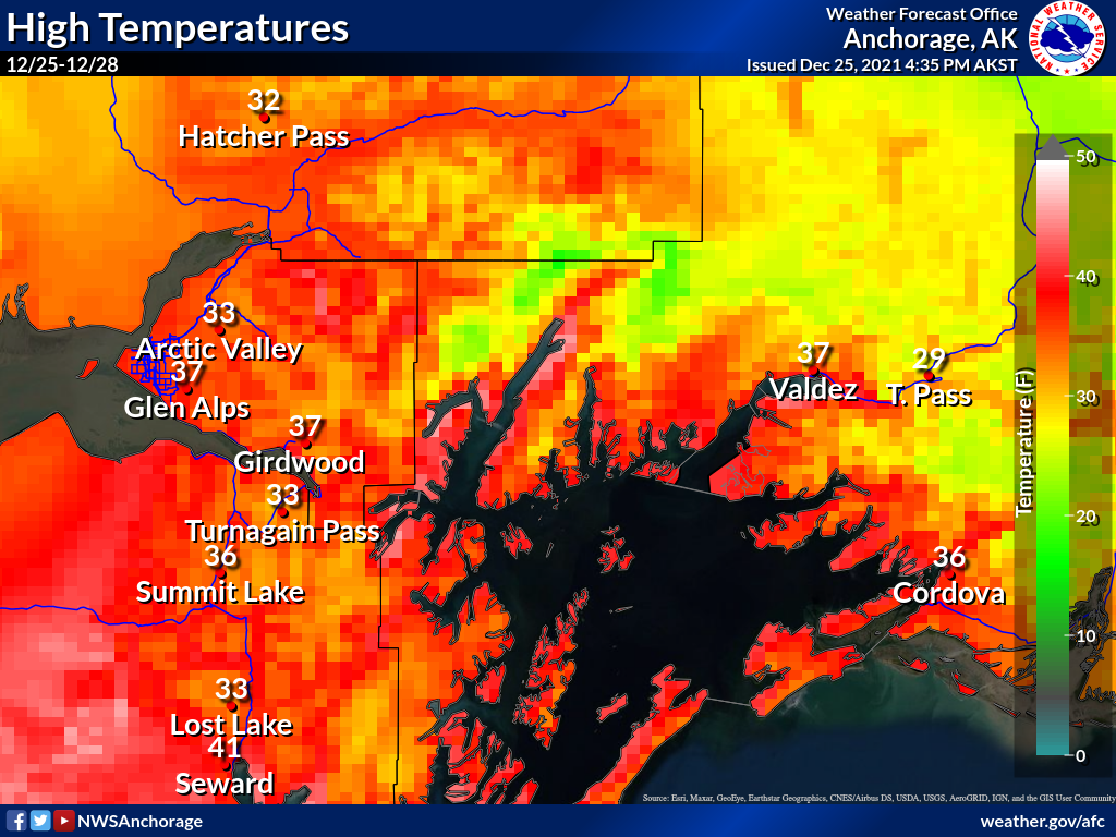
Turnagain Pass Avalanche Forecast RSS

Archives
ARCHIVED FORECAST - All forecasts expire after 24 hours from the posting date/time.
Issued
Sun, December 26th, 2021 - 7:00AM
Expires
Mon, December 27th, 2021 - 7:00AM
Forecaster
Andrew Schauer
Avalanche risk The Bottom Line

Today’s avalanche danger is MODERATE above 1000′. A weak but warm system is expected to bring light rain all the way up to ridgetops, but it does not look like there will be enough moisture to increase avalanche danger. The main concern is the lingering possibility of triggering an avalanche on weak faceted snow buried 2-5′ deep. The only way to manage the problem is by smart terrain choices, which means staying off of big, steep slopes. Be on the lookout for wet loose avalanches on steep slopes that have been sheltered from this week’s winds.

The avalanche danger is LOW below 1000′, where the main concern will be those wet loose avalanches on steep slopes with soft snow on the surface.

Roof Avalanches: Rain and warm temperatures could cause roofs to shed their snow today. Keep an eye on children of pets, and be careful where you park.

SUMMIT LAKE: Stronger southwest winds are expected in the Summit Lake area today. These are expected to drift whatever soft surface snow is left in the area into sensitive wind slabs during the day, which may be easily triggered. Look for and avoid freshly wind-loaded slopes.

Special Announcements
  • Heavier rainfall will lead to Dangerous avalanche conditions at Hatcher Pass, with increasing avalanche danger throughout the day. Be sure to check for updates at hpavalanche.org.
  • The National Weather Service has issued a Winter Weather Advisory through midnight today from Girdwood to Seward. (link here)
  • Colorado avalanche fatality: We are sad to share the news of the fourth U.S. avalanche fatality of the season, in an accident that occurred in Colorado’s Front Range on Christmas Eve. One skier was buried and did not survive. Our condolences go out to the victim’s friends and family. Preliminary details may be found in this CAIC report.
Thanks to our sponsors!
Sun, December 26th, 2021
Alpine
Above 2,500'
Moderate (2)
Avalanche risk
Treeline
1,000'-2,500'
Moderate (2)
Avalanche risk
Below Treeline
Below 1,000'
Low (1)
Avalanche risk
Alpine
Above 2,500'
Avalanche risk
Moderate (2)
Treeline
1,000'-2,500'
Avalanche risk
Moderate (2)
Below Treeline
Below 1,000'
Avalanche risk
Low (1)
Danger Scale:
No Rating (0)
Low (1)
Moderate (2)
Considerable (3)
High (4)
Extreme (5)
Avalanche Problem 1
  • Deep Persistent Slabs
    Deep Persistent Slabs
  • Almost Certain
    Very Likely
    Likely
    Possible
    Unlikely
    Likelihood
  • Historic (D4-5)
    Very Large (D3)
    Large (D2)
    Small (D1)
    Size
Deep Persistent Slabs
Deep Persistent Slab avalanches are the release of a thick cohesive layer of hard snow (a slab), when the bond breaks between the slab and an underlying persistent weak layer deep in the snowpack. The most common persistent weak layers involved in deep, persistent slabs are depth hoar or facets surrounding a deeply buried crust. Deep Persistent Slabs are typically hard to trigger, are very destructive and dangerous due to the large mass of snow involved, and can persist for months once developed. They are often triggered from areas where the snow is shallow and weak, and are particularly difficult to forecast for and manage.

Likelihood of Avalanches
Terms such as "unlikely", "likely", and "certain" are used to define the scale, with the chance of triggering or observing avalanches increasing as we move up the scale. For our purposes, "Unlikely" means that few avalanches could be triggered in avalanche terrain and natural avalanches are not expected. "Certain" means that humans will be able to trigger avalanches on many slopes, and natural avalanches are expected.

Size of Avalanches
Avalanche size is defined by the largest potential avalanche, or expected range of sizes related to the problem in question. Assigned size is a qualitative estimate based on the destructive classification system and requires specialists to estimate the harm avalanches may cause to hypothetical objects located in the avalanche track (AAA 2016, CAA 2014). Under this schema, "Small" avalanches are not large enough to bury humans and are relatively harmless unless they carry people over cliffs or through trees or rocks. Moving up the scale, avalanches become "Large" enough to bury, injure, or kill people. "Very Large" avalanches may bury or destroy vehicles or houses, and "Historic" avalanches are massive events capable of altering the landscape.

Signal Word Size (D scale) Simple Descriptor
Small 1 Unlikely to bury a person
Large 2 Can bury a person
Very Large 3 Can destroy a house
Historic 4 & 5 Can destroy part or all of a village
More info at Avalanche.org

Today’s advisory is going to start with a little good news/bad news. The bad news first- it looks like it is going to rain all the way up to ridgetops today. The good news? Although freezing rain may do some serious damage to riding and skiing conditions, we are not expecting enough water to increase the avalanche danger. The mountains around Girdwood are expected to get 0.25″ water, while Turnagain Pass receives closer to 0.1″.

Our primary avalanche concern is the lingering possibility of triggering a large avalanche on weak, faceted snow buried 2-5′ deep. This layer is showing signs of gaining strength, but still should be approached with caution. The most likely places to trigger an avalanche on a deep persistent weak layer will be areas with a thinner snowpack. We’ve noticed a trend of lower snow depths towards the south end of Turnagain pass down to the Summit Lake area, making these zones the most suspect. While slightly less likely, you may also be able to trigger something big if you find a thin spot on a slope in the northern half of the advisory area too. These monsters are notoriously difficult to predict due in part to their lack of direct feedback prior to avalanching. This means our typical warning signs like shooting cracks, collapsing, and poor stability test results rarely show up when dealing with our current setup, despite potentially dangerous conditions. For now we are still avoiding big, steep slopes just because the consequences of triggering an avalanche on this deep persistent weak layer are too severe. This layer is slowly moving in the right direction, but it still needs time to heal before it should be trusted.

Loose Wet Avalanches: With today’s rain we may see some loose wet avalanches on steep slopes that have remained sheltered from this week’s wind events. These will be most likely at and below treeline. A loose wet avalanche occurring above 1500′ has the potential to trigger a larger avalanche on the deep persistent weak layers mentioned above.

Two graphics from the National Weather Service Anchorage office that we were not thrilled about seeing. Precip totals around 0.1″-0.25″ with warm temperatures mean we are expecting to see some rain today. Courtesy of NWS, 12.25.2021.

Weather
Sun, December 26th, 2021

Yesterday: High temperatures were in the mid 20’s to low 30’s F under mostly cloudy skies. Winds were blowing 5-10 mph out of the south near Girdwood, the east on Seattle Ridge, and the west on Sunburst with no precipitation.

Today: Temperatures have been warming in the early morning and will continue to do so through the day. Weather stations are showing temps in the upper 20’s to low 30’s F as of 6:00 a.m., which are expected to rise into the mid to upper 30’s F. The Girdwood area may see around 0.25-0.3″ rain, while Turnagain Pass and Summit Lakes are expected to see closer to 0.1″. Rain level is expected to make it up to 7000′ during the day. Winds will be 5-10 mph out of the north near Girdwood, and out of the south at Turnagain Pass. Stronger southwesterly winds are expected around 15-20 mph with gusts of 40-50 mph near Summit Lakes.

Tomorrow: Temperatures are expected to drop just below freezing overnight before rising back into the mid 30’s F tomorrow. Cloud cover will break up slightly during the day. Westerly winds will blow 10-20 mph with gusts around 25 mph. No precipitation is expected tomorrow.

PRECIPITATION 24-hour data (6am – 6am)

Temp Avg (F) Snow (in) Water (in) Snow Depth (in)
Center Ridge (1880′) 26 0 0 68
Summit Lake (1400′) 20 0 0 22*
Alyeska Mid (1700′) 25 0 0 41

*Estimate. Snow depth sensor currently not reporting.

RIDGETOP 24-hour data (6am – 6am)

Temp Avg (F) Wind Dir Wind Avg (mph) Wind Gust (mph)
Sunburst (3812′) 27 W 5 20
Seattle Ridge (2400′) 23 E 4 13
Observations
Recent Observations for Turnagain Pass
Date Region Location
05/22/23 Turnagain Avalanche: Tincan
05/12/23 Turnagain Avalanche: Tincan, Sunburst, Magnum, Cornbiscuit
05/07/23 Turnagain Observation: Tincan – Bear Tracks
05/05/23 Turnagain Observation: Seattle Ridge
05/02/23 Turnagain Observation: Cornbiscuit
05/02/23 Turnagain Observation: Seward Hwy Turnagain Pass
04/30/23 Turnagain Observation: Magnum
04/29/23 Turnagain Observation: Tincan
04/28/23 Turnagain Avalanche: Taylor Pass/Pastoral
04/28/23 Turnagain Avalanche: Tincan
Riding Areas
Updated Mon, May 15th, 2023

Status of riding areas across the Chugach NF is managed by the Glacier and Seward Ranger Districts, not avalanche center staff. Riding area information is posted as a public service to our users and updated based on snow depth and snow density to prevent resource damage at trailhead locations. Riding area questions contact: mailroom_r10_chugach@fs.fed.us

Area Status Weather & Riding Conditions
Glacier District
Johnson Pass
Closed
Closed May 15.
Placer River
Closed
Closed May 15.
Skookum Drainage
Closed
Will close to motorized use on April 1, 2023 per the National Forest Plan.
Turnagain Pass
Open
Chugach NF staff will be assessing daily after May 15th. Please keep machines on the snow and avoid brown spots to keep this area open as long as possible.
Twentymile
Closed
Scheduled closure May 1.
Seward District
Carter Lake
Closed
Scheduled closure May 1.
Lost Lake Trail
Closed
Scheduled closure May 1.
Primrose Trail
Closed
Scheduled closure May 1.
Resurrection Pass Trail
Closed
Closed to motorized use for the 2022/23 winter season per Forest Plan. Open next season.
Snug Harbor
Closed
Extended opening until May 15.
South Fork Snow River Corridor
Closed
Scheduled closure May 1.
Summit Lake
Closed
Scheduled closure May 1.

Subscribe to Turnagain Pass
Avalanche Forecast by Email

This is a general backcountry avalanche advisory issued for Turnagain Arm with Turnagain Pass as the core advisory area. This advisory does not apply to highways, railroads or operating ski areas.