Turnagain Pass
|
|
November 13th UPDATE
With another round of snow this week, conditions are shaping up nicely in the CNFAIC advisory area. The most recent storm brought 6-8” of low-density snow to Turnagain Pass, with cold temperatures dropping snow to sea level.
As we ramp up our winter operations, we are working hard to map weak layers in the upper snowpack in our advisory area. Prior to the most recent snowfall, we had found or received reports of widespread surface hoar on Sunburst and Seattle ridge (more details here, here and here), with a spottier distribution on Tincan (details). It is likely this layer can be found in other zones, but our mental map is still somewhat limited this early in the season. In addition to the layer of buried surface hoar, we have also found a layer of near-surface facets buried 1-2 feet deep on some, but not all slopes.
 Surface hoar on top of Seattle Ridge prior to the midweek storm. Photo: Allen Dahl. 11.09.2021
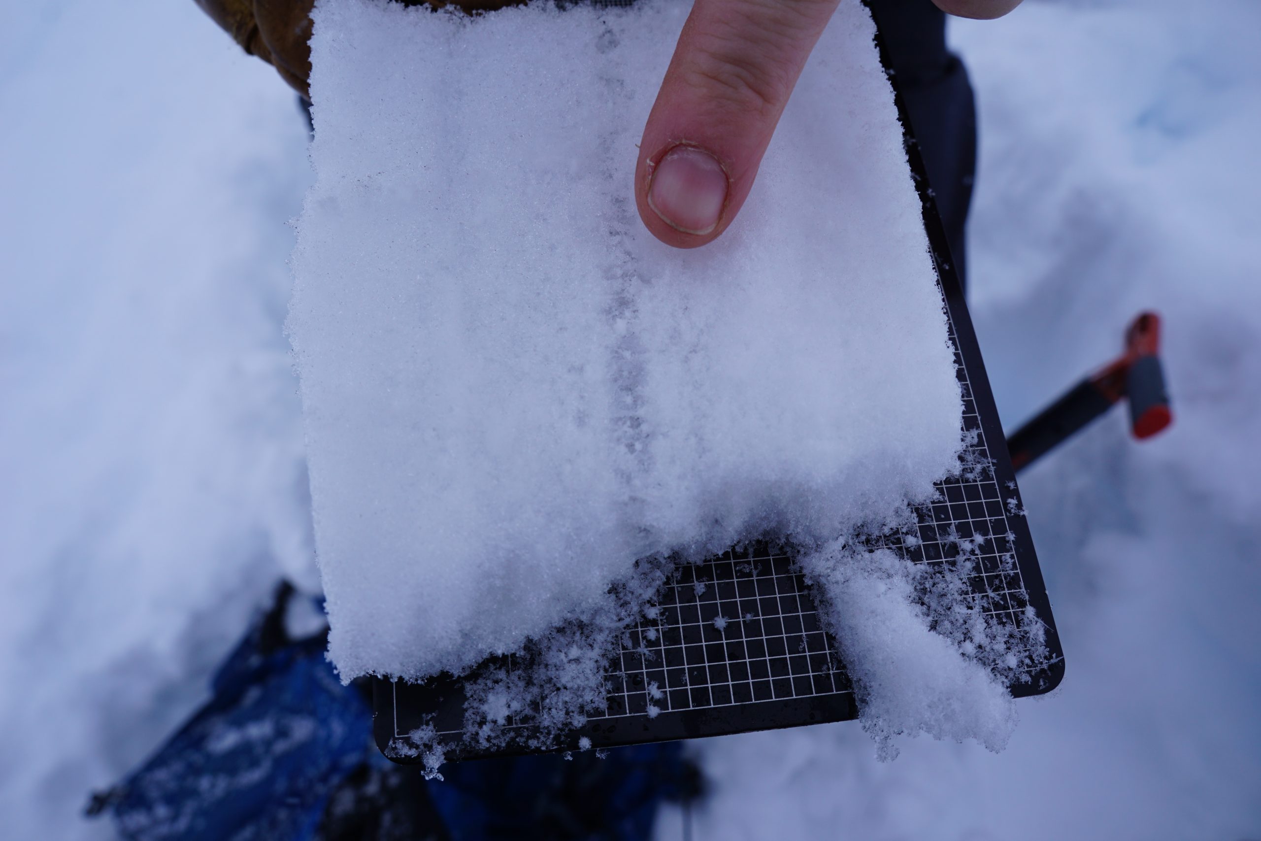 That same layer of surface hoar now buried post- storm, in a slice of snow taken from a snowpit on Seattle Ridge at 2600′. 11.12.2021
As of Friday evening, winds have remained calm, which means the low-density snow from this week’s storm is a very light and fluffy layer that is unlikely to produce an avalanche. However, with two persistent weak layers present in the upper 2 feet of the snowpack and plenty of soft snow on top just waiting to be blown around, we can expect to see increased avalanche activity as soon as the winds pick up and start building wind slabs. John does a great job summarizing the situation in the video below (linked here):
How can you use this info? Pay attention to clear signs the snowpack is giving you. If you notice cracks shooting out from your skis, or the whumpf of a weak layer collapsing, it is likely you would trigger an avalanche in steeper terrain. Avoid steep slopes with a stiff or punchy slab of snow on the surface sitting on top of softer snow. You can also pay attention to the weather forecast. We will expect to see increased likelihood of natural and human-triggered avalanches whenever the winds pick up. Unfortunately the mid-range forecast is not showing very much snow in the next few days, which means the wind will be the main player determining stability for now.
Glide Avalanches
Large glide cracks are present throughout the advisory area. We have seen glide activity on all aspects around 2000-3000’. The timing of glide avalanches is impossible to predict, so the only way to manage the hazard is to avoid spending any time under glide cracks.
Dry Loose Avalanches
As long as the wind doesn’t act up, relatively stable conditions with soft snow on top may make it reasonable to step out into steeper terrain. If you do decide to venture onto steeper slopes, be aware that the 1-2 feet of dry, loose snow at the surface will be ready to move. While this may not be enough snow to bury a person, it can have major consequences if it carries you over rocks or cliffs, or drags you through alders or trees. Extra caution is warranted in the mid and lower elevations where the snowpack is still quite thin.
Snowfall to date @ Turnagain Pass 2,500′ – 3,500′:
Sept 22-24 storm: 16-20″ snow, ~2 – 2.5″ of SWE
Sept 30-Oct1 storm: 12-16″ snow, ~1-1.5″ of SWE
Oct 6-8 storm: 6-8″ snow, 0.7″ SWE
Oct 11 storm: 6″ snow, 0.6″ SWE
Oct 14 storm: 8″ snow, 0.6″ SWE
Oct 17-21 storm: 20-30″ snow, 3.3″ SWE
Oct 22-23 storm: 10″ snow, 1.1″ SWE
Oct 28: 5″ snow, 0.4″ SWE
Oct 29-Nov 2 Halloween Storm Cycle: 7-8′ of snow above 3,000′, 8″ of rain below 2,000′
Nov 4-5: 10″ snow, 1″ SWE
Nov 10-11: 7” snow, 0.5” SWE
ANNOUNCEMENTS:
-
Our non-profit arm, Friends of the Chugach Avalanche Center, is looking for a volunteer to work on the website. Contact chugachavyfriends@gmail.com for more information!
-
The Avalanche Center will begin issuing intermittent snow, weather and avalanche updates as conditions warrant through mid November.
-
Daily avalanche forecasts are planned to begin around Thanksgiving week.
- We will be hosting several ‘Forecaster Chats’ this December into January. Stay tuned for dates and topics.
- The best way to keep tabs on current events/information for the early season is on our Facebook page and Instagram.
 Looking south down Turnagain Pass along Seattle Ridge. We’re off to a great start, but we’re going to need some more snow to get the machines up here! 11.12.2021
