Turnagain Pass
|
|
November 6th UPDATE
What a week! The historic Halloween storm that rolled in late on Oct 29th is finally loosening its grip. Highest precipitation rates were on Oct 30 and 31 with records being set in Portage Valley and Girdwood. Portage saw almost 28″ of rain from Oct 29 – Nov 4 and Girdwood 19″, seriously?! That’s a good 20 feet above 3,500′ in those areas. Girdwood saw several roads washed out and one very large landslide near Cooper Landing closed the Sterling Highway for nearly 36 hours. For that same time period, Turnagain Pass saw 8.5″ of rain below 2,000′, equaling around 8-9 feet of snow above 3,500′. Dang. A widespread avalanche cycle ensued, of course. With such cloudy conditions, the evidence mostly lies at the bottom of slide paths in snow-free zones where countless white piles of debris now sit. There are a few photos below, but also check out our observations page.
 From the NWS: “It’s official! #Portage Glacier Visitor Center is now the furthest north station in the US to report consecutive days of 8″ or more of rain. The 10.34″ that fell on 10/30 was Alaska’s first 10″ in a single day rainfall since Cannery Creek in 2012. #AKwx“
 Precipitation totals from Oct 29 to Nov 4 for Girdwood and Portage.
With so much stormy weather, high avalanche danger and low visibility, very few folks have ventured into the hills. However, a brief break on Wednesday, Nov 3rd allowed for a peak. We’ll be headed out this weekend for a better look when skies hopefully open up.
 Merrick Mordal had to dig about 9 feet down to reach the ground in Hippy Bowl on Tincan (around 3,500′). 11.3.21 Andres Mordal.
AVALANCHE DANGER
We are headed into the ‘post big storm’ phase this weekend and possibly high pressure and clearer skies this coming week. What that means is observing and assessing as you go. The classic RED FLAGS will be our friends and we should listen to them. With the brunt of the storm almost a week ago now and very warm temperatures throughout, there is a good chance the snowpack could be stabilizing well. But, if we see things otherwise, all bets are off. Really paying attention to signs of recent avalanches, cracking in the snow around you or ‘whumpfing’ in the snow under your feet, is critical. Has the wind been blowing recently and formed a wind slab near the ridgeline? Are there glide cracks poking through showing us where not to stop to limit time under? Chat with your partners, see what they are seeing and feeling too.
Red Flag reminder:
- Recent avalanches
- Cracks that shoot out in the snow or collapsing (whumpfing) in the snowpack
- Changes in weather (snow/rain/wind/rapid warming)
*Good travel practices are also critical. That means only exposing one person at a time, choosing up-routes carefully, having an escape route planned, and watching our partners closely.
GLIDE AVALANCHES
Glide avalanches are still widespread in the region and forecast to keep releasing this week. So far these slides are continuing to release in the 2,000-3,000′ elevation band and running to valley bottom in places. Glide cracks are easy to see if we look for them and it’s always good practice to limit any exposure under them. They are completely unpredictable and can release at anytime.
If you get out, please consider sending us a note and a few photos on our ‘submit’ an observations page!
 Cooper Landing – the access road to Cooper Lake Dam has been covered by debris from an avalanche above. The road is closed to pubic. Photo taken 11.2.21 by Joel Norris.
 Sunburst Ridge – glide avalanches are still releasing. Photo taken 11.3.21 by Graham Predeger.
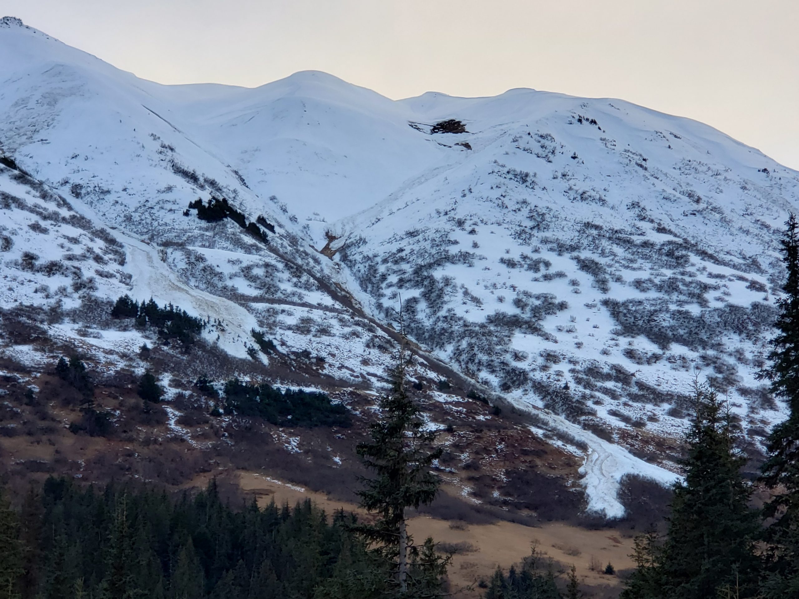 Seattle Ridge south end – avalanche debris easily seen at the bottom of slide paths. Seen across from the Bertha Creek campground at Turnagain Pass. Photo taken 11.3.21 by Joel Curtis.
CURRENT SNOWPACK:
Snowpack depths in the Turnagain Pass area are still slim to none in the parking lots, but by the time you get to 2,500′ (generally top of the treeline) it’s looking like 6-8′ of settled snow. Above 3,500′ it is looking more like 8-12′ of snow depending on location. We will be assessing this week as to any weak layers in the pack, aside from the glide avalanche problem.

Snowfall to date @ Turnagain Pass 2,500′ – 3,500′:
Sept 22-24 storm: 16-20″ snow, ~2 – 2.5″ of SWE
Sept 30-Oct1 storm: 12-16″ snow, ~1-1.5″ of SWE
Oct 6-8 storm: 6-8″ snow, 0.7″ SWE
Oct 11 storm: 6″ snow, 0.6″ SWE
Oct 14 storm: 8″ snow, 0.6″ SWE
Oct 17-21 storm: 20-30″ snow, 3.3″ SWE
Oct 22-23 storm: 10″ snow, 1.1″ SWE
Oct 28: 5″ snow, 0.4″ SWE
Oct 29-Nov 2 Halloween Storm Cycle: 7-8′ of snow above 3,000′, 8″ of rain below 2,000′
Nov 4-5: 10″ snow, 1″ SWE
Snow depth at the Turnagain Pass SNOTEL (1880′): 41″
Settled snow depth estimated at 3,000′: 8-12′!
As always, keep tabs on current weather on our famous weather page!
ANNOUNCEMENTS:
- The Avalanche Center will begin issuing intermittent snow, weather and avalanche updates as conditions warrant through mid November.
- Daily avalanche forecasts are planned to begin around Thanksgiving week.
- We will be hosting several ‘Forecaster Chats’ this December into January. Stay tuned for dates and topics.
- The best way to keep tabs on current events/information for the early season is on our Facebook page and Instagram.
EVENTS:
- November 12th, 12pm – 4:15pm virtual on Zoom – get your tickets now for the 9th Annual Southcentral Alaska Avalanche Workshop!!

