Turnagain Pass RSS

Archives
ARCHIVED - Forecasts expire after 24 hours.
Issued
Sat, April 10th, 2021 - 7:00AM
Expires
Sun, April 11th, 2021 - 7:00AM
Forecaster
Wendy Wagner
Avalanche risk The Bottom Line

The avalanche danger is MODERATE above 1,000′. Human triggered wind slab avalanches will be possible. Wind slabs formed by the strong northwest winds over the past two days are expected to be hard, anywhere from inches to several feet thick and may allow a person well onto them before releasing. They also may step down and break in old weak layers in the top 3 feet of the snowpack, creating a larger avalanche.

The danger is LOW below 1,000′ where hard surface crusts exist.

Special Announcements

CNFAIC End Of Season Operations:  Daily avalanche forecasts typically transition to a 4 day/week cycle (Sat, Sun, Tues, Thur) beginning this coming week as our forecast season and funding winds down. Due to the impressively late spring and active weather coming in, we will continue to forecast on the off days if avalanche danger is rising.

Hatcher Pass:  Be sure to check out HPAC’s Saturday morning forecast at hpavalanche.org. The road to Hatcher Pass remains closed at MP10. For updates see AK 511 and follow AKDOT&PF on social media.

Sat, April 10th, 2021
Alpine
Above 2,500'
2 - Moderate
Avalanche risk
Treeline
1,000'-2,500'
2 - Moderate
Avalanche risk
Below Treeline
Below 1,000'
1 - Low
Avalanche risk
0 - No Rating
1 - Low
2 - Moderate
3 - Considerable
4 - High
5 - Extreme
Avalanche risk Avalanche risk Avalanche risk Avalanche risk Avalanche risk
Travel Advice Generally safe avalanche conditions. Watch for unstable snow on isolated terrain features. Heightened avalanche conditions on specific terrain features. Evaluate snow and terrain carefully; identify features of concern. Dangerous avalanche conditions. Careful snowpack evaluation, cautious route-finding, and conservative decision-making essential. Very dangerous avalanche conditions. Travel in avalanche terrain not recommended. Extraordinarily dangerous avalanche conditions. Avoid all avalanche terrain.
Likelihood of Avalanches Natural and human-triggered avalanches unlikely. Natural avalanches unlikely; human-triggered avalanches possible. Natural avalanches possible; human-triggered avalanches likely. Natural avalanches likely; human-triggered avalanches very likely. Natural and human-triggered avalanches certain.
Avalanche Size and Distribution Small avalanches in isolated areas or extreme terrain. Small avalanches in specific areas; or large avalanches in isolated areas. Small avalanches in many areas; or large avalanches in specific areas; or very large avalanches in isolated areas. Large avalanches in many areas; or very large avalanches in specific areas. Very large avalanches in many areas.
Recent Avalanches

Yesterday afternoon, during the tail end of a 1.5 day intense northwest wind event, we were able to get a look around as to the damage these winds caused. The majority of the natural wind slab avalanches seen were south of Turnagain Pass in Summit Lake and down toward Seward. There were a few natural wind slabs along Turnagain Arm and one larger slab on Raggedtop near Girdwood. We did not see any new avalanches from the road in Turnagain Pass itself despite a significant amount of wind effect.

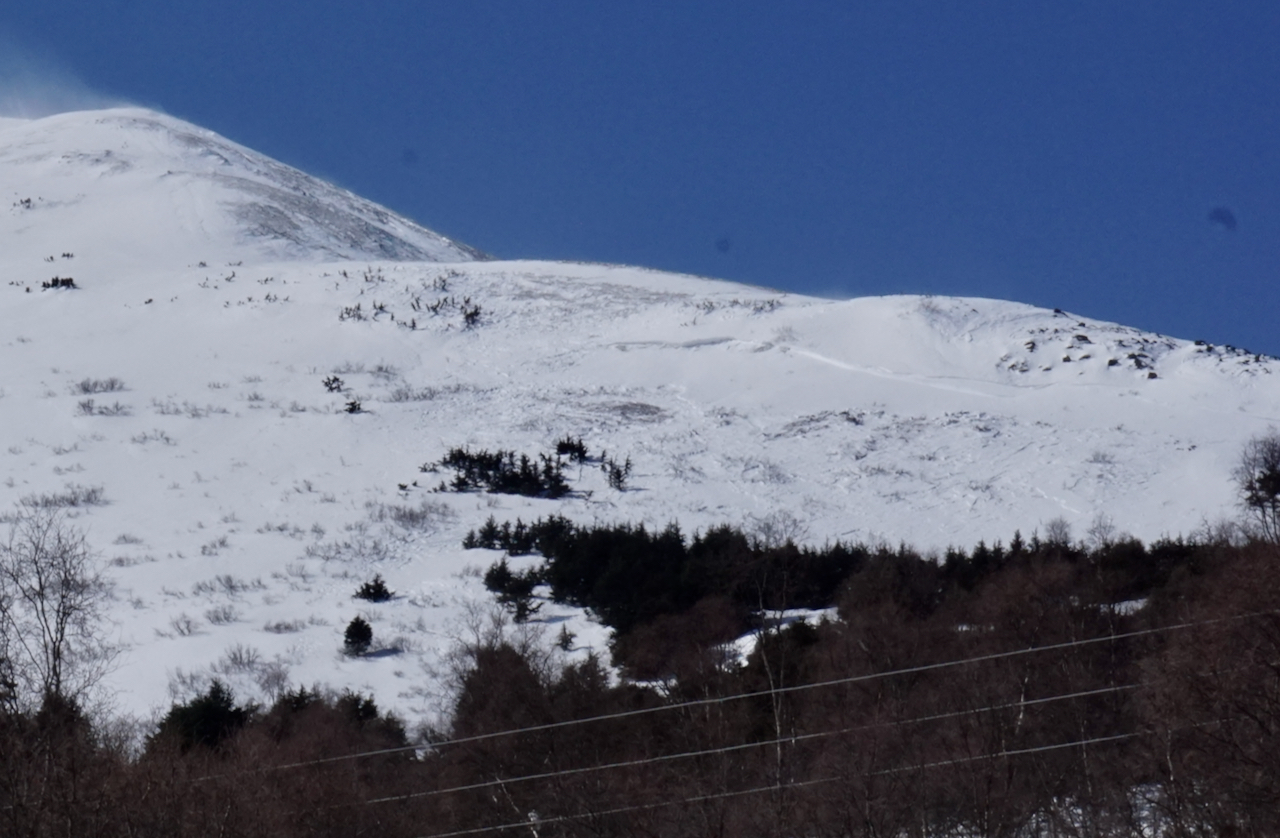
Natural wind slab avalanche releasing sometime overnight on Thursday (4.8) or early Friday morning (4.9) in the Summit Lake are seen from the Seward Highway. This slope is the northern most avalanche path on Summit Peak. Slab looks to have stepped down into weak layers near the ground. 4.9.21.


Natural avalanche on Raggedtop in the upper Girdwood Valley/Crow Creek area. Released sometime during the NW winds on 4.8 or 4.9. This is the 4th time a portion of this face has slid over the past few weeks. Photo taken 4.9.21.


A bone-fide dust storm (a haboob if we were in the Sahara) tore down Turnagain Arm Thursday and Friday. 4.9.21.


A blanket of dust now covers the slopes on Kern and Blueberry mountains along Turnagain Arm.


Avalanche Problem 1
  • Wind Slabs
    Wind Slabs
  • Certain
    Very Likely
    Likely
    Possible
    Unlikely
    Likelihood
  • Historic (D4-5)
    Very Large (D3)
    Large (D2)
    Small (D1)
    Size
Wind Slabs
Wind Slab avalanches are the release of a cohesive layer of snow (a slab) formed by the wind. Wind typically transports snow from the upwind sides of terrain features and deposits snow on the downwind side. Wind slabs are often smooth and rounded and sometimes sound hollow, and can range from soft to hard. Wind slabs that form over a persistent weak layer (surface hoar, depth hoar, or near-surface facets) may be termed Persistent Slabs or may develop into Persistent Slabs.

Likelihood of Avalanches
Terms such as "unlikely", "likely", and "certain" are used to define the scale, with the chance of triggering or observing avalanches increasing as we move up the scale. For our purposes, "Unlikely" means that few avalanches could be triggered in avalanche terrain and natural avalanches are not expected. "Certain" means that humans will be able to trigger avalanches on many slopes, and natural avalanches are expected.

Size of Avalanches
Avalanche size is defined by the largest potential avalanche, or expected range of sizes related to the problem in question. Assigned size is a qualitative estimate based on the destructive classification system and requires specialists to estimate the harm avalanches may cause to hypothetical objects located in the avalanche track (AAA 2016, CAA 2014). Under this schema, "Small" avalanches are not large enough to bury humans and are relatively harmless unless they carry people over cliffs or through trees or rocks. Moving up the scale, avalanches become "Large" enough to bury, injure, or kill people. "Very Large" avalanches may bury or destroy vehicles or houses, and "Historic" avalanches are massive events capable of altering the landscape.

Signal Word Size (D scale) Simple Descriptor
Small 1 Unlikely to bury a person
Large 2 Can bury a person
Very Large 3 Can destroy a house
Historic 4 & 5 Can destroy part or all of a village
More info at Avalanche.org

With a quiet, but cold, weather day on tap before the next system moves in tomorrow, lingering wind slabs formed by the strong northwest winds will be the main concern. These slabs should be quite hard and on a variety of aspects due to the intense pummeling of the winds in a variety of directions. Although much of the snow surface saw scouring, exposing old sun crusts on southerly aspects and forming anti-tracks wherever old tracks existed, there are sure to be some newly wind loaded terrain features to watch out for. Additionally, wind slabs could be overlying old weak layers, especially to the south of Turnagain Pass around Summit Lake where a much thinner and weaker snowpack exists (more in Problem #2).

Keep an eye out for areas where the winds deposited snow in large drifts or slabs. These often appear as smooth rounded surfaces where stiffer snow sits over softer snow. Slabs could be found lower on the slopes and even in the trees. Watch for cracks that shoot out from you or collapsing (whumpfing) in the snowpack. These are clues you’ve found a slab.

Even though we may see some sunshine and warming daytime temperatures, surface crusts are not likely to warm or soft much with the cold temperatures and light breeze.

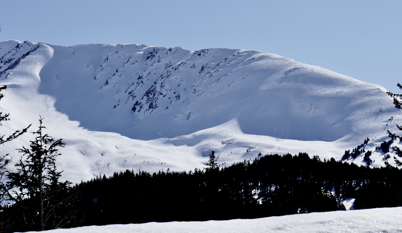
The north side of Tincan seen yesterday. Much of the soft surface snow appears to have been wind effected. Note the wind ripples and anti-tracks along the CRF ridge on the right side of the picture. 4.9.21.

Avalanche Problem 2
  • Persistent Slabs
    Persistent Slabs
  • Certain
    Very Likely
    Likely
    Possible
    Unlikely
    Likelihood
  • Historic (D4-5)
    Very Large (D3)
    Large (D2)
    Small (D1)
    Size
Persistent Slabs
Persistent Slab avalanches are the release of a cohesive layer of snow (a slab) in the middle to upper snowpack, when the bond to an underlying persistent weak layer breaks. Persistent layers include: surface hoar, depth hoar, near-surface facets, or faceted snow. Persistent weak layers can continue to produce avalanches for days, weeks or even months, making them especially dangerous and tricky. As additional snow and wind events build a thicker slab on top of the persistent weak layer, this avalanche problem may develop into a Deep Persistent Slab.

Likelihood of Avalanches
Terms such as "unlikely", "likely", and "certain" are used to define the scale, with the chance of triggering or observing avalanches increasing as we move up the scale. For our purposes, "Unlikely" means that few avalanches could be triggered in avalanche terrain and natural avalanches are not expected. "Certain" means that humans will be able to trigger avalanches on many slopes, and natural avalanches are expected.

Size of Avalanches
Avalanche size is defined by the largest potential avalanche, or expected range of sizes related to the problem in question. Assigned size is a qualitative estimate based on the destructive classification system and requires specialists to estimate the harm avalanches may cause to hypothetical objects located in the avalanche track (AAA 2016, CAA 2014). Under this schema, "Small" avalanches are not large enough to bury humans and are relatively harmless unless they carry people over cliffs or through trees or rocks. Moving up the scale, avalanches become "Large" enough to bury, injure, or kill people. "Very Large" avalanches may bury or destroy vehicles or houses, and "Historic" avalanches are massive events capable of altering the landscape.

Signal Word Size (D scale) Simple Descriptor
Small 1 Unlikely to bury a person
Large 2 Can bury a person
Very Large 3 Can destroy a house
Historic 4 & 5 Can destroy part or all of a village
More info at Avalanche.org

The natural avalanches seen in both Raggedtop near Girdwood and Summit Lake mentioned above, both point to wind slabs overloading older weak layers. These are the facets and buried surface hoar in the top 3 feet of the pack that we haven’t stopped talking about. It’s clear the wind slab in Summit Lake broke into older weak layers creating a larger avalanche. The Summit Lake area has a thinner and weaker pack making this more concerning here. Also, judging by the photo from Raggedtop, old weak layers could have played a role here too. Although we have not seen this at Turnagain Pass recently, it’s good to keep on our radar anywhere we go. Slopes on the northern half of the compass are most concerning as they do not have sun crusts to help tie the pack together.

Knowing these layers are there, listening/feeling for whumpfing and watching for any other signs of instability are good things to keep in mind. As always, use good travel protocol, and consider the consequences if an avalanche does occur.

Weather
Sat, April 10th, 2021

Yesterday:  Clear skies with the last portion of a strong northwest wind event that died off around midnight. Ridgetop averages were 15-30mph with gusts twice that. Temperatures were downright cold, in the minus single digits at the high elevations and single digits in the lower elevations that warmed up to near 20F midday.

Today:  Some cloud cover is forecast to move overhead today as we enter a pattern shift to an active south and easterly flow that should bring in warmer temperatures and some precipitation beginning Sunday. For today, we can expect light west winds turning easterly (5-10mph) along the ridgetops and slowly rising temperatures (mid 20’sF at sea level and ~10F along the ridgelines).

Tomorrow:  Cloudy skies, strong easterly winds and light snow showers are expected to begin Sunday morning. Snowfall looks to make it to sea level with around 2-4″ of accumulation through the day. Snow is expected to pick up Sunday night into Monday with a rising snow/rain line to ~500′ and the chance for 4-6″ of snow by Monday evening. Stay tuned as active weather and rising temperatures are slated for the whole of next week!

PRECIPITATION 24-hour data (6am – 6am)

Temp Avg (F) Snow (in) Water (in) Snow Depth (in)
Center Ridge (1880′) 9 0 0 107
Summit Lake (1400′) 6 0 0 48
Alyeska Mid (1700′) 10 0 0 117

RIDGETOP 24-hour data (6am – 6am)

Temp Avg (F) Wind Dir Wind Avg (mph) Wind Gust (mph)
Sunburst (3812′) -2 W 11 32
Seattle Ridge (2400′) 4 NW 12 29
Observations
Recent Observations for Turnagain Pass
Date Region Location
04/23/24 Turnagain Observation: Turnagain Sunny Side
04/21/24 Turnagain Observation: Bertha Creek
04/20/24 Turnagain Avalanche: Spokane Creek
04/16/24 Turnagain Observation: Cornbiscuit
04/15/24 Turnagain Observation: Taylor Pass
04/15/24 Turnagain Observation: Seward Highway – Tern Lake to Portage
04/14/24 Turnagain Observation: Sunburst
04/14/24 Turnagain Observation: Turnagain Pass Snomo
04/13/24 Turnagain Observation: Spokane Creek
04/11/24 Turnagain Observation: Tincan
Riding Areas

The riding areas page has moved. Please click here & update your bookmarks.


Subscribe to Turnagain Pass
Avalanche Forecast by Email

This is a general backcountry avalanche advisory issued for Turnagain Arm with Turnagain Pass as the core advisory area. This advisory does not apply to highways, railroads or operating ski areas.