Turnagain Pass RSS

Archives
ARCHIVED - Forecasts expire after 24 hours.
Issued
Sun, April 2nd, 2023 - 7:00AM
Expires
Mon, April 3rd, 2023 - 7:00AM
Forecaster
Andrew Schauer
Avalanche risk The Bottom Line

The avalanche danger remains CONSIDERABLE above 1000′. We have seen multiple massive avalanches triggered by people over the past week, and dangerous conditions continue today. These avalanches are thousands of feet wide and 3-6′ deep or deeper, and have been triggered remotely from low-angle terrain connected to steeper slopes. The only way to truly steer clear of this avalanche problem is by avoiding traveling on or below steep slopes.

The danger is MODERATE below 1000′. Avalanches triggered at upper elevations have the potential to run far into low-elevation runout zones. It is also likely we will see loose snow avalanches with more sun and mild temps on the way today.

Sun, April 2nd, 2023
Alpine
Above 2,500'
3 - Considerable
Avalanche risk
Treeline
1,000'-2,500'
3 - Considerable
Avalanche risk
Below Treeline
Below 1,000'
2 - Moderate
Avalanche risk
0 - No Rating
1 - Low
2 - Moderate
3 - Considerable
4 - High
5 - Extreme
Avalanche risk Avalanche risk Avalanche risk Avalanche risk Avalanche risk
Travel Advice Generally safe avalanche conditions. Watch for unstable snow on isolated terrain features. Heightened avalanche conditions on specific terrain features. Evaluate snow and terrain carefully; identify features of concern. Dangerous avalanche conditions. Careful snowpack evaluation, cautious route-finding, and conservative decision-making essential. Very dangerous avalanche conditions. Travel in avalanche terrain not recommended. Extraordinarily dangerous avalanche conditions. Avoid all avalanche terrain.
Likelihood of Avalanches Natural and human-triggered avalanches unlikely. Natural avalanches unlikely; human-triggered avalanches possible. Natural avalanches possible; human-triggered avalanches likely. Natural avalanches likely; human-triggered avalanches very likely. Natural and human-triggered avalanches certain.
Avalanche Size and Distribution Small avalanches in isolated areas or extreme terrain. Small avalanches in specific areas; or large avalanches in isolated areas. Small avalanches in many areas; or large avalanches in specific areas; or very large avalanches in isolated areas. Large avalanches in many areas; or very large avalanches in specific areas. Very large avalanches in many areas.
Recent Avalanches

A snowmachiner triggered a large wind slab avalanche just outside our advisory area near Whittier yesterday. He was able to ride off the slab and was not caught or carried. The avalanche was up to 3’ deep, 250’ wide, and ran 600’ vertical. More details here.

Photo of the snowmachine-triggered avalanche near Whittier yesterday. Photo: Warren Gage 04.01.2023

Avalanche Problem 1
  • Deep Persistent Slabs
    Deep Persistent Slabs
  • Aspect/Elevation
  • Certain
    Very Likely
    Likely
    Possible
    Unlikely
    Likelihood
  • Historic (D4-5)
    Very Large (D3)
    Large (D2)
    Small (D1)
    Size
Deep Persistent Slabs
Deep Persistent Slab avalanches are the release of a thick cohesive layer of hard snow (a slab), when the bond breaks between the slab and an underlying persistent weak layer deep in the snowpack. The most common persistent weak layers involved in deep, persistent slabs are depth hoar or facets surrounding a deeply buried crust. Deep Persistent Slabs are typically hard to trigger, are very destructive and dangerous due to the large mass of snow involved, and can persist for months once developed. They are often triggered from areas where the snow is shallow and weak, and are particularly difficult to forecast for and manage.

Aspect/Elevation of the Avalanche Problem
Specialists develop a graphic representation of the potential distribution of a particular avalanche problem across the topography. This aspect/elevation rose is used to indicate where the particular avalanche problem is thought to exist on all elevation aspects. Areas where the avalanche problem is thought to exist are colored grey, and it is less likely to be encountered in areas colored white.

Likelihood of Avalanches
Terms such as "unlikely", "likely", and "certain" are used to define the scale, with the chance of triggering or observing avalanches increasing as we move up the scale. For our purposes, "Unlikely" means that few avalanches could be triggered in avalanche terrain and natural avalanches are not expected. "Certain" means that humans will be able to trigger avalanches on many slopes, and natural avalanches are expected.

Size of Avalanches
Avalanche size is defined by the largest potential avalanche, or expected range of sizes related to the problem in question. Assigned size is a qualitative estimate based on the destructive classification system and requires specialists to estimate the harm avalanches may cause to hypothetical objects located in the avalanche track (AAA 2016, CAA 2014). Under this schema, "Small" avalanches are not large enough to bury humans and are relatively harmless unless they carry people over cliffs or through trees or rocks. Moving up the scale, avalanches become "Large" enough to bury, injure, or kill people. "Very Large" avalanches may bury or destroy vehicles or houses, and "Historic" avalanches are massive events capable of altering the landscape.

Signal Word Size (D scale) Simple Descriptor
Small 1 Unlikely to bury a person
Large 2 Can bury a person
Very Large 3 Can destroy a house
Historic 4 & 5 Can destroy part or all of a village
More info at Avalanche.org

Our main concern is still the potential for triggering a really big avalanche on the weak layer of facets that was buried two weeks ago. Since last Saturday we’ve seen almost 20 huge avalanches triggered on this layer, and the problem remains today. These avalanches have been 3-6′ deep or deeper, and many of them were triggered remotely from low-angle terrain connected to steeper slopes. This is a remarkable amount of activity for a deep slab problem, and it is nothing to mess around with. As we get further out from our last major loading event this layer is becoming more stubborn and avalanches are slowly becoming less likely, but we are still on edge about it.

These deep persistent slab avalanches rarely give any warning signs prior to avalanching, and our normal stability tests don’t tell us anything about how reactive the snowpack is. All we have to rely on is the fact that we continue to see big avalanches failing on this layer, and we have seen a very poor setup in every snowpit we’ve dug over the past week. This includes snowpits on Tincan, Sunburst, Magnum, Cornbiscuit,  and Lipps. The avalanches we saw on the back side of Seattle Ridge and in the Skookum drainage are all the snowpack info we need to tell us that poor structure is consistent across our advisory area.  For now the only way to manage the problem is to avoid traveling on or below steep terrain, and wait for that weak layer to gain some strength.

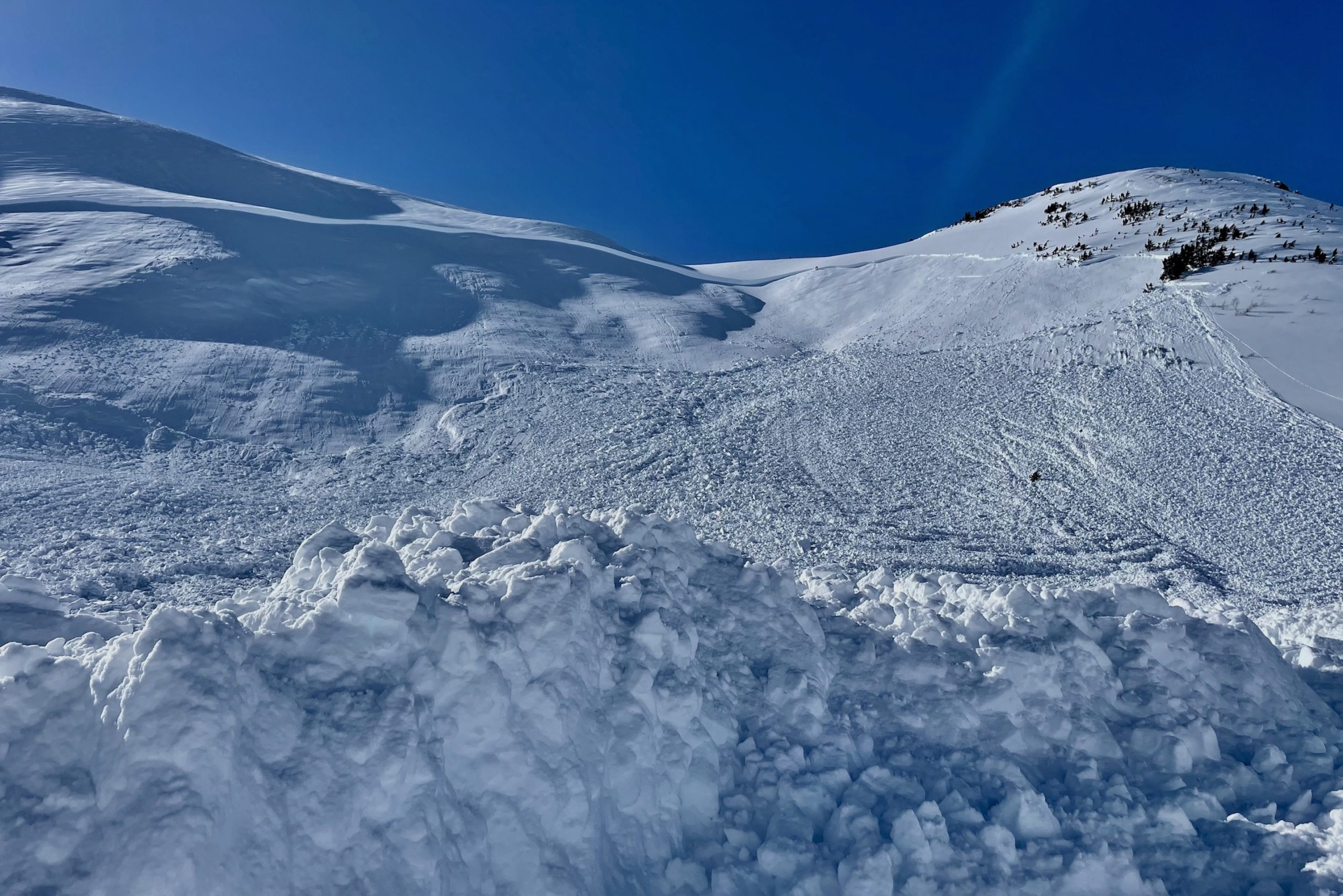
This is the setup that is giving us so many problems. The combination of a 3′ thick hard slab on top of a reactive weak layer is not a good one. Photo taken Thursday on Cornbiscuit, but this is the same structure throughout the advisory area.

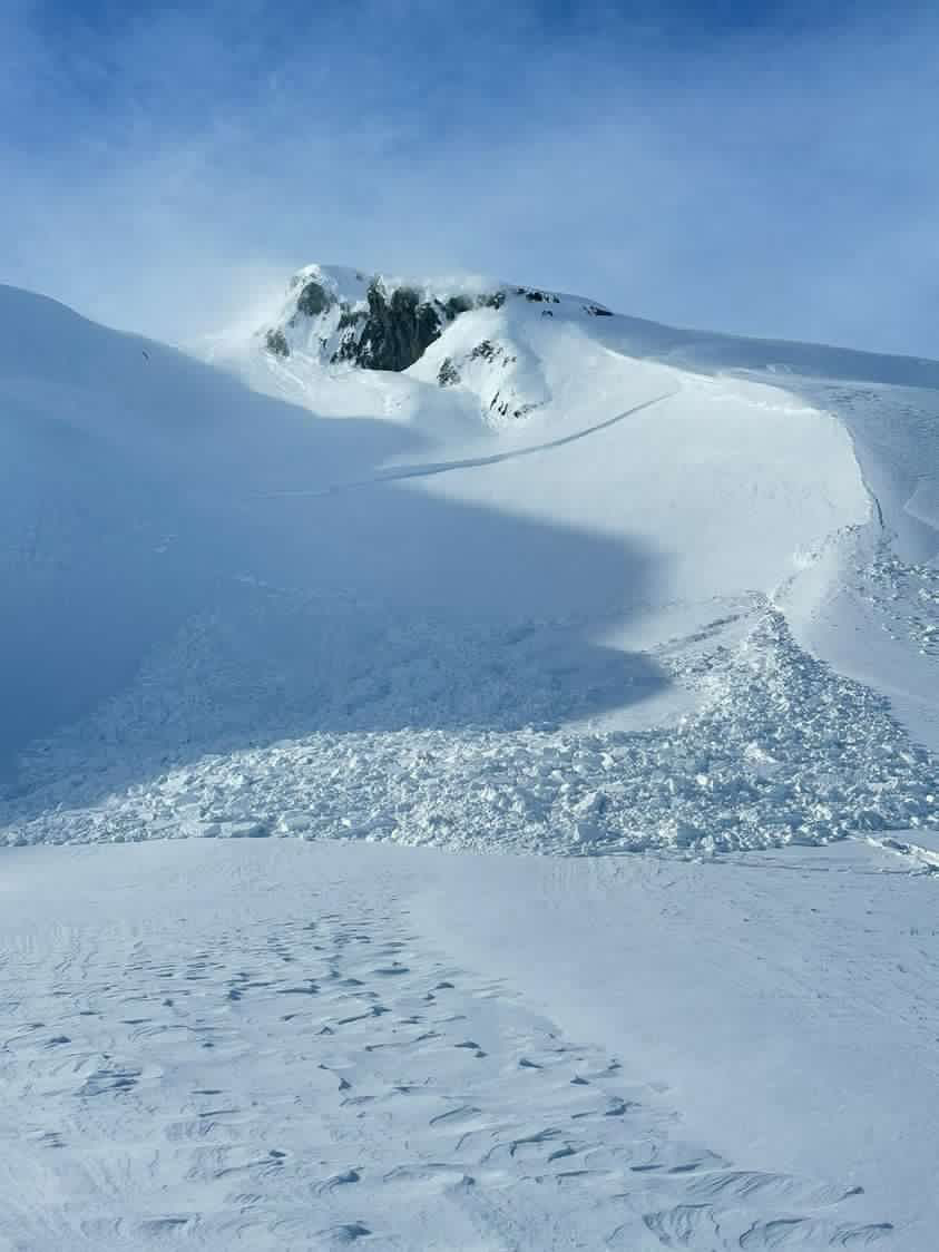
This avalanche occurred last Saturday, but it is the kind of thing we are still concerned about today.


Avalanche Problem 2
  • Wind Slabs
    Wind Slabs
  • Aspect/Elevation
  • Certain
    Very Likely
    Likely
    Possible
    Unlikely
    Likelihood
  • Historic (D4-5)
    Very Large (D3)
    Large (D2)
    Small (D1)
    Size
Wind Slabs
Wind Slab avalanches are the release of a cohesive layer of snow (a slab) formed by the wind. Wind typically transports snow from the upwind sides of terrain features and deposits snow on the downwind side. Wind slabs are often smooth and rounded and sometimes sound hollow, and can range from soft to hard. Wind slabs that form over a persistent weak layer (surface hoar, depth hoar, or near-surface facets) may be termed Persistent Slabs or may develop into Persistent Slabs.

Aspect/Elevation of the Avalanche Problem
Specialists develop a graphic representation of the potential distribution of a particular avalanche problem across the topography. This aspect/elevation rose is used to indicate where the particular avalanche problem is thought to exist on all elevation aspects. Areas where the avalanche problem is thought to exist are colored grey, and it is less likely to be encountered in areas colored white.

Likelihood of Avalanches
Terms such as "unlikely", "likely", and "certain" are used to define the scale, with the chance of triggering or observing avalanches increasing as we move up the scale. For our purposes, "Unlikely" means that few avalanches could be triggered in avalanche terrain and natural avalanches are not expected. "Certain" means that humans will be able to trigger avalanches on many slopes, and natural avalanches are expected.

Size of Avalanches
Avalanche size is defined by the largest potential avalanche, or expected range of sizes related to the problem in question. Assigned size is a qualitative estimate based on the destructive classification system and requires specialists to estimate the harm avalanches may cause to hypothetical objects located in the avalanche track (AAA 2016, CAA 2014). Under this schema, "Small" avalanches are not large enough to bury humans and are relatively harmless unless they carry people over cliffs or through trees or rocks. Moving up the scale, avalanches become "Large" enough to bury, injure, or kill people. "Very Large" avalanches may bury or destroy vehicles or houses, and "Historic" avalanches are massive events capable of altering the landscape.

Signal Word Size (D scale) Simple Descriptor
Small 1 Unlikely to bury a person
Large 2 Can bury a person
Very Large 3 Can destroy a house
Historic 4 & 5 Can destroy part or all of a village
More info at Avalanche.org

With another day of northwest outflow winds on the way, we expect to see reactive wind slabs continue to form today. These will be most likely just below ridgelines, in steep gullies, or on convex rolls. Yesterday a snowmachiner triggered a wind slab avalanche big enough to bury a person just outside of our advisory area near Whittier, and we expect to find with similar conditions throughout our advisory area. While these avalanches are much smaller than the deep slabs we are concerned about (see Problem 1), they are still big enough to be paying attention to. Be on the lookout for snow blowing off ridgetops as you travel as an indicator that senisive wind slabs are forming. Fresh wind slabs may give you warning signs like shooting cracks, and the surface will feel stiffer than the snow that has stayed protected from winds. As mentioned above, the weak setup we’re dealing with already has us sticking to low-angle terrain, so this wind slab problem is really just one more thing to watch out for.

Loose Wet Avalanches: The sun will once again be a factor today, with mostly clear skies and mild temperatures on the way. We will likely see the snow surface heating up enough on southeast to southwest slopes to see some loose wet avalanches this afternoon. There is a chance that one of these loose snow avalanches failing near the surface could pull out a bigger slab as it moves downhill. Pay attention to changing conditions through the day, and be aware of increasing danger as you start to see rollerballs on solar aspects or feel those surface crusts breaking down in the afternoon.

You can click here to view the video below if it doesn’t load in your browser.

Weather
Sun, April 2nd, 2023

Yesterday: Skies were mostly sunny with a few clouds and winds out of the northwest at 5-10 mph, gusting 10-20 mph.  Temperatures got up into the mid to upper 30’s F at lower elevations, and in the mid to upper 20’s at higher elevations. We did not see any precipitation yesterday.

Today: It is looking like another fine day of weather is on the way, with mostly sunny skies and temperatures getting up into the upper 20’s to mid 30’s F. Winds will be out of the northwest at 10-20 mph with gusts of 15-25 mph, blowing strongest at the usual gaps like along the Turnagain Arm towards Portage and Whittier, and down in Seward. Low temperatures tonight will drop back down to the mid teens F. No precipitation is expected today.

Tomorrow: Clouds are expected to build through the day as a low pressure system moves into the Gulf. Winds will switch back to the southeast at 10-20 mph, and we might see some light flurries later in the day. High temperatures should be in the mid 20’s to low 30’s F, with lows in the upper teens to low 20’s F.

PRECIPITATION 24-hour data (6am – 6am)

Temp Avg (F) Snow (in) Water (in) Snow Depth (in)
Center Ridge (1880′) 29 0 0 94
Summit Lake (1400′) 25 0 0 46
Alyeska Mid (1700′) N/A N/A N/A N/A
Bear Valley – Portage (132′) 32 0 0

RIDGETOP 24-hour data (6am – 6am)

Temp Avg (F) Wind Dir Wind Avg (mph) Wind Gust (mph)
Sunburst (3812′) 16 WNW 7 24
Seattle Ridge (2400′) 25 NW 7 21
Observations
Recent Observations for Turnagain Pass
Date Region Location
04/23/24 Turnagain Observation: Turnagain Sunny Side
04/21/24 Turnagain Observation: Bertha Creek
04/20/24 Turnagain Avalanche: Spokane Creek
04/16/24 Turnagain Observation: Cornbiscuit
04/15/24 Turnagain Observation: Taylor Pass
04/15/24 Turnagain Observation: Seward Highway – Tern Lake to Portage
04/14/24 Turnagain Observation: Sunburst
04/14/24 Turnagain Observation: Turnagain Pass Snomo
04/13/24 Turnagain Observation: Spokane Creek
04/11/24 Turnagain Observation: Tincan
Riding Areas

The riding areas page has moved. Please click here & update your bookmarks.


Subscribe to Turnagain Pass
Avalanche Forecast by Email

This is a general backcountry avalanche advisory issued for Turnagain Arm with Turnagain Pass as the core advisory area. This advisory does not apply to highways, railroads or operating ski areas.