Turnagain Pass RSS

Archives
ARCHIVED - Forecasts expire after 24 hours.
Issued
Mon, April 3rd, 2023 - 7:00AM
Expires
Tue, April 4th, 2023 - 7:00AM
Forecaster
Andrew Schauer
Avalanche risk The Bottom Line

The avalanche danger is CONSIDERABLE above 2500′ as strong easterly winds will make it likely a person will be able to trigger a fresh wind slab avalanche up to a foot deep. There is also still a small possibility of triggering a very large avalanche failing on weak snow buried 3-6′ deep or deeper. The danger is MODERATE below 2500′, where we will be less likely to find fresh wind slabs big enough to bury a person, but we are still concerned with the potential for triggering a very large avalanche that deeper weak layer. Careful terrain selection is still the name of the game, limiting exposure to steep terrain and runout zones.

Mon, April 3rd, 2023
Alpine
Above 2,500'
3 - Considerable
Avalanche risk
Treeline
1,000'-2,500'
2 - Moderate
Avalanche risk
Below Treeline
Below 1,000'
2 - Moderate
Avalanche risk
0 - No Rating
1 - Low
2 - Moderate
3 - Considerable
4 - High
5 - Extreme
Avalanche risk Avalanche risk Avalanche risk Avalanche risk Avalanche risk
Travel Advice Generally safe avalanche conditions. Watch for unstable snow on isolated terrain features. Heightened avalanche conditions on specific terrain features. Evaluate snow and terrain carefully; identify features of concern. Dangerous avalanche conditions. Careful snowpack evaluation, cautious route-finding, and conservative decision-making essential. Very dangerous avalanche conditions. Travel in avalanche terrain not recommended. Extraordinarily dangerous avalanche conditions. Avoid all avalanche terrain.
Likelihood of Avalanches Natural and human-triggered avalanches unlikely. Natural avalanches unlikely; human-triggered avalanches possible. Natural avalanches possible; human-triggered avalanches likely. Natural avalanches likely; human-triggered avalanches very likely. Natural and human-triggered avalanches certain.
Avalanche Size and Distribution Small avalanches in isolated areas or extreme terrain. Small avalanches in specific areas; or large avalanches in isolated areas. Small avalanches in many areas; or large avalanches in specific areas; or very large avalanches in isolated areas. Large avalanches in many areas; or very large avalanches in specific areas. Very large avalanches in many areas.
Recent Avalanches

The last avalanche within our advisory area was a large remote-triggered avalanche north of Girdwood last Tuesday. This was the latest of 18 very large human-triggered avalanches over the past 9 days, all of which we suspect were failing on the layer of facets that was buried on 3/14.

Avalanche Problem 1
  • Wind Slabs
    Wind Slabs
  • Aspect/Elevation
  • Certain
    Very Likely
    Likely
    Possible
    Unlikely
    Likelihood
  • Historic (D4-5)
    Very Large (D3)
    Large (D2)
    Small (D1)
    Size
Wind Slabs
Wind Slab avalanches are the release of a cohesive layer of snow (a slab) formed by the wind. Wind typically transports snow from the upwind sides of terrain features and deposits snow on the downwind side. Wind slabs are often smooth and rounded and sometimes sound hollow, and can range from soft to hard. Wind slabs that form over a persistent weak layer (surface hoar, depth hoar, or near-surface facets) may be termed Persistent Slabs or may develop into Persistent Slabs.

Aspect/Elevation of the Avalanche Problem
Specialists develop a graphic representation of the potential distribution of a particular avalanche problem across the topography. This aspect/elevation rose is used to indicate where the particular avalanche problem is thought to exist on all elevation aspects. Areas where the avalanche problem is thought to exist are colored grey, and it is less likely to be encountered in areas colored white.

Likelihood of Avalanches
Terms such as "unlikely", "likely", and "certain" are used to define the scale, with the chance of triggering or observing avalanches increasing as we move up the scale. For our purposes, "Unlikely" means that few avalanches could be triggered in avalanche terrain and natural avalanches are not expected. "Certain" means that humans will be able to trigger avalanches on many slopes, and natural avalanches are expected.

Size of Avalanches
Avalanche size is defined by the largest potential avalanche, or expected range of sizes related to the problem in question. Assigned size is a qualitative estimate based on the destructive classification system and requires specialists to estimate the harm avalanches may cause to hypothetical objects located in the avalanche track (AAA 2016, CAA 2014). Under this schema, "Small" avalanches are not large enough to bury humans and are relatively harmless unless they carry people over cliffs or through trees or rocks. Moving up the scale, avalanches become "Large" enough to bury, injure, or kill people. "Very Large" avalanches may bury or destroy vehicles or houses, and "Historic" avalanches are massive events capable of altering the landscape.

Signal Word Size (D scale) Simple Descriptor
Small 1 Unlikely to bury a person
Large 2 Can bury a person
Very Large 3 Can destroy a house
Historic 4 & 5 Can destroy part or all of a village
More info at Avalanche.org

There are two main problems to watch out for today, and it is hard to say which one should be at the top of the list. The most likely avalanches will be failing up to a foot deep or so where strong easterly winds are going to build fresh wind slabs today. Less likely, but much more scary, is the potential for triggering a massive avalanche failing deeper in the snowpack. More on that in Problem 2.

Winds are expected to be light this morning but increasing through the day, with sustained speeds of up to 30 mph and gusts to 40 mph by this afternoon. These strong winds will form a fresh round of wind slabs that will be especially reactive this afternoon. These are most likely to be found just below ridgelines, in cross loaded gullies, and on convex rollovers. There are a few clues you can use to look for unstable snow. From a distance, be on the lookout for snow blowing off ridgelines as a key indicator that fresh slabs are forming at higher elevations. As you travel, you can spot unstable conditions by watching for cracks shooting out from your skis or snowmachine, or by using small test slopes to see how the snow surface is reacting.

Keep in mind, these fresh wind slabs will be adding load to a snowpack that has produced multiple very large avalanches failing on an older weak layer buried 3-6′ deep. We are still dealing with a scary snowpack setup, and that is giving us cause to stick to lower angle and low consequence terrain for now.

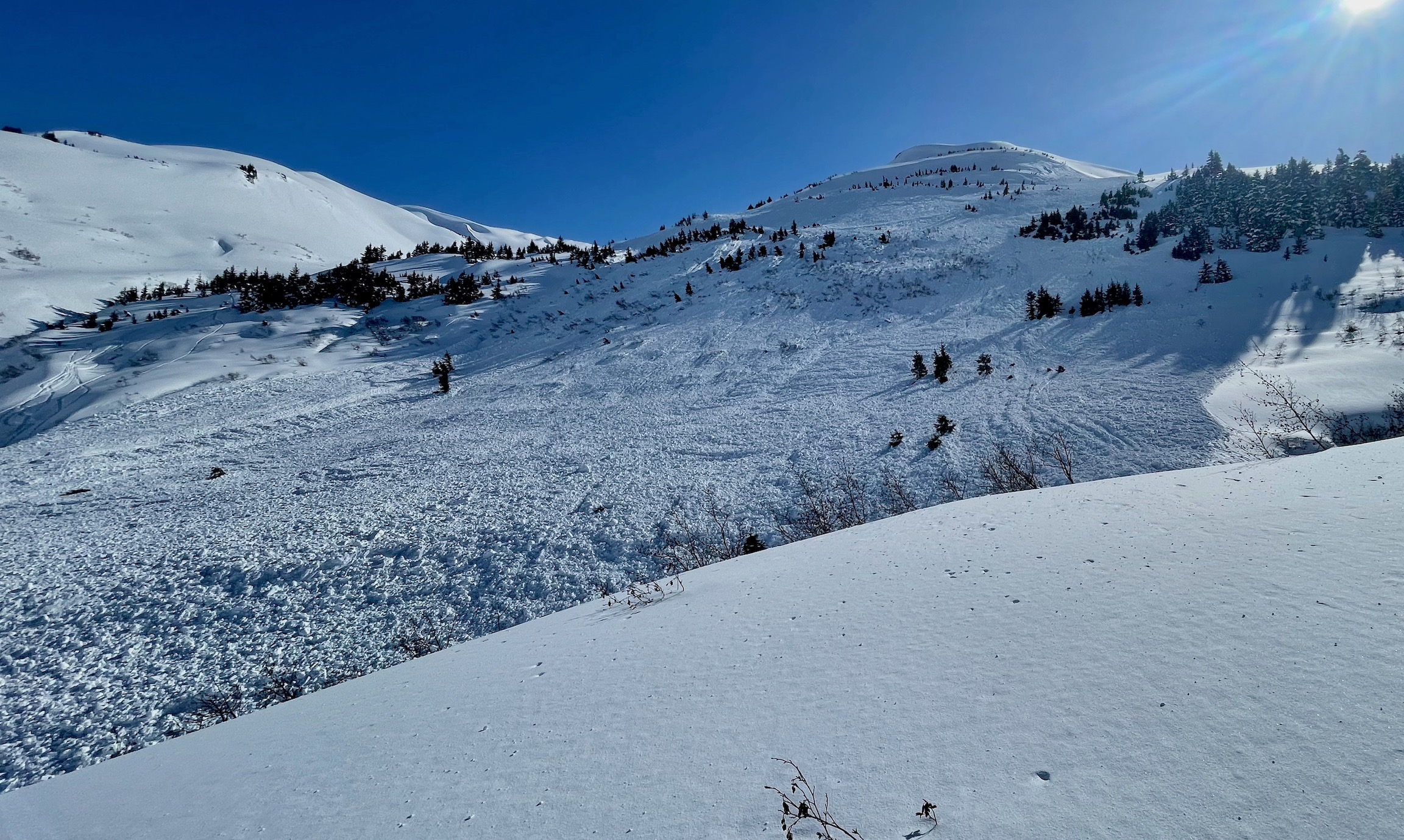
It is likely a person will be able to trigger an avalanche similar to this snowmachine-triggered avalanche as winds ramp up through the day. Photo: Warren Gage, 04.01.2023

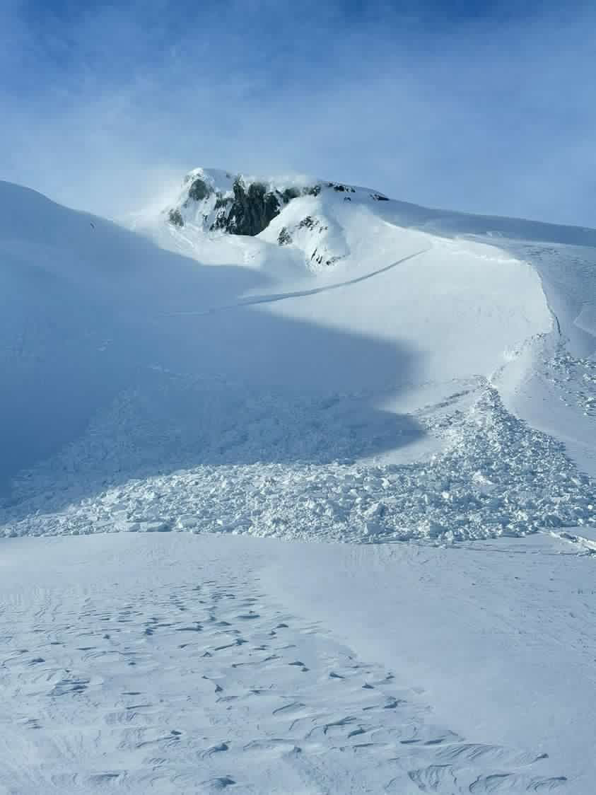
Watch for snow blowing off ridgelines as a sign of increasing avalanche danger in the upper elevations. 04.01.2023


Avalanche Problem 2
  • Deep Persistent Slabs
    Deep Persistent Slabs
  • Aspect/Elevation
  • Certain
    Very Likely
    Likely
    Possible
    Unlikely
    Likelihood
  • Historic (D4-5)
    Very Large (D3)
    Large (D2)
    Small (D1)
    Size
Deep Persistent Slabs
Deep Persistent Slab avalanches are the release of a thick cohesive layer of hard snow (a slab), when the bond breaks between the slab and an underlying persistent weak layer deep in the snowpack. The most common persistent weak layers involved in deep, persistent slabs are depth hoar or facets surrounding a deeply buried crust. Deep Persistent Slabs are typically hard to trigger, are very destructive and dangerous due to the large mass of snow involved, and can persist for months once developed. They are often triggered from areas where the snow is shallow and weak, and are particularly difficult to forecast for and manage.

Aspect/Elevation of the Avalanche Problem
Specialists develop a graphic representation of the potential distribution of a particular avalanche problem across the topography. This aspect/elevation rose is used to indicate where the particular avalanche problem is thought to exist on all elevation aspects. Areas where the avalanche problem is thought to exist are colored grey, and it is less likely to be encountered in areas colored white.

Likelihood of Avalanches
Terms such as "unlikely", "likely", and "certain" are used to define the scale, with the chance of triggering or observing avalanches increasing as we move up the scale. For our purposes, "Unlikely" means that few avalanches could be triggered in avalanche terrain and natural avalanches are not expected. "Certain" means that humans will be able to trigger avalanches on many slopes, and natural avalanches are expected.

Size of Avalanches
Avalanche size is defined by the largest potential avalanche, or expected range of sizes related to the problem in question. Assigned size is a qualitative estimate based on the destructive classification system and requires specialists to estimate the harm avalanches may cause to hypothetical objects located in the avalanche track (AAA 2016, CAA 2014). Under this schema, "Small" avalanches are not large enough to bury humans and are relatively harmless unless they carry people over cliffs or through trees or rocks. Moving up the scale, avalanches become "Large" enough to bury, injure, or kill people. "Very Large" avalanches may bury or destroy vehicles or houses, and "Historic" avalanches are massive events capable of altering the landscape.

Signal Word Size (D scale) Simple Descriptor
Small 1 Unlikely to bury a person
Large 2 Can bury a person
Very Large 3 Can destroy a house
Historic 4 & 5 Can destroy part or all of a village
More info at Avalanche.org

As we move further away from our last major loading event, the snowpack has had more time to adjust and the weak layer that was responsible for all of the huge avalanches over the past 9 days has become more stubborn. It has now been 6 days since the last known avalanche on this weak layer. Based on what we’ve been seeing in snowpits over the past week (details in our observations from Girdwood, Sunburst, and Magnum), we know that weak layer of concern is still there lurking well below the surface. For now, that scary setup has us avoiding traveling on or below steep slopes. The likelihood of triggering an avalanche is decreasing, but the consequences are just too high to mess with it. We have seen multiple avalanches triggered remotely from low-angle terrain connected to steeper slopes, and these monsters are running far into lower elevation runout zones. The layer is slowly gaining strength, but we are not ready to trust it yet.

This avalanche is the kind of thing that we are still concerned with. The avalanche was triggered over a week ago and it is becoming less likely, but the setup is still there and it has our attention. 03.25.2023

Weather
Mon, April 3rd, 2023

Yesterday: Skies were mostly sunny with moderate outflow winds blowing 5-15 mph with gusts of 15-25 mph. High temperatures were in the upper teens F at ridgetops and close to 40 F at low elevations, with lows in the mid teens to mid 20’s F. We did not see any precipitation.

Today: We are expecting a pattern change today as a low pressure system in the Gulf shifts winds back to the east with clouds building through the day. Light winds this morning will be increasing all day, with sustained speeds this afternoon of 15-30 mph and gusts up to 40 mph. High temperatures will be in the low 20’s F at upper elevations and in the low 30’s F at low elevations. Chances for precipitation increase in the afternoon, but it is unlikely we will see any accumulation.

Tomorrow: Easterly winds will continue tomorrow, with average speeds of 15-25 mph and gusts of 20-30 mph. Skies will be mostly cloudy, and we will see some light precipitation that may bring a trace to an inch of new snow. High temperatures will be in the mid 20’s to low 30’s F, with lows in the mid to upper 20’s F.

PRECIPITATION 24-hour data (6am – 6am)

Temp Avg (F) Snow (in) Water (in) Snow Depth (in)
Center Ridge (1880′) 28 0 0 93
Summit Lake (1400′) 23 0 0 46
Alyeska Mid (1700′) 29 0 0 85
Bear Valley – Portage (132′) 28 0 0

RIDGETOP 24-hour data (6am – 6am)

Temp Avg (F) Wind Dir Wind Avg (mph) Wind Gust (mph)
Sunburst (3812′) 16 NW 6 24
Seattle Ridge (2400′) 22 NW 6 19
Observations
Recent Observations for Turnagain Pass
Date Region Location
03/28/24 Turnagain Observation: Sunburst
03/27/24 Turnagain Observation: Tincan Trees
03/26/24 Turnagain Observation: Cornbiscuit
03/25/24 Turnagain Observation: Tincan
03/22/24 Turnagain Avalanche: Magnum Northwest Aspect
03/21/24 Turnagain Observation: Sunburst
03/21/24 Turnagain Observation: Tincan Proper North Aspect
03/20/24 Turnagain Avalanche: Seattle Creek Drainage
03/19/24 Turnagain Observation: Tincan CFR
03/18/24 Turnagain Avalanche: Tincan – Eddies – Seattle Ridge
Riding Areas

The riding areas page has moved. Please click here & update your bookmarks.


Subscribe to Turnagain Pass
Avalanche Forecast by Email

This is a general backcountry avalanche advisory issued for Turnagain Arm with Turnagain Pass as the core advisory area. This advisory does not apply to highways, railroads or operating ski areas.