Turnagain Pass RSS

Archives
ARCHIVED - Forecasts expire after 24 hours.
Issued
Sat, April 1st, 2023 - 7:00AM
Expires
Sun, April 2nd, 2023 - 7:00AM
Forecaster
John Sykes
Avalanche risk The Bottom Line

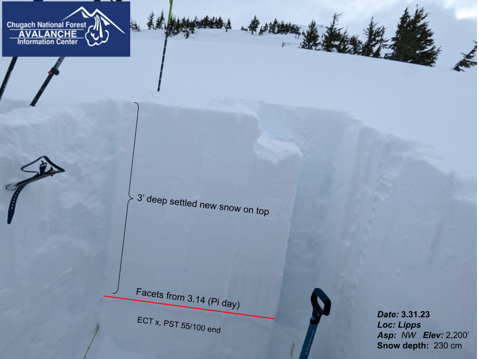
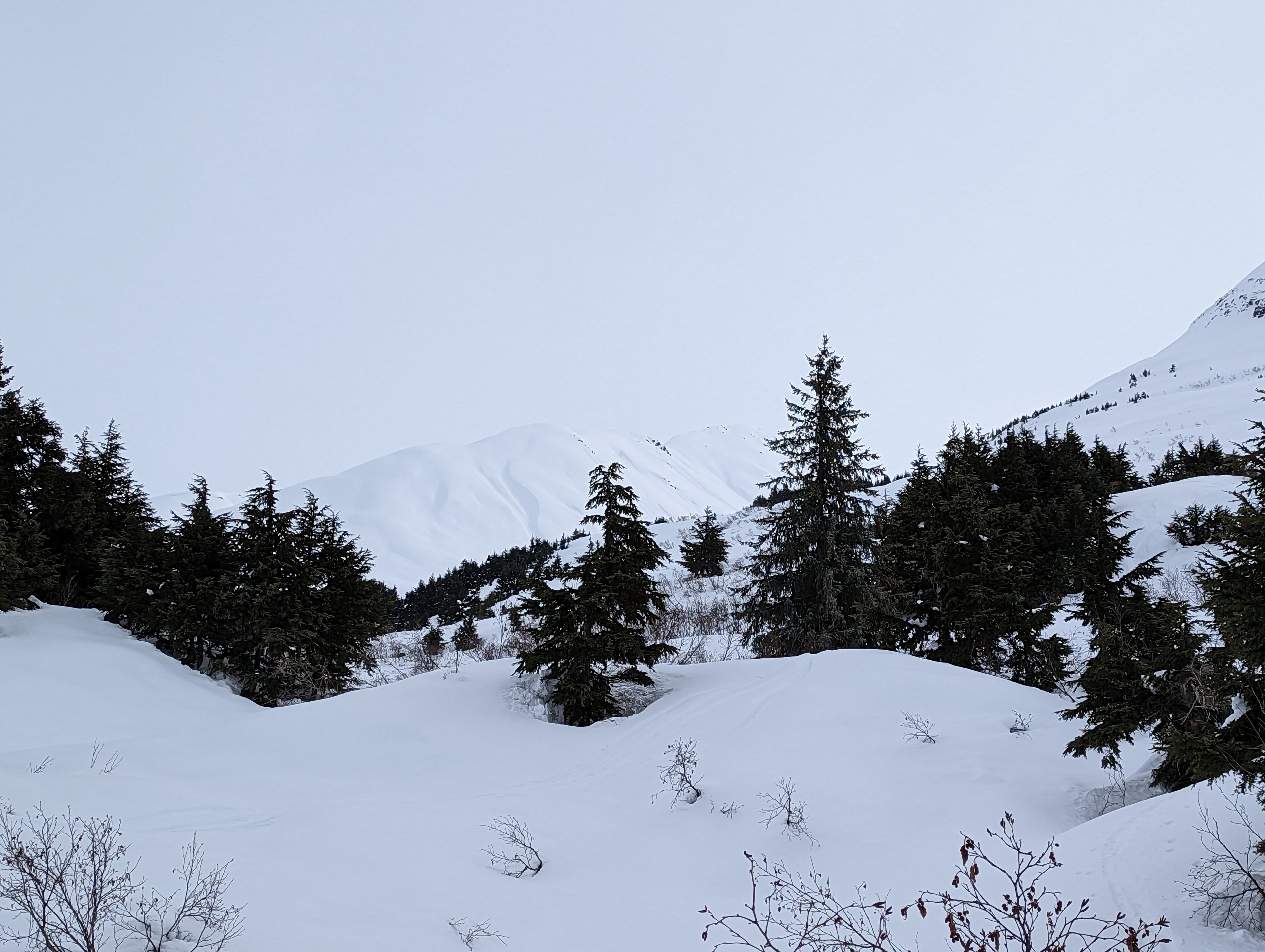
The avalanche danger remains CONSIDERABLE above 1000′. Very large human triggered avalanches 3-6′ deep on a buried weak layer are still possible. Over the past 10 days there have been several close calls with avalanches on this layer and due to the consequences of triggering one of these avalanches we are keeping the avalanche danger elevated. In addition we are expecting 10-20 mph winds today that will build fresh wind slabs up to a foot deep at upper elevations. We continue to recommend sticking to low angle terrain and avoiding runout areas of overhead avalanche paths.

Below 1000′ the avalanche danger is MODERATE. Wet loose avalanches on solar aspects, glide cracks, and areas in the runout of larger avalanche paths are the main dangers below treeline.

Special Announcements

SKOOKUM VALLEY will close to motorized use TODAY, April 1st, due to the National Forest Plan. The boundary extends East of the Railroad tracks from Luebner Lake (South) to private property boundary (North). The rest of the Placer River Valley remains open.

Sat, April 1st, 2023
Alpine
Above 2,500'
3 - Considerable
Avalanche risk
Treeline
1,000'-2,500'
3 - Considerable
Avalanche risk
Below Treeline
Below 1,000'
2 - Moderate
Avalanche risk
0 - No Rating
1 - Low
2 - Moderate
3 - Considerable
4 - High
5 - Extreme
Avalanche risk Avalanche risk Avalanche risk Avalanche risk Avalanche risk
Travel Advice Generally safe avalanche conditions. Watch for unstable snow on isolated terrain features. Heightened avalanche conditions on specific terrain features. Evaluate snow and terrain carefully; identify features of concern. Dangerous avalanche conditions. Careful snowpack evaluation, cautious route-finding, and conservative decision-making essential. Very dangerous avalanche conditions. Travel in avalanche terrain not recommended. Extraordinarily dangerous avalanche conditions. Avoid all avalanche terrain.
Likelihood of Avalanches Natural and human-triggered avalanches unlikely. Natural avalanches unlikely; human-triggered avalanches possible. Natural avalanches possible; human-triggered avalanches likely. Natural avalanches likely; human-triggered avalanches very likely. Natural and human-triggered avalanches certain.
Avalanche Size and Distribution Small avalanches in isolated areas or extreme terrain. Small avalanches in specific areas; or large avalanches in isolated areas. Small avalanches in many areas; or large avalanches in specific areas; or very large avalanches in isolated areas. Large avalanches in many areas; or very large avalanches in specific areas. Very large avalanches in many areas.
Recent Avalanches

There were no new avalanches reported yesterday. The last human-triggered avalanche was a large remote-triggered avalanche north of Girdwood on Tuesday. That was just the latest in a string of very large human-triggered avalanches in the area in the past 10 days. Check out observations from MagnumSeattle RidgeSunburstPalmer Creek (Hope), and Winner Creek to get a sense of the recent activity.

Avalanche Problem 1
  • Deep Persistent Slabs
    Deep Persistent Slabs
  • Aspect/Elevation
  • Certain
    Very Likely
    Likely
    Possible
    Unlikely
    Likelihood
  • Historic (D4-5)
    Very Large (D3)
    Large (D2)
    Small (D1)
    Size
Deep Persistent Slabs
Deep Persistent Slab avalanches are the release of a thick cohesive layer of hard snow (a slab), when the bond breaks between the slab and an underlying persistent weak layer deep in the snowpack. The most common persistent weak layers involved in deep, persistent slabs are depth hoar or facets surrounding a deeply buried crust. Deep Persistent Slabs are typically hard to trigger, are very destructive and dangerous due to the large mass of snow involved, and can persist for months once developed. They are often triggered from areas where the snow is shallow and weak, and are particularly difficult to forecast for and manage.

Aspect/Elevation of the Avalanche Problem
Specialists develop a graphic representation of the potential distribution of a particular avalanche problem across the topography. This aspect/elevation rose is used to indicate where the particular avalanche problem is thought to exist on all elevation aspects. Areas where the avalanche problem is thought to exist are colored grey, and it is less likely to be encountered in areas colored white.

Likelihood of Avalanches
Terms such as "unlikely", "likely", and "certain" are used to define the scale, with the chance of triggering or observing avalanches increasing as we move up the scale. For our purposes, "Unlikely" means that few avalanches could be triggered in avalanche terrain and natural avalanches are not expected. "Certain" means that humans will be able to trigger avalanches on many slopes, and natural avalanches are expected.

Size of Avalanches
Avalanche size is defined by the largest potential avalanche, or expected range of sizes related to the problem in question. Assigned size is a qualitative estimate based on the destructive classification system and requires specialists to estimate the harm avalanches may cause to hypothetical objects located in the avalanche track (AAA 2016, CAA 2014). Under this schema, "Small" avalanches are not large enough to bury humans and are relatively harmless unless they carry people over cliffs or through trees or rocks. Moving up the scale, avalanches become "Large" enough to bury, injure, or kill people. "Very Large" avalanches may bury or destroy vehicles or houses, and "Historic" avalanches are massive events capable of altering the landscape.

Signal Word Size (D scale) Simple Descriptor
Small 1 Unlikely to bury a person
Large 2 Can bury a person
Very Large 3 Can destroy a house
Historic 4 & 5 Can destroy part or all of a village
More info at Avalanche.org

All our weak layers have healed and the mountains are good to go, APRIL FOOLS! We are still dealing with a deeply buried weak layer 3-6′ deep that has caused almost 20 large to very large avalanches over the past 10 days. These include a few historic size avalanches and several that were triggered remotely, meaning the party that triggered them was on lower angle terrain and the avalanche released in a steeper area connected to where the group was travelling. In a few of these recent avalanches the weak layer failed for half a mile or more across the slope and multiple large avalanches were triggered simultaneously. These are uncommon and dangerous conditions!

While the weak layer is likely gaining some strength over time and becoming more stubborn to trigger, due to the consequences of being involved with one of these avalanches we are still recommending avoiding slopes over 30 degrees and being very aware of the runout zones of large avalanche paths. With the sun expected to come out today and warm up the snowpack human triggered deep slab avalanches could be more likely on solar aspects this afternoon. There is also a chance that we could see natural deep slab avalanches if the sun is really cooking. Patience is the key to staying safe while we have this dangerous snowpack setup!

Poor snowpack structure near the top of the treeline elevation band on the NW shoulder of Lipps. 3.31.23

Avalanche Problem 2
  • Wind Slabs
    Wind Slabs
  • Aspect/Elevation
  • Certain
    Very Likely
    Likely
    Possible
    Unlikely
    Likelihood
  • Historic (D4-5)
    Very Large (D3)
    Large (D2)
    Small (D1)
    Size
Wind Slabs
Wind Slab avalanches are the release of a cohesive layer of snow (a slab) formed by the wind. Wind typically transports snow from the upwind sides of terrain features and deposits snow on the downwind side. Wind slabs are often smooth and rounded and sometimes sound hollow, and can range from soft to hard. Wind slabs that form over a persistent weak layer (surface hoar, depth hoar, or near-surface facets) may be termed Persistent Slabs or may develop into Persistent Slabs.

Aspect/Elevation of the Avalanche Problem
Specialists develop a graphic representation of the potential distribution of a particular avalanche problem across the topography. This aspect/elevation rose is used to indicate where the particular avalanche problem is thought to exist on all elevation aspects. Areas where the avalanche problem is thought to exist are colored grey, and it is less likely to be encountered in areas colored white.

Likelihood of Avalanches
Terms such as "unlikely", "likely", and "certain" are used to define the scale, with the chance of triggering or observing avalanches increasing as we move up the scale. For our purposes, "Unlikely" means that few avalanches could be triggered in avalanche terrain and natural avalanches are not expected. "Certain" means that humans will be able to trigger avalanches on many slopes, and natural avalanches are expected.

Size of Avalanches
Avalanche size is defined by the largest potential avalanche, or expected range of sizes related to the problem in question. Assigned size is a qualitative estimate based on the destructive classification system and requires specialists to estimate the harm avalanches may cause to hypothetical objects located in the avalanche track (AAA 2016, CAA 2014). Under this schema, "Small" avalanches are not large enough to bury humans and are relatively harmless unless they carry people over cliffs or through trees or rocks. Moving up the scale, avalanches become "Large" enough to bury, injure, or kill people. "Very Large" avalanches may bury or destroy vehicles or houses, and "Historic" avalanches are massive events capable of altering the landscape.

Signal Word Size (D scale) Simple Descriptor
Small 1 Unlikely to bury a person
Large 2 Can bury a person
Very Large 3 Can destroy a house
Historic 4 & 5 Can destroy part or all of a village
More info at Avalanche.org

In addition to the scary deep slab problem, NW winds are expected to blow at 10-20 mph with stronger gusts throughout the day. With a few inches of soft snow on the surface above 1200′, the wind will be forming fresh wind slabs at upper elevations along ridgelines and cross loaded gullies. We expect these to be likely for human triggering and possible for natural avalanches up to a foot deep. To identify fresh wind slabs look for signs of active wind loading, hollow feeling snow, and shooting cracks on small steep test slopes. The wind loading today will make cornices more touchy and combined with the sun this afternoon we could see big chunks of cornice start to release naturally. Be aware if you are travelling underneath a cornice and give them plenty of space along upper elevation ridgelines.

Loose snow avalanches are also likely on solar aspects in the afternoon. These will be most likely to release on E, S and W aspects near areas with exposed rocks or trees. Typically loose snow avalanches are not a concern for burying a person but they can pack more force than you expect and push you into undesirable terrain.

Glide avalanches have also been active in recent weeks and the sunny skies and warm temperatures could make them more likely to release today. The best way to mitigate this unpredictable hazard is just to avoid spending time in the runout of an active glide crack.

Slowly starting to feel like springtime in Turnagain Pass, with good snow coverage and a melt freeze crust up to 1200′ due to warm temperatures. Photo 3.31.23

Weather
Sat, April 1st, 2023

Yesterday: Overcast skies with temperatures reaching up to the mid 30s F at sea level and staying in the teens to mid 20s F at upper elevations. Winds were light to moderate out of the WNW with averages of 5-10 mph and gusts up to 20 mph at upper elevations. No new snowfall.

Today: Cloud cover is expected to decrease today and give way to mostly sunny conditions in the afternoon. Winds are expected to remain moderate of out the NW, with averages of 10-20 mph and gusts up to 30 mph. With sunny skies in the afternoon the temperatures are expected to reach into the mid 20s F at upper elevations and mid 30s F at lower elevations. No new snowfall expected.

Tomorrow: Sunday looks very similar to today except the NW winds should decrease to 10-15 mph. Mostly sunny skies are expected and no significant new snowfall until later in the week.

PRECIPITATION 24-hour data (6am – 6am)

Temp Avg (F) Snow (in) Water (in) Snow Depth (in)
Center Ridge (1880′) 28 0 0 94
Summit Lake (1400′) 28 0 0 47
Alyeska Mid (1700′)
Bear Valley – Portage (132′) 34 0 0.05

RIDGETOP 24-hour data (6am – 6am)

Temp Avg (F) Wind Dir Wind Avg (mph) Wind Gust (mph)
Sunburst (3812′) 16 WNW 6 20
Seattle Ridge (2400′) 22 WNW 5 18
Observations
Recent Observations for Turnagain Pass
Date Region Location
04/16/24 Turnagain Observation: Cornbiscuit
04/15/24 Turnagain Observation: Taylor Pass
04/15/24 Turnagain Observation: Seward Highway – Tern Lake to Portage
04/14/24 Turnagain Observation: Sunburst
04/14/24 Turnagain Observation: Turnagain Pass Snomo
04/13/24 Turnagain Observation: Spokane Creek
04/11/24 Turnagain Observation: Tincan
04/10/24 Turnagain Avalanche: Seattle Ridge
04/10/24 Turnagain Observation: Cornbiscuit South Face
04/10/24 Turnagain Avalanche: Tincan
Riding Areas

The riding areas page has moved. Please click here & update your bookmarks.


Subscribe to Turnagain Pass
Avalanche Forecast by Email

This is a general backcountry avalanche advisory issued for Turnagain Arm with Turnagain Pass as the core advisory area. This advisory does not apply to highways, railroads or operating ski areas.