Turnagain Pass RSS

Archives
ARCHIVED - Forecasts expire after 24 hours.
Issued
Sat, March 13th, 2021 - 7:00AM
Expires
Sun, March 14th, 2021 - 7:00AM
Forecaster
Andrew Schauer
Avalanche risk The Bottom Line

The avalanche danger is MODERATE today, and it is possible to trigger an avalanche 1-3’ deep on a layer of weak facets and surface hoar buried by the new snow from earlier this week. Multiple skier-triggered avalanches on this layer yesterday are a clear sign that these weak layers need time to heal. The best way to manage a widespread persistent weak layer is to step back with your terrain selection, avoiding steep terrain where getting caught in an avalanche would have serious consequences.

PORTAGE/LOST LAKE/SNUG HARBOR/SEWARD: These areas continue to see stronger winds than the core advisory area, increasing the likelihood of avalanches. Dangerous avalanche conditions require cautious route finding today.

Special Announcements

Headed to Hatcher Pass? Be sure to check out the Hatcher Pass Avalanche Center’s Saturday morning forecast!!

The ANCHORAGE FRONT RANGE received 16-20”+ of snow and moderate northwesterly winds Wednesday night and into Thursday, and avalanche conditions are still dangerous. A group of snowshoers triggered an avalanche yesterday that ran close to 1000 vertical feet and crossed a popular hiking trail (details here). Be aware of heightened avalanche danger if you are getting out in the front range today.

Sat, March 13th, 2021
Alpine
Above 2,500'
2 - Moderate
Avalanche risk
Treeline
1,000'-2,500'
2 - Moderate
Avalanche risk
Below Treeline
Below 1,000'
2 - Moderate
Avalanche risk
0 - No Rating
1 - Low
2 - Moderate
3 - Considerable
4 - High
5 - Extreme
Avalanche risk Avalanche risk Avalanche risk Avalanche risk Avalanche risk
Travel Advice Generally safe avalanche conditions. Watch for unstable snow on isolated terrain features. Heightened avalanche conditions on specific terrain features. Evaluate snow and terrain carefully; identify features of concern. Dangerous avalanche conditions. Careful snowpack evaluation, cautious route-finding, and conservative decision-making essential. Very dangerous avalanche conditions. Travel in avalanche terrain not recommended. Extraordinarily dangerous avalanche conditions. Avoid all avalanche terrain.
Likelihood of Avalanches Natural and human-triggered avalanches unlikely. Natural avalanches unlikely; human-triggered avalanches possible. Natural avalanches possible; human-triggered avalanches likely. Natural avalanches likely; human-triggered avalanches very likely. Natural and human-triggered avalanches certain.
Avalanche Size and Distribution Small avalanches in isolated areas or extreme terrain. Small avalanches in specific areas; or large avalanches in isolated areas. Small avalanches in many areas; or large avalanches in specific areas; or very large avalanches in isolated areas. Large avalanches in many areas; or very large avalanches in specific areas. Very large avalanches in many areas.
Recent Avalanches

Skookum Valley: A skier remotely triggered an avalanche 150’ wide and 3’ deep that ran 200 vertical feet on a NE aspect at 800’ elevation. Nobody was caught or carried. (more details)

Grandview: A skier remotely triggered a small but deep wind slab on a convex rollover at around 1500’ elevation on a west aspect. The pocket that released was about 40’ wide and 1.5-3’ deep, running for about 40 vertical feet. The slab failed on a weak layer of buried surface hoar on top of a melt-freeze crust. (more details)

Skier triggered soft slab above Skookum Valley. Photo: Graham Predeger. 03.12.2021.

Avalanche Problem 1
  • Persistent Slabs
    Persistent Slabs
  • Certain
    Very Likely
    Likely
    Possible
    Unlikely
    Likelihood
  • Historic (D4-5)
    Very Large (D3)
    Large (D2)
    Small (D1)
    Size
Persistent Slabs
Persistent Slab avalanches are the release of a cohesive layer of snow (a slab) in the middle to upper snowpack, when the bond to an underlying persistent weak layer breaks. Persistent layers include: surface hoar, depth hoar, near-surface facets, or faceted snow. Persistent weak layers can continue to produce avalanches for days, weeks or even months, making them especially dangerous and tricky. As additional snow and wind events build a thicker slab on top of the persistent weak layer, this avalanche problem may develop into a Deep Persistent Slab.

Likelihood of Avalanches
Terms such as "unlikely", "likely", and "certain" are used to define the scale, with the chance of triggering or observing avalanches increasing as we move up the scale. For our purposes, "Unlikely" means that few avalanches could be triggered in avalanche terrain and natural avalanches are not expected. "Certain" means that humans will be able to trigger avalanches on many slopes, and natural avalanches are expected.

Size of Avalanches
Avalanche size is defined by the largest potential avalanche, or expected range of sizes related to the problem in question. Assigned size is a qualitative estimate based on the destructive classification system and requires specialists to estimate the harm avalanches may cause to hypothetical objects located in the avalanche track (AAA 2016, CAA 2014). Under this schema, "Small" avalanches are not large enough to bury humans and are relatively harmless unless they carry people over cliffs or through trees or rocks. Moving up the scale, avalanches become "Large" enough to bury, injure, or kill people. "Very Large" avalanches may bury or destroy vehicles or houses, and "Historic" avalanches are massive events capable of altering the landscape.

Signal Word Size (D scale) Simple Descriptor
Small 1 Unlikely to bury a person
Large 2 Can bury a person
Very Large 3 Can destroy a house
Historic 4 & 5 Can destroy part or all of a village
More info at Avalanche.org

Moderate avalanche danger covers a wide range of avalanche conditions, and today’s avalanche problem should not be taken lightly. The midweek storm brought 1-2’ of snow, burying a weak layer of faceted snow and surface hoar. Subsequent winds on Thursday and Friday have drifted this snow into stiff wind slabs up to 3’ thick or thicker, and we have seen multiple skier-triggered avalanches as a result (details here and here). Today’s combination of weather and snowpack is the exact situation where most avalanche accidents occur. A sunny weekend day with conditionally unstable snow (ready to avalanche on some slopes and stable on others) will make it easy to get lulled into a false sense of security. Here are a few things to think about to keep you out of trouble today:

  • These persistent weak layers need much more time to heal than a typical wind or storm slab. At just two days after the last snowfall, and only a day out from wind loading, it is still possible to trigger an avalanche on the weak snow that was buried on Wednesday.
  • We saw multiple avalanches triggered remotely yesterday. This means it is possible to trigger an avalanche from below, to the side of, or above steep terrain, and requires an additional level of awareness while traveling in the mountains.
  • Unstable snow will sometimes, not always, give you clear warning signs. If you see shooting cracks, collapsing, or other avalanches, you can bet the snowpack is capable of avalanching. However, the absence of these signs does not necessarily imply stable conditions.
  • It is possible to find the perfect trigger point on a slope even after there are several sets of tracks on it. Previous tracks on a slope do not equal stability.
  • The most likely place to trigger an avalanche will be on slopes that were wind-loaded in the past few days. Slopes with stiff snow at the surface should be treated with caution today.
  • The heat of the sun is real now, and steep southerly aspects will experience solar input today. Be aware of changing conditions as the snow heats up, potentially increasing the likelihood of triggering an avalanche.

Just like we saw last month, these persistent weak layers will need some time to gain enough strength to be trusted. For now, the safe bet is to recognize the increased hazard and take a step back in your terrain use.

Sluffs: Steep slopes that have been sheltered from the wind have around a foot or more of loose snow sitting on top of firm surfaces. It will be easy to trigger dry loose avalanches today, and they can pick up enough volume and speed to carry a person. While it is unlikely they will be big enough to bury you, they can be dangerous if they drag you into terrain traps like cliffs, trees, rocks, or gullies.

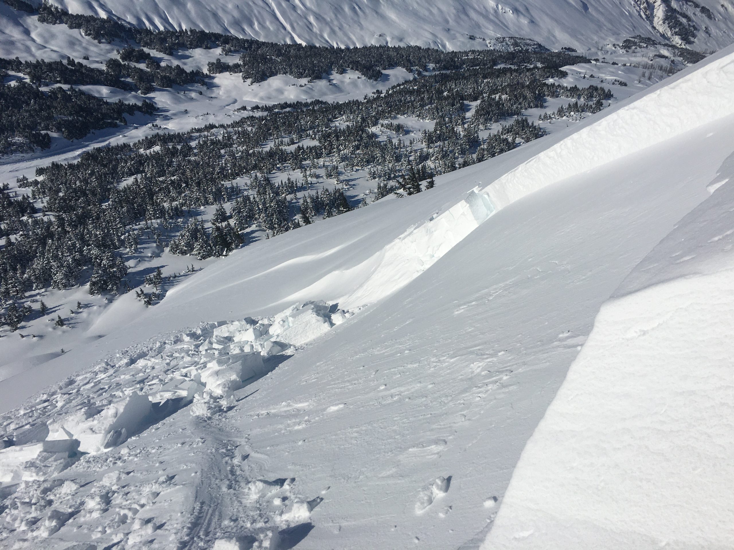
Remote-triggered avalanche that failed on a layer of buried surface hoar sitting on top of a melt-freeze crust. 03.12.2021

Weather
Sat, March 13th, 2021

Yesterday: We had plenty of sunshine yesterday, with clear skies and cool temperatures. High temperatures were in the single digits to upper teens F, with overnight lows down to -12 F near Summit Lake to just barely above 0 F in Girdwood and on Turnagain pass. Westerly ridgetop winds were sustained at 5-15 mph, with gusts to around 20 mph.

Today: Another day of clear skies and chilly temperatures is on tap today before active weather returns tomorrow. Highs are expected in the single digits to upper teens F, with lows in the single digits above and below 0 F. Westerly winds are expected to gradually decrease during the day, blowing 5-15 mph at ridgetops this morning.

Tomorrow: Cloud cover will increase early tomorrow morning, with the highest chance of precipitation late afternoon Sunday to early Monday morning. Winds will shift back to the southeast at 10-15 mph with gusts to 25 mph, and high temperatures are expected in the mid to upper teens F. Total snowfall is looking a bit more modest than our last storm, with around 6” expected by Monday morning. Stay tuned for updates!

PRECIPITATION 24-hour data (6am – 6am)

Temp Avg (F) Snow (in) Water (in) Snow Depth (in)
Center Ridge (1880′) 9 0 0 116
Summit Lake (1400′) 2 0 0 45
Alyeska Mid (1700′) 9 0 0 119

RIDGETOP 24-hour data (6am – 6am)

Temp Avg (F) Wind Dir Wind Avg (mph) Wind Gust (mph)
Sunburst (3812′) 1 W 9 21
Seattle Ridge (2400′) 5 N 3 10
Observations
Recent Observations for Turnagain Pass
Date Region Location
04/23/24 Turnagain Observation: Turnagain Sunny Side
04/21/24 Turnagain Observation: Bertha Creek
04/20/24 Turnagain Avalanche: Spokane Creek
04/16/24 Turnagain Observation: Cornbiscuit
04/15/24 Turnagain Observation: Taylor Pass
04/15/24 Turnagain Observation: Seward Highway – Tern Lake to Portage
04/14/24 Turnagain Observation: Sunburst
04/14/24 Turnagain Observation: Turnagain Pass Snomo
04/13/24 Turnagain Observation: Spokane Creek
04/11/24 Turnagain Observation: Tincan
Riding Areas

The riding areas page has moved. Please click here & update your bookmarks.


Subscribe to Turnagain Pass
Avalanche Forecast by Email

This is a general backcountry avalanche advisory issued for Turnagain Arm with Turnagain Pass as the core advisory area. This advisory does not apply to highways, railroads or operating ski areas.