Turnagain Pass RSS

Archives
ARCHIVED - Forecasts expire after 24 hours.
Issued
Fri, March 12th, 2021 - 7:00AM
Expires
Sat, March 13th, 2021 - 7:00AM
Forecaster
Graham Predeger
Avalanche risk The Bottom Line

There is a CONSIDERABLE avalanche danger above 1000’ due to fresh snow and moderate winds over the last two days.  Human triggered wind slabs 2-3’ deep are likely to be triggered today in areas affected by the wind.  Cautious route finding and conservative decision making will be essential.  Don’t let the draw of sunshine and fresh storm snow lure you or your crew into a bad spot today.  Below 1000′ and in areas unaffected by the wind the danger is MODERATE.

LOST LAKE/SNUG/SEWARD: Observers reported strong winds in Seward and Moose Pass yesterday with several small avalanches visible from the highway in steep, gullied (cross loaded) terrain.

Special Announcements

The ANCHORAGE FRONT RANGE received 16-20”+ of snow and moderate northwesterly winds Wednesday night and into Thursday.  Dangerous avalanche conditions exist.  2-3’+ wind slabs may be triggered  and have the potential to impact many popular hiking trails in addition to commonly skied terrain in and around Chugach State Park.

Fri, March 12th, 2021
Alpine
Above 2,500'
3 - Considerable
Avalanche risk
Treeline
1,000'-2,500'
3 - Considerable
Avalanche risk
Below Treeline
Below 1,000'
2 - Moderate
Avalanche risk
0 - No Rating
1 - Low
2 - Moderate
3 - Considerable
4 - High
5 - Extreme
Avalanche risk Avalanche risk Avalanche risk Avalanche risk Avalanche risk
Travel Advice Generally safe avalanche conditions. Watch for unstable snow on isolated terrain features. Heightened avalanche conditions on specific terrain features. Evaluate snow and terrain carefully; identify features of concern. Dangerous avalanche conditions. Careful snowpack evaluation, cautious route-finding, and conservative decision-making essential. Very dangerous avalanche conditions. Travel in avalanche terrain not recommended. Extraordinarily dangerous avalanche conditions. Avoid all avalanche terrain.
Likelihood of Avalanches Natural and human-triggered avalanches unlikely. Natural avalanches unlikely; human-triggered avalanches possible. Natural avalanches possible; human-triggered avalanches likely. Natural avalanches likely; human-triggered avalanches very likely. Natural and human-triggered avalanches certain.
Avalanche Size and Distribution Small avalanches in isolated areas or extreme terrain. Small avalanches in specific areas; or large avalanches in isolated areas. Small avalanches in many areas; or large avalanches in specific areas; or very large avalanches in isolated areas. Large avalanches in many areas; or very large avalanches in specific areas. Very large avalanches in many areas.
Avalanche Problem 1
  • Wind Slabs
    Wind Slabs
  • Certain
    Very Likely
    Likely
    Possible
    Unlikely
    Likelihood
  • Historic (D4-5)
    Very Large (D3)
    Large (D2)
    Small (D1)
    Size
Wind Slabs
Wind Slab avalanches are the release of a cohesive layer of snow (a slab) formed by the wind. Wind typically transports snow from the upwind sides of terrain features and deposits snow on the downwind side. Wind slabs are often smooth and rounded and sometimes sound hollow, and can range from soft to hard. Wind slabs that form over a persistent weak layer (surface hoar, depth hoar, or near-surface facets) may be termed Persistent Slabs or may develop into Persistent Slabs.

Likelihood of Avalanches
Terms such as "unlikely", "likely", and "certain" are used to define the scale, with the chance of triggering or observing avalanches increasing as we move up the scale. For our purposes, "Unlikely" means that few avalanches could be triggered in avalanche terrain and natural avalanches are not expected. "Certain" means that humans will be able to trigger avalanches on many slopes, and natural avalanches are expected.

Size of Avalanches
Avalanche size is defined by the largest potential avalanche, or expected range of sizes related to the problem in question. Assigned size is a qualitative estimate based on the destructive classification system and requires specialists to estimate the harm avalanches may cause to hypothetical objects located in the avalanche track (AAA 2016, CAA 2014). Under this schema, "Small" avalanches are not large enough to bury humans and are relatively harmless unless they carry people over cliffs or through trees or rocks. Moving up the scale, avalanches become "Large" enough to bury, injure, or kill people. "Very Large" avalanches may bury or destroy vehicles or houses, and "Historic" avalanches are massive events capable of altering the landscape.

Signal Word Size (D scale) Simple Descriptor
Small 1 Unlikely to bury a person
Large 2 Can bury a person
Very Large 3 Can destroy a house
Historic 4 & 5 Can destroy part or all of a village
More info at Avalanche.org

With sunshine on tap, Friday of Spring break week and a fresh blanket of snow, we can expect a busy day on the playground today.  Don’t lose sight of the fact that this week’s storm came in on a very weak surface and was accompanied by winds easily strong enough to transport the new snow.  As you gain in elevation and leave the shelter of the Forest and valleys below, expect to find wind slabs sensitive to human triggers.  My group was easily able to initiate wind slabs on small test slopes in the Lynx Creek area near tree line yesterday.  Similar results were found on test slopes in the Girdwood Valley.  These were breaking on the new/ old interface (18-24” down) on small, steep wind loaded slopes.  Look for stiffer snow and/ or shooting cracks from your skis or snowmachine to identify where the wind has left its mark.  Pay particular attention to unsupported slopes (convexities) and cross loaded gullies such as those on the front face of Seattle ridge.  These may prove a bit more stubborn today but are likely to be easier to initiate (and deeper) as you gain in elevation.  Quick hand pits or jumping on small non-consequential test slopes can further help you suss out these wind slabs and gauge reactivity.

Storm totals varied from 8” on the south end of Turnagain Pass to 16”+ on the north end between Wednesday morning and yesterday afternoon.  Winds were a constant and strong enough to easily transport the low-density storm snow into wind slabs above 1,000’.  The wind shut off pretty abruptly yesterday afternoon, though not til after some damage was done in the tree line and above elevations.  Today will be a day to sniff out any wind slabs and actively manage your terrain and your group.  As we roll into the best (and busiest) days of the season, communicate with, and be cognizant of adjacent parties, exposing only one person at a time to avalanche terrain.

A note on cornices:  They’re yuuuge right now.  Avoid these backcountry bombs as cornices are likely tender and may be easy to trigger from above today.

Persistent slabs: We’ve got a few weak, persistent layers deeper in the snowpack that we haven’t forgotten about.  There is a chance that a wind slab avalanche triggered near the surface overloads the older weak layers in the snowpack and steps down, creating a larger avalanche. This is another reason for extra caution today.

Sluffs: Steep slopes that are sheltered from the wind have a foot or more of new soft snow and a few inches of pre-storm facets. It will be easy to trigger dry loose avalanches (sluffs) in steep terrain unaffected by the wind.

Shooting cracks are a sure fire way to know you’ve found a wind slab.  photo: Paul Wunnicke

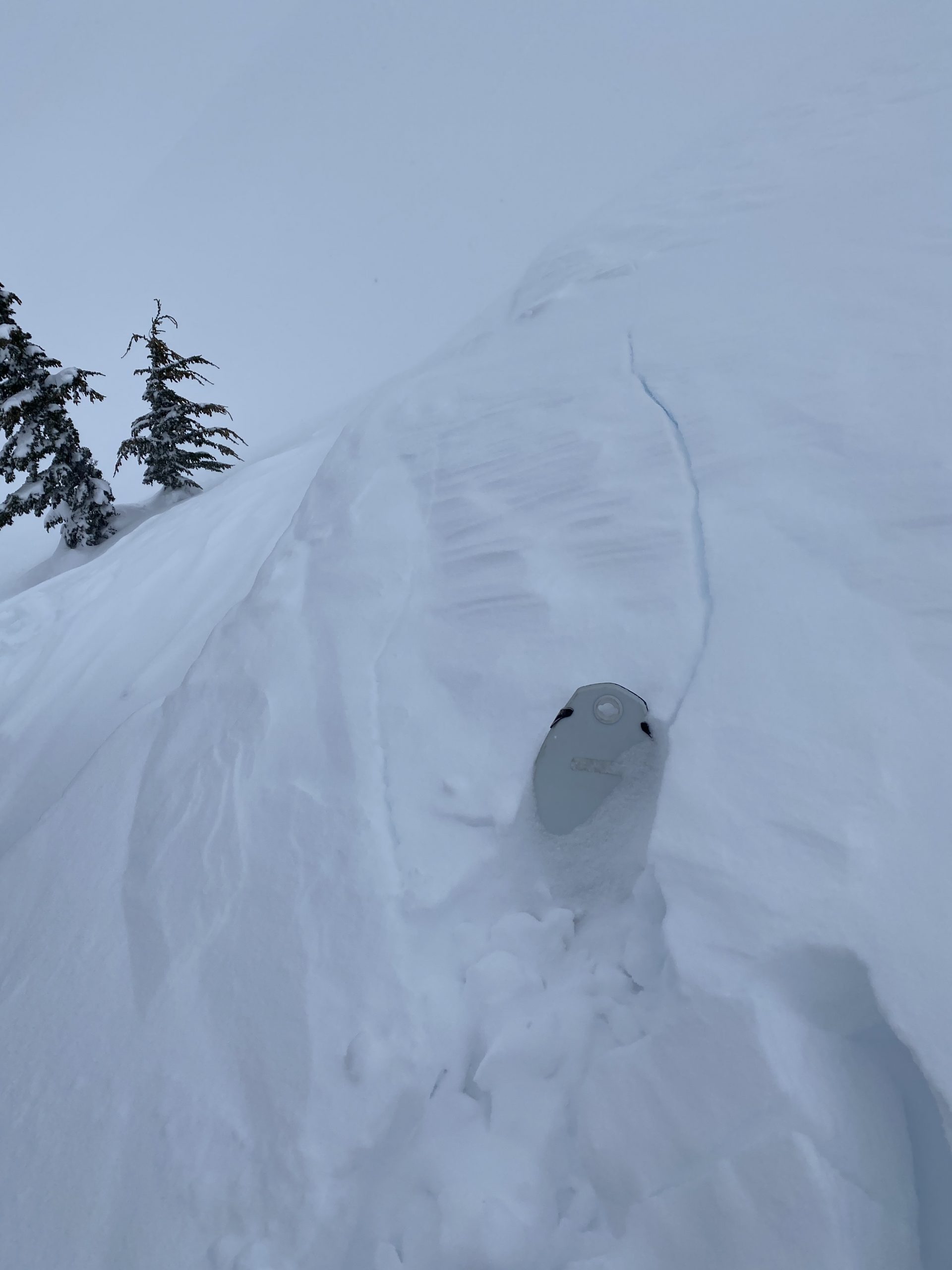
Small wind loaded test slope intentionally triggered by a snowmachine in the Lynx Creek drainage.

Weather
Fri, March 12th, 2021

Yesterday: Skies were obscured and light snow fell throughout the day with an additional 1-3” of accumulation.  Winds were blowing from the NW 15-30mph throughout most of the day before shutting off around 5pm.  Temperatures were in the mid-teens at 1,000’ and single digits to negative single digits at ridgetops.

Today: Cold, clear and calm sums up our weather forecast today.  Skies will be sunny and winds from the NW in the 5-20 mph range. Temps are hovering around zero at ridgetops and single digits at sea level this morning with not much change expected through the day.  Note: Low elevation due south aspects may feel some solar heating from direct sun today, even with cold ambient temps.

Tomorrow: More of the same tomorrow with light winds from the NW, clear skies and temps in the single to negative singe digits.  The next shot of weather is expected to arrive late Sunday afternoon with gusty SE winds, a warmer air mass and a decent chance for a few more inches of snow.  Stay tuned for more winter because according to the calendar, spring doesn’t technically arrive until March 20th!

PRECIPITATION 24-hour data (6am – 6am)

Temp Avg (F) Snow (in) Water (in) Snow Depth (in)
Center Ridge (1880′) 9 0 -.2* 117
Summit Lake (1400′) 7 0 0 45
Alyeska Mid (1700′) 8 4 .02* 120

*SWE under reporting likely due to winds affecting instruments.

RIDGETOP 24-hour data (6am – 6am)

Temp Avg (F) Wind Dir Wind Avg (mph) Wind Gust (mph)
Sunburst (3812′) -1 W 9 24
Seattle Ridge (2400′) 3 NW 5 25

Note: Seattle and SB weather stations tend to under report speed during W/NW wind events

Observations
Recent Observations for Turnagain Pass
Date Region Location
12/01/23 Avalanche: Sunburst
12/01/23 Turnagain Observation: Eddie’s trees
12/01/23 Turnagain Observation: Turnagain – God’s Country
11/30/23 Turnagain Avalanche: Tincan Trees
11/27/23 Turnagain Avalanche: Tincan Ridge
11/26/23 Turnagain Observation: Road report: Slide with dirt on Repeat offender
11/26/23 Turnagain Observation: Pete’s North
11/25/23 Turnagain Observation: Tincan trees
11/21/23 Observation: Spokane Creek
11/20/23 Turnagain Observation: Sunburst
Riding Areas

The riding areas page has moved. Please click here & update your bookmarks.


Subscribe to Turnagain Pass
Avalanche Forecast by Email

This is a general backcountry avalanche advisory issued for Turnagain Arm with Turnagain Pass as the core advisory area. This advisory does not apply to highways, railroads or operating ski areas.