Turnagain Pass RSS

Archives
ARCHIVED - Forecasts expire after 24 hours.
Issued
Sun, March 14th, 2021 - 7:00AM
Expires
Mon, March 15th, 2021 - 7:00AM
Forecaster
Wendy Wagner
Avalanche risk The Bottom Line

The avalanche danger remains MODERATE in the forecast area. An increase in easterly winds this afternoon, ahead of a storm system tonight, may begin to build new shallow wind slabs. Watch for active wind loading in the Alpine and avoid any fresh wind deposited snow. Additionally, triggering a slab avalanche between 1-3′ feet deep is still possible at all elevations. These slabs could also be triggered remotely (from the top, side or below) and are due to weak snow and/or sun crusts under Wednesday’s storm snow.

Special Announcements

Two human triggered avalanches were reported in Chugach State Park yesterday in the South Fork of Eagle River (Harp Mountain area). Several other naturally occurring avalanches were also seen in this zone. Please see those reports HERE. The Anchorage Front Range saw 16-20″ of snow with strong wind last week, which has increased avalanche danger.

Sun, March 14th, 2021
Alpine
Above 2,500'
2 - Moderate
Avalanche risk
Treeline
1,000'-2,500'
2 - Moderate
Avalanche risk
Below Treeline
Below 1,000'
2 - Moderate
Avalanche risk
0 - No Rating
1 - Low
2 - Moderate
3 - Considerable
4 - High
5 - Extreme
Avalanche risk Avalanche risk Avalanche risk Avalanche risk Avalanche risk
Travel Advice Generally safe avalanche conditions. Watch for unstable snow on isolated terrain features. Heightened avalanche conditions on specific terrain features. Evaluate snow and terrain carefully; identify features of concern. Dangerous avalanche conditions. Careful snowpack evaluation, cautious route-finding, and conservative decision-making essential. Very dangerous avalanche conditions. Travel in avalanche terrain not recommended. Extraordinarily dangerous avalanche conditions. Avoid all avalanche terrain.
Likelihood of Avalanches Natural and human-triggered avalanches unlikely. Natural avalanches unlikely; human-triggered avalanches possible. Natural avalanches possible; human-triggered avalanches likely. Natural avalanches likely; human-triggered avalanches very likely. Natural and human-triggered avalanches certain.
Avalanche Size and Distribution Small avalanches in isolated areas or extreme terrain. Small avalanches in specific areas; or large avalanches in isolated areas. Small avalanches in many areas; or large avalanches in specific areas; or very large avalanches in isolated areas. Large avalanches in many areas; or very large avalanches in specific areas. Very large avalanches in many areas.
Recent Avalanches

One small slab avalanche was reported in the forecast area yesterday.

Tincan’s Hippy Bowl: A skier/snowboarder triggered a small soft slab avalanche failing at the new/old snow interface, possibly on a sun crust. Slab was roughly 12-16″ deep, 30′ wide and running around 100′.

Tincan’s Hippy Bowl – Slab avalanche triggered be either a skier or snowboarder. Photo taken from Center Ridge parking lot by CNFAIC staff.

Avalanche Problem 1
  • Wind Slabs
    Wind Slabs
  • Certain
    Very Likely
    Likely
    Possible
    Unlikely
    Likelihood
  • Historic (D4-5)
    Very Large (D3)
    Large (D2)
    Small (D1)
    Size
Wind Slabs
Wind Slab avalanches are the release of a cohesive layer of snow (a slab) formed by the wind. Wind typically transports snow from the upwind sides of terrain features and deposits snow on the downwind side. Wind slabs are often smooth and rounded and sometimes sound hollow, and can range from soft to hard. Wind slabs that form over a persistent weak layer (surface hoar, depth hoar, or near-surface facets) may be termed Persistent Slabs or may develop into Persistent Slabs.

Likelihood of Avalanches
Terms such as "unlikely", "likely", and "certain" are used to define the scale, with the chance of triggering or observing avalanches increasing as we move up the scale. For our purposes, "Unlikely" means that few avalanches could be triggered in avalanche terrain and natural avalanches are not expected. "Certain" means that humans will be able to trigger avalanches on many slopes, and natural avalanches are expected.

Size of Avalanches
Avalanche size is defined by the largest potential avalanche, or expected range of sizes related to the problem in question. Assigned size is a qualitative estimate based on the destructive classification system and requires specialists to estimate the harm avalanches may cause to hypothetical objects located in the avalanche track (AAA 2016, CAA 2014). Under this schema, "Small" avalanches are not large enough to bury humans and are relatively harmless unless they carry people over cliffs or through trees or rocks. Moving up the scale, avalanches become "Large" enough to bury, injure, or kill people. "Very Large" avalanches may bury or destroy vehicles or houses, and "Historic" avalanches are massive events capable of altering the landscape.

Signal Word Size (D scale) Simple Descriptor
Small 1 Unlikely to bury a person
Large 2 Can bury a person
Very Large 3 Can destroy a house
Historic 4 & 5 Can destroy part or all of a village
More info at Avalanche.org

After a sunny and enjoyable break between storms, another weather system is moving in this afternoon. Clouds have already arrived and winds have switched around to the east. Light snowfall should begin this afternoon before peaking early tomorrow morning. Only an inch or so is expected by sunset, 2-4″ overnight, and another 2-4″ early in the day tomorrow (cross you fingers for a storm total close to 6-8″). Ridgetop winds are expected to slowly rise through the day and average up to 20-25mph by 4pm with stronger gusts. This will be enough to blow any soft surface snow into shallow wind slabs later today.

That said, pay attention to changing conditions. Keep an eye out for active wind loading and fresh wind slabs being formed. These are likely to be shallow and forming in the higher terrain. The usual signs of cracking in the snow around you and stiff snow over softer snow will be good clues for either finding a fresh slab or even an older one formed late last week. Those are concerning as well and discussed below in Problem #2.

Sluffs: Steep slopes with loose surface snow are sluffing easily.These can pick up enough volume and speed to carry a person. While it is unlikely they will be big enough to bury you, they can be dangerous if they drag you into terrain traps like cliffs, trees, rocks, or gullies.

Avalanche Problem 2
  • Persistent Slabs
    Persistent Slabs
  • Certain
    Very Likely
    Likely
    Possible
    Unlikely
    Likelihood
  • Historic (D4-5)
    Very Large (D3)
    Large (D2)
    Small (D1)
    Size
Persistent Slabs
Persistent Slab avalanches are the release of a cohesive layer of snow (a slab) in the middle to upper snowpack, when the bond to an underlying persistent weak layer breaks. Persistent layers include: surface hoar, depth hoar, near-surface facets, or faceted snow. Persistent weak layers can continue to produce avalanches for days, weeks or even months, making them especially dangerous and tricky. As additional snow and wind events build a thicker slab on top of the persistent weak layer, this avalanche problem may develop into a Deep Persistent Slab.

Likelihood of Avalanches
Terms such as "unlikely", "likely", and "certain" are used to define the scale, with the chance of triggering or observing avalanches increasing as we move up the scale. For our purposes, "Unlikely" means that few avalanches could be triggered in avalanche terrain and natural avalanches are not expected. "Certain" means that humans will be able to trigger avalanches on many slopes, and natural avalanches are expected.

Size of Avalanches
Avalanche size is defined by the largest potential avalanche, or expected range of sizes related to the problem in question. Assigned size is a qualitative estimate based on the destructive classification system and requires specialists to estimate the harm avalanches may cause to hypothetical objects located in the avalanche track (AAA 2016, CAA 2014). Under this schema, "Small" avalanches are not large enough to bury humans and are relatively harmless unless they carry people over cliffs or through trees or rocks. Moving up the scale, avalanches become "Large" enough to bury, injure, or kill people. "Very Large" avalanches may bury or destroy vehicles or houses, and "Historic" avalanches are massive events capable of altering the landscape.

Signal Word Size (D scale) Simple Descriptor
Small 1 Unlikely to bury a person
Large 2 Can bury a person
Very Large 3 Can destroy a house
Historic 4 & 5 Can destroy part or all of a village
More info at Avalanche.org

Triggering a larger slab avalanche 1-3′ deep is still a concern at all elevations. Wednesday’s snow is sitting on weak layers of facets and/or surface hoar as well as a slick sun crust on steep southerly slopes. All these buried layers are keeping Wednesday’s snow from bonding quickly. Furthermore, the northwest winds on Thursday into Friday created wind slabs of variable depth. Hence, finding and triggering a slab that is either shallow or up to 3′ deep should be on our minds.

Watching for signs of instability are key. These are whumpfing (collapsing) in the snowpack, cracking in the snow around you and any recent avalanches. All these signs have been reported over the past two days. The one piece of good news is the cold temperatures seem to be weakening the slab, which limits its ability to release. Also, some snow pit tests are pointing to Wednesday’s snow beginning to bond. Nonetheless, this avalanche problem is one that can fool us by allowing several people on the slope before it avalanches or avalanching remotely, meaning triggering a slab from the top, side or below. It’s still a heads up situation that requires close evaluation of every slope. Some slopes may show good stability while the next one over does not.

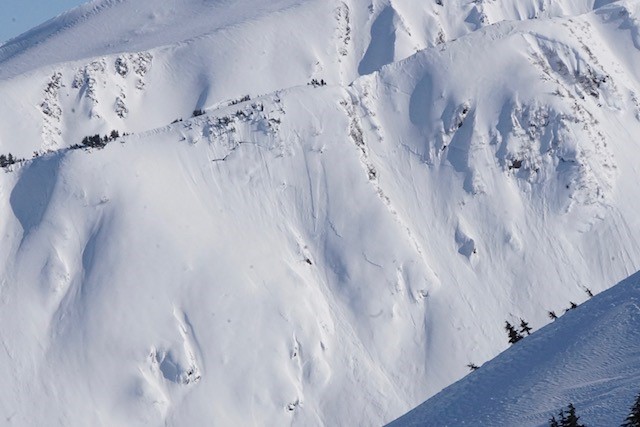
Several slab avalanches were seen on the north side of Eddies ridge yesterday (3/13). Note the skier/boarder tracks above the crowns and just under the trees. It is unknown if these were triggered remotely from above or if they were natural at the end of Wednesday’s storm or from the NW winds on Thursday. Photo: Heather Johnson (more photos here).


Check out this Hat Trick photo by Andy Moderow on the SW face of Shark’s Fin. 1- glide crack, 2- natural dry loose sluffs, and 3- natural slabs from late last week. 3.13.21.

Weather
Sun, March 14th, 2021

Yesterday:  Sunny skies were over the region with a light west to north breeze in the high terrain. Temperatures warmed from the single digits to the teens in most areas before dropping back down overnight. Ridgetop winds switched around to the east last night and are slowly picking up this morning (5-10mph at 6am).

Today:  Clouds are streaming in this morning ahead of the next weather system pushing in later today. Light snow is expected to begin falling in the afternoon with increasing easterly ridgetop winds. By 4pm expect east winds in the Alpine to be in the 20-25mph range and by midnight tonight up to 30mph averages. Only an inch of snow is expected by sunset with an additional 2-4″ (.25 SWE) by tomorrow morning. Temperatures will remain cold (in the teens to 20’sF) with snow to sea level.

Tomorrow:  Snowfall is expected to continue through tomorrow afternoon with another 2-4″ falling in the earlier part of the day. Temperatures remain in the 20’sF to teens and snow should fall to sea level. Ridgetop winds will do a quick 180 in the morning and look to blow 5-15mph from the NW tomorrow.

PRECIPITATION 24-hour data (6am – 6am)

Temp Avg (F) Snow (in) Water (in) Snow Depth (in)
Center Ridge (1880′) 7 0 0 115
Summit Lake (1400′) -1 0 0 45
Alyeska Mid (1700′) 9 0 0 118

RIDGETOP 24-hour data (6am – 6am)

Temp Avg (F) Wind Dir Wind Avg (mph) Wind Gust (mph)
Sunburst (3812′) 12 W 5 15
Seattle Ridge (2400′) 8 NE 5 14
Observations
Recent Observations for Turnagain Pass
Date Region Location
04/23/24 Turnagain Observation: Turnagain Sunny Side
04/21/24 Turnagain Observation: Bertha Creek
04/20/24 Turnagain Avalanche: Spokane Creek
04/16/24 Turnagain Observation: Cornbiscuit
04/15/24 Turnagain Observation: Taylor Pass
04/15/24 Turnagain Observation: Seward Highway – Tern Lake to Portage
04/14/24 Turnagain Observation: Sunburst
04/14/24 Turnagain Observation: Turnagain Pass Snomo
04/13/24 Turnagain Observation: Spokane Creek
04/11/24 Turnagain Observation: Tincan
Riding Areas

The riding areas page has moved. Please click here & update your bookmarks.


Subscribe to Turnagain Pass
Avalanche Forecast by Email

This is a general backcountry avalanche advisory issued for Turnagain Arm with Turnagain Pass as the core advisory area. This advisory does not apply to highways, railroads or operating ski areas.