Turnagain Pass RSS

Archives
ARCHIVED - Forecasts expire after 24 hours.
Issued
Sat, February 26th, 2022 - 7:00AM
Expires
Sun, February 27th, 2022 - 7:00AM
Forecaster
John Sykes
Avalanche risk The Bottom Line

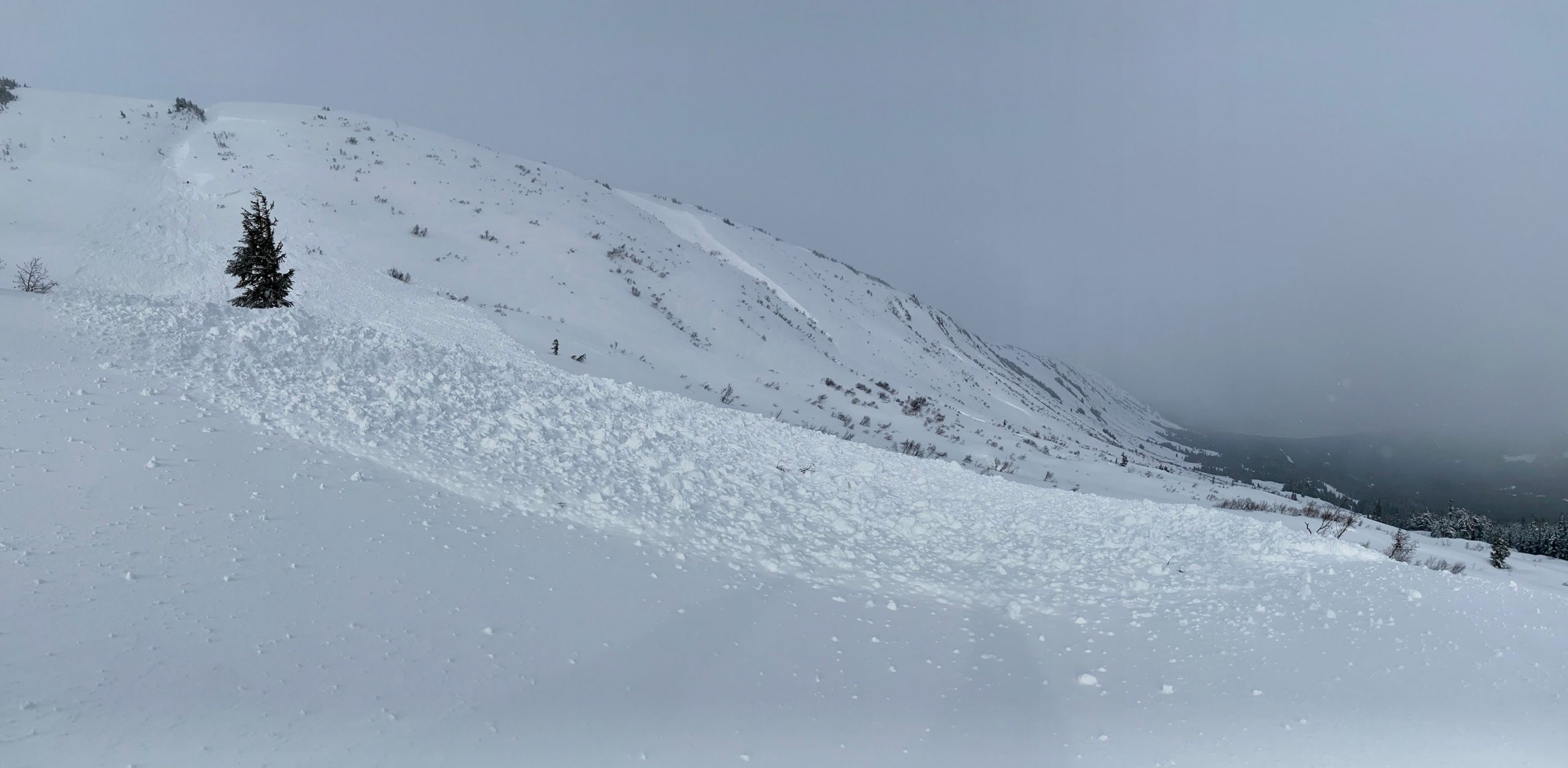
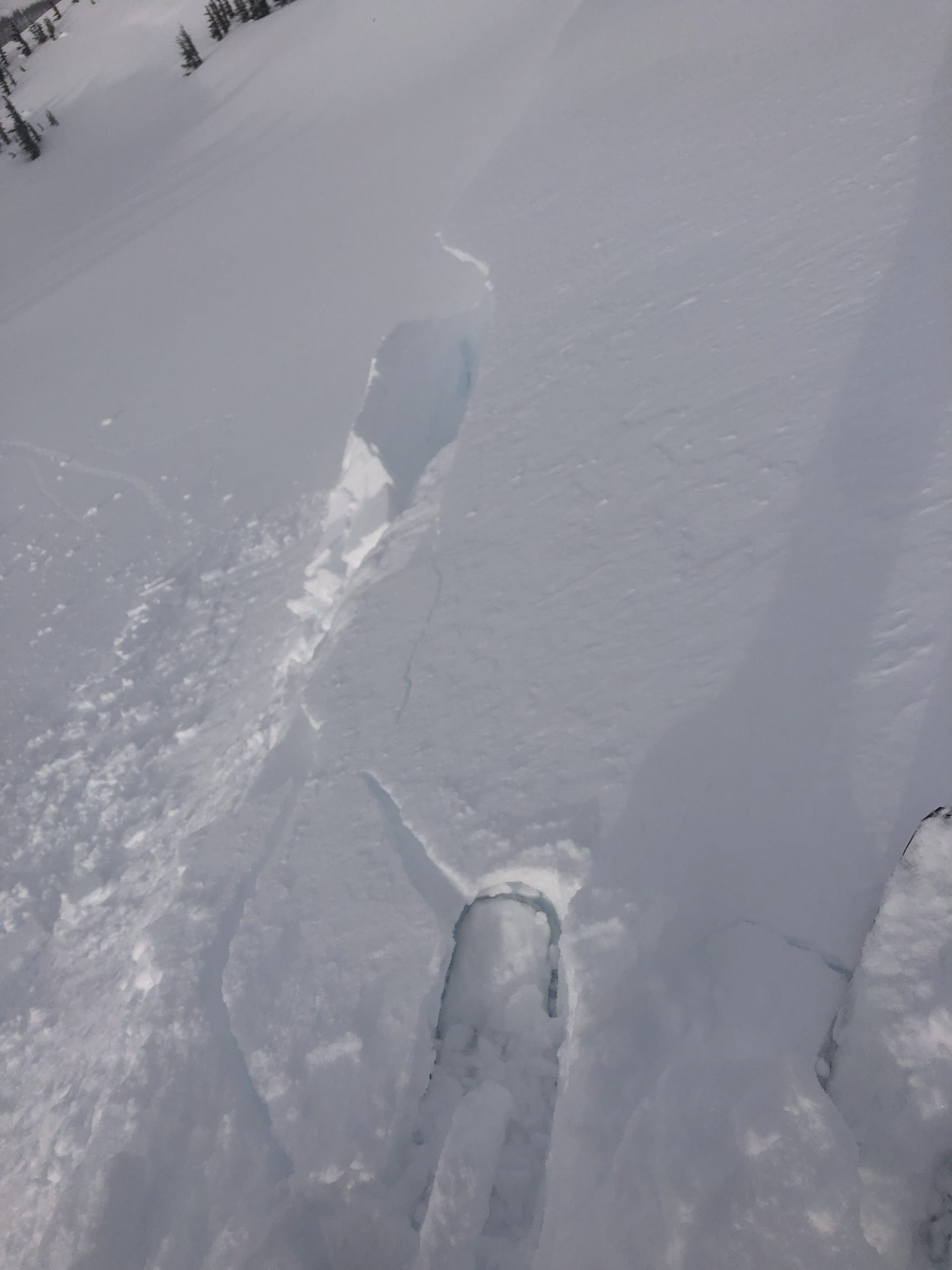
The avalanche danger is CONSIDERABLE above 2500′, where lingering wind slabs up to 3′ deep are likely for a person to trigger today. Very strong easterly winds created fresh wind slabs over the past 24 hours which could exist lower down on leeward slopes than normal due to the strength of the winds. In areas with a thinner snowpack buried weak layers have the potential to produce large avalanches. Below 2500′ the avalanche danger is MODERATE where lighter winds have created more isolated pockets of wind slab.

PORTAGE/PLACER: These areas with more coastal influence received 2-3 times as much snow as Turnagain Pass over the past two days. Wind slabs could be up to 6′ deep in these areas and the potential exists for avalanches within the storm snow in wind protected areas.

SUMMIT LAKE: A thin snowpack throughout the Summit Lake area has created multiple buried weak layers that could be reactive to human triggers with the addition of fresh wind slabs during the recent storm. Careful evaluation of the snowpack is recommended.

SEWARD/LOST LAKE/SNUG HARBOR – Several observations of recent avalanches from the Seward and Moose Pass area during the recent storm. New snow and wind loading have likely created increased avalanche hazard at higher elevations.

Special Announcements
  • AK DOT will have intermittent traffic delays Saturday February 26, 2022 on the Seward Highway and Portage Glacier Highway for Avalanche Hazard Reduction work. From mileposts 88 to 85 on the Seward Highway, South of Girdwood. Near mile Post 5 and Bear Valley on the Portage Glacier Highway. Motorists should expect delays of up to 45 minutes between 09:00 AM and 2:00 PM.
Sat, February 26th, 2022
Alpine
Above 2,500'
3 - Considerable
Avalanche risk
Treeline
1,000'-2,500'
2 - Moderate
Avalanche risk
Below Treeline
Below 1,000'
2 - Moderate
Avalanche risk
0 - No Rating
1 - Low
2 - Moderate
3 - Considerable
4 - High
5 - Extreme
Avalanche risk Avalanche risk Avalanche risk Avalanche risk Avalanche risk
Travel Advice Generally safe avalanche conditions. Watch for unstable snow on isolated terrain features. Heightened avalanche conditions on specific terrain features. Evaluate snow and terrain carefully; identify features of concern. Dangerous avalanche conditions. Careful snowpack evaluation, cautious route-finding, and conservative decision-making essential. Very dangerous avalanche conditions. Travel in avalanche terrain not recommended. Extraordinarily dangerous avalanche conditions. Avoid all avalanche terrain.
Likelihood of Avalanches Natural and human-triggered avalanches unlikely. Natural avalanches unlikely; human-triggered avalanches possible. Natural avalanches possible; human-triggered avalanches likely. Natural avalanches likely; human-triggered avalanches very likely. Natural and human-triggered avalanches certain.
Avalanche Size and Distribution Small avalanches in isolated areas or extreme terrain. Small avalanches in specific areas; or large avalanches in isolated areas. Small avalanches in many areas; or large avalanches in specific areas; or very large avalanches in isolated areas. Large avalanches in many areas; or very large avalanches in specific areas. Very large avalanches in many areas.
Recent Avalanches

Seattle Ridge – Several recent avalanches along Seattle ridge yesterday which appeared to be from cross loaded wind slabs. We saw two debris piles that were big enough to bury a person along the far southern end of Seattle ridge across from the Johnson Pass trailhead and one fresh debris pile just north of the Seattle Ridge uptrack (photo below).

Natural avalanche just north of Seattle Ridge uptrack that released due to wind loading across the face of Seattle Ridge. This was a D2, which means it was large enough to fully bury a person. Photo 2.25.22

Avalanche Problem 1
  • Wind Slabs
    Wind Slabs
  • Certain
    Very Likely
    Likely
    Possible
    Unlikely
    Likelihood
  • Historic (D4-5)
    Very Large (D3)
    Large (D2)
    Small (D1)
    Size
Wind Slabs
Wind Slab avalanches are the release of a cohesive layer of snow (a slab) formed by the wind. Wind typically transports snow from the upwind sides of terrain features and deposits snow on the downwind side. Wind slabs are often smooth and rounded and sometimes sound hollow, and can range from soft to hard. Wind slabs that form over a persistent weak layer (surface hoar, depth hoar, or near-surface facets) may be termed Persistent Slabs or may develop into Persistent Slabs.

Likelihood of Avalanches
Terms such as "unlikely", "likely", and "certain" are used to define the scale, with the chance of triggering or observing avalanches increasing as we move up the scale. For our purposes, "Unlikely" means that few avalanches could be triggered in avalanche terrain and natural avalanches are not expected. "Certain" means that humans will be able to trigger avalanches on many slopes, and natural avalanches are expected.

Size of Avalanches
Avalanche size is defined by the largest potential avalanche, or expected range of sizes related to the problem in question. Assigned size is a qualitative estimate based on the destructive classification system and requires specialists to estimate the harm avalanches may cause to hypothetical objects located in the avalanche track (AAA 2016, CAA 2014). Under this schema, "Small" avalanches are not large enough to bury humans and are relatively harmless unless they carry people over cliffs or through trees or rocks. Moving up the scale, avalanches become "Large" enough to bury, injure, or kill people. "Very Large" avalanches may bury or destroy vehicles or houses, and "Historic" avalanches are massive events capable of altering the landscape.

Signal Word Size (D scale) Simple Descriptor
Small 1 Unlikely to bury a person
Large 2 Can bury a person
Very Large 3 Can destroy a house
Historic 4 & 5 Can destroy part or all of a village
More info at Avalanche.org

The major snowfall event that was supposed to take place over the past 48 hours was a bit of a dud, producing less than half the expected snowfall. We ended up with roughly 1″ of water at Turnagain Pass and Girdwood over the past 2 days, which translates to 6-12″ of wet to moist snow. In areas closer to the coast, like Portage and Placer, snowfall totals from the past 48 hours are likely double or triple what we have observed at Turnagain Pass and snowfall is expected to continue to trickle in today. The storm did produce some impressive winds with averages of 50-70 mph on ridgetops during the first half of the day yesterday and gusts up to 120 mph.

The primary avalanche problem today is wind slabs 1-3′ deep in Turnagain Pass and Girdwood and 2-6′ deep in Portage and Placer. We saw evidence of wind slabs releasing naturally yesterday and creating avalanches that are big enough to bury a person (see recent avalanches). Today the potential for natural avalanches is much lower as the wind and snowfall have decreased significantly, but human triggered avalanches are still likely in wind loaded areas. We recommend easing into steeper terrain today and evaluating how well the new snow is bonding with the old snow surface. Looking for shooting cracks, hollow feeling snow, and signs of recent wind transport on the snow surface are all good ways to identify areas with lingering wind slabs.

In areas with a shallow snowpack, such as Crow Creek, Lynx Creek, Silvertip, and the south end of Seattle Ridge, there are buried weak layers that could produce larger avalanches and need to be evaluated carefully (see problem 2 for more details).

Cornices: The new snow and strong winds the past two days will have added some mass to our already large cornices throughout the area. Be aware that cornices could be more reactive to human triggers today so try to avoid spending time underneath them and give them a wide berth along ridgelines.

Loose Snow Avalanches: The surface snow was moist and sticky up to 2000′ yesterday so we did not have any loose snow avalanches, but at higher elevations where the snow is drier it is possible that sluffs on steeper terrain will be an issue today. In addition, warm temperatures at lower elevations or solar warming could cause wet loose avalanches in the new snow.

Shooting cracks on wind loaded features in Tincan trees yesterday. We also had propagation on an ECT with 9 taps (ECT P 9) indicating that the fresh wind slabs were reactive. Photo 2.25.22

The sun poked through yesterday afternoon, and we were somewhat surprised that we did not see much avalanche activity. Plenty of snow being transported along ridgelines though! Photo 2.25.22

Avalanche Problem 2
  • Persistent Slabs
    Persistent Slabs
  • Certain
    Very Likely
    Likely
    Possible
    Unlikely
    Likelihood
  • Historic (D4-5)
    Very Large (D3)
    Large (D2)
    Small (D1)
    Size
Persistent Slabs
Persistent Slab avalanches are the release of a cohesive layer of snow (a slab) in the middle to upper snowpack, when the bond to an underlying persistent weak layer breaks. Persistent layers include: surface hoar, depth hoar, near-surface facets, or faceted snow. Persistent weak layers can continue to produce avalanches for days, weeks or even months, making them especially dangerous and tricky. As additional snow and wind events build a thicker slab on top of the persistent weak layer, this avalanche problem may develop into a Deep Persistent Slab.

Likelihood of Avalanches
Terms such as "unlikely", "likely", and "certain" are used to define the scale, with the chance of triggering or observing avalanches increasing as we move up the scale. For our purposes, "Unlikely" means that few avalanches could be triggered in avalanche terrain and natural avalanches are not expected. "Certain" means that humans will be able to trigger avalanches on many slopes, and natural avalanches are expected.

Size of Avalanches
Avalanche size is defined by the largest potential avalanche, or expected range of sizes related to the problem in question. Assigned size is a qualitative estimate based on the destructive classification system and requires specialists to estimate the harm avalanches may cause to hypothetical objects located in the avalanche track (AAA 2016, CAA 2014). Under this schema, "Small" avalanches are not large enough to bury humans and are relatively harmless unless they carry people over cliffs or through trees or rocks. Moving up the scale, avalanches become "Large" enough to bury, injure, or kill people. "Very Large" avalanches may bury or destroy vehicles or houses, and "Historic" avalanches are massive events capable of altering the landscape.

Signal Word Size (D scale) Simple Descriptor
Small 1 Unlikely to bury a person
Large 2 Can bury a person
Very Large 3 Can destroy a house
Historic 4 & 5 Can destroy part or all of a village
More info at Avalanche.org

There is a dramatic difference in the snowpack structure between deeper versus shallower snowpack areas across the forecast zone. In deeper snowpack areas, like near Alyeska in Girdwood and Turnagain Pass, recent avalanche activity has been limited to storm snow instabilities which have been relatively quick to heal after the past few snowfall events. In shallower snowpack areas, like Crow Creek in Girdwood and Lynx Creek on the far southern end of Turnagain Pass, we have seen wide propagation and deeper crown heights during recent storms which indicate that buried weak layers are able to be reactivated by new snow loading. Similar weak snowpack structure exists in the Summit Lake area, which is outside our forecast zone.

There are several potential buried persistent weak layers in these areas, but the most concerning are facets from November which are the likely culprit for large natural avalanches along Penguin Ridge and Crow Creek in Girdwood and potentially the cause of large avalanches in Lynx creek. We don’t know if it is possible for a person to trigger an avalanche on these deeper weak layers but the consequences of being involved with an avalanche of this size are severe, so we recommend careful evaluation of the snowpack and terrain as well as conservative decision-making in areas harboring these persistent weak layers.

Weather
Sat, February 26th, 2022

Yesterday: Moderate to heavy snowfall during the morning tapering off into the afternoon. Winds were very strong through the afternoon with averages in the 50-70 mph range and gusts up to 120 mph at ridgetops. Winds decreased drastically around 6 pm and have been averaging 5-15 mph with gusts into the 20-30 mph range since. Temperatures were warm yesterday, with snow line around 700′ and moist snow falling up to 2000′.

Today: Snow flurries expected throughout the day with up to an inch of accumulation for Turnagain Pass and Girdwood. Portage and Placer may still see a few inches of snow accumulation, especially in areas closer to the coast. Temperatures will hold steady in mid 20s at upper elevations and 30s at lower elevations. Snow line is estimated at 600-900′ today. Winds will remain light at 5-15 mph with gusts possible up to 30 mph.

Tomorrow: Sunday looks similar to today, with potential for snow flurries and cloud cover throughout the day. Light to calm winds and temperatures decreasing slightly and dropping below freezing at lower elevations.

PRECIPITATION 24-hour data (6am – 6am)

Temp Avg (F) Snow (in) Water (in) Snow Depth (in)
Center Ridge (1880′) 32 3 0.4 97
Summit Lake (1400′) 35 0 0 42
Alyeska Mid (1700′) 32 4 0.4 NA

RIDGETOP 24-hour data (6am – 6am)

Temp Avg (F) Wind Dir Wind Avg (mph) Wind Gust (mph)
Sunburst (3812′) 22 ENE 36 120
Seattle Ridge (2400′) 26 SE 15 50
Observations
Recent Observations for Turnagain Pass
Date Region Location
04/16/24 Turnagain Observation: Cornbiscuit
04/15/24 Turnagain Observation: Taylor Pass
04/15/24 Turnagain Observation: Seward Highway – Tern Lake to Portage
04/14/24 Turnagain Observation: Sunburst
04/14/24 Turnagain Observation: Turnagain Pass Snomo
04/13/24 Turnagain Observation: Spokane Creek
04/11/24 Turnagain Observation: Tincan
04/10/24 Turnagain Avalanche: Seattle Ridge
04/10/24 Turnagain Observation: Cornbiscuit South Face
04/10/24 Turnagain Avalanche: Tincan
Riding Areas

The riding areas page has moved. Please click here & update your bookmarks.


Subscribe to Turnagain Pass
Avalanche Forecast by Email

This is a general backcountry avalanche advisory issued for Turnagain Arm with Turnagain Pass as the core advisory area. This advisory does not apply to highways, railroads or operating ski areas.