Turnagain Pass RSS

Archives
ARCHIVED - Forecasts expire after 24 hours.
Issued
Sun, February 27th, 2022 - 7:00AM
Expires
Mon, February 28th, 2022 - 7:00AM
Forecaster
John Sykes
Avalanche risk The Bottom Line

The avalanche danger is MODERATE above 1000′. Lingering wind slabs up to 3′ deep from the very strong east winds on Friday are still possible for a person to trigger today. The most likely place to find a wind slab is along upper elevation ridgelines, cross loaded gullies, and convex rolls. Warming temperatures this afternoon could also lead to wet loose avalanches on steep terrain below 2000′. Below 1000′ the avalanche danger is LOW.

SUMMIT LAKE: This region has a much thinner and weaker snowpack compared to Turnagain. Avalanches are more likely to step down into buried weak layers and create a larger and more dangerous slide.

Sun, February 27th, 2022
Alpine
Above 2,500'
2 - Moderate
Avalanche risk
Treeline
1,000'-2,500'
2 - Moderate
Avalanche risk
Below Treeline
Below 1,000'
1 - Low
Avalanche risk
0 - No Rating
1 - Low
2 - Moderate
3 - Considerable
4 - High
5 - Extreme
Avalanche risk Avalanche risk Avalanche risk Avalanche risk Avalanche risk
Travel Advice Generally safe avalanche conditions. Watch for unstable snow on isolated terrain features. Heightened avalanche conditions on specific terrain features. Evaluate snow and terrain carefully; identify features of concern. Dangerous avalanche conditions. Careful snowpack evaluation, cautious route-finding, and conservative decision-making essential. Very dangerous avalanche conditions. Travel in avalanche terrain not recommended. Extraordinarily dangerous avalanche conditions. Avoid all avalanche terrain.
Likelihood of Avalanches Natural and human-triggered avalanches unlikely. Natural avalanches unlikely; human-triggered avalanches possible. Natural avalanches possible; human-triggered avalanches likely. Natural avalanches likely; human-triggered avalanches very likely. Natural and human-triggered avalanches certain.
Avalanche Size and Distribution Small avalanches in isolated areas or extreme terrain. Small avalanches in specific areas; or large avalanches in isolated areas. Small avalanches in many areas; or large avalanches in specific areas; or very large avalanches in isolated areas. Large avalanches in many areas; or very large avalanches in specific areas. Very large avalanches in many areas.
Recent Avalanches
  • Girdwood – A large avalanche was triggered using explosives during avalanche mitigation in the cat ski area on the Sunnyside of Notch Peak yesterday. The avalanche ranged from 2-8′ deep at the crown and may have stepped down onto some kind of buried weak layer but there was no obvious persistent weak layer at the bed surface.
Avalanche Problem 1
  • Wind Slabs
    Wind Slabs
  • Certain
    Very Likely
    Likely
    Possible
    Unlikely
    Likelihood
  • Historic (D4-5)
    Very Large (D3)
    Large (D2)
    Small (D1)
    Size
Wind Slabs
Wind Slab avalanches are the release of a cohesive layer of snow (a slab) formed by the wind. Wind typically transports snow from the upwind sides of terrain features and deposits snow on the downwind side. Wind slabs are often smooth and rounded and sometimes sound hollow, and can range from soft to hard. Wind slabs that form over a persistent weak layer (surface hoar, depth hoar, or near-surface facets) may be termed Persistent Slabs or may develop into Persistent Slabs.

Likelihood of Avalanches
Terms such as "unlikely", "likely", and "certain" are used to define the scale, with the chance of triggering or observing avalanches increasing as we move up the scale. For our purposes, "Unlikely" means that few avalanches could be triggered in avalanche terrain and natural avalanches are not expected. "Certain" means that humans will be able to trigger avalanches on many slopes, and natural avalanches are expected.

Size of Avalanches
Avalanche size is defined by the largest potential avalanche, or expected range of sizes related to the problem in question. Assigned size is a qualitative estimate based on the destructive classification system and requires specialists to estimate the harm avalanches may cause to hypothetical objects located in the avalanche track (AAA 2016, CAA 2014). Under this schema, "Small" avalanches are not large enough to bury humans and are relatively harmless unless they carry people over cliffs or through trees or rocks. Moving up the scale, avalanches become "Large" enough to bury, injure, or kill people. "Very Large" avalanches may bury or destroy vehicles or houses, and "Historic" avalanches are massive events capable of altering the landscape.

Signal Word Size (D scale) Simple Descriptor
Small 1 Unlikely to bury a person
Large 2 Can bury a person
Very Large 3 Can destroy a house
Historic 4 & 5 Can destroy part or all of a village
More info at Avalanche.org

Another day of light winds and warm temperatures is on tap today, with visibility potentially the biggest challenge for mountain travel again. Human triggered avalanches are possible in areas with lingering wind slabs up to 3′ deep, but we expect they will be stubborn to trigger now that the snowpack has had some extra time to adjust to the new snow and wind loading from Thursday and Friday. The most likely place to find a lingering wind slab that could produce an avalanche is along upper elevation ridgelines, cross loaded gullies, and convex rollovers. Temperatures got pretty warm yesterday, with freezing level creeping up to about 2000′ which created some moist snow on the surface that should add strength to the upper snowpack as it freezes.

Wet Loose: The warm temperatures yesterday afternoon created prime conditions for roller balls which is a sign that wet loose avalanches are likely in steeper terrain. If the temperatures rise again this afternoon then expect wet snow at the surface to be creating roller balls and wet loose avalanches again. In general these are not large enough to bury a person, but can be heavier than expected and push you around.

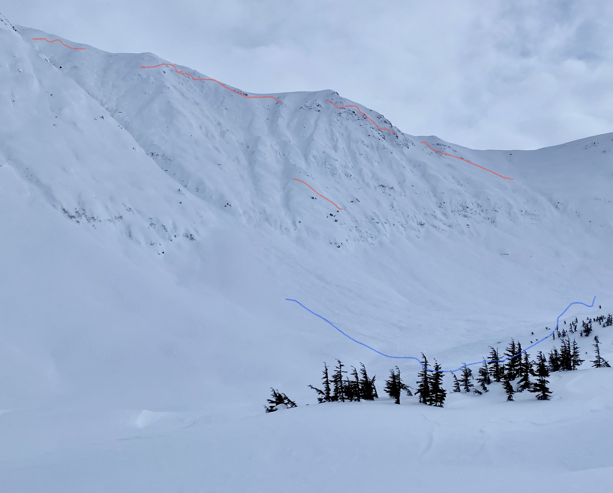
Glide: Another fresh glide crack was observed above the Seattle Ridge up track yesterday. These are a familiar sight this year, but it is important to remember that they can release randomly and cause very large and destructive avalanches. It is best to minimize time spent underneath them.

Shooting crack on a wind loaded slope at upper elevations on Tincan yesterday. Photo from Andy Moderow 2.26.22

Fresh glide crack above Seattle Creek up track that appeared yesterday. Photo from Andy Moderow 2.26.22


Avalanche Problem 2
  • Persistent Slabs
    Persistent Slabs
  • Certain
    Very Likely
    Likely
    Possible
    Unlikely
    Likelihood
  • Historic (D4-5)
    Very Large (D3)
    Large (D2)
    Small (D1)
    Size
Persistent Slabs
Persistent Slab avalanches are the release of a cohesive layer of snow (a slab) in the middle to upper snowpack, when the bond to an underlying persistent weak layer breaks. Persistent layers include: surface hoar, depth hoar, near-surface facets, or faceted snow. Persistent weak layers can continue to produce avalanches for days, weeks or even months, making them especially dangerous and tricky. As additional snow and wind events build a thicker slab on top of the persistent weak layer, this avalanche problem may develop into a Deep Persistent Slab.

Likelihood of Avalanches
Terms such as "unlikely", "likely", and "certain" are used to define the scale, with the chance of triggering or observing avalanches increasing as we move up the scale. For our purposes, "Unlikely" means that few avalanches could be triggered in avalanche terrain and natural avalanches are not expected. "Certain" means that humans will be able to trigger avalanches on many slopes, and natural avalanches are expected.

Size of Avalanches
Avalanche size is defined by the largest potential avalanche, or expected range of sizes related to the problem in question. Assigned size is a qualitative estimate based on the destructive classification system and requires specialists to estimate the harm avalanches may cause to hypothetical objects located in the avalanche track (AAA 2016, CAA 2014). Under this schema, "Small" avalanches are not large enough to bury humans and are relatively harmless unless they carry people over cliffs or through trees or rocks. Moving up the scale, avalanches become "Large" enough to bury, injure, or kill people. "Very Large" avalanches may bury or destroy vehicles or houses, and "Historic" avalanches are massive events capable of altering the landscape.

Signal Word Size (D scale) Simple Descriptor
Small 1 Unlikely to bury a person
Large 2 Can bury a person
Very Large 3 Can destroy a house
Historic 4 & 5 Can destroy part or all of a village
More info at Avalanche.org

A few larger avalanches were observed in Lynx Creek and Goldpan yesterday that likely released during the strong winds and snowfall on Friday. These had wider propagation than most of the activity we observed during the last storm and may have stepped down to an older layer but were probably not deep enough to have involved the November facets that we are most concerned about. An explosive triggered avalanche on the Sunnyside of Notch Peak in Girdwood had an alarming crown depth ranging from 2-8′ deep, but we are not sure whether there was a persistent weak layer involved or if it was just a very deep wind loaded pocket.

The snowpack has had some time to adjust to the new load, which will decrease the likelihood of triggering an avalanche on a deeper weak layer. In general, we recommend carefully evaluating the snowpack for persistent weak layers if you are travelling in avalanche terrain in an area with a shallow snowpack (less than ~6′ deep), such as Crow Creek, Lynx Creek, or Silvertip Creek. We have observed widespread weak snowpack structure in these shallow areas and the potential exists for large and wide propagating avalanches. Due to the depth of the weak layers and strength of the upper snowpack the chances are pretty low for a person to trigger an avalanche on a deeper weak layer without some kind of larger trigger, like a cornice fall or another avalanche. However, the consequences of triggering an avalanche on one of these layers could be very high so we are continuing to monitor and evaluate the distribution of these weak layers.

Larger avalanche in Goldpan area that appeared to have stepped down into an older layer. Photo 2.26.22

Another larger avalanche from Lynx Creek that produced a lot of debris, but may have just been a series of large and well connected wind slabs. Photo 2.26.22

Weather
Sun, February 27th, 2022

Yesterday: Broken to overcast sky cover with light winds and warms temps, with freezing levels climbing up to roughly 2000′.

Today: Another day of variable cloud cover, light winds, and mild temperatures. No snowfall expected today.

Tomorrow: Overnight there is a chance of a few inches of snowfall tapering off Monday afternoon. Winds remain light through the next few days with temperatures dropping slightly. Currently this week looks pretty quiet on the weather front, with light winds and mid level clouds lingering in the area.

PRECIPITATION 24-hour data (6am – 6am)

Temp Avg (F) Snow (in) Water (in) Snow Depth (in)
Center Ridge (1880′) 33 0 0 95
Summit Lake (1400′) 32 0 0 42
Alyeska Mid (1700′) 33 0 0 NA

RIDGETOP 24-hour data (6am – 6am)

Temp Avg (F) Wind Dir Wind Avg (mph) Wind Gust (mph)
Sunburst (3812′) 24 ENE 5 19
Seattle Ridge (2400′) 28 NA NA NA

*Rime on Seattle Ridge weather station is blocking the wind sensor

Observations
Recent Observations for Turnagain Pass
Date Region Location
10/27/24 Turnagain Observation: Tincan
10/21/24 Turnagain Observation: Turnagain Pass Road Observation
10/19/24 Turnagain Observation: Tincan – Below Todds Run
10/18/24 Turnagain Observation: Taylor Pass
10/15/24 Turnagain Observation: Tincan Common
10/14/24 Turnagain Avalanche: Tincan
05/13/24 Turnagain Observation: Eddie’s, Sunburst, Seattle, Cornbiscuit, Pete’s South
05/13/24 Turnagain Observation: Turnagain Pass non-motorized side
05/12/24 Turnagain Observation: Warm up Bowl
05/07/24 Turnagain Observation: Turnagain Pass Wet Slabs
Riding Areas

The riding areas page has moved. Please click here & update your bookmarks.


Subscribe to Turnagain Pass
Avalanche Forecast by Email

This is a general backcountry avalanche advisory issued for Turnagain Arm with Turnagain Pass as the core advisory area. This advisory does not apply to highways, railroads or operating ski areas.