Turnagain Pass RSS

Archives
ARCHIVED - Forecasts expire after 24 hours.
Issued
Mon, February 1st, 2021 - 7:00AM
Expires
Tue, February 2nd, 2021 - 7:00AM
Forecaster
Aleph Johnston-Bloom
Avalanche risk The Bottom Line

The avalanche danger is MODERATE above 1000’. Triggering a slab avalanche 1-2′ deep is possible on wind-loaded slopes. Light to moderate winds over the past few days have been able to drift the snow at the surface into sensitive slabs on top of fragile weak layers that formed last week.  Today it will be important to recognize and avoid wind-loaded terrain. Give cornices a wide berth, limit time spent under glide cracks and watch your sluff.

The avalanche danger is LOW below 1000’.

PLACER/PORTAGE VALLEY/WHITTIER: This area received 12-18″ snow with the most recent storm, and has seen more wind in the past few days. Larger avalanches are possible in wind-loaded terrain, and extra caution is advised.

SNUG/LOST LAKE/SEWARD: More snow has fallen in the mountains near Seward and the NW winds have been stronger in this zone. These winds are forecast to continue today. Large avalanches may be triggered by a person on skis or snowmachine. Be extra cautious and pay attention to changing conditions.


Special Announcements

Forecaster Chat #4: Snowmachine Specific – Head on a Swivel! Join us Tuesday, February 2nd from 7-8:30 pm, for a VIRTUAL snowmachine-specific discussion with Graham Predeger and snowmachine educator and rider Tim Thomas from Haines. Details and free registration HERE.

Mon, February 1st, 2021
Alpine
Above 2,500'
2 - Moderate
Avalanche risk
Treeline
1,000'-2,500'
2 - Moderate
Avalanche risk
Below Treeline
Below 1,000'
1 - Low
Avalanche risk
0 - No Rating
1 - Low
2 - Moderate
3 - Considerable
4 - High
5 - Extreme
Avalanche risk Avalanche risk Avalanche risk Avalanche risk Avalanche risk
Travel Advice Generally safe avalanche conditions. Watch for unstable snow on isolated terrain features. Heightened avalanche conditions on specific terrain features. Evaluate snow and terrain carefully; identify features of concern. Dangerous avalanche conditions. Careful snowpack evaluation, cautious route-finding, and conservative decision-making essential. Very dangerous avalanche conditions. Travel in avalanche terrain not recommended. Extraordinarily dangerous avalanche conditions. Avoid all avalanche terrain.
Likelihood of Avalanches Natural and human-triggered avalanches unlikely. Natural avalanches unlikely; human-triggered avalanches possible. Natural avalanches possible; human-triggered avalanches likely. Natural avalanches likely; human-triggered avalanches very likely. Natural and human-triggered avalanches certain.
Avalanche Size and Distribution Small avalanches in isolated areas or extreme terrain. Small avalanches in specific areas; or large avalanches in isolated areas. Small avalanches in many areas; or large avalanches in specific areas; or very large avalanches in isolated areas. Large avalanches in many areas; or very large avalanches in specific areas. Very large avalanches in many areas.
Recent Avalanches

There was a skier triggered slab avalanche in the Library yesterday. The skier was able to arrest on the bed surface and was not carried. The slab was about a foot deep and released on the layer of buried surface hoar we have been talking about. This was second line of the day for the party involved and last skier in the group. The group noted the first line skied had no obvious signs of instability. Thanks to the party involved for sharing information and photos.

Skier triggered avalanche just after initiation, 1.31.21. Photo: Ben Reynolds.

Avalanche in motion with skier arrested on the bed surface off to the looker’s right spine, 1.31.21. Photo: Ben Reynolds.

Close-up of skier and slab fracturing, 1.31.21. Photo: Andy Moderow from Center Ridge.


Avalanche Problem 1
  • Wind Slabs
    Wind Slabs
  • Certain
    Very Likely
    Likely
    Possible
    Unlikely
    Likelihood
  • Historic (D4-5)
    Very Large (D3)
    Large (D2)
    Small (D1)
    Size
Wind Slabs
Wind Slab avalanches are the release of a cohesive layer of snow (a slab) formed by the wind. Wind typically transports snow from the upwind sides of terrain features and deposits snow on the downwind side. Wind slabs are often smooth and rounded and sometimes sound hollow, and can range from soft to hard. Wind slabs that form over a persistent weak layer (surface hoar, depth hoar, or near-surface facets) may be termed Persistent Slabs or may develop into Persistent Slabs.

Likelihood of Avalanches
Terms such as "unlikely", "likely", and "certain" are used to define the scale, with the chance of triggering or observing avalanches increasing as we move up the scale. For our purposes, "Unlikely" means that few avalanches could be triggered in avalanche terrain and natural avalanches are not expected. "Certain" means that humans will be able to trigger avalanches on many slopes, and natural avalanches are expected.

Size of Avalanches
Avalanche size is defined by the largest potential avalanche, or expected range of sizes related to the problem in question. Assigned size is a qualitative estimate based on the destructive classification system and requires specialists to estimate the harm avalanches may cause to hypothetical objects located in the avalanche track (AAA 2016, CAA 2014). Under this schema, "Small" avalanches are not large enough to bury humans and are relatively harmless unless they carry people over cliffs or through trees or rocks. Moving up the scale, avalanches become "Large" enough to bury, injure, or kill people. "Very Large" avalanches may bury or destroy vehicles or houses, and "Historic" avalanches are massive events capable of altering the landscape.

Signal Word Size (D scale) Simple Descriptor
Small 1 Unlikely to bury a person
Large 2 Can bury a person
Very Large 3 Can destroy a house
Historic 4 & 5 Can destroy part or all of a village
More info at Avalanche.org

Many people were out enjoying the sunshine and soft snow over the weekend. Today will be another beautiful, chilly day to be out. However, avalanche conditions are a bit tricky right now and there are a few things to take into consideration. First and foremost, triggering a slab avalanche is possible. Second, pay attention to wind-loading. There is plenty of soft snow available for transport. Winds are blowing from the northwest, these get channeled through the southern end of Turnagain Pass from the south and were strong enough to move snow yesterday. Today will be the second day of this wind pattern. Prior to yesterday winds were from the east. Slopes that have seen even just a touch of wind over the past few days may have developed a slab over the weak snow that is unfortunately lurking below. Which brings me to the third thing to remember when choosing terrain today; there is a weak layer of surface hoar and near surface facets underneath the most recent storm snow. People have been triggering avalanches that have been releasing on this layer for the past three days in terrain with a little bit of wind effect. The question of today will be whether or not a slab has formed on the slopes you want to ride. If you are headed out today watch for:

  • How much recent snow fell in the area you are in? The more snow the larger the potential avalanche.
  • Is the snow slightly stiff and slabby? Or loose and sugary?
  • Are there signs of wind-loading? If so, expect a slab to be present and remember it could be much deeper due to the loading.
  • Do you see any cracking in the snow around your machine, board or skis?

For people getting into big terrain, soft wind slabs may be found not only along ridgelines but lower on the slope. Even a small slab triggered could entrain a large amount of snow if the slope is steep and sustained and take you for a bad ride.

Loose snow avalanches (sluffs): Sluffs are likely to be high volume and fast running. They could entrain not only all the new snow, but a portion of the facets that sit below it and could have serious consequences if they carry you into terrain traps like cliffs, trees, or rocks.

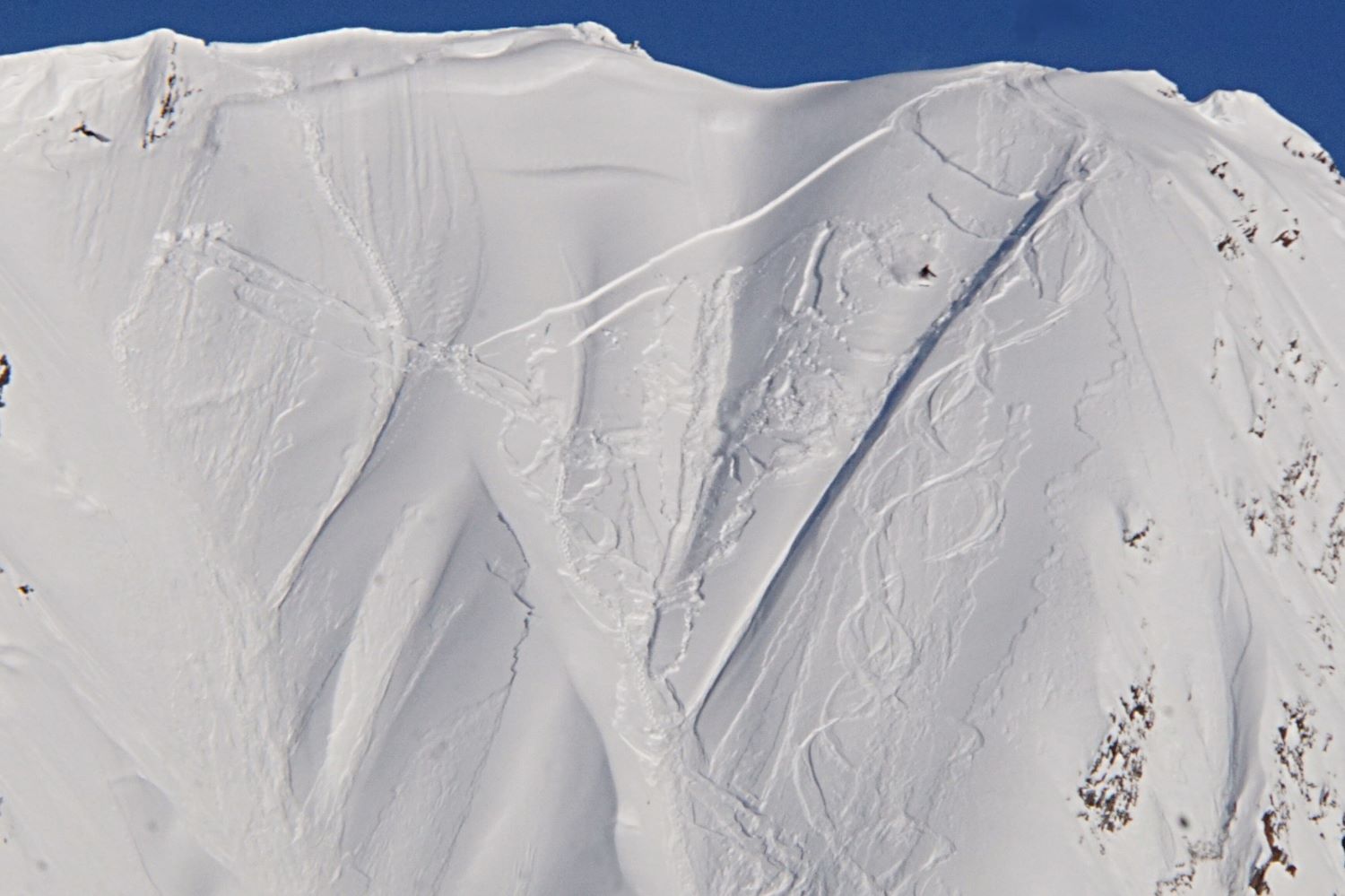
Cornices: We have recently seen large cornices peeling away from ridgelines, opening up large cracks (there are some good photos here). Be sure to give them plenty of space, and minimize the amount of time you spend below them.

Wind-loading from the south on peak 4940′ at the southern end of Turnagain Pass. 1.31.21.

The thin line of buried surface hoar was easy to spot in a pit on Petes North yesterday at 2200′. There wasn’t much new snow on top of it in this area but wind-loaded slopes or areas that received more snow could have sensitive slabs. 1.31.21.


Additional Concern
  • Glide Avalanches
    Glide Avalanches
Glide Avalanches
Glide Avalanches are the release of the entire snow cover as a result of gliding over the ground. Glide avalanches can be composed of wet, moist, or almost entirely dry snow. They typically occur in very specific paths, where the slope is steep enough and the ground surface is relatively smooth. They are often proceeded by full depth cracks (glide cracks), though the time between the appearance of a crack and an avalanche can vary between seconds and months. Glide avalanches are unlikely to be triggered by a person, are nearly impossible to forecast, and thus pose a hazard that is extremely difficult to manage.
More info at Avalanche.org

Glide cracks exist across the forecast area. Remember it is important to limit time spent underneath them. Glide avalanches are totally unpredictable, not triggered by people and are the entire snowpack sliding at the ground. This type of avalanche could be large and unsurvivable if you happened to be in wrong place when one releases. If you see recent glide activity please let us know.

Weather
Mon, February 1st, 2021

Yesterday: Skies were mostly clear with some valley fog along Turnagain Arm and into Girdwood. Temperatures were in the single digits to low teens. Winds were northwesterly 5-15 mph gusting into the 20s. Overnight skies were mostly clear, temperatures dropped to the low single digits or below 0°F in some locations, winds remained northwesterly 5-15 mph gusting into the 20s.

Today: Another day of clear skies and northwest winds 5-15 mph with gust into the 20s. Temperatures will be in the low single digits to below 0°F. Skies remain clear overnight and temperatures will slowly rise. NW winds continue until early Tuesday morning when they shift to the east.

Tomorrow: Skies will be sunny in the morning with increasing clouds in the afternoon. Temperatures will be in the mid teens and winds will be light and easterly.

PRECIPITATION 24-hour data (6am – 6am)

Temp Avg (F) Snow (in) Water (in) Snow Depth (in)
Center Ridge (1880′) 7 0 0 124
Summit Lake (1400′) -5 0 0 42
Alyeska Mid (1700′) 7 0 0 106

RIDGETOP 24-hour data (6am – 6am)

Temp Avg (F) Wind Dir Wind Avg (mph) Wind Gust (mph)
Sunburst (3812′) 6 WNW 9 23
Seattle Ridge (2400′) 6 NW 3 10
Observations
Recent Observations for Turnagain Pass
Date Region Location
04/16/24 Turnagain Observation: Cornbiscuit
04/15/24 Turnagain Observation: Taylor Pass
04/15/24 Turnagain Observation: Seward Highway – Tern Lake to Portage
04/14/24 Turnagain Observation: Sunburst
04/14/24 Turnagain Observation: Turnagain Pass Snomo
04/13/24 Turnagain Observation: Spokane Creek
04/11/24 Turnagain Observation: Tincan
04/10/24 Turnagain Avalanche: Seattle Ridge
04/10/24 Turnagain Observation: Cornbiscuit South Face
04/10/24 Turnagain Avalanche: Tincan
Riding Areas

The riding areas page has moved. Please click here & update your bookmarks.


Subscribe to Turnagain Pass
Avalanche Forecast by Email

This is a general backcountry avalanche advisory issued for Turnagain Arm with Turnagain Pass as the core advisory area. This advisory does not apply to highways, railroads or operating ski areas.