Turnagain Pass RSS

Archives
ARCHIVED - Forecasts expire after 24 hours.
Issued
Mon, January 23rd, 2023 - 7:00AM
Expires
Tue, January 24th, 2023 - 7:00AM
Forecaster
Andrew Schauer
Avalanche risk The Bottom Line

The avalanche danger is CONSIDERABLE above 1000′. It is likely a person can trigger an avalanche 2′ deep on a weak layer of buried surface hoar. There have been human-triggered avalanches on this layer for 8 days in a row, and conditions will remain dangerous despite the relatively quiet weather expected today. It is also possible to trigger a very large avalanche 4-8′ deep on a layer of weak snow near a crust that formed back around Thanksgiving. Dangerous conditions like this require cautious route finding, which means avoiding spending any time on or below steep slopes.

The danger is MODERATE below 1000′, where the main concerns are wet loose avalanches and debris from larger avalanches in the upper elevations running into low-elevation runout zones.

Mon, January 23rd, 2023
Alpine
Above 2,500'
3 - Considerable
Avalanche risk
Treeline
1,000'-2,500'
3 - Considerable
Avalanche risk
Below Treeline
Below 1,000'
2 - Moderate
Avalanche risk
0 - No Rating
1 - Low
2 - Moderate
3 - Considerable
4 - High
5 - Extreme
Avalanche risk Avalanche risk Avalanche risk Avalanche risk Avalanche risk
Travel Advice Generally safe avalanche conditions. Watch for unstable snow on isolated terrain features. Heightened avalanche conditions on specific terrain features. Evaluate snow and terrain carefully; identify features of concern. Dangerous avalanche conditions. Careful snowpack evaluation, cautious route-finding, and conservative decision-making essential. Very dangerous avalanche conditions. Travel in avalanche terrain not recommended. Extraordinarily dangerous avalanche conditions. Avoid all avalanche terrain.
Likelihood of Avalanches Natural and human-triggered avalanches unlikely. Natural avalanches unlikely; human-triggered avalanches possible. Natural avalanches possible; human-triggered avalanches likely. Natural avalanches likely; human-triggered avalanches very likely. Natural and human-triggered avalanches certain.
Avalanche Size and Distribution Small avalanches in isolated areas or extreme terrain. Small avalanches in specific areas; or large avalanches in isolated areas. Small avalanches in many areas; or large avalanches in specific areas; or very large avalanches in isolated areas. Large avalanches in many areas; or very large avalanches in specific areas. Very large avalanches in many areas.
Recent Avalanches

Tincan South Side: We remotely triggered an avalanche near the Snake Pit on the south side of Tincan yesterday. We were digging pits on a low-angle bench when the avalanche released about 50′ below us where the slope rolled over into steeper terrain. The avalanche was about 2′ deep and 75′ wide, running only 150′ before piling debris up on a flat bench. Nobody was on or below the slope that failed. More details here.

Lynx Creek: We received details yesterday of a snowmachine-triggered avalanche in the Lynx Creek drainage on Saturday. The rider noticed the slope cracking around him and was able to ride off the slab without getting buried. The avalanche was 300′ wide and 2′ deep, likely failing on the 1/10 buried surface hoar layer that has been so reactive for the past week. It is worth mentioning that the group had put multiple sets of tracks on the same slope before the last rider triggered the avalanche. Thanks to the rider for sharing the information from the avalanche. There are more details in this observation.

Photo from the crown of the avalanche we triggered on Tincan yesterday.

Avalanche Problem 1
  • Persistent Slabs
    Persistent Slabs
  • Aspect/Elevation
  • Certain
    Very Likely
    Likely
    Possible
    Unlikely
    Likelihood
  • Historic (D4-5)
    Very Large (D3)
    Large (D2)
    Small (D1)
    Size
Persistent Slabs
Persistent Slab avalanches are the release of a cohesive layer of snow (a slab) in the middle to upper snowpack, when the bond to an underlying persistent weak layer breaks. Persistent layers include: surface hoar, depth hoar, near-surface facets, or faceted snow. Persistent weak layers can continue to produce avalanches for days, weeks or even months, making them especially dangerous and tricky. As additional snow and wind events build a thicker slab on top of the persistent weak layer, this avalanche problem may develop into a Deep Persistent Slab.

Aspect/Elevation of the Avalanche Problem
Specialists develop a graphic representation of the potential distribution of a particular avalanche problem across the topography. This aspect/elevation rose is used to indicate where the particular avalanche problem is thought to exist on all elevation aspects. Areas where the avalanche problem is thought to exist are colored grey, and it is less likely to be encountered in areas colored white.

Likelihood of Avalanches
Terms such as "unlikely", "likely", and "certain" are used to define the scale, with the chance of triggering or observing avalanches increasing as we move up the scale. For our purposes, "Unlikely" means that few avalanches could be triggered in avalanche terrain and natural avalanches are not expected. "Certain" means that humans will be able to trigger avalanches on many slopes, and natural avalanches are expected.

Size of Avalanches
Avalanche size is defined by the largest potential avalanche, or expected range of sizes related to the problem in question. Assigned size is a qualitative estimate based on the destructive classification system and requires specialists to estimate the harm avalanches may cause to hypothetical objects located in the avalanche track (AAA 2016, CAA 2014). Under this schema, "Small" avalanches are not large enough to bury humans and are relatively harmless unless they carry people over cliffs or through trees or rocks. Moving up the scale, avalanches become "Large" enough to bury, injure, or kill people. "Very Large" avalanches may bury or destroy vehicles or houses, and "Historic" avalanches are massive events capable of altering the landscape.

Signal Word Size (D scale) Simple Descriptor
Small 1 Unlikely to bury a person
Large 2 Can bury a person
Very Large 3 Can destroy a house
Historic 4 & 5 Can destroy part or all of a village
More info at Avalanche.org

This layer of buried surface hoar is proving to be quite the persistent problem. There have been natural and human-triggered avalanches on this layer for 8 days in a row now, and it will remain reactive today. With another 0.5-.75″ snow water equivalent (SWE) and strong winds in the past 24 hours, the snowpack continues to see more stress added to this weak layer. Although winds and precipitation are expected to back off for most of the day today, dangerous conditions continue to exist.

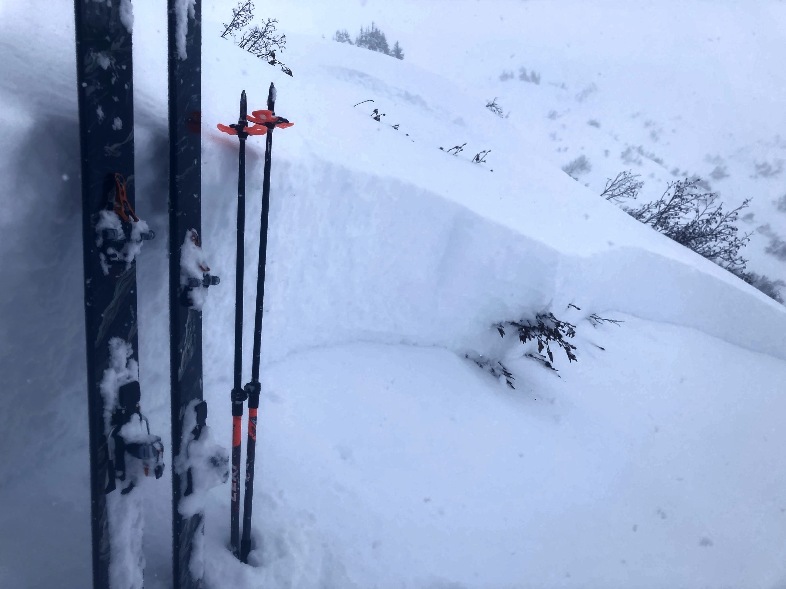
As the layer gets buried deeper, it is slowly becoming more stubborn to trigger. However, with this impressive string of human-triggered avalanches, there is no question that it is still reactive throughout our advisory area. Over the past week we’ve seen activity in almost every part of Turnagain Pass– including Seattle Ridge, Eddie’s, Tincan, Sunburst, Magnum, Cornbiscuit, Pete’s North, and Lynx Creek. Now that the layer is around 2′ deep or deeper, it is becoming harder to detect with common travel tests like hand pits. It is also giving fewer warning signs like shooting cracks or collapsing. Case in point- I was unable to find the layer with hand pits along the skin track yesterday in the Tincan trees, and had been stomping around on the top of a convex roll without any results just minutes before we triggered a large avalanche remotely on the same terrain feature.

The snowpack continues to show its potential for making avalanches, and with continued snow and wind the avalanches are only getting bigger. The only way to manage a dangerous setup like this is by avoiding traveling on or below steep terrain.

Wind Slabs: Winds are backing off slightly this morning, but will be picking up again this afternoon. Pay attention to active wind loading later in the day, and be aware of an increased likelihood of natural and human-triggered avalanches on wind loaded slopes as the wind returns.

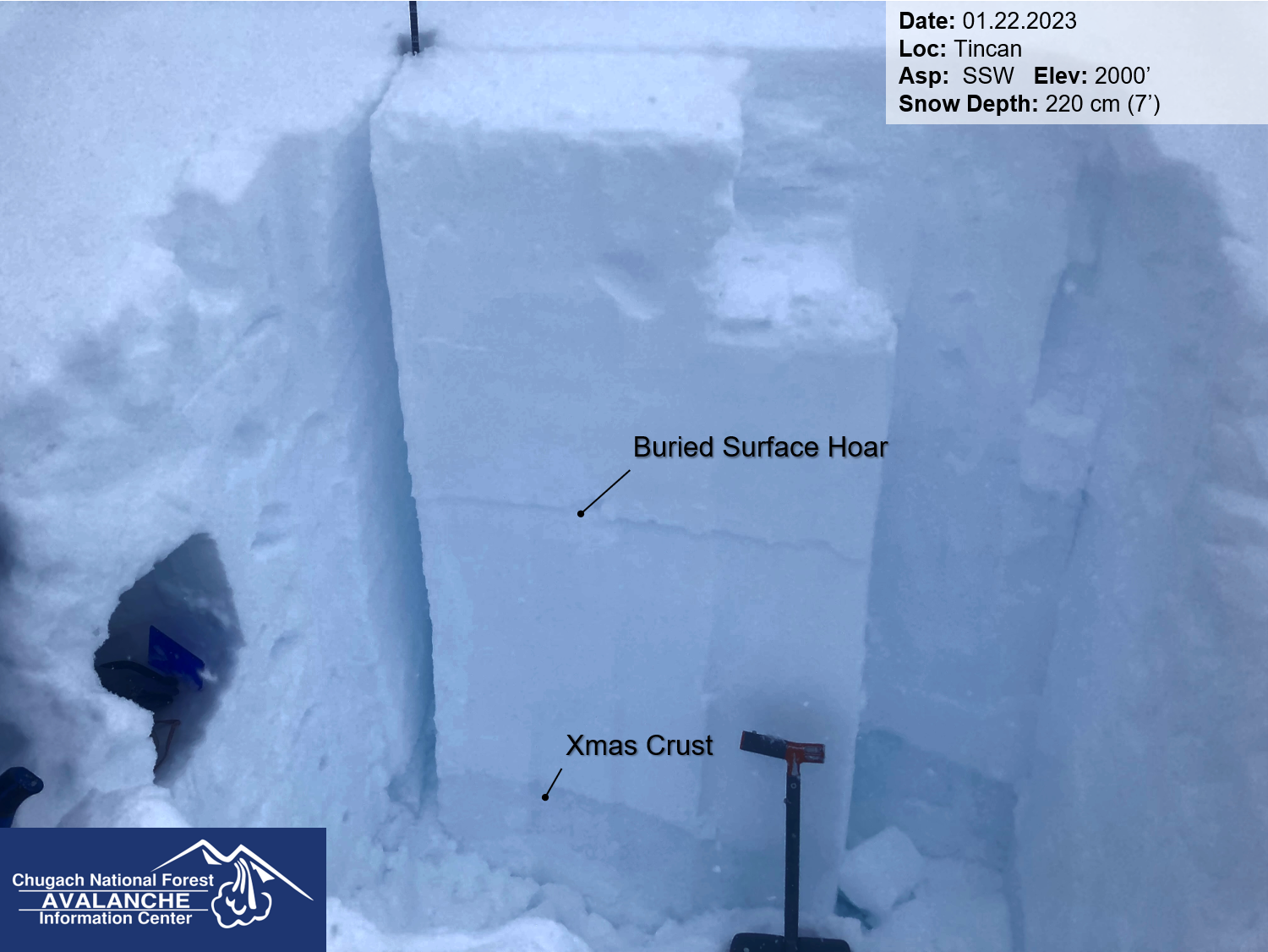
The1/10 buried surface hoar was still reactive in this pit (ECTP 25). The test result was less important than the fact that we triggered a big avalanche just below the pit. 01.22.2023

Avalanche Problem 2
  • Deep Persistent Slabs
    Deep Persistent Slabs
  • Aspect/Elevation
  • Certain
    Very Likely
    Likely
    Possible
    Unlikely
    Likelihood
  • Historic (D4-5)
    Very Large (D3)
    Large (D2)
    Small (D1)
    Size
Deep Persistent Slabs
Deep Persistent Slab avalanches are the release of a thick cohesive layer of hard snow (a slab), when the bond breaks between the slab and an underlying persistent weak layer deep in the snowpack. The most common persistent weak layers involved in deep, persistent slabs are depth hoar or facets surrounding a deeply buried crust. Deep Persistent Slabs are typically hard to trigger, are very destructive and dangerous due to the large mass of snow involved, and can persist for months once developed. They are often triggered from areas where the snow is shallow and weak, and are particularly difficult to forecast for and manage.

Aspect/Elevation of the Avalanche Problem
Specialists develop a graphic representation of the potential distribution of a particular avalanche problem across the topography. This aspect/elevation rose is used to indicate where the particular avalanche problem is thought to exist on all elevation aspects. Areas where the avalanche problem is thought to exist are colored grey, and it is less likely to be encountered in areas colored white.

Likelihood of Avalanches
Terms such as "unlikely", "likely", and "certain" are used to define the scale, with the chance of triggering or observing avalanches increasing as we move up the scale. For our purposes, "Unlikely" means that few avalanches could be triggered in avalanche terrain and natural avalanches are not expected. "Certain" means that humans will be able to trigger avalanches on many slopes, and natural avalanches are expected.

Size of Avalanches
Avalanche size is defined by the largest potential avalanche, or expected range of sizes related to the problem in question. Assigned size is a qualitative estimate based on the destructive classification system and requires specialists to estimate the harm avalanches may cause to hypothetical objects located in the avalanche track (AAA 2016, CAA 2014). Under this schema, "Small" avalanches are not large enough to bury humans and are relatively harmless unless they carry people over cliffs or through trees or rocks. Moving up the scale, avalanches become "Large" enough to bury, injure, or kill people. "Very Large" avalanches may bury or destroy vehicles or houses, and "Historic" avalanches are massive events capable of altering the landscape.

Signal Word Size (D scale) Simple Descriptor
Small 1 Unlikely to bury a person
Large 2 Can bury a person
Very Large 3 Can destroy a house
Historic 4 & 5 Can destroy part or all of a village
More info at Avalanche.org

In addition to the buried surface hoar layer mentioned above, we are also still concerned with the Thanksgiving crust/facet layer– now buried 4-8′ deep on average. At this point, the layer is so deep that a person would need to find just the right (wrong?) spot to trigger it. Deep slab problems are tricky, since they are so stubborn but if you do find a thin spot where the weight of a person can collapse the weak layer, the avalanche could take down the entire mountainside. Stability tests tell us very little about the layer, and it will almost never give warning signs like shooting cracks or collapsing. They are also notorious for releasing after there are multiple sets of tracks on the slope.

As time goes on it is becoming less likely that a person will trigger an avalanche on this layer, but it is still on our radar for now. Given the widespread persistent slab problem mentioned in problem 1 above, this monster is just one more reason to avoid traveling on or below steep terrain for now.

Click here to view the video below if it doesn’t load in your browser.

Weather
Mon, January 23rd, 2023

Yesterday: Sustained snow showers brought 4-8″ new snow equaling 0.4-0.75″ snow water equivalent (SWE). Easterly winds were blowing 20-35 mph with gusts of 45-55 mph, backing down to 5-15 mph this morning. High temperatures were in the mid 20’s at upper elevations and mid 30’s at lower elevations. The rain line reached around 800-1000′.

Today: Winds are backing off this morning, currently blowing 5-15 mph out of the southeast. They are expected to pick up to 15-20 mph and shift more southerly later today through tonight. Most of today’s precipitation will miss the advisory area, with only a trace to 2″ of snow above 1500′ equaling up to 0.15″ SWE. Skies will be cloudy with high temperatures in the upper 20’s to low 30’s F and slightly increasing through the day into tonight.

Tomorrow: Stronger southeasterly winds will continue for most of the day tomorrow, with sustained speeds around 15-25 mph and gusts of 20-35 mph. We should see light precipitation during the day bringing another trace to 2″ snow. Precipitation should pick up a bit tomorrow night, with 3-5″ snow possible at higher elevations, but the rain line is going to start moving up to close to 2000′. Skies should be mostly cloudy with temperatures hovering in the upper 20’s at higher elevations and mid 30’s at lower elevations.

PRECIPITATION 24-hour data (6am – 6am)

Temp Avg (F) Snow (in) Water (in) Snow Depth (in)
Center Ridge (1880′) 31 4 0.4 71
Summit Lake (1400′) 31 2 0.2 34
Alyeska Mid (1700′) 31 5 0.4 70
Bear Valley – Portage (132′) 37 rain 0.8

RIDGETOP 24-hour data (6am – 6am)

Temp Avg (F) Wind Dir Wind Avg (mph) Wind Gust (mph)
Sunburst (3812′) 22 ENE 19 54
Seattle Ridge (2400′) 26 SE 10 29
Observations
Recent Observations for Turnagain Pass
Date Region Location
04/21/24 Turnagain Observation: Bertha Creek
04/20/24 Turnagain Avalanche: Spokane Creek
04/16/24 Turnagain Observation: Cornbiscuit
04/15/24 Turnagain Observation: Taylor Pass
04/15/24 Turnagain Observation: Seward Highway – Tern Lake to Portage
04/14/24 Turnagain Observation: Sunburst
04/14/24 Turnagain Observation: Turnagain Pass Snomo
04/13/24 Turnagain Observation: Spokane Creek
04/11/24 Turnagain Observation: Tincan
04/10/24 Turnagain Avalanche: Seattle Ridge
Riding Areas

The riding areas page has moved. Please click here & update your bookmarks.


Subscribe to Turnagain Pass
Avalanche Forecast by Email

This is a general backcountry avalanche advisory issued for Turnagain Arm with Turnagain Pass as the core advisory area. This advisory does not apply to highways, railroads or operating ski areas.