Turnagain Pass RSS

Archives
ARCHIVED - Forecasts expire after 24 hours.
Issued
Mon, March 18th, 2019 - 7:00AM
Expires
Tue, March 19th, 2019 - 7:00AM
Forecaster
Wendy Wagner
Avalanche risk The Bottom Line

The avalanche danger remains  HIGH in the backcountry. Very large avalanches occurred naturally yesterday and are expected to keep releasing today. Ten days of stormy weather has been loading slopes with 8 to 15 feet of snow, which is peeling off the mountains. These slides are big and have been sending debris far into runout zones and through flat areas.  Travel in avalanche terrain is not recommended. Give runout zones an extra wide berth as debris may run much further than expected.  

PORTAGE VALLEY:   Large natural avalanches may send debris all the way to valley floors today, despite a break in weather. Travel in runout zones from avalanches that may occur above is NOT recommended. This includes venturing along and past the Byron Glacier Trail.

SUMMIT LAKE (& INTERIOR EASTERN KENAI MTS):    Large to very large human triggered avalanches remain very likely. Between 2-3 feet of snow has fallen onto a very weak snowpack and avalanche are releasing in old buried weak layers.  Travel in avalanche terrain is not recommended in these zones.

SEWARD/LOST LAKE:    Large and dangerous natural avalanches  have been observed in this area. Continued rain, wind, snow and even sunshine and warm temperatures is keeping the avalanche danger elevated. Travel in avalanche terrain is not recommended.  

Special Announcements
  • There will be intermittent traffic delays today  on the Seward Highway for avalanche hazard reduction work. Near mileposts 23 to 20, on the Seward Highway, between Crown Point and Snow River.  Motorists should expect delays of up to 45 minutes between 12:00 noon and 2:00 PM.  Updates will be posted on the 511 system.    http://511.alaska.gov/
  • Turnagain Pass 20 years later:  On  Saturday, March 23rd from 12-2pm  swing by the Turnagain Pass moto lot and meet the CNFAIC avalanche forecasters, bring and test your avalanche rescue gear and learn about the history of Turnagain Pass and the CNFAIC. We’ll even have a few beacons buried so you can test your skills before heading into the hills!
Mon, March 18th, 2019
Alpine
Above 2,500'
4 - High
Avalanche risk
Treeline
1,000'-2,500'
4 - High
Avalanche risk
Below Treeline
Below 1,000'
4 - High
Avalanche risk
0 - No Rating
1 - Low
2 - Moderate
3 - Considerable
4 - High
5 - Extreme
Avalanche risk Avalanche risk Avalanche risk Avalanche risk Avalanche risk
Travel Advice Generally safe avalanche conditions. Watch for unstable snow on isolated terrain features. Heightened avalanche conditions on specific terrain features. Evaluate snow and terrain carefully; identify features of concern. Dangerous avalanche conditions. Careful snowpack evaluation, cautious route-finding, and conservative decision-making essential. Very dangerous avalanche conditions. Travel in avalanche terrain not recommended. Extraordinarily dangerous avalanche conditions. Avoid all avalanche terrain.
Likelihood of Avalanches Natural and human-triggered avalanches unlikely. Natural avalanches unlikely; human-triggered avalanches possible. Natural avalanches possible; human-triggered avalanches likely. Natural avalanches likely; human-triggered avalanches very likely. Natural and human-triggered avalanches certain.
Avalanche Size and Distribution Small avalanches in isolated areas or extreme terrain. Small avalanches in specific areas; or large avalanches in isolated areas. Small avalanches in many areas; or large avalanches in specific areas; or very large avalanches in isolated areas. Large avalanches in many areas; or very large avalanches in specific areas. Very large avalanches in many areas.
Avalanche Problem 1
  • Storm Slabs
    Storm Slabs
  • Certain
    Very Likely
    Likely
    Possible
    Unlikely
    Likelihood
  • Historic (D4-5)
    Very Large (D3)
    Large (D2)
    Small (D1)
    Size
Storm Slabs
Storm Slab avalanches are the release of a cohesive layer (a slab) of new snow that breaks within new snow or on the old snow surface. Storm-slabs typically last between a few hours and few days (following snowfall). Storm-slabs that form over a persistent weak layer (surface hoar, depth hoar, or near-surface facets) may be termed Persistent Slabs or may develop into Persistent Slabs.

Likelihood of Avalanches
Terms such as "unlikely", "likely", and "certain" are used to define the scale, with the chance of triggering or observing avalanches increasing as we move up the scale. For our purposes, "Unlikely" means that few avalanches could be triggered in avalanche terrain and natural avalanches are not expected. "Certain" means that humans will be able to trigger avalanches on many slopes, and natural avalanches are expected.

Size of Avalanches
Avalanche size is defined by the largest potential avalanche, or expected range of sizes related to the problem in question. Assigned size is a qualitative estimate based on the destructive classification system and requires specialists to estimate the harm avalanches may cause to hypothetical objects located in the avalanche track (AAA 2016, CAA 2014). Under this schema, "Small" avalanches are not large enough to bury humans and are relatively harmless unless they carry people over cliffs or through trees or rocks. Moving up the scale, avalanches become "Large" enough to bury, injure, or kill people. "Very Large" avalanches may bury or destroy vehicles or houses, and "Historic" avalanches are massive events capable of altering the landscape.

Signal Word Size (D scale) Simple Descriptor
Small 1 Unlikely to bury a person
Large 2 Can bury a person
Very Large 3 Can destroy a house
Historic 4 & 5 Can destroy part or all of a village
More info at Avalanche.org

Large to very large natural avalanches are occurring across the mountains while the parade of wet March storms roll through. Yesterday seemed to be a tipping point for a natural avalanche cycle. Evidence of many avalanches were seen during a short window of ‘marginal’ visibility. Magnum’s West face slid through low angle terrain piling debris across the entire base of the face all the way to the power line, this is a notable situation as low angle slopes under larger terrain can be unsafe right now. Crowns and debris were also seen in many paths in the 20-mile drainage, Portage and Placer Valleys, Seattle Ridge, Eddies, Sunburst, Pete’s South and Johnson Pass.

Too much snow, too fast with warming temperatures, along with rain on snow, is all contributing to this avalanche problem. After the 2 week dry spell, ending March 7th, the mountains around Portage and Girdwood have seen 10-15 feet of snow since March 8th at the high elevations, between 6-8 feet around Turnagain Pass and 2-4 feet in the interior Kenai. Avalanche paths that have not slid could release large amounts of debris as we saw yesterday. If you are planning to head into the backcountry, keep it safe and give runout zones a VERY wide margin. The Magnum avalanche is a good example of how someone could accidentally be in the wrong place at the wrong time. It’s not the time to be anywhere near or under slopes over 30 degrees. 

Although the peak of the storm is moving out, increased warming today, whether it be additional rain on snow or sunshine that pokes through the clouds, will keep natural avalanches likely. Wet slab and wet loose avalanches are expected below 2,500′ with the potential for dry snow avalanches above. Check out the graphic below for how warm temperatures are expected this afternoon.


Magnum’s West Face is littered with debris. Debris is covering the low angel terrain all the way to the powerline. This path does not often run this far. 


Natural slab avalanche on the SW face of Sunburst, a very popular ski run. 


Natural slab avalanches on the SW facing of Pete’s South face. The looker’s right side of this path can, and possibly did, threaten the Johnson Pass trail.


Very warm temperatures are on tap today.


Weather
Mon, March 18th, 2019

Yesterday:   Mostly obscured skies, strong winds, rain and snow were over the region. Between 0.5 – 1.5″ of rain fell over the past 24-hours up to 2,000′ at times, favoring Girdwood and Portage (equating to 5 to 15″ or so of snow at the higher elevations). Ridgetop easterly winds again blew 40-60mph on average and gusted close to 100mph at the Sunburst weather station. Temperatures reached 32F at 2,500′ and the low 40’sF at sea level before dropping only a few degrees overnight.  

            Storm Totals (Mar 13, 6am – Mar 18, 6am):

    • Turnagain Pass 1800′:   ~21″ wet snow, 5.8″ SWE   (5-7′ of settled moist storm snow  at 2,500′)
    • Girdwood-Alyeska Midway 1700′: ~25″ wet snow, 5.8″ SWE
    • Summit Lake 1400′: ~15″ wet snow, 2.0″ SWE
    • Portage Valley 95′: ~8-11+ ft snow in upper elevations —  11″ rain at lower elevations

Today:   Partly cloudy skies with patches of light rain, snow and wind will be over the area as last night’s system filters north. We may see some sun poke through in areas as well. Around .2 to .3″ of rain is expected below 2,000′ with 2-3″ of wet snow above this. Ridgetop easterly winds have decreased this morning are expected to remain in the 20-30mph range. Temperatures could reach 32F at 3,000′ today and should be in the mid 40’sF at sea level.  

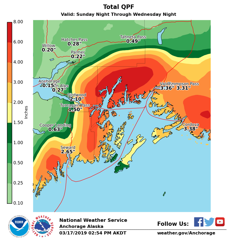
Tomorrow:    We could see a brief break is weather and clearing skies Tuesday morning before another series of warm storms moves through Tuesday evening into the weekend. Rising temperatures are expected to bring rain up to 3,000′ in places. Check out the great graphics from our friends at the National Weather Service below:


PRECIPITATION 24-hour data (6am – 6am)

  Temp Avg (F) Snow (in) Water (in) Snow Depth (in)
Center Ridge (1880′) 35   0 0.9   94  
Summit Lake (1400′) 36   0   0.1 – 0.5   32  
Alyeska Mid (1700′) 34   0   1. 82  

RIDGETOP 24-hour data (6am – 6am)

  Temp Avg (F) Wind Dir Wind Avg (mph) Wind Gust (mph)
Sunburst (3812′) 26    NE 41   97  
Seattle Ridge (2400′) 31   *N/A   *N/A     *N/A    
Observations
Recent Observations for Turnagain Pass
Date Region Location
10/27/24 Turnagain Observation: Tincan
10/21/24 Turnagain Observation: Turnagain Pass Road Observation
10/19/24 Turnagain Observation: Tincan – Below Todds Run
10/18/24 Turnagain Observation: Taylor Pass
10/15/24 Turnagain Observation: Tincan Common
10/14/24 Turnagain Avalanche: Tincan
05/13/24 Turnagain Observation: Eddie’s, Sunburst, Seattle, Cornbiscuit, Pete’s South
05/13/24 Turnagain Observation: Turnagain Pass non-motorized side
05/12/24 Turnagain Observation: Warm up Bowl
05/07/24 Turnagain Observation: Turnagain Pass Wet Slabs
Riding Areas

The riding areas page has moved. Please click here & update your bookmarks.


Subscribe to Turnagain Pass
Avalanche Forecast by Email

This is a general backcountry avalanche advisory issued for Turnagain Arm with Turnagain Pass as the core advisory area. This advisory does not apply to highways, railroads or operating ski areas.