Turnagain Pass RSS

Archives
ARCHIVED - Forecasts expire after 24 hours.
Issued
Mon, January 7th, 2019 - 7:00AM
Expires
Tue, January 8th, 2019 - 7:00AM
Forecaster
Aleph Johnston-Bloom
Avalanche risk The Bottom Line

The avalanche danger remains  MODERATE  above 1,000′. Triggering a slab avalanche 2-3′ thick is still possible. Wind affected terrain in the Alpine is the most suspect.  Glide cracks are opening and have been avalanching during this cold snap. This is the time to avoid being under cracks. As always, give cornices a wide berth and watch your sluff.  

SUMMIT LAKE / JOHNSON PASS / LYNX DRAINAGE:  South of Turnagain Pass, keep in mind multiple buried weak layers exist in the middle and base of the snowpack. More potential for triggering a slab avalanche exists in this zone.  

Special Announcements

There have been three avalanche fatalities in the US this season. Two occurred on Saturday, January 5th. Our thoughts go out to the family, friends and all impacted by these accidents.  

Mon, January 7th, 2019
Alpine
Above 2,500'
2 - Moderate
Avalanche risk
Treeline
1,000'-2,500'
2 - Moderate
Avalanche risk
Below Treeline
Below 1,000'
1 - Low
Avalanche risk
0 - No Rating
1 - Low
2 - Moderate
3 - Considerable
4 - High
5 - Extreme
Avalanche risk Avalanche risk Avalanche risk Avalanche risk Avalanche risk
Travel Advice Generally safe avalanche conditions. Watch for unstable snow on isolated terrain features. Heightened avalanche conditions on specific terrain features. Evaluate snow and terrain carefully; identify features of concern. Dangerous avalanche conditions. Careful snowpack evaluation, cautious route-finding, and conservative decision-making essential. Very dangerous avalanche conditions. Travel in avalanche terrain not recommended. Extraordinarily dangerous avalanche conditions. Avoid all avalanche terrain.
Likelihood of Avalanches Natural and human-triggered avalanches unlikely. Natural avalanches unlikely; human-triggered avalanches possible. Natural avalanches possible; human-triggered avalanches likely. Natural avalanches likely; human-triggered avalanches very likely. Natural and human-triggered avalanches certain.
Avalanche Size and Distribution Small avalanches in isolated areas or extreme terrain. Small avalanches in specific areas; or large avalanches in isolated areas. Small avalanches in many areas; or large avalanches in specific areas; or very large avalanches in isolated areas. Large avalanches in many areas; or very large avalanches in specific areas. Very large avalanches in many areas.
Avalanche Problem 1
  • Persistent Slabs
    Persistent Slabs
  • Certain
    Very Likely
    Likely
    Possible
    Unlikely
    Likelihood
  • Historic (D4-5)
    Very Large (D3)
    Large (D2)
    Small (D1)
    Size
Persistent Slabs
Persistent Slab avalanches are the release of a cohesive layer of snow (a slab) in the middle to upper snowpack, when the bond to an underlying persistent weak layer breaks. Persistent layers include: surface hoar, depth hoar, near-surface facets, or faceted snow. Persistent weak layers can continue to produce avalanches for days, weeks or even months, making them especially dangerous and tricky. As additional snow and wind events build a thicker slab on top of the persistent weak layer, this avalanche problem may develop into a Deep Persistent Slab.

Likelihood of Avalanches
Terms such as "unlikely", "likely", and "certain" are used to define the scale, with the chance of triggering or observing avalanches increasing as we move up the scale. For our purposes, "Unlikely" means that few avalanches could be triggered in avalanche terrain and natural avalanches are not expected. "Certain" means that humans will be able to trigger avalanches on many slopes, and natural avalanches are expected.

Size of Avalanches
Avalanche size is defined by the largest potential avalanche, or expected range of sizes related to the problem in question. Assigned size is a qualitative estimate based on the destructive classification system and requires specialists to estimate the harm avalanches may cause to hypothetical objects located in the avalanche track (AAA 2016, CAA 2014). Under this schema, "Small" avalanches are not large enough to bury humans and are relatively harmless unless they carry people over cliffs or through trees or rocks. Moving up the scale, avalanches become "Large" enough to bury, injure, or kill people. "Very Large" avalanches may bury or destroy vehicles or houses, and "Historic" avalanches are massive events capable of altering the landscape.

Signal Word Size (D scale) Simple Descriptor
Small 1 Unlikely to bury a person
Large 2 Can bury a person
Very Large 3 Can destroy a house
Historic 4 & 5 Can destroy part or all of a village
More info at Avalanche.org

A buried layer of surface hoar may sit 2-3′ below the surface of the snow. Zones that saw prior wind effect (especially in the Alpine) are most concerning where the buried surface hoar is potentially sandwiched between layers of harder snow. This was the set-up in the one known human triggered avalanche on this layer that occurred on Wednesday, Jan. 2nd on Seattle Ridge. As time passes, high pressure and cold temperatures continue and more information is gathered, we are finding that being able to trigger a slab avalanche breaking 2-3′ deep is becoming less and less likely. Most snowpack tests and pits have shown the layer to be either generally unreactive or not present. The spooky part is that it has been found in a few pockets with the hard snow above and below and the potential to initiate an avalanche. Signs of instability will likely not be present. 

When there is a buried surface hoar in the snowpack it is always important to consider the consequences if part or all of the slope does release. Is there a terrain trap below? Remember to use safe travel protocols: watch your partners, expose one person at a time and have an escape route planned. 

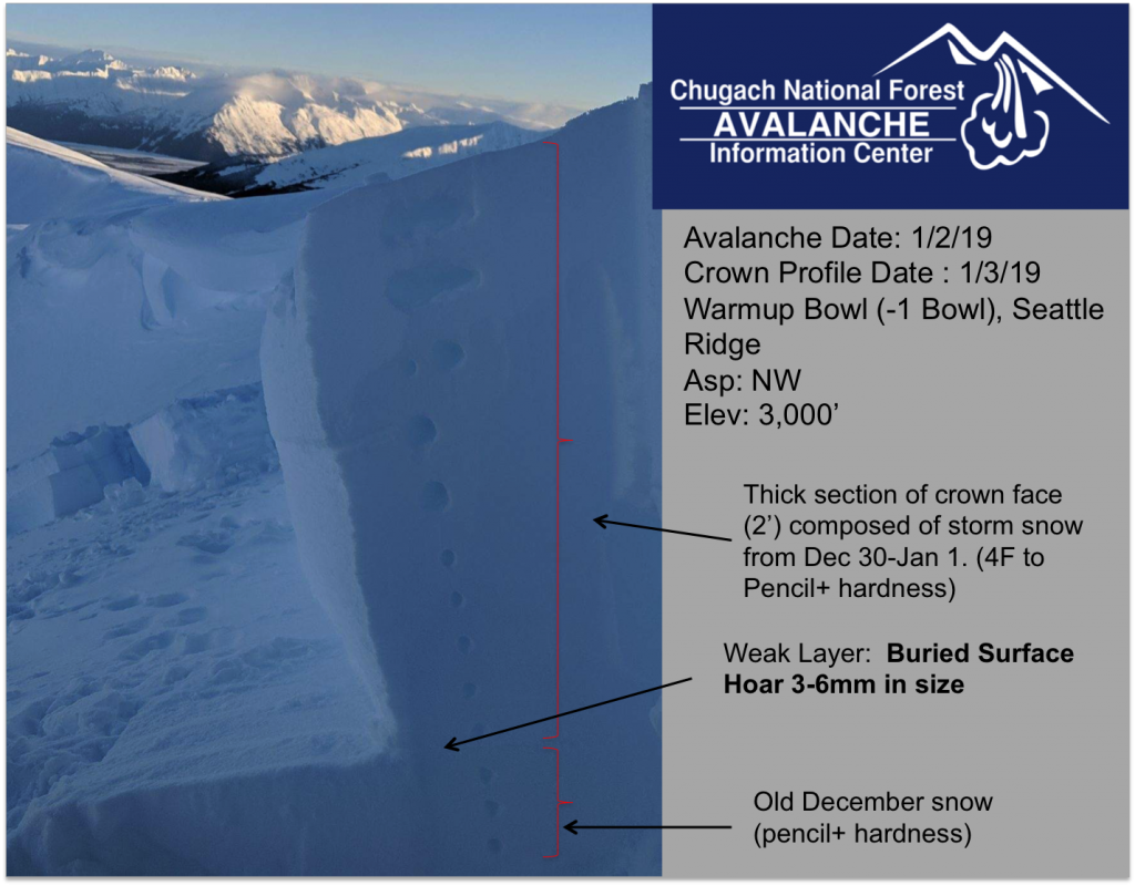
Buried surface hoar sandwiched between hard layers of snow. 1-2-19.  

South of Turnagain – Lynx Creek/Johnson Pass/Summit Lake zone:  A poor snowpack structure exists in these areas. The buried surface hoar mentioned above exists as well as facet/crust combinations in the bottom of the snowpack. The New Year’s storm overloaded a variety of these weak layers as can be seen in photos from the avalanche activity throughout Summit LakeIf you’re headed this way, the snowpack becomes more complex – evaluate terrain exposure and the snowpack as you travel. 

Avalanche Problem 2
  • Glide Avalanches
    Glide Avalanches
  • Certain
    Very Likely
    Likely
    Possible
    Unlikely
    Likelihood
  • Historic (D4-5)
    Very Large (D3)
    Large (D2)
    Small (D1)
    Size
Glide Avalanches
Glide Avalanches are the release of the entire snow cover as a result of gliding over the ground. Glide avalanches can be composed of wet, moist, or almost entirely dry snow. They typically occur in very specific paths, where the slope is steep enough and the ground surface is relatively smooth. They are often proceeded by full depth cracks (glide cracks), though the time between the appearance of a crack and an avalanche can vary between seconds and months. Glide avalanches are unlikely to be triggered by a person, are nearly impossible to forecast, and thus pose a hazard that is extremely difficult to manage.

Likelihood of Avalanches
Terms such as "unlikely", "likely", and "certain" are used to define the scale, with the chance of triggering or observing avalanches increasing as we move up the scale. For our purposes, "Unlikely" means that few avalanches could be triggered in avalanche terrain and natural avalanches are not expected. "Certain" means that humans will be able to trigger avalanches on many slopes, and natural avalanches are expected.

Size of Avalanches
Avalanche size is defined by the largest potential avalanche, or expected range of sizes related to the problem in question. Assigned size is a qualitative estimate based on the destructive classification system and requires specialists to estimate the harm avalanches may cause to hypothetical objects located in the avalanche track (AAA 2016, CAA 2014). Under this schema, "Small" avalanches are not large enough to bury humans and are relatively harmless unless they carry people over cliffs or through trees or rocks. Moving up the scale, avalanches become "Large" enough to bury, injure, or kill people. "Very Large" avalanches may bury or destroy vehicles or houses, and "Historic" avalanches are massive events capable of altering the landscape.

Signal Word Size (D scale) Simple Descriptor
Small 1 Unlikely to bury a person
Large 2 Can bury a person
Very Large 3 Can destroy a house
Historic 4 & 5 Can destroy part or all of a village
More info at Avalanche.org

Glides cracks have been observed in all the hot spots on Turnagain: Seattle Ridge, Lipps, Tincan, Eddies, Lynx Creek, Johnson Pass, Sunburst, Corn Biscuit and Magnum. “Gliding” is the whole snowpack is slowly sliding down the mountainsides and can release into an avalanche at anytime. This is a completely unpredictable situation and one where a human does not play a role. Glide cracks have been releasing into large avalanches over the past week. Please don’t be caught in the wrong place at the wrong time and limit/avoid exposure under any crack you see. The most recent glide avalanche we know of was on the south face of Eddies where the glide debris covered fresh ski tracks. Cracks maybe white and look like bergshrunds at first before progressing to the brown frown and the snow sometimes looks like a wrinkled sheet on the slope below. Glide cracks have now been observed in both the Alpine and Treeline elevation bands. 

Glide cracks in the Library, 1-6-19. Photo: Andy Moderow

 Glide cracks in Petersen Creek, 1-6-19. Photo: Alan Abel

Weather
Mon, January 7th, 2019

Yesterday: The pattern of cold temperatures, clear skies and valley fog continued yesterday. Highs were in the low teens to single digits and lows were below zero with a slight inversion.  

Today: Another cold, clear day with valley fog is forecast. Highs will be in the teens at upper elevations and lows will be in the single digits. Winds will be light and southerly. Temperatures will slowly rise with a chance of light precipitation overnight.  

Tomorrow: Partly to mostly cloudy skies and a chance of snow showers with temperatures in the high teens. On Wednesday the pattern goes back to clear, sunny. Warmer temperatures and snow are in the long-term forecast for the weekend.  

*Seattle Ridge weather station was heavily rimed and the anemometer (wind sensor) was destroyed. We are currently working to replace it.  

PRECIPITATION 24-hour data (6am – 6am)

  Temp Avg (F) Snow (in) Water (in) Snow Depth (in)
Center Ridge (1880′)  0   0    0 57  
Summit Lake (1400′) -7   0     0    20    
Alyeska Mid (1700′) 3 0    0 46  

RIDGETOP 24-hour data (6am – 6am)

  Temp Avg (F) Wind Dir Wind Avg (mph) Wind Gust (mph)
Sunburst (3812′) 5   NW   6   17  
Seattle Ridge (2400′)  3     *N/A   *N/A   *N/A
Observations
Recent Observations for Turnagain Pass
Date Region Location
03/27/24 Turnagain Observation: Tincan Trees
03/26/24 Turnagain Observation: Cornbiscuit
03/25/24 Turnagain Observation: Tincan
03/22/24 Turnagain Avalanche: Magnum Northwest Aspect
03/21/24 Turnagain Observation: Sunburst
03/21/24 Turnagain Observation: Tincan Proper North Aspect
03/20/24 Turnagain Avalanche: Seattle Creek Drainage
03/19/24 Turnagain Observation: Tincan CFR
03/18/24 Turnagain Avalanche: Tincan – Eddies – Seattle Ridge
03/18/24 Turnagain Observation: Tincan
Riding Areas

The riding areas page has moved. Please click here & update your bookmarks.


Subscribe to Turnagain Pass
Avalanche Forecast by Email

This is a general backcountry avalanche advisory issued for Turnagain Arm with Turnagain Pass as the core advisory area. This advisory does not apply to highways, railroads or operating ski areas.