Turnagain Pass Avalanche Forecast RSS

Archives
ARCHIVED FORECAST - All forecasts expire after 24 hours from the posting date/time.
Issued
Fri, March 23rd, 2018 - 7:00AM
Expires
Sat, March 24th, 2018 - 7:00AM
Forecaster
Heather Thamm
Avalanche risk The Bottom Line

The avalanche danger is  MODERATE  above 1000′. Triggering a large, destructive slab avalanche 2-4+ feet thick is possible on all aspects and may be remotely triggered. Watch for wind slabs along ridgelines and avoid cornices. Pay attention to afternoon warming. Evaluate snow and terrain carefully.  

Below 1000′ avalanche danger is LOW where a stout surface crust has formed.  

Special Announcements

Heads up in the Eagle River area and North to Hatcher Pass  where strong winds this week have triggered many large and destructive natural avalanches. Check out our observations page HERE for information about avalanche activity over the past week region-wide.  

Thanks to our sponsors!
Fri, March 23rd, 2018
Alpine
Above 2,500'
Moderate (2)
Avalanche risk
Treeline
1,000'-2,500'
Moderate (2)
Avalanche risk
Below Treeline
Below 1,000'
Low (1)
Avalanche risk
Alpine
Above 2,500'
Avalanche risk
Moderate (2)
Treeline
1,000'-2,500'
Avalanche risk
Moderate (2)
Below Treeline
Below 1,000'
Avalanche risk
Low (1)
Danger Scale:
No Rating (0)
Low (1)
Moderate (2)
Considerable (3)
High (4)
Extreme (5)
Avalanche Problem 1
  • Deep Persistent Slabs
    Deep Persistent Slabs
  • Almost Certain
    Very Likely
    Likely
    Possible
    Unlikely
    Likelihood
  • Historic (D4-5)
    Very Large (D3)
    Large (D2)
    Small (D1)
    Size
Deep Persistent Slabs
Deep Persistent Slab avalanches are the release of a thick cohesive layer of hard snow (a slab), when the bond breaks between the slab and an underlying persistent weak layer deep in the snowpack. The most common persistent weak layers involved in deep, persistent slabs are depth hoar or facets surrounding a deeply buried crust. Deep Persistent Slabs are typically hard to trigger, are very destructive and dangerous due to the large mass of snow involved, and can persist for months once developed. They are often triggered from areas where the snow is shallow and weak, and are particularly difficult to forecast for and manage.

Likelihood of Avalanches
Terms such as "unlikely", "likely", and "certain" are used to define the scale, with the chance of triggering or observing avalanches increasing as we move up the scale. For our purposes, "Unlikely" means that few avalanches could be triggered in avalanche terrain and natural avalanches are not expected. "Certain" means that humans will be able to trigger avalanches on many slopes, and natural avalanches are expected.

Size of Avalanches
Avalanche size is defined by the largest potential avalanche, or expected range of sizes related to the problem in question. Assigned size is a qualitative estimate based on the destructive classification system and requires specialists to estimate the harm avalanches may cause to hypothetical objects located in the avalanche track (AAA 2016, CAA 2014). Under this schema, "Small" avalanches are not large enough to bury humans and are relatively harmless unless they carry people over cliffs or through trees or rocks. Moving up the scale, avalanches become "Large" enough to bury, injure, or kill people. "Very Large" avalanches may bury or destroy vehicles or houses, and "Historic" avalanches are massive events capable of altering the landscape.

Signal Word Size (D scale) Simple Descriptor
Small 1 Unlikely to bury a person
Large 2 Can bury a person
Very Large 3 Can destroy a house
Historic 4 & 5 Can destroy part or all of a village
More info at Avalanche.org

Triggering an deep slab avalanche 2-4+ feet thick remains a scary possibility. Strong Northwest winds that ended Thursday morning loaded a variety of aspects and scoured many ridge lines.  Shaded aspects (North to Northeast) may be more loaded with this unusual wind direction. All aspects are suspect due to well preserved and widespread buried surface hoar and facets under a thick, connected slab 2-4+ feet thick. A thin sun crust on solar aspects may soften in the afternoon with the sun and remember daily warming in the mid 30F’s can make it easier to trigger a slab. Our current hard-pack snow conditions are deceiving and may give the appearance of ‘stable snow’. Knowing where in the terrain a large and destructive avalanche could be triggered is a difficult question. It may be the 10th person onto the slope that finds a thin part of the snowpack (a trigger point) or it could be a person triggering a slab remotely on an adjacent slope or below. This was the case on Tuesday in Girdwood when a helicopter remotely triggered an avalanche from 1/4 mile away. There is a lot of uncertainty around this avalanche problem and just how stubborn it will be to trigger now that winds have mellowed out. 

With a deep slab problem it is important to remember no signs of instability may be present before a slope releases.  Thin spots near rocks and along ridgelines are likely trigger points. Take a moment to visualize the consequences if the slope does slide. How far would a very large avalanche run in this terrain? Are there terrain traps below?   

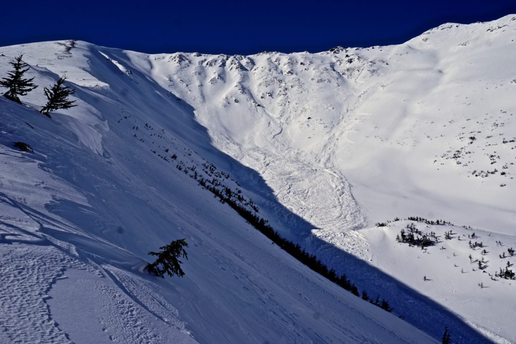
Natural avalanche on a NE aspect of Raggedtop was first noticed Tuesday morning and is a good example of the size and distance a very large avalanche could run. 


An avalanche triggered Tuesday in Girdwood near Notch Mountain at 2500′. This slab was 3-6′ deep and failed on facets on top of a slick crust, bed surface. 


Avalanche Problem 2
  • Wind Slabs
    Wind Slabs
  • Almost Certain
    Very Likely
    Likely
    Possible
    Unlikely
    Likelihood
  • Historic (D4-5)
    Very Large (D3)
    Large (D2)
    Small (D1)
    Size
Wind Slabs
Wind Slab avalanches are the release of a cohesive layer of snow (a slab) formed by the wind. Wind typically transports snow from the upwind sides of terrain features and deposits snow on the downwind side. Wind slabs are often smooth and rounded and sometimes sound hollow, and can range from soft to hard. Wind slabs that form over a persistent weak layer (surface hoar, depth hoar, or near-surface facets) may be termed Persistent Slabs or may develop into Persistent Slabs.

Likelihood of Avalanches
Terms such as "unlikely", "likely", and "certain" are used to define the scale, with the chance of triggering or observing avalanches increasing as we move up the scale. For our purposes, "Unlikely" means that few avalanches could be triggered in avalanche terrain and natural avalanches are not expected. "Certain" means that humans will be able to trigger avalanches on many slopes, and natural avalanches are expected.

Size of Avalanches
Avalanche size is defined by the largest potential avalanche, or expected range of sizes related to the problem in question. Assigned size is a qualitative estimate based on the destructive classification system and requires specialists to estimate the harm avalanches may cause to hypothetical objects located in the avalanche track (AAA 2016, CAA 2014). Under this schema, "Small" avalanches are not large enough to bury humans and are relatively harmless unless they carry people over cliffs or through trees or rocks. Moving up the scale, avalanches become "Large" enough to bury, injure, or kill people. "Very Large" avalanches may bury or destroy vehicles or houses, and "Historic" avalanches are massive events capable of altering the landscape.

Signal Word Size (D scale) Simple Descriptor
Small 1 Unlikely to bury a person
Large 2 Can bury a person
Very Large 3 Can destroy a house
Historic 4 & 5 Can destroy part or all of a village
More info at Avalanche.org

Wind Slabs: Wind slabs have formed on a variety of aspects due to unusual loading patterns and cross loading from strong Northwest winds this week. Smooth supportable surfaces where the snow is hollow sounding are suspect, especially if the slope is unsupported. Look for cracking and identify terrain features with a pillow-shaped look where triggering a wind slab could break above you. Warming from the sun can make triggering easier in the afternoon, and a wind slab could step down to older snow and create a much deeper and more dangerous avalanche.

Cornices: Cornices are large and looming and the sun and above freezing temperatures can make them more unstable. Give cornices lots of space and limit exposure underneath them.  


Northern aspect of Magnum with recent wind loading from several days of strong NW winds. In Turnagain Pass this wind direction can funnel through some terrain from the South and load Northern aspects. 

Weather
Fri, March 23rd, 2018

Yesterday skis were clear and Northwest winds were to 5-15mph. Day time high temperatures near sea level were in the mid 30F’s and overnight dipped into the teens F. Upper elevation temperatures became slightly inverted – with temperatures increasing from low teens (F) yesterday morning to mid 20F’s overnight. No precipitation was recorded.  

Today expect skies to remain clear and sunny.   Winds will be light and variable. Daytime temperatures may reach the mid 30F’s in the upper elevations and low 40F’s at sea level. Overnight temperatures will drop back into the teens F at all elevations.  

Saturday will be partly cloudy with light winds similar daily temperatures (15F – 35F.) Sunday will be overcast as Low pressure moves into our region with the first chance for precip Sunday evening into Monday. At this point precipitation type and amounts are uncertain.  

PRECIPITATION 24-hour data (6am – 6am)

  Temp Avg (F) Snow (in) Water (in) Snow Depth (in)
Center Ridge (1880′) 21    0 0   80  
Summit Lake (1400′) 14   0   0   32  
Alyeska Mid (1700′) 20   0   0   75  

RIDGETOP 24-hour data (6am – 6am)

  Temp Avg (F) Wind Dir Wind Avg (mph) Wind Gust (mph)
Sunburst (3812′)        
Seattle Ridge (2400′)        
Observations
Recent Observations for Turnagain Pass
Date Region Location
05/22/23 Turnagain Avalanche: Tincan
05/12/23 Turnagain Avalanche: Tincan, Sunburst, Magnum, Cornbiscuit
05/07/23 Turnagain Observation: Tincan – Bear Tracks
05/05/23 Turnagain Observation: Seattle Ridge
05/02/23 Turnagain Observation: Cornbiscuit
05/02/23 Turnagain Observation: Seward Hwy Turnagain Pass
04/30/23 Turnagain Observation: Magnum
04/29/23 Turnagain Observation: Tincan
04/28/23 Turnagain Avalanche: Taylor Pass/Pastoral
04/28/23 Turnagain Avalanche: Tincan
Riding Areas
Updated Thu, June 01st, 2023

Status of riding areas across the Chugach NF is managed by the Glacier and Seward Ranger Districts, not avalanche center staff. Riding area information is posted as a public service to our users and updated based on snow depth and snow density to prevent resource damage at trailhead locations. Riding area questions contact: mailroom_r10_chugach@fs.fed.us

Area Status Weather & Riding Conditions
Glacier District
Johnson Pass
Closed
Closed May 15.
Placer River
Closed
Closed May 15.
Skookum Drainage
Closed
Will close to motorized use on April 1, 2023 per the National Forest Plan.
Turnagain Pass
Closed
Will close on June 1.
Twentymile
Closed
Scheduled closure May 1.
Seward District
Carter Lake
Closed
Scheduled closure May 1.
Lost Lake Trail
Closed
Scheduled closure May 1.
Primrose Trail
Closed
Scheduled closure May 1.
Resurrection Pass Trail
Closed
Closed to motorized use for the 2022/23 winter season per Forest Plan. Open next season.
Snug Harbor
Closed
Extended opening until May 15.
South Fork Snow River Corridor
Closed
Scheduled closure May 1.
Summit Lake
Closed
Scheduled closure May 1.

Subscribe to Turnagain Pass
Avalanche Forecast by Email

This is a general backcountry avalanche advisory issued for Turnagain Arm with Turnagain Pass as the core advisory area. This advisory does not apply to highways, railroads or operating ski areas.