Turnagain Pass RSS

Archives
ARCHIVED - Forecasts expire after 24 hours.
Issued
Thu, March 15th, 2018 - 7:00AM
Expires
Fri, March 16th, 2018 - 7:00AM
Forecaster
Graham Predeger
Avalanche risk The Bottom Line

There is a CONSIDERABLE avalanche danger today at all elevations. We’ve seen natural or human-triggered avalanches everyday since Monday and our snowpack structure is such that snowmachiners and skiers may trigger an avalanche from a distance or the bottom of a slope today.   Be mindful of avalanche run-out zones and what is above you.   Cautious route finding and conservative decision-making will be essential. Large slab avalanches 2-4′ thick failing naturally will also be possible if we see daytime warming ahead of this next storm.      

Special Announcements

All skier and snowmachiner parking lots throughout Turnagain Pass have been plowed as of yesterday.   Thanks DOT!!

Thu, March 15th, 2018
Alpine
Above 2,500'
3 - Considerable
Avalanche risk
Treeline
1,000'-2,500'
3 - Considerable
Avalanche risk
Below Treeline
Below 1,000'
3 - Considerable
Avalanche risk
0 - No Rating
1 - Low
2 - Moderate
3 - Considerable
4 - High
5 - Extreme
Avalanche risk Avalanche risk Avalanche risk Avalanche risk Avalanche risk
Travel Advice Generally safe avalanche conditions. Watch for unstable snow on isolated terrain features. Heightened avalanche conditions on specific terrain features. Evaluate snow and terrain carefully; identify features of concern. Dangerous avalanche conditions. Careful snowpack evaluation, cautious route-finding, and conservative decision-making essential. Very dangerous avalanche conditions. Travel in avalanche terrain not recommended. Extraordinarily dangerous avalanche conditions. Avoid all avalanche terrain.
Likelihood of Avalanches Natural and human-triggered avalanches unlikely. Natural avalanches unlikely; human-triggered avalanches possible. Natural avalanches possible; human-triggered avalanches likely. Natural avalanches likely; human-triggered avalanches very likely. Natural and human-triggered avalanches certain.
Avalanche Size and Distribution Small avalanches in isolated areas or extreme terrain. Small avalanches in specific areas; or large avalanches in isolated areas. Small avalanches in many areas; or large avalanches in specific areas; or very large avalanches in isolated areas. Large avalanches in many areas; or very large avalanches in specific areas. Very large avalanches in many areas.
Avalanche Problem 1
  • Persistent Slabs
    Persistent Slabs
  • Certain
    Very Likely
    Likely
    Possible
    Unlikely
    Likelihood
  • Historic (D4-5)
    Very Large (D3)
    Large (D2)
    Small (D1)
    Size
Persistent Slabs
Persistent Slab avalanches are the release of a cohesive layer of snow (a slab) in the middle to upper snowpack, when the bond to an underlying persistent weak layer breaks. Persistent layers include: surface hoar, depth hoar, near-surface facets, or faceted snow. Persistent weak layers can continue to produce avalanches for days, weeks or even months, making them especially dangerous and tricky. As additional snow and wind events build a thicker slab on top of the persistent weak layer, this avalanche problem may develop into a Deep Persistent Slab.

Likelihood of Avalanches
Terms such as "unlikely", "likely", and "certain" are used to define the scale, with the chance of triggering or observing avalanches increasing as we move up the scale. For our purposes, "Unlikely" means that few avalanches could be triggered in avalanche terrain and natural avalanches are not expected. "Certain" means that humans will be able to trigger avalanches on many slopes, and natural avalanches are expected.

Size of Avalanches
Avalanche size is defined by the largest potential avalanche, or expected range of sizes related to the problem in question. Assigned size is a qualitative estimate based on the destructive classification system and requires specialists to estimate the harm avalanches may cause to hypothetical objects located in the avalanche track (AAA 2016, CAA 2014). Under this schema, "Small" avalanches are not large enough to bury humans and are relatively harmless unless they carry people over cliffs or through trees or rocks. Moving up the scale, avalanches become "Large" enough to bury, injure, or kill people. "Very Large" avalanches may bury or destroy vehicles or houses, and "Historic" avalanches are massive events capable of altering the landscape.

Signal Word Size (D scale) Simple Descriptor
Small 1 Unlikely to bury a person
Large 2 Can bury a person
Very Large 3 Can destroy a house
Historic 4 & 5 Can destroy part or all of a village
More info at Avalanche.org

Weak layers deeper in the snowpack appear to have been the culprit in multiple natural and human-triggered avalanches since Monday.  Yesterday a skier-triggered avalanche caught and carried 3 skiers in small terrain on Silvertip (southern Turnagain Pass) on a NE aspect around 1500’.  On Tuesday we saw a natural avalanche cycle fire off in the Placer/ Skookum zone with several small and one very large avalanche (perhaps 1-mile wide), triggered by warming temperatures and high clouds producing a greenhouse effect in the afternoon hours.  And Monday saw two remote-triggered avalanches on the periphery of Turnagain Pass (Grandview and Summit Lake) in addition to two skier-triggered avalanches on Sunburst.  With the 2-5’ of fresh snow over the weekend, persistent weak layers have inched ever closer to the tipping point.  Skiers, snowmachiners and changing (warming) weather have all proved sufficient triggers this week. 

Things to keep in mind if heading into the backcountry today:

  • Any avalanche initiated will likely be 2’+ deep and has potential to propagate in big terrain.
  • Solar radiation and warm air temperatures can quickly make the snowpack unstable this time of year. Natural avalanches will be possible
  • Avalanches are being triggered from the flats or remotely from an adjacent slope – avoid runout zones
  • Ease into steeper terrain slowly. Evaluate consequences; if the slope releases will debris pile into a terrain trap?
  • You may not see any red flags or signs of instability with a persistent slab problem before an avalanche.

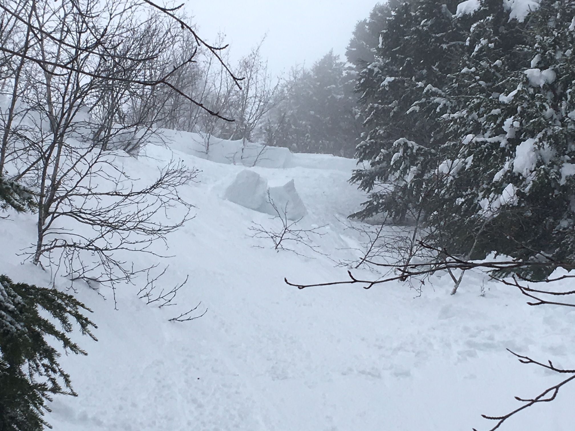
Multiple natural avalanches initiated by warming on Tuesday afternoon in the Skookum/ Lubner Lake area, Placer Valley.

Skier-triggered avalanche on lower Silvertip yesterday.  More info on Observations page.  

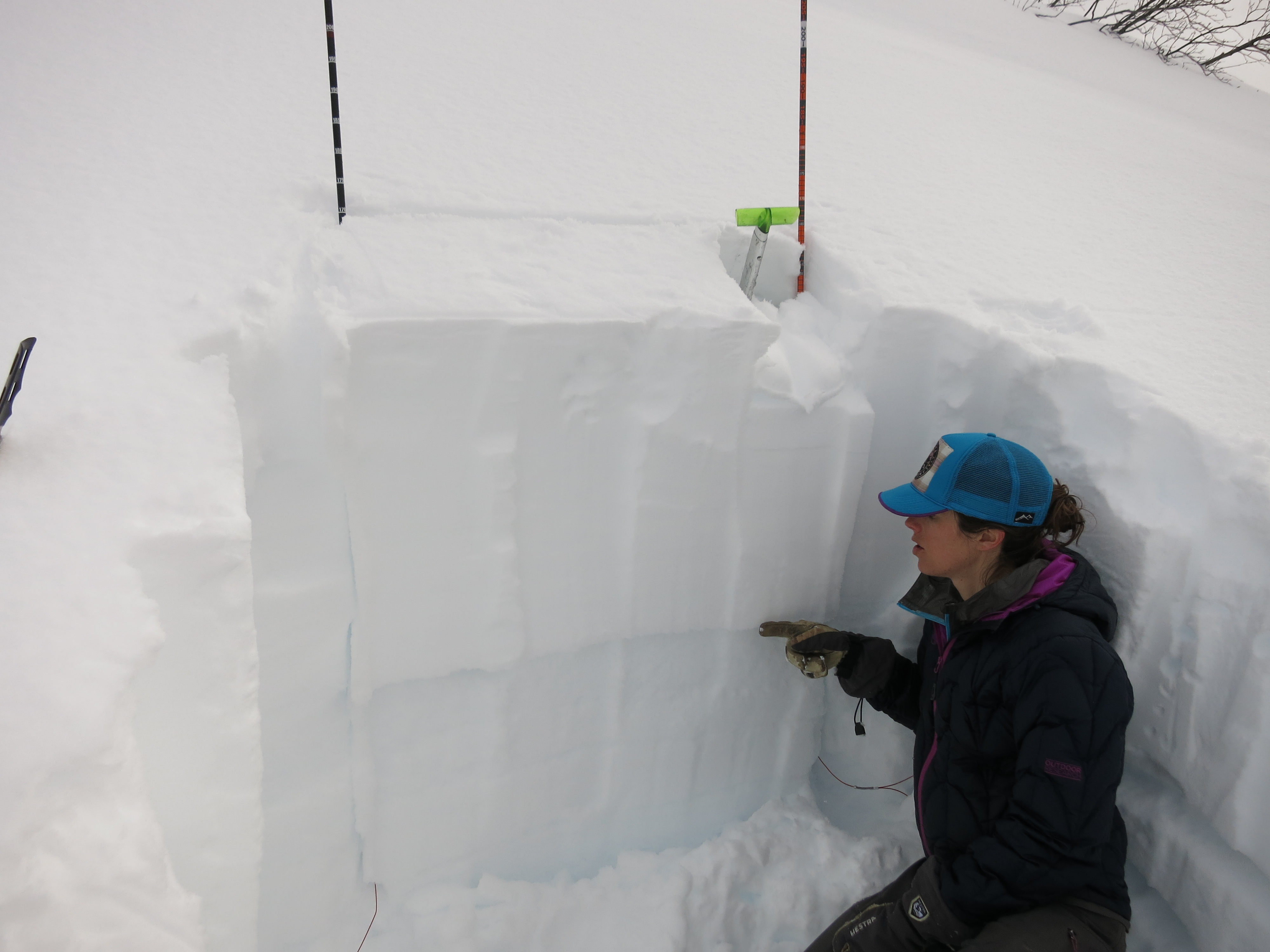
CNFAIC intern Jessie Haffener having no trouble finding the common weak layer in many of this week’s avalanches.  In this case it’s about 25-30″ deep on Pete’s North at ~2,100′.


Avalanche Problem 2
  • Wet Loose
    Wet Loose
  • Certain
    Very Likely
    Likely
    Possible
    Unlikely
    Likelihood
  • Historic (D4-5)
    Very Large (D3)
    Large (D2)
    Small (D1)
    Size
Wet Loose
Wet Loose avalanches are the release of wet unconsolidated snow or slush. These avalanches typically occur within layers of wet snow near the surface of the snowpack, but they may quickly gouge into lower snowpack layers. Like Loose Dry Avalanches, they start at a point and entrain snow as they move downhill, forming a fan-shaped avalanche. Other names for loose-wet avalanches include point-release avalanches or sluffs. Loose Wet avalanches can trigger slab avalanches that break into deeper snow layers.

Likelihood of Avalanches
Terms such as "unlikely", "likely", and "certain" are used to define the scale, with the chance of triggering or observing avalanches increasing as we move up the scale. For our purposes, "Unlikely" means that few avalanches could be triggered in avalanche terrain and natural avalanches are not expected. "Certain" means that humans will be able to trigger avalanches on many slopes, and natural avalanches are expected.

Size of Avalanches
Avalanche size is defined by the largest potential avalanche, or expected range of sizes related to the problem in question. Assigned size is a qualitative estimate based on the destructive classification system and requires specialists to estimate the harm avalanches may cause to hypothetical objects located in the avalanche track (AAA 2016, CAA 2014). Under this schema, "Small" avalanches are not large enough to bury humans and are relatively harmless unless they carry people over cliffs or through trees or rocks. Moving up the scale, avalanches become "Large" enough to bury, injure, or kill people. "Very Large" avalanches may bury or destroy vehicles or houses, and "Historic" avalanches are massive events capable of altering the landscape.

Signal Word Size (D scale) Simple Descriptor
Small 1 Unlikely to bury a person
Large 2 Can bury a person
Very Large 3 Can destroy a house
Historic 4 & 5 Can destroy part or all of a village
More info at Avalanche.org

Wet loose avalanches or roller balls today are indicative of solar radiation and/ or warming temperatures affecting change on the snowpack.  These have potential to trigger larger, more dangerous slabs, particularly on southerly and easterly slopes greater than 30 degrees. 

Additional Concern
  • Cornice
    Cornice
Cornice
Cornice Fall is the release of an overhanging mass of snow that forms as the wind moves snow over a sharp terrain feature, such as a ridge, and deposits snow on the downwind (leeward) side. Cornices range in size from small wind drifts of soft snow to large overhangs of hard snow that are 30 feet (10 meters) or taller. They can break off the terrain suddenly and pull back onto the ridge top and catch people by surprise even on the flat ground above the slope. Even small cornices can have enough mass to be destructive and deadly. Cornice Fall can entrain loose surface snow or trigger slab avalanches.
More info at Avalanche.org

Cornices:

Cornices have grown significantly since the March 9th storm began and deposited several feet of new snow accompanied by strong winds.  Give corniced ridges an extra wide berth and minimize time spent below as a cornice fall can trigger and propagate an avalanche on a slope below.

Roof avalanches:

This is a serious concern, particularly around Girdwood this time of year.  Be mindful of where children and pets are playing, vehicles parked and entrances to buildings in relation to loaded roofs.  Often times warming temperatures after a large storm is enough to begin seeing roofs shed snow.  When a roof avalanches, it’s likely to shed the entire snowpack all at once.  

Weather
Thu, March 15th, 2018

Yesterday’s weather turned out to be a bit more unsettled than previously forecasted.   Temperatures hovered in the mid to low 30’s from sea level to 1,000′ and was just cold enough to keep precipitation as snow to sea level.   1-3″ of wet snow accumulated throughout the day and winds were light from the West.

Today temperatures look to be a bit warmer reaching into the mid-30’s at sea level and we may see a rain/ snow mix.   Forecasted precipitation is minimal today (trace to 1″ snow above 1,000′) ahead of our next weather producer that arrives in southcentral this evening.   More on that below.   Winds will start off light from the SE today and increase into the 20’s and 30’s mph this evening.    

Tonight and into tomorrow a fast moving storm from the Southwest will impact our area.   This looks to be a bit warmer than our last storm and will be accompanied by stronger winds thru Turnagain Arm from the SE.   By Friday night/ Saturday models show an upper level ridge building over southcentral Alaska and a partly to mostly sunny weekend on tap.

PRECIPITATION 24-hour data (6am – 6am)

  Temp Avg (F) Snow (in) Water (in) Snow Depth (in)
Center Ridge (1880′)  31  1 .1   88  
Summit Lake (1400′) 30   0    0  33
Alyeska Mid (1700′)  28  2  .3  81

RIDGETOP 24-hour data (6am – 6am)

  Temp Avg (F) Wind Dir Wind Avg (mph) Wind Gust (mph)
Sunburst (3812′) 20    W 4   12  
Seattle Ridge (2400′)  25  WNW 4   10  
Observations
Recent Observations for Turnagain Pass
Date Region Location
04/21/24 Turnagain Observation: Bertha Creek
04/20/24 Turnagain Avalanche: Spokane Creek
04/16/24 Turnagain Observation: Cornbiscuit
04/15/24 Turnagain Observation: Taylor Pass
04/15/24 Turnagain Observation: Seward Highway – Tern Lake to Portage
04/14/24 Turnagain Observation: Sunburst
04/14/24 Turnagain Observation: Turnagain Pass Snomo
04/13/24 Turnagain Observation: Spokane Creek
04/11/24 Turnagain Observation: Tincan
04/10/24 Turnagain Avalanche: Seattle Ridge
Riding Areas

The riding areas page has moved. Please click here & update your bookmarks.


Subscribe to Turnagain Pass
Avalanche Forecast by Email

This is a general backcountry avalanche advisory issued for Turnagain Arm with Turnagain Pass as the core advisory area. This advisory does not apply to highways, railroads or operating ski areas.