Turnagain Pass Avalanche Forecast
|
![]() ![]() |
The avalanche danger is CONSIDERABLE. Large slab avalanches 2-4+ feet thick are likely to be triggered on slopes steeper than 30 degrees. These may be triggered from a distance or from the bottom of a slope. Cautious route finding and conservative decision-making are essential. If the sun comes out today natural avalanches are possible, especially on southerly and easterly slopes. Pay attention to changing conditions.
A skier remotely triggered an avalanche on the skin track in Summit Lake Monday – see Saturday’s Summit snowpack and avalanche summary and recent observations HERE.
There will be intermittent traffic delays Wednesday March 14, 2018 on the Seward Highway for avalanche hazard reduction work. Near mileposts 100 to 95, Bird Flats. Motorists should expect delays of up to 45 minutes between 10:00 AM and 2:00 PM. Updates will be posted on the 511 system. http://511.alaska.gov/
Signal Word | Size (D scale) | Simple Descriptor |
Small | 1 | Unlikely to bury a person |
Large | 2 | Can bury a person |
Very Large | 3 | Can destroy a house |
Historic | 4 & 5 | Can destroy part or all of a village |
What happens when you mix rapid warming and buried weak layers??? March Madness? Welcome to spring…Yesterday was an interesting day for avalanches. The sun came out, temperatures rose (some weather stations recorded temperatures into the 40Fs), high clouds came in and the heat was trapped. This “greenhousing” is believed to have been the cause of a natural avalanche cycle that started mid day and peaked around 5 pm. The highlight of this was a large natural slab avalanche that was observed on an NE aspect of Skookum. This appears to have run on the mid January facet/crust combination that has been a layer of concern in mid elevation terrain. This layer seems to be the culprit in the majority of the avalanche activity since last week’s storm. What does this mean for today? We know that there is a slab approximately 2-4 feet thick over persistent weak layers that have been well documented and that are widespread across our region. Large avalanches can be triggered by the weight of a skier or snowmachiner, especially in a thinner spot near rocks or ridges. There were avalanches triggered on Monday. If the sun comes out today there is the potential that a similar warm up may happen and naturals will be possible. It is important to recognize that the snowpack can be even more unstable as warm air and solar radiation affect cold snow and buried weak layers. Extra caution is advised.
If you are headed out into the backcountry today things to keep in mind are:
Natural slab avalanche in Skookum that released around 5 pm.
Natural slab on Seattle Ridge that releases around 1 pm.
Crown of one of the skier triggered Sunburst avalanches that occcurred Monday.
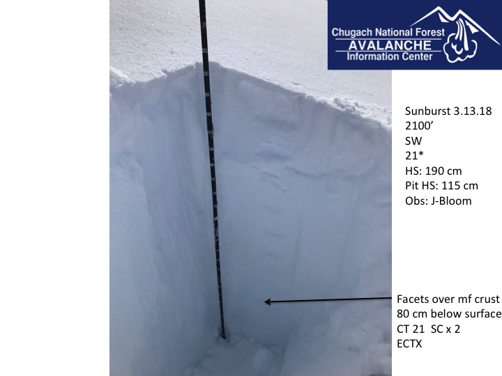
Mid elevation layer of concern: buried facets over a melt freeze crust.
Signal Word | Size (D scale) | Simple Descriptor |
Small | 1 | Unlikely to bury a person |
Large | 2 | Can bury a person |
Very Large | 3 | Can destroy a house |
Historic | 4 & 5 | Can destroy part or all of a village |
Solar radiation and warm temperatures yesterday caused widespread wet loose avalanches. Some of these also triggered slabs on Southerly and Easterly slopes. If the sun comes out today pay attention to changing conditions. Naturals may run and could surprise you in the wrong spot. Wet loose avalanches may also be triggered from your skis or snowmachine in steep terrain on the solar aspects.
Natural wet loose avalanches and a slab avalanche on Seattle Ridge yesterday
Cornices: Cornices have grown and are suspect for breaking while traveling along ridgelines. Give these an extra wide berth and minimize any time below them. Cornice falls can trigger avalanches on slopes below.
Wind slabs: Shallow wind slabs formed on some leeward features Monday due to moderate Easterly winds in the Alpine. Triggering a wind slab will likely be shallow, but could step down to a deeper layer of the snowpack and create a much larger and more dangerous avalanche.
Yesterday skies cleared earlier than forecasted and the sun came out. High clouds built in the afternoon.Temperatures rose into the low 30Fs to mid 40Fs. Winds were Easterly 5-15 mph gusting into the 30s. Skies became cloudy overnight and temperatures dropped into the 20Fs and low 30Fs. Winds shifted to the west and were light.
Today will be mostly cloudy in the morning but could become sunny in the afternoon. There is a chance of snow showers in the morning. Winds are forecast to be light and Northwesterly. Temperatures will be in the 20Fs to high 30Fs. Tonight will be mostly cloudy with temperatures in the 20Fs to low 30Fs and calm winds.
Tomorrow the next system approaches form the Southwest bringing snow showers in the afternoon and increasing winds. Snow is in the forecast into Friday. Stay tuned for snow amounts. The NWS described a persistent unsettled pattern continuing into next week.
Temp Avg (F) | Snow (in) | Water (in) | Snow Depth (in) | |
Center Ridge (1880′) | 35 | 0 | 0 | 87 |
Summit Lake (1400′) | 30 | 0 | 0 | 35 |
Alyeska Mid (1700′) | 34 | 1 | .11 | 79 |
Temp Avg (F) | Wind Dir | Wind Avg (mph) | Wind Gust (mph) | |
Sunburst (3812′) | 25 | E-W | 9 | 34 |
Seattle Ridge (2400′) | 29 | E | 10 | 32 |
Date | Region | Location | Observer |
---|---|---|---|
05/22/23 | Turnagain | Avalanche: Tincan | Nick D'Alessio |
05/12/23 | Turnagain | Avalanche: Tincan, Sunburst, Magnum, Cornbiscuit | Heather Thamm |
05/07/23 | Turnagain | Observation: Tincan – Bear Tracks | CNFAIC Staff |
05/05/23 | Turnagain | Observation: Seattle Ridge | AS/ WW Forecaster |
05/02/23 | Turnagain | Observation: Cornbiscuit | Schauer/ Sturgess Forecaster |
05/02/23 | Turnagain | Observation: Seward Hwy Turnagain Pass | Joel Curtis |
04/30/23 | Turnagain | Observation: Magnum | Ayla, Kit Crosby, Barton |
04/29/23 | Turnagain | Observation: Tincan | John Sykes |
04/28/23 | Turnagain | Avalanche: Taylor Pass/Pastoral | Schauer/ Creighton Forecaster |
04/28/23 | Turnagain | Avalanche: Tincan | Andy Moderow |
Status of riding areas across the Chugach NF is managed by the Glacier and Seward Ranger Districts, not avalanche center staff. Riding area information is posted as a public service to our users and updated based on snow depth and snow density to prevent resource damage at trailhead locations. Riding area questions contact: mailroom_r10_chugach@fs.fed.us
Area | Status | Weather & Riding Conditions |
---|---|---|
Glacier District |
Subscribe to Turnagain Pass
Avalanche Forecast by Email
This is a general backcountry avalanche advisory issued for Turnagain Arm with Turnagain Pass as the core advisory area. This advisory does not apply to highways, railroads or operating ski areas.