![]() |
![]() |
![]() |
![]() |
![]() |
|
Travel Advice | Generally safe avalanche conditions. Watch for unstable snow on isolated terrain features. | Heightened avalanche conditions on specific terrain features. Evaluate snow and terrain carefully; identify features of concern. | Dangerous avalanche conditions. Careful snowpack evaluation, cautious route-finding, and conservative decision-making essential. | Very dangerous avalanche conditions. Travel in avalanche terrain not recommended. | Extraordinarily dangerous avalanche conditions. Avoid all avalanche terrain. |
Likelihood of Avalanches | Natural and human-triggered avalanches unlikely. | Natural avalanches unlikely; human-triggered avalanches possible. | Natural avalanches possible; human-triggered avalanches likely. | Natural avalanches likely; human-triggered avalanches very likely. | Natural and human-triggered avalanches certain. |
Avalanche Size and Distribution | Small avalanches in isolated areas or extreme terrain. | Small avalanches in specific areas; or large avalanches in isolated areas. | Small avalanches in many areas; or large avalanches in specific areas; or very large avalanches in isolated areas. | Large avalanches in many areas; or very large avalanches in specific areas. | Very large avalanches in many areas. |
Signal Word | Size (D scale) | Simple Descriptor |
Small | 1 | Unlikely to bury a person |
Large | 2 | Can bury a person |
Very Large | 3 | Can destroy a house |
Historic | 4 & 5 | Can destroy part or all of a village |
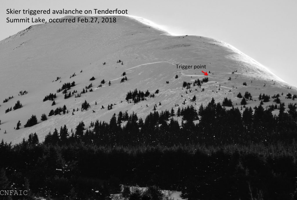
As we anticipate a storm tomorrow it is good to remember the current state of the snowpack. Observers continue to find the buried persistent weak layers in the snowpack to be reactive and today the possibility of triggering a large avalanche remains. At the mid-elevations, buried 1-2′ deep are facets sitting on a crust and at the higher elevations, 1-3′ deep is a buried surface hoar/facet combo. The slab over the weak layers could be very hard if it is in terrain that was affected by the strong winds last week. This was the case in the skier triggered avalanche in Summit Lake a week ago, the mid-elevation faceted layer was under very hard wind-affected snow. Although the heart of Turnagain Pass has the buried weak layers, they are more pronounced and developed on the Southern end of Turnagain Pass and in Summit Lake where the snowpack is shallower. On Monday an observer found the buried surface hoar in Lynx Creek, described the snowpack as “spooky” and changed their plan due to concerning snowpit test results. Areas to the North, such as Crow Pass, are also suspect along with those that have not seen much traffic this season. Using safe travel protocols and assessing the consequences if a slab does release is key in choosing terrain. Weak layers like these can become more reactive after even a small additional load. As the snow falls this week keep that in mind and as always be alert for signs of instability. If we do get heavy snow tomorrow expect the avalanche danger to rise quickly.
Wind slabs: Hard wind-affected snow on steep, unsupported slopes may still triggered if you find the wrong spot. Be suspect of very stiff snow over soft snow or hollow sounding snow near upper elevation ridgelines and cross-loaded gullies. In addition, yesterday afternoon the winds picked up blowing from the East and gusting into the 30s. Look for cracking and very shallow, fresh wind slabs near ridgelines.
Solar warming/effects: Sunshine this afternoon may allow for enough warming to initiate roller balls and small wet loose avalanches on steep Southerly aspects. Warming may also cause slabs to be more reactive; something to keep in mind as we choose our late afternoon terrain.
State of the snowpack before the storm…
The Tenderfoot avalanche that occured last week due to very hard wind-affected snow over the buried facet/crust combination.
Yesterday was mostly cloudy with light snow showers in the afternoon into the evening with little overall accumulation. Temperatures were in the teens to mid 20Fs. Winds were picked up in the afternoon blowing Easterly 10-20 mph with gusts into the 30s.
Today will start cloudy and become partly sunny in the afternoon during a small window before the next system moves in. Temperatures will be in the 20Fs to low 30Fs. Winds will be light and Northerly. Clouds move in again in this evening with snow showers overnight. Winds will shift back to the East and temperatures will be in the upper teens to mid 20Fs.
There is still some uncertainty in the storm track that is forecast to impact the area tomorrow. The difference of the low moving into Cook Inlet versus Prince William Sound will affect how much precipitation the advisory area gets. There is a good possibility that we will see some periods of heavy snow and stronger winds. The timing and snow amounts are still to be determined. Stay tuned!
Temp Avg (F) | Snow (in) | Water (in) | Snow Depth (in) | |
Center Ridge (1880′) | 25 | trace | 0 | 67 |
Summit Lake (1400′) | 18 | trace | 0 | 29 |
Alyeska Mid (1700′) | 22 | 1.4 | 0.11 | 59 |
RIDGETOP 24-hour data (6am – 6am)
Temp Avg (F) | Wind Dir | Wind Avg (mph) | Wind Gust (mph) | |
Sunburst (3812′) | 13 | ENE | 11 | 31 |
Seattle Ridge (2400′) | 19 | ESE | 15 | 32 |
Date | Region | Location | Observer |
---|---|---|---|
10/27/24 | Turnagain | Observation: Tincan | Michael Kerst |
10/21/24 | Turnagain | Observation: Turnagain Pass Road Observation | Trevor Clayton |
10/19/24 | Turnagain | Observation: Tincan – Below Todds Run | Andy Moderow |
10/18/24 | Turnagain | Observation: Taylor Pass | Eli Neuffer |
10/15/24 | Turnagain | Observation: Tincan Common | John Sykes Forecaster |
10/14/24 | Turnagain | Avalanche: Tincan | CNFAC Staff |
05/13/24 | Turnagain | Observation: Eddie’s, Sunburst, Seattle, Cornbiscuit, Pete’s South | H Thamm |
05/13/24 | Turnagain | Observation: Turnagain Pass non-motorized side | Amy Holman |
05/12/24 | Turnagain | Observation: Warm up Bowl | Tony Naciuk |
05/07/24 | Turnagain | Observation: Turnagain Pass Wet Slabs | A S |
The riding areas page has moved. Please click here & update your bookmarks.
Subscribe to Turnagain Pass
Avalanche Forecast by Email