Turnagain Pass RSS

Archives
ARCHIVED - Forecasts expire after 24 hours.
Issued
Thu, March 1st, 2018 - 7:00AM
Expires
Fri, March 2nd, 2018 - 7:00AM
Forecaster
Heather Thamm
Avalanche risk The Bottom Line

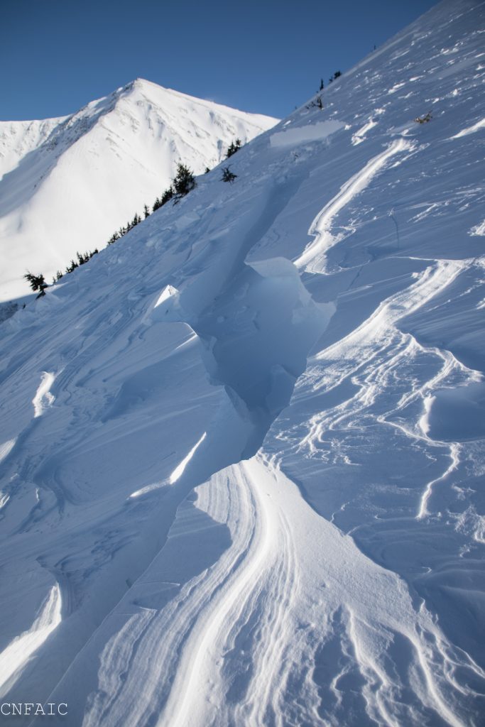
The avalanche danger is  MODERATE  at all elevations due strong winds over the past two days. Human triggered wind slabs 1-2′ thick will be possible, and radiation from the sun could make slabs easier to initiate in the afternoon on solar aspects. Additionally,  old weak layers deeper in the pack may be triggered, creating a larger avalanche.  

Numerous natural avalanches occurred in Summit Lake yesterday and a human triggered avalanche occurred the day before on Tenderfoot. Read the Saturday Summit Summary  HERE  and current observations  HERE.  

Special Announcements

Lost Lake Trail, Primrose Trail,  South Fork Snow River Corridor and 20 Mile are all open for motorized use.  At 20 Mile please cross the railroad tracks at the designated spot as you leave the parking area.

If heading to Lost Lake area check out several observations describing two snowmachine triggered avalanches that occurred over the last two days HERE.  

Thu, March 1st, 2018
Alpine
Above 2,500'
2 - Moderate
Avalanche risk
Treeline
1,000'-2,500'
2 - Moderate
Avalanche risk
Below Treeline
Below 1,000'
2 - Moderate
Avalanche risk
0 - No Rating
1 - Low
2 - Moderate
3 - Considerable
4 - High
5 - Extreme
Avalanche risk Avalanche risk Avalanche risk Avalanche risk Avalanche risk
Travel Advice Generally safe avalanche conditions. Watch for unstable snow on isolated terrain features. Heightened avalanche conditions on specific terrain features. Evaluate snow and terrain carefully; identify features of concern. Dangerous avalanche conditions. Careful snowpack evaluation, cautious route-finding, and conservative decision-making essential. Very dangerous avalanche conditions. Travel in avalanche terrain not recommended. Extraordinarily dangerous avalanche conditions. Avoid all avalanche terrain.
Likelihood of Avalanches Natural and human-triggered avalanches unlikely. Natural avalanches unlikely; human-triggered avalanches possible. Natural avalanches possible; human-triggered avalanches likely. Natural avalanches likely; human-triggered avalanches very likely. Natural and human-triggered avalanches certain.
Avalanche Size and Distribution Small avalanches in isolated areas or extreme terrain. Small avalanches in specific areas; or large avalanches in isolated areas. Small avalanches in many areas; or large avalanches in specific areas; or very large avalanches in isolated areas. Large avalanches in many areas; or very large avalanches in specific areas. Very large avalanches in many areas.
Avalanche Problem 1
  • Wind Slabs
    Wind Slabs
  • Certain
    Very Likely
    Likely
    Possible
    Unlikely
    Likelihood
  • Historic (D4-5)
    Very Large (D3)
    Large (D2)
    Small (D1)
    Size
Wind Slabs
Wind Slab avalanches are the release of a cohesive layer of snow (a slab) formed by the wind. Wind typically transports snow from the upwind sides of terrain features and deposits snow on the downwind side. Wind slabs are often smooth and rounded and sometimes sound hollow, and can range from soft to hard. Wind slabs that form over a persistent weak layer (surface hoar, depth hoar, or near-surface facets) may be termed Persistent Slabs or may develop into Persistent Slabs.

Likelihood of Avalanches
Terms such as "unlikely", "likely", and "certain" are used to define the scale, with the chance of triggering or observing avalanches increasing as we move up the scale. For our purposes, "Unlikely" means that few avalanches could be triggered in avalanche terrain and natural avalanches are not expected. "Certain" means that humans will be able to trigger avalanches on many slopes, and natural avalanches are expected.

Size of Avalanches
Avalanche size is defined by the largest potential avalanche, or expected range of sizes related to the problem in question. Assigned size is a qualitative estimate based on the destructive classification system and requires specialists to estimate the harm avalanches may cause to hypothetical objects located in the avalanche track (AAA 2016, CAA 2014). Under this schema, "Small" avalanches are not large enough to bury humans and are relatively harmless unless they carry people over cliffs or through trees or rocks. Moving up the scale, avalanches become "Large" enough to bury, injure, or kill people. "Very Large" avalanches may bury or destroy vehicles or houses, and "Historic" avalanches are massive events capable of altering the landscape.

Signal Word Size (D scale) Simple Descriptor
Small 1 Unlikely to bury a person
Large 2 Can bury a person
Very Large 3 Can destroy a house
Historic 4 & 5 Can destroy part or all of a village
More info at Avalanche.org

Yesterday a big wind event impacted Southcentral Alaska and unfortunately Turnagain Pass was not spared. Large plumes of blowing snow were observed on most ridgetops as well as scouring, anti-tracks, wind sculpted snow. We received several reports of small natural wind slabs releasing on the SW face of Tincan yesterday and could see fresh debris in a Northern chute of Corn Biscuit. Numerous wind triggered avalanches occurred in Summit Lake area as well as a large avalanche on a Northern aspect near Silvertip Creek. (More on this below.) Active wind loading occurred on the SE face of Seattle Ridge, but on the other side of the road the wind direction was funneling through terrain from the South at times. Be aware of wind slabs on a variety of aspects due to unusual wind loading patterns and cross loading. Triggering a hard supportable wind slab will be possible and could step down to a deeper persistent layer and propagate along larger slopes. Identify smooth or pillow-shaped surfaces in steep terrain where triggering a wind slab could break above you, once committed to a slope. Supportable surfaces where the snow is hollow sounding should also be suspect. 

Sunshine:  If winds are calm today radiation from the sun could make wind slabs more reactive in steep terrain on Southerly aspects. Pay attention to surface snow melting or point releases near rocks in steep terrain. The sun can also add stress to cornices and make them easier to trigger. 

Strong winds blowing snow onto a Southern aspect of Tincan yesterday, but wind loading was also observed on Northern aspects yesterday. 


 Winds loading the SE face of Seattle Ridge yesterday.

Avalanche Problem 2
  • Persistent Slabs
    Persistent Slabs
  • Certain
    Very Likely
    Likely
    Possible
    Unlikely
    Likelihood
  • Historic (D4-5)
    Very Large (D3)
    Large (D2)
    Small (D1)
    Size
Persistent Slabs
Persistent Slab avalanches are the release of a cohesive layer of snow (a slab) in the middle to upper snowpack, when the bond to an underlying persistent weak layer breaks. Persistent layers include: surface hoar, depth hoar, near-surface facets, or faceted snow. Persistent weak layers can continue to produce avalanches for days, weeks or even months, making them especially dangerous and tricky. As additional snow and wind events build a thicker slab on top of the persistent weak layer, this avalanche problem may develop into a Deep Persistent Slab.

Likelihood of Avalanches
Terms such as "unlikely", "likely", and "certain" are used to define the scale, with the chance of triggering or observing avalanches increasing as we move up the scale. For our purposes, "Unlikely" means that few avalanches could be triggered in avalanche terrain and natural avalanches are not expected. "Certain" means that humans will be able to trigger avalanches on many slopes, and natural avalanches are expected.

Size of Avalanches
Avalanche size is defined by the largest potential avalanche, or expected range of sizes related to the problem in question. Assigned size is a qualitative estimate based on the destructive classification system and requires specialists to estimate the harm avalanches may cause to hypothetical objects located in the avalanche track (AAA 2016, CAA 2014). Under this schema, "Small" avalanches are not large enough to bury humans and are relatively harmless unless they carry people over cliffs or through trees or rocks. Moving up the scale, avalanches become "Large" enough to bury, injure, or kill people. "Very Large" avalanches may bury or destroy vehicles or houses, and "Historic" avalanches are massive events capable of altering the landscape.

Signal Word Size (D scale) Simple Descriptor
Small 1 Unlikely to bury a person
Large 2 Can bury a person
Very Large 3 Can destroy a house
Historic 4 & 5 Can destroy part or all of a village
More info at Avalanche.org

Triggering a large slab avalanche 2+ feet thick is possible due to several buried weak layers within our snowpack. Recent snow this week combined with strong winds have added stress to the snowpack. More potential exists in places with a shallow snowpack like the Southern end of Turnagain Pass and Summit Lake zone. This was evident yesterday during the wind event where numerous large avalanches released naturally near Silvertip Creek and in Summit Lake. In the heart of Turnagain Pass we have been tracking several weak layers buried 1-2 feet deep  (facets and buried surface hoar) and both have been reactive in stability tests. The tricky part about this avalanche problem is that these slabs are hard and supportable and may be difficult to assess. Yesterday we investigated a human triggered slab avalanche on Tenderfoot (from Tuesday) where the slab was disguised as hard sastrugi. Obvious clues like “whumpfing” or shooting cracks may not be present before a slope releases. Assess the terrain for consequences and remember that the bigger the terrain the bigger the consequences. 

Deep Persistent Slabs: Keep in mind that there are deeper persistent layers that could ‘wake up’ if you find the wrong spot above 3,000′ in the Alpine. At these high elevations, old weak layers of facets and buried surface hoar sit in the bottom half of the snowpack. This structure is also more pronounced in places with a thin overall snow cover, such as the South end of Turnagain Pass, the Summit Lake area and Crow Pass. 

Two large natural avalanches observed yesterday on the ridge East of Silvertip Creek, NE slope 


Facets over a rain crust have been showing propagation potential in the mid elevation zone. This pit was in the Center Ridge area yesterday. Photo by Nick D’Alessio 


Weather
Thu, March 1st, 2018

Clear skies and strong NW winds impacted Southcentral, Alaska yesterday. Seattle weather station recorded 30-50mph NW wind most of the day, while Sunburst station was more protected from this direction and recorded West winds in the 10-30mph range.   Overnight NW winds decreased to Moderate. Temperatures in the upper elevations remained in the single digits F all day yesterday while lower elevations increased into the teens F’s during the day. No precipitation was recorded.  

Today will start out with clear skies becoming cloudy this evening. Winds will continue to mellow out and become light from the NW. Temperatures may be inverted in some areas with single digits in valley bottoms and ridge tops in the teens F to low 20F’s. No precipitation is expected.  

Into this weekend temperatures will gradually increase into the 20F’s at all elevations and there’s a chance for snow showers Saturday. Winds are expected to remain the light to moderate range.  

*Center Ridge and Summit Lake weather stations are currently down and data after 1pm (2/28/18) is unavailable.  

PRECIPITATION 24-hour data (6am – 6am)

  Temp Avg (F) Snow (in) Water (in) Snow Depth (in)
Center Ridge (1880′) *16   0   0   72  
Summit Lake (1400′) *14   0   0   30  
Alyeska Mid (1700′) 13   0   0   62  

RIDGETOP 24-hour data (6am – 6am)

  Temp Avg (F) Wind Dir Wind Avg (mph) Wind Gust (mph)
Sunburst (3812′) 5    W 10   39  
Seattle Ridge (2400′) 11    NNW 22   62  
Observations
Recent Observations for Turnagain Pass
Date Region Location
04/16/24 Turnagain Observation: Cornbiscuit
04/15/24 Turnagain Observation: Taylor Pass
04/15/24 Turnagain Observation: Seward Highway – Tern Lake to Portage
04/14/24 Turnagain Observation: Sunburst
04/14/24 Turnagain Observation: Turnagain Pass Snomo
04/13/24 Turnagain Observation: Spokane Creek
04/11/24 Turnagain Observation: Tincan
04/10/24 Turnagain Avalanche: Seattle Ridge
04/10/24 Turnagain Observation: Cornbiscuit South Face
04/10/24 Turnagain Avalanche: Tincan
Riding Areas

The riding areas page has moved. Please click here & update your bookmarks.


Subscribe to Turnagain Pass
Avalanche Forecast by Email

This is a general backcountry avalanche advisory issued for Turnagain Arm with Turnagain Pass as the core advisory area. This advisory does not apply to highways, railroads or operating ski areas.