Turnagain Pass Avalanche Forecast
|
![]() ![]() |
A generally LOW avalanche danger exists in the mountains surrounding Turnagain Pass. Although triggering an avalanche large enough to bury a person is unlikely, isolated slabs 1-2′ deep can still be found in steep and/or wind loaded areas. LOW danger does not mean No Danger. Evaluate the consequences of terrain before committing to a slope. Additionally, watch for cornices along ridgelines and sluffs in steep terrain.
*In the periphery zones of Girdwood to Portage Valley, and Johnson Pass to Summit Lake more caution is advised where a slab could be larger and more connected.
Check out the Summit Lake Summary HERE.
Signal Word | Size (D scale) | Simple Descriptor |
Small | 1 | Unlikely to bury a person |
Large | 2 | Can bury a person |
Very Large | 3 | Can destroy a house |
Historic | 4 & 5 | Can destroy part or all of a village |
Another brilliant sunny day is on tap and with that, another day for folks to travel well into the mountains. This is the 10th day of cold and clear weather, which has been steadily increasing the stability of the snowpack. Tracks litter most slopes around Turnagain Pass, and though we have moved into a LOW danger regime, there still remains isolated areas where a person can trigger a slab avalanche. We saw this yesterday in the Twin Peaks area where a foot deep slab was triggered by a party on the uptrack. There were already many tracks on the slope when it released and skiers were ascending the same track they used earlier that day. There was one person caught on the slab who was able to get off it quickly and luckily no one was carried down. This area is on the Southern edge of the forecast zone, in the periphery, where a shallower snowpack exists.
If you are headed out today, keep the following avalanche problems in mind:
Persistent Slabs: A layer of buried surface hoar exists roughly 1-2′ deep and has been responsible for the scattered avalanche activity over the past 10 days. Last night a report came in from Eddies SW face where two people were caught and carried in a slab last Friday (all are ok). Again several tracks were on the slope before a person found just the wrong spot that presumably had prior wind loading. Amongst all the soft snow out there, watch for these pockets where winds have stiffened and/or loaded areas. These are the most likely places to find an isolated slab. Although most of these slabs have been relatively small, larger slabs could be lurking as was found in the Twin Peaks zone. If choosing to push into the steep and committing terrain, identify terrain traps like gullies, cliffs or rocks below to consider the consequences if even a small slab is released. Again, in the periphery areas of Girdwood, Placer Valley, Johnson Pass and Summit Lake more caution is advised due to higher winds last week and the potential for larger slabs to be found.
*Deep Persistent Slab: Weak snow can still be found near the ground at the upper most elevations in our forecast area, 3,000′ – 5,000′. Although triggering a Deep Persistent Slab is very unlikely, it is worth keeping in mind that poor structure does exist at the high elevations.
Loose Snow ‘sluffs’: In most places the snow is too loose to form a slab and the surface snow ’sluffs’ easily on the steeper slopes. Expect loose dry snow to be fast moving in steep terrain and don’t be surprised if it knocks you over as it picks up speed. Manage your ‘sluff’ and be aware of the consequences below you.
Cornices: Cornices are unpredictable and can break further back along a ridge than expected. Give these features plenty of space.
Pictured below is the avalanche triggered on Twin Peaks Saturday, Feb 3rd. This slab is thin, ~ a foot thick, but shows wide propagation across the slope (photo: Andy DuComb).
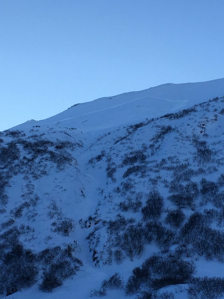
View of skin track with crown of the slab on Twin Peaks (photo: Mark Norquist)
–
Another cold and clear sky day was had yesterday in the mountains. While single digits temperatures remained in place in valley bottoms, ridgetops climbed into the teens F. Ridgetop winds were Easterly and generally light, 5-10mph with a few gusts reaching 20mph. An impressive inversion is yet again in place this morning with Johnson Pass trailhead at -16F while ridgetops (Sunburst and Seattle Ridge) are close to 20F.
Today will see sunny skies once again, yet warmer air is slowly sliding in from the East. Ridgetops have bumped to near 20F as of this morning and could increase to the mid-20’s today. Ridgetop winds are forecast to be light and variable, shifting Easterly in the 5-10mph range tonight. Valley bottoms are likely to remain generally chilly through the day.
For tomorrow, Monday, the blocking high-pressure over Alaska will begin to push North and allow a moist low-pressure system to move into Southcentral. Clouds and warmer temperatures are expected to stream in Monday. Early Tuesday morning this system “will be delivering a fresh batch of snow to the Kenai Peninsula and Prince William Sound” according to the National Weather Service. Stay tuned!
Temp Avg (F) | Snow (in) | Water (in) | Snow Depth (in) | |
Center Ridge (1880′) | 19 | 0 | 0 | 62 |
Summit Lake (1400′) | 9 | 0 | 0 | 18 |
Alyeska Mid (1700′) | 18 | 0 | 0 | 50 |
Temp Avg (F) | Wind Dir | Wind Avg (mph) | Wind Gust (mph) | |
Sunburst (3812′) | 16 | NE | 8 | 21 |
Seattle Ridge (2400′) | 19 | SE | 6 | 14 |
Date | Region | Location | Observer |
---|---|---|---|
05/22/23 | Turnagain | Avalanche: Tincan | Nick D'Alessio |
05/12/23 | Turnagain | Avalanche: Tincan, Sunburst, Magnum, Cornbiscuit | Heather Thamm |
05/07/23 | Turnagain | Observation: Tincan – Bear Tracks | CNFAIC Staff |
05/05/23 | Turnagain | Observation: Seattle Ridge | AS/ WW Forecaster |
05/02/23 | Turnagain | Observation: Cornbiscuit | Schauer/ Sturgess Forecaster |
05/02/23 | Turnagain | Observation: Seward Hwy Turnagain Pass | Joel Curtis |
04/30/23 | Turnagain | Observation: Magnum | Ayla, Kit Crosby, Barton |
04/29/23 | Turnagain | Observation: Tincan | John Sykes |
04/28/23 | Turnagain | Avalanche: Taylor Pass/Pastoral | Schauer/ Creighton Forecaster |
04/28/23 | Turnagain | Avalanche: Tincan | Andy Moderow |
Status of riding areas across the Chugach NF is managed by the Glacier and Seward Ranger Districts, not avalanche center staff. Riding area information is posted as a public service to our users and updated based on snow depth and snow density to prevent resource damage at trailhead locations. Riding area questions contact: mailroom_r10_chugach@fs.fed.us
Area | Status | Weather & Riding Conditions |
---|---|---|
Glacier District |
Subscribe to Turnagain Pass
Avalanche Forecast by Email
This is a general backcountry avalanche advisory issued for Turnagain Arm with Turnagain Pass as the core advisory area. This advisory does not apply to highways, railroads or operating ski areas.