Turnagain Pass RSS

Archives
ARCHIVED - Forecasts expire after 24 hours.
Issued
Tue, January 24th, 2017 - 7:00AM
Expires
Wed, January 25th, 2017 - 7:00AM
Forecaster
Heather Thamm
Avalanche risk The Bottom Line

CONSIDERABLE  avalanche danger exists in the alpine surrounding Turnagain Pass where triggering a wind slab avalanche up to 2-3 feet thick will be likely on steep leeward slopes. At Treeline and below the avalanche danger is MODERATE where triggering a loose snow avalanche or a soft slab up to 1′ thick is possible. Recent snowfall,15-24 €, combined with rising temperatures may be adding stress to older layers within the snowpack, and triggering a deeper more connected slab may be possible today on larger steep slopes. Careful snowpack evaluation, cautious route-finding and conservative decision-making are essential if venturing into the alpine today.  

Girdwood Valley:  Slabs and loose snow avalanches (sluffs) both have the potential to be larger due to more snow that has fallen over the weekend compared to Turngain Pass. Also heads up for roof avalanches as rising temperatures will make these unsupported slopes unstable.  

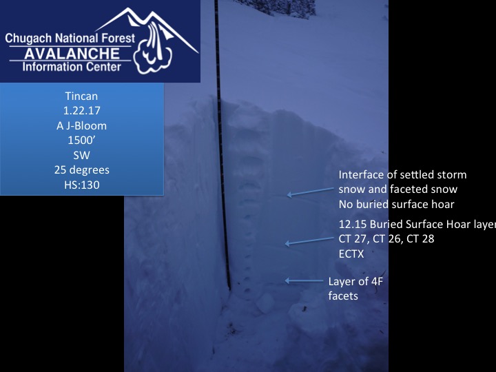
Placer Valley: In the lower elevations (below 2,000′) watch for persistent soft slab avalanches up to 2 feet thick that could release on a layer of buried surface hoar.  

Summit Lake:  Rising temperatures, recent snowfall and a generally weaker snowpack has the potential for dangerous avalanche conditions.  Please check out the Saturday Summit Summary  HERE.  

Special Announcements

Dangerous avalanche conditions exist in many area around South-central Alaska including the Anchorage Front Range, Hatcher Pass, and Southern Kenai Mountains.  

  • Click HERE for details about a skier triggered avalanche in South Fork Eagle River.  
  • Click  HERE  for the Hatcher Pass Avalanche Center advisory and  HERE  for recent snowpack observations.
  • Attention! If heading to the Southern Kenai Mountains, including the Lost Lake zone, this region is out of the advisory area but has received 3-5 feet of snow from Saturday’s storm  that has fallen on a reported thin/weak snowpack.  The photo below is one of several avalanches in Lost Lake on Fireman’s side from this last weekend. Photo by Chad Winberg.

Tue, January 24th, 2017
Alpine
Above 2,500'
3 - Considerable
Avalanche risk
Treeline
1,000'-2,500'
2 - Moderate
Avalanche risk
Below Treeline
Below 1,000'
2 - Moderate
Avalanche risk
0 - No Rating
1 - Low
2 - Moderate
3 - Considerable
4 - High
5 - Extreme
Avalanche risk Avalanche risk Avalanche risk Avalanche risk Avalanche risk
Travel Advice Generally safe avalanche conditions. Watch for unstable snow on isolated terrain features. Heightened avalanche conditions on specific terrain features. Evaluate snow and terrain carefully; identify features of concern. Dangerous avalanche conditions. Careful snowpack evaluation, cautious route-finding, and conservative decision-making essential. Very dangerous avalanche conditions. Travel in avalanche terrain not recommended. Extraordinarily dangerous avalanche conditions. Avoid all avalanche terrain.
Likelihood of Avalanches Natural and human-triggered avalanches unlikely. Natural avalanches unlikely; human-triggered avalanches possible. Natural avalanches possible; human-triggered avalanches likely. Natural avalanches likely; human-triggered avalanches very likely. Natural and human-triggered avalanches certain.
Avalanche Size and Distribution Small avalanches in isolated areas or extreme terrain. Small avalanches in specific areas; or large avalanches in isolated areas. Small avalanches in many areas; or large avalanches in specific areas; or very large avalanches in isolated areas. Large avalanches in many areas; or very large avalanches in specific areas. Very large avalanches in many areas.
Avalanche Problem 1
  • Storm Slabs
    Storm Slabs
Storm Slabs
Storm Slab avalanches are the release of a cohesive layer (a slab) of new snow that breaks within new snow or on the old snow surface. Storm-slabs typically last between a few hours and few days (following snowfall). Storm-slabs that form over a persistent weak layer (surface hoar, depth hoar, or near-surface facets) may be termed Persistent Slabs or may develop into Persistent Slabs.
More info at Avalanche.org

Wind Slabs: Yesterday Northeast winds on Sunburst weather station recorded sustained 30-40 mph winds with gusts in the mid 70’s mph. These strong Easterly ridge top winds combined with 8” of new snow have formed fresh wind slabs in the Alpine. There was also plenty of snow available for transport and these wind slabs have the potential to be 2-3’ thick on leeward features. Heavier warmer snow due to rising temperatures are likely to have made these slabs even more reactive. In many places in the alpine these wind slabs are resting on old hard wind crust from the wind event prior to this weekend’s storm. This combination was found in steep terrain in the upper elevations over the weekend where several skier triggered avalanche occured. Today it will be best to avoid loaded slopes steeper than 35 degrees. Feel for hollow feeling snow, stiffer snow over softer snow or slab sitting on hard snow and watch for cracks that shoot out from your snowmachine, skis or board. 

Storm slabs/Loose Snow avalanches: In places protected from yesterday’s winds storm slabs and loose snow avalanches are possible on steep terrain features. These are likely to be the top 8” of new snow. These are not likely to be large enough to bury a person, but could catch you by surprise. Avoid steep terrain traps where even a small storm slab or sluff could have high consiqences.  

Cornices are also expected to be tender today and could break off naturally or with the weight of a person or snow machine. If you find yourself along a ridge, give these unpredictable hazards extra space and avoid being directly beneath one. 

Roof avalanches: Heads up near building with loaded roof tops as warming temperatures today through Thursday will makes these unsupported slopes unstable. Many roofs have 2-3’ of heavy dense snow from the last few weeks, which is plenty of snow to bury a child, pet or seriously injury a kill an adult. 


Avalanche Problem 2
  • Persistent Slabs
    Persistent Slabs
Persistent Slabs
Persistent Slab avalanches are the release of a cohesive layer of snow (a slab) in the middle to upper snowpack, when the bond to an underlying persistent weak layer breaks. Persistent layers include: surface hoar, depth hoar, near-surface facets, or faceted snow. Persistent weak layers can continue to produce avalanches for days, weeks or even months, making them especially dangerous and tricky. As additional snow and wind events build a thicker slab on top of the persistent weak layer, this avalanche problem may develop into a Deep Persistent Slab.
More info at Avalanche.org

A variety of persistant weak layers exist within the snowpack and vary across our region. In most cases these layers have been generally dormant. Incremental loading over the last four days has added stress to these older layers. In shallower parts of the area there are developed basal facets and in many locations there is a mid-pack layer of facets from December. At the lower elevations, below 2,000′, a layer of buried surface hoar exists under the last two snowfall events (1.5-2 feet below the surface). Slab avalanches failing on this layer are possible where the snow on top is stiff enough to form a slab. Warming temperatures today and through the next few days will make the slab more cohesive increasing the potential for a large more connected slab. The lower terrain in Placer Valley is an area that may have a similar set up. All of these layers are important to remember, especially if we receive a significant load in the next couple of days!!!

An example of the snowpack in the lower elevations at Tincan where a variety of weak layers remain the snowpack.

Weather
Tue, January 24th, 2017

Yesterday temperatures were on the rise at lower elevations reaching 32F near sea level and 30 F at 1000.’ About 8 € of new snow fell throughout the day and into the evening in Turnagain Pass and Girdwood. Easterly ridgetop winds increased from moderate to strong late afternoon, averaging in the 30’s mph with gusts in the mid 70’s mph at Sunburst Weather Station. Overnight ridgetop winds decreased to moderate from the East.

Today temperatures will remain warm near 32F below 1000′. Easterly ridgetop winds are expected to diminish, becoming light by early afternoon. Scattered snow showers are possible, with up to 3-6 € throughout the day.  

A warming trend is expected to continue through the week as a series of low pressure systems bringing more precipitation to Southcentral, AK. Wednesday evening thru Thursday rain is expected at the lower elevations as temperatures rise to the mid 30’s F with heavy snowfall in the upper elevations. Ridgetop winds are also expected to increase.

PRECIPITATION 24-hour data (6am – 6am)

  Temp Avg (F) Snow (in) Water (in) Snow Depth (in)
Center Ridge (1880′) 27   8   .8   52  
Summit Lake (1400′) 26   1   .1   24  
Alyeska Mid (1700′) 26   8   .8   53  

RIDGETOP 24-hour data (6am – 6am)

  Temp Avg (F) Wind Dir Wind Avg (mph) Wind Gust (mph)
Sunburst (3812′) 18   ENE   27   74  
Seattle Ridge (2400′) 20   SE   22   55  
Observations
Recent Observations for Turnagain Pass
Date Region Location
04/16/24 Turnagain Observation: Cornbiscuit
04/15/24 Turnagain Observation: Taylor Pass
04/15/24 Turnagain Observation: Seward Highway – Tern Lake to Portage
04/14/24 Turnagain Observation: Sunburst
04/14/24 Turnagain Observation: Turnagain Pass Snomo
04/13/24 Turnagain Observation: Spokane Creek
04/11/24 Turnagain Observation: Tincan
04/10/24 Turnagain Avalanche: Seattle Ridge
04/10/24 Turnagain Observation: Cornbiscuit South Face
04/10/24 Turnagain Avalanche: Tincan
Riding Areas

The riding areas page has moved. Please click here & update your bookmarks.


Subscribe to Turnagain Pass
Avalanche Forecast by Email

This is a general backcountry avalanche advisory issued for Turnagain Arm with Turnagain Pass as the core advisory area. This advisory does not apply to highways, railroads or operating ski areas.