Turnagain Pass RSS

Archives
ARCHIVED - Forecasts expire after 24 hours.
Issued
Tue, February 9th, 2016 - 7:00AM
Expires
Wed, February 10th, 2016 - 7:00AM
Forecaster
Graham Predeger
Avalanche risk The Bottom Line

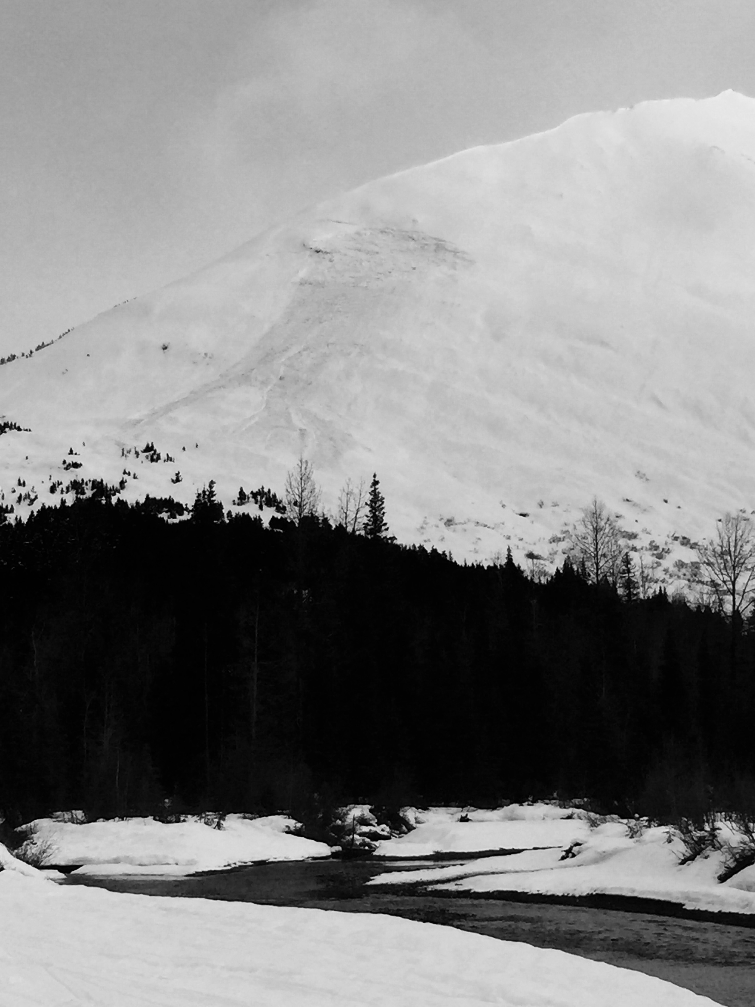
The avalanche danger is MODERATE today above treeline where fresh wind slabs 1-2′ thick will be possible to trigger on freshly wind-loaded slopes.   Cornices are also of serious concern in the alpine as they are large and tender right now.   In the mid-elevation band, glide cracks are numerous and avalanching full depth, generally on their own schedule.  

Note: The Girdwood Valley saw a lot more precipitation than Turnagain pass yesterday (see weather table below).   If headed into the backcountry around Girdwood expect fresh storm snow instabilities in addition to wind slabs and cornices.

Special Announcements

The Chugach National Forest Avalanche Information Center and Friends of the Chugach Avalanche Information Center are pleased to announce the launch of an observations program partnership with Hatcher Pass Avalanche Center.

By clicking the €œObservations € link on both  hatcherpassavalanche.org  and  www.cnfaic.org, users can now browse and submit Hatcher Pass observations. Data is mirrored on both sites giving Southcentral Alaska backcountry enthusiasts the ability to quickly browse recent snowpack and avalanche observations throughout the region.  Please  submit your own observations  and spread the word to others.  Huge thanks to all those folks who have already submitted observations!

Save the dates! Hatcher Pass Avalanche Center and Friends of the CNFAIC are also joining forces to support FREE avalanche education at Hatcher Pass and in Palmer. There will be a FREE companion rescue workshop on Saturday, February 13th, 10:30am-12:30pm, Hatcher Pass Gold Mint Lot and a FREE avalanche awareness class Wednesday, February 17th, 6:30-8pm, Palmer High School Library. Click  HERE  for more info!

Tue, February 9th, 2016
Alpine
Above 2,500'
2 - Moderate
Avalanche risk
Treeline
1,000'-2,500'
2 - Moderate
Avalanche risk
Below Treeline
Below 1,000'
0 - No Rating
Avalanche risk
0 - No Rating
1 - Low
2 - Moderate
3 - Considerable
4 - High
5 - Extreme
Avalanche risk Avalanche risk Avalanche risk Avalanche risk Avalanche risk
Travel Advice Generally safe avalanche conditions. Watch for unstable snow on isolated terrain features. Heightened avalanche conditions on specific terrain features. Evaluate snow and terrain carefully; identify features of concern. Dangerous avalanche conditions. Careful snowpack evaluation, cautious route-finding, and conservative decision-making essential. Very dangerous avalanche conditions. Travel in avalanche terrain not recommended. Extraordinarily dangerous avalanche conditions. Avoid all avalanche terrain.
Likelihood of Avalanches Natural and human-triggered avalanches unlikely. Natural avalanches unlikely; human-triggered avalanches possible. Natural avalanches possible; human-triggered avalanches likely. Natural avalanches likely; human-triggered avalanches very likely. Natural and human-triggered avalanches certain.
Avalanche Size and Distribution Small avalanches in isolated areas or extreme terrain. Small avalanches in specific areas; or large avalanches in isolated areas. Small avalanches in many areas; or large avalanches in specific areas; or very large avalanches in isolated areas. Large avalanches in many areas; or very large avalanches in specific areas. Very large avalanches in many areas.
Avalanche Problem 1
  • Wind Slabs
    Wind Slabs
  • Certain
    Very Likely
    Likely
    Possible
    Unlikely
    Likelihood
  • Historic (D4-5)
    Very Large (D3)
    Large (D2)
    Small (D1)
    Size
Wind Slabs
Wind Slab avalanches are the release of a cohesive layer of snow (a slab) formed by the wind. Wind typically transports snow from the upwind sides of terrain features and deposits snow on the downwind side. Wind slabs are often smooth and rounded and sometimes sound hollow, and can range from soft to hard. Wind slabs that form over a persistent weak layer (surface hoar, depth hoar, or near-surface facets) may be termed Persistent Slabs or may develop into Persistent Slabs.

Likelihood of Avalanches
Terms such as "unlikely", "likely", and "certain" are used to define the scale, with the chance of triggering or observing avalanches increasing as we move up the scale. For our purposes, "Unlikely" means that few avalanches could be triggered in avalanche terrain and natural avalanches are not expected. "Certain" means that humans will be able to trigger avalanches on many slopes, and natural avalanches are expected.

Size of Avalanches
Avalanche size is defined by the largest potential avalanche, or expected range of sizes related to the problem in question. Assigned size is a qualitative estimate based on the destructive classification system and requires specialists to estimate the harm avalanches may cause to hypothetical objects located in the avalanche track (AAA 2016, CAA 2014). Under this schema, "Small" avalanches are not large enough to bury humans and are relatively harmless unless they carry people over cliffs or through trees or rocks. Moving up the scale, avalanches become "Large" enough to bury, injure, or kill people. "Very Large" avalanches may bury or destroy vehicles or houses, and "Historic" avalanches are massive events capable of altering the landscape.

Signal Word Size (D scale) Simple Descriptor
Small 1 Unlikely to bury a person
Large 2 Can bury a person
Very Large 3 Can destroy a house
Historic 4 & 5 Can destroy part or all of a village
More info at Avalanche.org

Today is expected to be a bit of an ‘in-between-storms’ type of day as we usher out yesterday’s windy and wet (Girdwood) weather and gear up for more active weather and a warm-up before the weekend.  Winds were steady in the 25-40 mph range for much of yesterday with gusts in the 60’s mph on Sunburst.  With substantial snow available for transport in the alpine, wind slabs 1-2’ deep will be possible to trigger.  For skiers, quick hand shears or probing with your pole will be a good way to identify areas where strong (wind slab) over weak snow exists in the alpine.  For snowmachiners, look for small, no-consequence test slopes to cut with your machine.  Any shooting cracks or hollow-feeling snow is indicative of a reactive wind slab.  Generally, these will be found on leeward terrain, with a southerly or westerly tilt today.

CORNICES:

Cornices are notorious for catching people off guard and can break much further back than you might expect.  Travel well away from the edge of a corniced ridge in order to give yourself that extra wide berth.  Warming temperatures, direct sun and generally, any changing weather will continue to push these closer to failing naturally.

Avalanche Problem 2
  • Glide Avalanches
    Glide Avalanches
  • Certain
    Very Likely
    Likely
    Possible
    Unlikely
    Likelihood
  • Historic (D4-5)
    Very Large (D3)
    Large (D2)
    Small (D1)
    Size
Glide Avalanches
Glide Avalanches are the release of the entire snow cover as a result of gliding over the ground. Glide avalanches can be composed of wet, moist, or almost entirely dry snow. They typically occur in very specific paths, where the slope is steep enough and the ground surface is relatively smooth. They are often proceeded by full depth cracks (glide cracks), though the time between the appearance of a crack and an avalanche can vary between seconds and months. Glide avalanches are unlikely to be triggered by a person, are nearly impossible to forecast, and thus pose a hazard that is extremely difficult to manage.

Likelihood of Avalanches
Terms such as "unlikely", "likely", and "certain" are used to define the scale, with the chance of triggering or observing avalanches increasing as we move up the scale. For our purposes, "Unlikely" means that few avalanches could be triggered in avalanche terrain and natural avalanches are not expected. "Certain" means that humans will be able to trigger avalanches on many slopes, and natural avalanches are expected.

Size of Avalanches
Avalanche size is defined by the largest potential avalanche, or expected range of sizes related to the problem in question. Assigned size is a qualitative estimate based on the destructive classification system and requires specialists to estimate the harm avalanches may cause to hypothetical objects located in the avalanche track (AAA 2016, CAA 2014). Under this schema, "Small" avalanches are not large enough to bury humans and are relatively harmless unless they carry people over cliffs or through trees or rocks. Moving up the scale, avalanches become "Large" enough to bury, injure, or kill people. "Very Large" avalanches may bury or destroy vehicles or houses, and "Historic" avalanches are massive events capable of altering the landscape.

Signal Word Size (D scale) Simple Descriptor
Small 1 Unlikely to bury a person
Large 2 Can bury a person
Very Large 3 Can destroy a house
Historic 4 & 5 Can destroy part or all of a village
More info at Avalanche.org

We’ve still got literally hundreds of glide cracks littering the mid-elevations in and around Turnagain Pass.  Many of these may not release at all, but we continue to see large and destructive glide cracks avalanching in or adjacent to popular ski terrain.  Completely unpredictable, it’s best to minimize your exposure to this volatile avalanche problem by avoiding time spent below glide cracks.  

Recent glide release on Pete’s South.  This avalanched sometime Saturday night or Sunday morning.  The photo’s really don’t do it justice, this is a large and destructive avalanche!

Additional Concern
  • Persistent Slabs
    Persistent Slabs
Persistent Slabs
Persistent Slab avalanches are the release of a cohesive layer of snow (a slab) in the middle to upper snowpack, when the bond to an underlying persistent weak layer breaks. Persistent layers include: surface hoar, depth hoar, near-surface facets, or faceted snow. Persistent weak layers can continue to produce avalanches for days, weeks or even months, making them especially dangerous and tricky. As additional snow and wind events build a thicker slab on top of the persistent weak layer, this avalanche problem may develop into a Deep Persistent Slab.
More info at Avalanche.org

Observations yesterday from the Lynx Creek drainage (South of Turnagain Pass) found a layer of buried surface hoar (BSH).  Likely deposited during the high-pressure weekend of Jan.30/31, it’s now buried by a 2-3’ slab.  Our one data point yesterday showed the BSH to be unreactive.  That is the good news, but given the nature of persistent weak layers, I’m not comfortable going all-in quite yet.  This is a similar structure to what Wendy and I found on Jan.31st, one drainage to the East… Buried surface hoar was unreactive in our pit, a mere quarter mile away from a very large and connected snowmachine-triggered avalanche from the previous day.  Bottom line: Don’t trust a hoar.


Weather
Tue, February 9th, 2016

Low clouds and incessant rain pounded the Girdwood and Portage Valleys most of the day while the lucky few continued their march toward Turnagain Pass and partly sunny skies!   Temperatures were hovering around 32 degrees at the Pass with cloud cover in and out throughout the day with only about an inch of new snow.   Ridetop winds were steady in the 25-40mph range, gusting in the 60’s.   The Girdwood Valley received the lion share of precipitation yesterday measuring .85 € of water and about 9 € of snow at Alyeska mid-mountain (1700′).

Today we can expect partly cloudy skies with an overall clearing trend toward tonight.   We may see a couple inches of new snow and light rain below about 1200′.   Winds will be moderate from the East in the 15-25mph range.

This next round of storms will begin impacting our area from the South tomorrow/ tomorrow night.   Unfortunately temps look to be unseasonably warm with this next shot of active weather.

PRECIPITATION 24-hour data (6am – 6am)

  Temp Avg (F) Snow (in) Water (in) Snow Depth (in)
Center Ridge (1880′)  30 1    .1 109  
Summit Lake (1400′) 31.5   1   .1   31  
Alyeska Mid (1700′)  31.5 9    .85 95  

RIDGETOP 24-hour data (6am – 6am)

  Temp Avg (F) Wind Dir Wind Avg (mph) Wind Gust (mph)
Sunburst (3812′)  24  ENE 17   65  
Seattle Ridge (2400′) 26   n/a   n/a   n/a  
Observations
Recent Observations for Turnagain Pass
Date Region Location
04/16/24 Turnagain Observation: Cornbiscuit
04/15/24 Turnagain Observation: Taylor Pass
04/15/24 Turnagain Observation: Seward Highway – Tern Lake to Portage
04/14/24 Turnagain Observation: Sunburst
04/14/24 Turnagain Observation: Turnagain Pass Snomo
04/13/24 Turnagain Observation: Spokane Creek
04/11/24 Turnagain Observation: Tincan
04/10/24 Turnagain Avalanche: Seattle Ridge
04/10/24 Turnagain Observation: Cornbiscuit South Face
04/10/24 Turnagain Avalanche: Tincan
Riding Areas

The riding areas page has moved. Please click here & update your bookmarks.


Subscribe to Turnagain Pass
Avalanche Forecast by Email

This is a general backcountry avalanche advisory issued for Turnagain Arm with Turnagain Pass as the core advisory area. This advisory does not apply to highways, railroads or operating ski areas.