Turnagain Pass Avalanche Forecast RSS

Archives
ARCHIVED FORECAST - All forecasts expire after 24 hours from the posting date/time.
Issued
Sun, December 13th, 2015 - 7:00AM
Expires
Mon, December 14th, 2015 - 7:00AM
Forecaster
Heather Thamm
Avalanche risk The Bottom Line

The avalanche danger is CONSIDERABLE both in the Alpine and at Treeline elevations where a 2-3′ thick slab is sitting on various layers of weak snow. Today is the perfect recipe for an avalanche accident €”it is the opening day of snowmachining in Turnagain Pass plus clear skies following a big storm.   Lots of people are anticipated to hit the slopes today. It is EXTRA important to not group up under large slopes, travel one at a time, and tread lightly.  

Below Treeline there is a MODERATE  avalanche danger.  The new snow is showing signs of good bonding; though keep in mind we are still within 48 hours of a storm, and if an avalanche was triggered from above it could run into this elevation band.  

*A Blizzard Warning has been issued by the National Weather Service starting at 6pm this evening through Portage Valley and Turnagain Arm. Avalanche danger will likely be increasing after dark with increasing winds and snowfall. Watch for deteriorating conditions in the afternoon and give yourself plenty of time to return home safely.  


Special Announcements

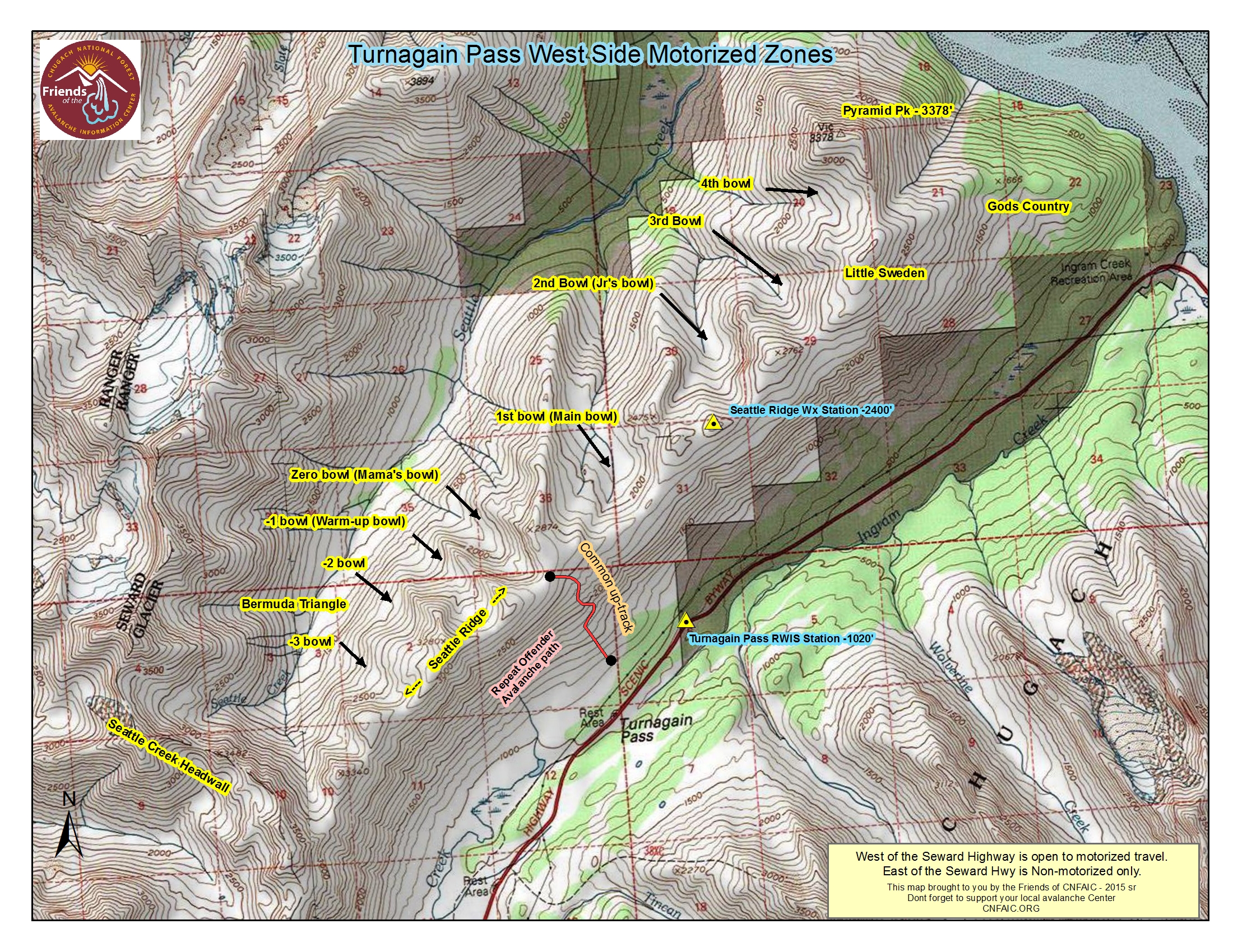
Today, Sunday December 13th, the Chugach National Forest has opened Turnagain Pass to motorized use. Scroll to the bottom of this page for more information on other riding areas in the Chugach National Forest.   If you head out, please ensure everyone in your group is carrying avalanche rescue gear and knows how to use it!  

CNFAIC is hosting a Free Avalanche Rescue Workshop on Sunday, December 20th at Turnagain Pass. This is a great opportunity to practice beacon searches, learn strategic shoveling techniques and meet local forecasters! This workshop is open to everyone and anyone, novices and experts. We encourage all user types to participate €“ snowmachiners, skiers, boarders, kicker-builders, etc €¦  

Thanks to our sponsors!
Sun, December 13th, 2015
Alpine
Above 2,500'
Considerable (3)
Avalanche risk
Treeline
1,000'-2,500'
Considerable (3)
Avalanche risk
Below Treeline
Below 1,000'
Moderate (2)
Avalanche risk
Alpine
Above 2,500'
Avalanche risk
Considerable (3)
Treeline
1,000'-2,500'
Avalanche risk
Considerable (3)
Below Treeline
Below 1,000'
Avalanche risk
Moderate (2)
Danger Scale:
No Rating (0)
Low (1)
Moderate (2)
Considerable (3)
High (4)
Extreme (5)
Avalanche Problem 1
  • Persistent Slabs
    Persistent Slabs
Persistent Slabs
Persistent Slab avalanches are the release of a cohesive layer of snow (a slab) in the middle to upper snowpack, when the bond to an underlying persistent weak layer breaks. Persistent layers include: surface hoar, depth hoar, near-surface facets, or faceted snow. Persistent weak layers can continue to produce avalanches for days, weeks or even months, making them especially dangerous and tricky. As additional snow and wind events build a thicker slab on top of the persistent weak layer, this avalanche problem may develop into a Deep Persistent Slab.
More info at Avalanche.org

A storm that lasted three days left an upwards of 20+” of new snow in the mid and upper elevations of Turnagain Pass. This storm favored the Northern side of Turnagain including Eddies, Tincan and Seattle Ridge. Strong sustained Northeast winds accompanied this storm with one reported avalanche on Tincan that likely occurred near the end of the storm. Little information exists in the Alpine elevations due to dangerous avalanche conditions and limited visibility.  

This new snow is sitting on top of various weak layers of old snow, which are resting on a uniform bed surface. Yesterday test pit results confirm this structure has potential to be reactive and propagate. If the right trigger were to collapse a weak layer it will likely cause a large avalanche. Traveling on or under large steep slopes should be avoided until the snowpack has more time to adjust.

If you are planning to participate in the first day of snowmachining for the season, don’t be deceived by drastically different snow conditions as you head North and start to gain elevation. Be aware of others and do not congregate underneath large open slopes like Repeat Offender on the Seattle Ridge up-track. The only way to manage this challenging avalanche problem is by minimizing your exposure to steep slopes and practicing safe travel rituals.

Early Season Sledding Reminders:

  • Check your partner’s beacon and equipment at the parking lot
  • Make sure you have a shovel and probe on your body
  • Be aware of early season hazards like drainages with open water
  • Minimize your impact in areas with thin snow coverage like ‘Rookie Hill’
Avalanche Problem 2
  • Wind Slabs
    Wind Slabs
Wind Slabs
Wind Slab avalanches are the release of a cohesive layer of snow (a slab) formed by the wind. Wind typically transports snow from the upwind sides of terrain features and deposits snow on the downwind side. Wind slabs are often smooth and rounded and sometimes sound hollow, and can range from soft to hard. Wind slabs that form over a persistent weak layer (surface hoar, depth hoar, or near-surface facets) may be termed Persistent Slabs or may develop into Persistent Slabs.
More info at Avalanche.org

Winds are expected to increase in the afternoon, and could be in the 30’s mph with gusts in the 40’s mph. There is a lot of snow available for transport and lots of potential to form new wind slabs. Luckily the timing is expected to be later in the day, but pay attention for drifting snow, shooting cracks, and wumpfing sounds – all Redflag warnings that the snow is not safe. 

Additional Concern
  • Announcement
    Announcement


THE NATIONAL WEATHER SERVICE IN ANCHORAGE HAS ISSUED A BLIZZARD
WARNING...WHICH IS IN EFFECT FROM 6 PM THIS EVENING TO 6 AM AKST
MONDAY.

* LOCATION...PORTAGE VALLEY AND TURNAGAIN ARM.

* SNOW...3 TO 6 INCHES.

* VISIBILITY...REDUCED TO LESS THAN ONE QUARTER MILE AT TIMES.

* WIND...EAST WIND 20 TO 30 MPH INCREASING TO 25 TO 40 MPH AFTER
         MIDNIGHT.

* TIMING...BLIZZARD CONDITIONS WILL START THIS EVENING AND BECOME
  MORE INTENSE AFTER MIDNIGHT. CONDITIONS ARE EXPECTED TO IMPROVE
  EARLY MONDAY MORNING.
Weather
Sun, December 13th, 2015

A storm ended yesterday morning leaving overcast conditions throughout the day. Temperatures started to fall into the mid to low 20’s F, and ridgetop winds were light from the Northeast. Overnight temps continued to drop into the mid teens F.

Today skies are expected to be sunny in the morning becoming cloudy by the afternoon. Temperatures will be in the 20F’s with ridgetop winds from the Northeast, 15-25 mph. Winds and snowfall are expected to intensify by early evening and  the National Weather Service has issued a Blizzard Warning starting at 6pm tonight.  

 A very large low has been deepening over the Bering Sea and is expected to move into Southcentral Alaska tonight and last through Monday morning.

PRECIPITATION 24-hour data (6am – 6am)

  Temp Avg (F) Snow (in) Water (in) Snow Depth (in)
Center Ridge (1880′) 21   0   0   36  
Summit Lake (1400′) 19   0   0   13  
Alyeska Mid (1700′) 23   trace   0.2    31.5

RIDGETOP 24-hour data (6am – 6am)

  Temp Avg (F) Wind Dir Wind Avg (mph) Wind Gust (mph)
Sunburst (3812′) 15   NE 4   11  
Seattle Ridge (2400′) 17   ~   ~   ~  
Observations
Recent Observations for Turnagain Pass
Date Region Location
05/22/23 Turnagain Avalanche: Tincan
05/12/23 Turnagain Avalanche: Tincan, Sunburst, Magnum, Cornbiscuit
05/07/23 Turnagain Observation: Tincan – Bear Tracks
05/05/23 Turnagain Observation: Seattle Ridge
05/02/23 Turnagain Observation: Cornbiscuit
05/02/23 Turnagain Observation: Seward Hwy Turnagain Pass
04/30/23 Turnagain Observation: Magnum
04/29/23 Turnagain Observation: Tincan
04/28/23 Turnagain Avalanche: Taylor Pass/Pastoral
04/28/23 Turnagain Avalanche: Tincan
Riding Areas
Updated Thu, June 01st, 2023

Status of riding areas across the Chugach NF is managed by the Glacier and Seward Ranger Districts, not avalanche center staff. Riding area information is posted as a public service to our users and updated based on snow depth and snow density to prevent resource damage at trailhead locations. Riding area questions contact: mailroom_r10_chugach@fs.fed.us

Area Status Weather & Riding Conditions
Glacier District
Johnson Pass
Closed
Closed May 15.
Placer River
Closed
Closed May 15.
Skookum Drainage
Closed
Will close to motorized use on April 1, 2023 per the National Forest Plan.
Turnagain Pass
Closed
Will close on June 1.
Twentymile
Closed
Scheduled closure May 1.
Seward District
Carter Lake
Closed
Scheduled closure May 1.
Lost Lake Trail
Closed
Scheduled closure May 1.
Primrose Trail
Closed
Scheduled closure May 1.
Resurrection Pass Trail
Closed
Closed to motorized use for the 2022/23 winter season per Forest Plan. Open next season.
Snug Harbor
Closed
Extended opening until May 15.
South Fork Snow River Corridor
Closed
Scheduled closure May 1.
Summit Lake
Closed
Scheduled closure May 1.

Subscribe to Turnagain Pass
Avalanche Forecast by Email

This is a general backcountry avalanche advisory issued for Turnagain Arm with Turnagain Pass as the core advisory area. This advisory does not apply to highways, railroads or operating ski areas.