Turnagain Pass Avalanche Forecast RSS

Archives
ARCHIVED FORECAST - All forecasts expire after 24 hours from the posting date/time.
Issued
Mon, December 14th, 2015 - 7:00AM
Expires
Tue, December 15th, 2015 - 7:00AM
Forecaster
Wendy Wagner
Avalanche risk The Bottom Line

Another round of snowfall with upwards of 6″ overnight and strong wind is keeping the avalanche danger at CONSIDERABLE in the upper elevation start zones. Expect wind slab avalanches around a foot thick to be easily triggered on wind loaded slopes. A MODERATE danger exists below 2,500′ for these same avalanches in areas the wind is affecting the snow. At all elevations, watch for loose snow avalanches on steep slopes.

Special Announcements

Join CNFAIC forecasters for a  Free Avalanche Rescue Workshop  on Sunday, December 20th  at Turnagain Pass!! This is a great opportunity to practice beacon searches, learn strategic shoveling techniques and more. This workshop is open to everyone and anyone, novices and experts. We will meet from 11:00-12:30 at the motorized parking lot. See you there!

Thanks to our sponsors!
Mon, December 14th, 2015
Alpine
Above 2,500'
Considerable (3)
Avalanche risk
Treeline
1,000'-2,500'
Moderate (2)
Avalanche risk
Below Treeline
Below 1,000'
Moderate (2)
Avalanche risk
Alpine
Above 2,500'
Avalanche risk
Considerable (3)
Treeline
1,000'-2,500'
Avalanche risk
Moderate (2)
Below Treeline
Below 1,000'
Avalanche risk
Moderate (2)
Danger Scale:
No Rating (0)
Low (1)
Moderate (2)
Considerable (3)
High (4)
Extreme (5)
Avalanche Problem 1
  • Storm Slabs
    Storm Slabs
Storm Slabs
Storm Slab avalanches are the release of a cohesive layer (a slab) of new snow that breaks within new snow or on the old snow surface. Storm-slabs typically last between a few hours and few days (following snowfall). Storm-slabs that form over a persistent weak layer (surface hoar, depth hoar, or near-surface facets) may be termed Persistent Slabs or may develop into Persistent Slabs.
More info at Avalanche.org

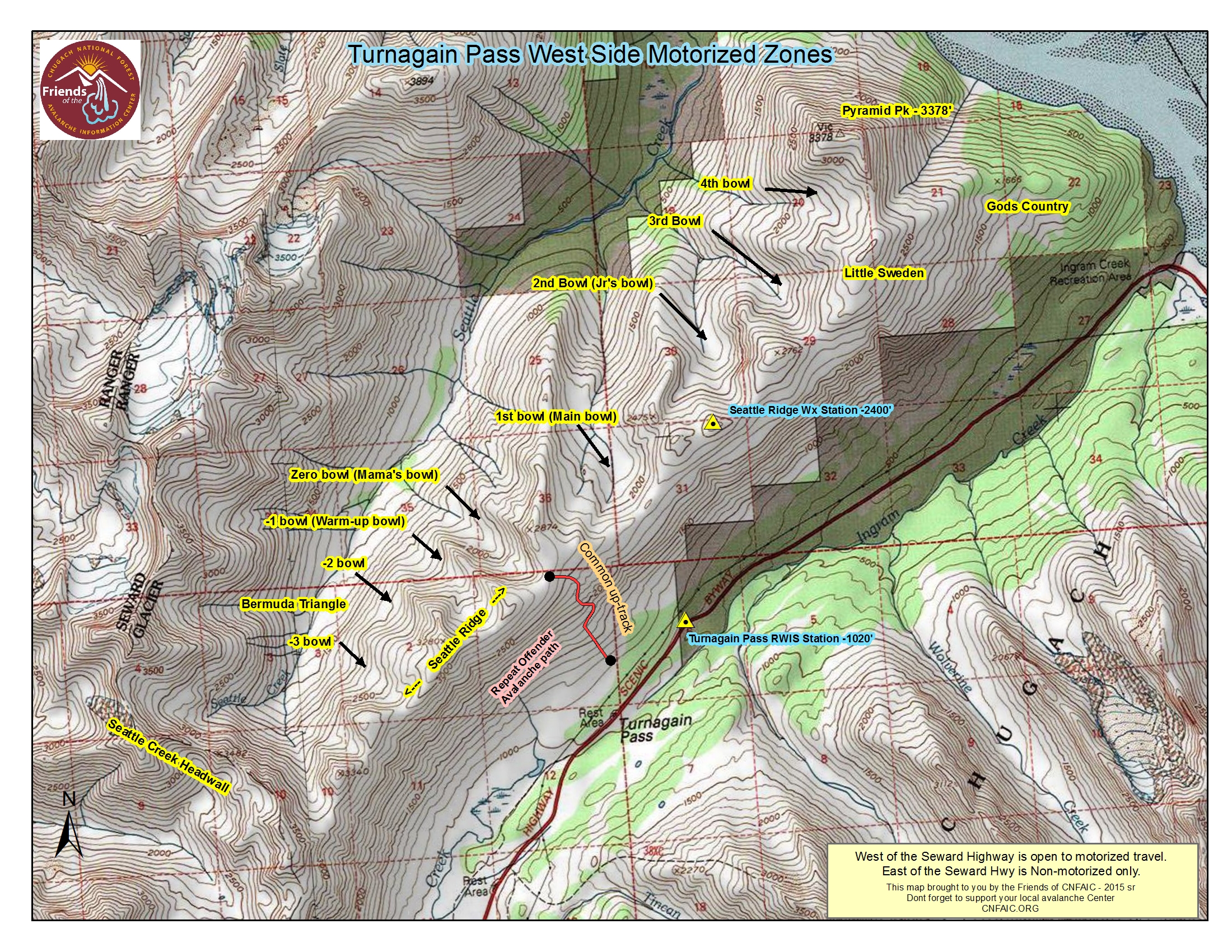
After a brief break in storms yesterday, another pulse of moisture added 5-6+” of new snow last night, with an additional 2-3″ expected today. It’s starting to look like winter up at the Pass! Yesterday also was the 1st time in over 18 months that enough snow covered the ground to allow the Chugach National Forest to open to motorized use. Many, many folks were out enjoying the day as well as testing the slope stability. After a good thumping by snowmachines, we only had one report of a sled triggered avalanche. This was remotely triggered in 2nd Bowl (Junior’s Bowl). If anyone has additional information regarding any other avalanche activity please send us a quick note HERE.

Avalanche conditions today will be mainly confined to storm snow issues. These are:

WIND SLABS: Strong winds blew from a generally East direction last night accompanying the snowfall. With the new snow plus plenty existing snow available for transport, watch for any slope that has been freshly wind loaded. These slabs are likely to be around a foot thick, but do have the potential to ‘step down’ into deeper layers and trigger a larger avalanche. Watch for cracks that shoot from your snowmachine/skis/board and areas with a smooth rounded surface texture – these are signs that a wind slab is present and could slide if the slope is steep enough.

SLUFFS: Sluffs on steep slopes should be expected within today’s light snow.

Again as Heather pointed out yesterday, the snowpack is dramatically thicker on the North end of the Turnagain Pass. With that said, the South side of the Pass is slowly filling in. Photo below is from Mike Records from the Silver Tip area:


The motorized lot on opening day 2015/16.

Avalanche Problem 2
  • Persistent Slabs
    Persistent Slabs
Persistent Slabs
Persistent Slab avalanches are the release of a cohesive layer of snow (a slab) in the middle to upper snowpack, when the bond to an underlying persistent weak layer breaks. Persistent layers include: surface hoar, depth hoar, near-surface facets, or faceted snow. Persistent weak layers can continue to produce avalanches for days, weeks or even months, making them especially dangerous and tricky. As additional snow and wind events build a thicker slab on top of the persistent weak layer, this avalanche problem may develop into a Deep Persistent Slab.
More info at Avalanche.org

Under the 16-30″ of storm snow from the past 5 days sits both a layer of Buried Surface Hoar (BSH) and a layer of Near Surface Facets (NSF). Although one of these layers may be the culprit for the avalanche yesterday, we cannot say that for certain since we were not able to investigate. We do know stability tests are showing mixed results, with the general theme of no reactivity. Although it is becoming unlikely to trigger a large avalanche breaking 2+’ down, it is not out of the question and something to keep in the back of our heads.

A look at a layer of BSH at 3,100′ on a SW aspect – you can see the ‘thin gray’ line in the middle of the snow (Photo credit Andy Moderow, report HERE). This layer is not found everywhere and since it can be a problem layer for avalanche activity, we are tracking it.
 

Weather
Mon, December 14th, 2015

Yesterday afternoon skies clouded over, Easterly winds picked up and snow began to fall as a quick moving system rolled through. Between 5-6″ of snow fell overnight with Easterly winds averaging in the 30’s and 40’s mph. Temperatures have climbed slightly and are sitting near 20F on the ridgetops and near 30F at sea level.

Today, intermittent snow showers will linger with mostly cloudy skies. We may pick up an additional 2-3″ in favored areas. Winds have decreased this morning and will be in the 5-15mph range from the East.

Tuesday night through Thursday another round of snowfall is expected as a strong low-pressure moves into the gulf.

PRECIPITATION 24-hour data (6am – 6am)

  Temp Avg (F) Snow (in) Water (in) Snow Depth (in)
Center Ridge (1880′) 23   5   0.4    41  
Summit Lake (1400′) 21   2   0.2    14  
Alyeska Mid (1700′) 24   6   0.42    35

RIDGETOP 24-hour data (6am – 6am)

  Temp Avg (F) Wind Dir Wind Avg (mph) Wind Gust (mph)
Sunburst (3812′)  17 NE   32   66  
Seattle Ridge (2400′) 19   N/A   N/A   N/A  
Observations
Recent Observations for Turnagain Pass
Date Region Location
05/22/23 Turnagain Avalanche: Tincan
05/12/23 Turnagain Avalanche: Tincan, Sunburst, Magnum, Cornbiscuit
05/07/23 Turnagain Observation: Tincan – Bear Tracks
05/05/23 Turnagain Observation: Seattle Ridge
05/02/23 Turnagain Observation: Cornbiscuit
05/02/23 Turnagain Observation: Seward Hwy Turnagain Pass
04/30/23 Turnagain Observation: Magnum
04/29/23 Turnagain Observation: Tincan
04/28/23 Turnagain Avalanche: Taylor Pass/Pastoral
04/28/23 Turnagain Avalanche: Tincan
Riding Areas
Updated Sat, September 23rd, 2023

Status of riding areas across the Chugach NF is managed by the Glacier and Seward Ranger Districts, not avalanche center staff. Riding area information is posted as a public service to our users and updated based on snow depth and snow density to prevent resource damage at trailhead locations. Riding area questions contact: mailroom_r10_chugach@fs.fed.us

Area Status Weather & Riding Conditions
Glacier District
Johnson Pass
Closed
Scheduled opening per Chugach National Forest plan December 1. Subject to adequate snow cover.
Placer River
Closed
Scheduled opening per Chugach National Forest plan December 1. Subject to adequate snow cover.
Skookum Drainage
Closed
Scheduled opening per Chugach National Forest plan December 1. Subject to adequate snow cover.
Turnagain Pass
Closed
Scheduled opening on the Wednesday before Thanksgiving per Chugach National Forest plan. Subject to adequate snow cover.
Twentymile
Closed
Scheduled opening per Chugach National Forest plan December 1. Subject to adequate snow cover.
Seward District
Carter Lake
Closed
Scheduled opening per Chugach National Forest plan December 1. Subject to adequate snow cover.
Lost Lake Trail
Closed
Scheduled opening per Chugach National Forest plan December 1. Subject to adequate snow cover.
Primrose Trail
Closed
Scheduled opening per Chugach National Forest plan December 1. Subject to adequate snow cover.
Resurrection Pass Trail
Closed
Scheduled opening per Chugach National Forest plan December 1. Subject to adequate snow cover.
Snug Harbor
Closed
Scheduled opening per Chugach National Forest plan December 1. Subject to adequate snow cover.
South Fork Snow River Corridor
Closed
Scheduled opening per Chugach National Forest plan December 1. Subject to adequate snow cover.
Summit Lake
Closed
Scheduled opening per Chugach National Forest plan December 1. Subject to adequate snow cover.

Subscribe to Turnagain Pass
Avalanche Forecast by Email

This is a general backcountry avalanche advisory issued for Turnagain Arm with Turnagain Pass as the core advisory area. This advisory does not apply to highways, railroads or operating ski areas.