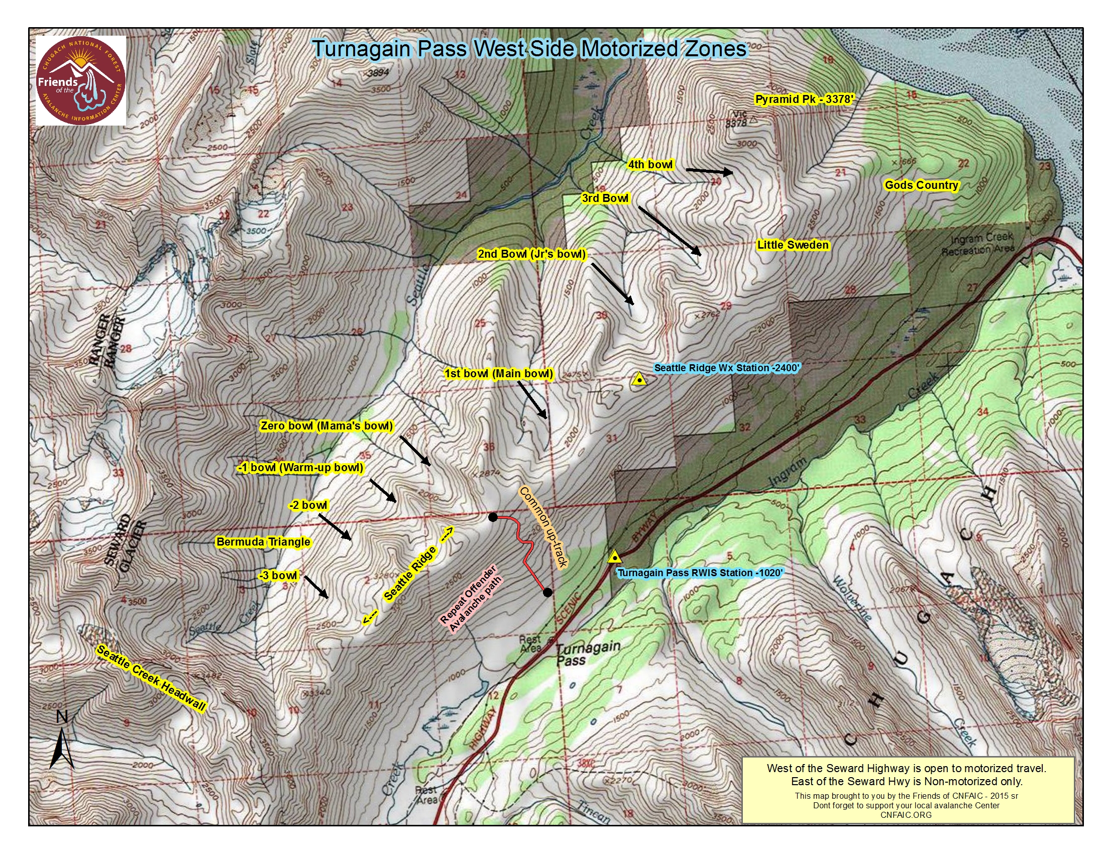
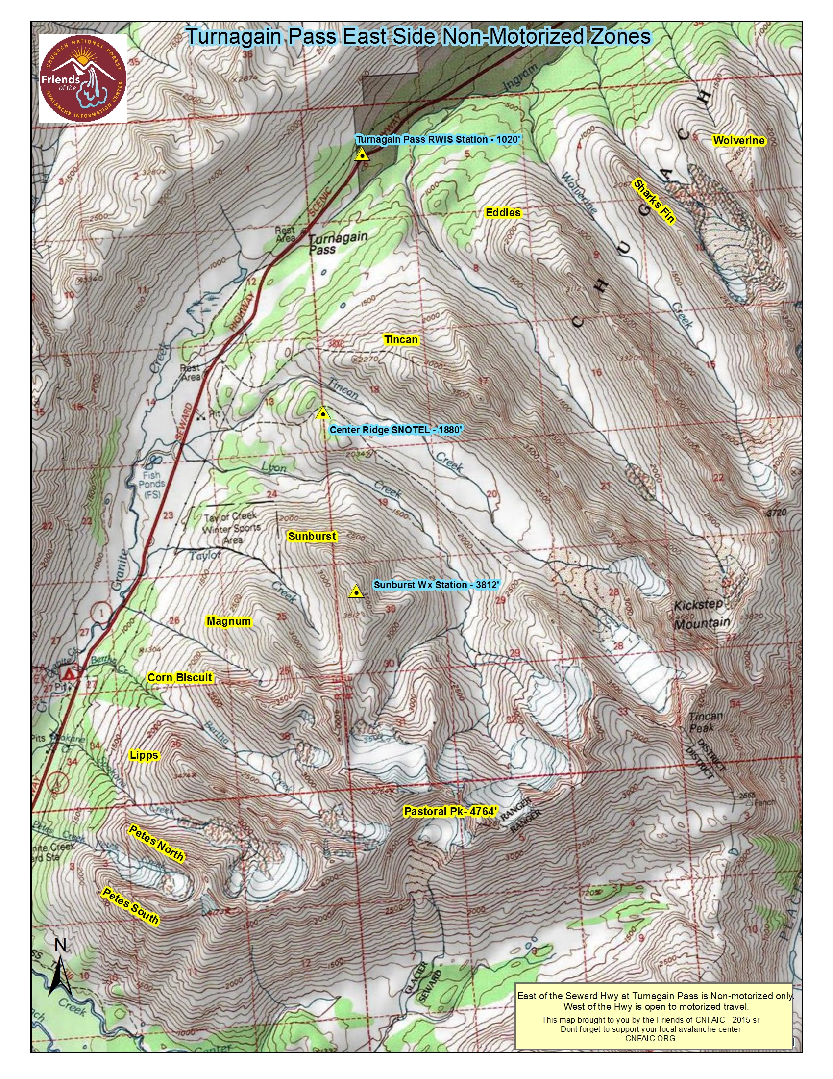
Turnagain Pass RSS

Archives
ARCHIVED - Forecasts expire after 24 hours.
Issued
Sat, December 12th, 2015 - 7:00AM
Expires
Sun, December 13th, 2015 - 7:00AM
Forecaster
Graham Predeger
Avalanche risk The Bottom Line

CONSIDERABLE avalanche danger exists today above treeline.   An average of 12 to 24 inches of new snow since Thursday combined with moderate to strong winds in the alpine have created dangerous avalanche conditions.   Human-triggered avalanches 2-4′ deep will be likely in upper elevation, leeward terrain where fresh wind slabs sit on top of weak, faceted snow.  A rule of thumb for today is that you can expect the avalanche hazard to increase with elevation.

At and below treeline there is a MODERATE danger.  The new snow is showing signs of good bonding where it’s been unaffected by wind, though keep in mind we are still within 24 hours of the end of the storm and heightened avalanche conditions do exist on specific terrain features.

Special Announcements

The Chugach National Forest will open Turnagain Pass to motorized use TOMORROW, Sunday December 13th.   Scroll to the bottom of this page for more information on other riding areas in the Chugach National Forest.   If you head out, please ensure everyone in your group is carrying avalanche rescue gear and knows how to use it!  

Interested in how people make decisions in avalanche terrain?  Montana State University’s Snow and Avalanche Laboratory, is leading a project they hope will bring about a better understanding of those risk-taking decisions with a smartphone app.   Click here for more info, to participate and submit YOUR Alaska data to this international research project.  Snowmachiners, click here.

Sat, December 12th, 2015
Alpine
Above 2,500'
3 - Considerable
Avalanche risk
Treeline
1,000'-2,500'
2 - Moderate
Avalanche risk
Below Treeline
Below 1,000'
2 - Moderate
Avalanche risk
0 - No Rating
1 - Low
2 - Moderate
3 - Considerable
4 - High
5 - Extreme
Avalanche risk Avalanche risk Avalanche risk Avalanche risk Avalanche risk
Travel Advice Generally safe avalanche conditions. Watch for unstable snow on isolated terrain features. Heightened avalanche conditions on specific terrain features. Evaluate snow and terrain carefully; identify features of concern. Dangerous avalanche conditions. Careful snowpack evaluation, cautious route-finding, and conservative decision-making essential. Very dangerous avalanche conditions. Travel in avalanche terrain not recommended. Extraordinarily dangerous avalanche conditions. Avoid all avalanche terrain.
Likelihood of Avalanches Natural and human-triggered avalanches unlikely. Natural avalanches unlikely; human-triggered avalanches possible. Natural avalanches possible; human-triggered avalanches likely. Natural avalanches likely; human-triggered avalanches very likely. Natural and human-triggered avalanches certain.
Avalanche Size and Distribution Small avalanches in isolated areas or extreme terrain. Small avalanches in specific areas; or large avalanches in isolated areas. Small avalanches in many areas; or large avalanches in specific areas; or very large avalanches in isolated areas. Large avalanches in many areas; or very large avalanches in specific areas. Very large avalanches in many areas.
Avalanche Problem 1
  • Wind Slabs
    Wind Slabs
Wind Slabs
Wind Slab avalanches are the release of a cohesive layer of snow (a slab) formed by the wind. Wind typically transports snow from the upwind sides of terrain features and deposits snow on the downwind side. Wind slabs are often smooth and rounded and sometimes sound hollow, and can range from soft to hard. Wind slabs that form over a persistent weak layer (surface hoar, depth hoar, or near-surface facets) may be termed Persistent Slabs or may develop into Persistent Slabs.
More info at Avalanche.org

New snow in quick storm bursts over the last 3-days have deposited from 4 to 24 inches of snow onto a layer of weak facets above 1,000’.  It appears that the northern section of Turnagain pass (Eddies, Tin Can, Main bowl and north) have seen the most snow with reports of 20”+ above 2200’.  Add to this winds in the 30’s and gusts in the 40’s and 50’s mph on Sunburst yesterday and we’ve got a recipe for tender windslabs in the 2-4’ range in the Alpine.  This problem is likely to be exacerbated the higher in elevation you go.  Make no mistake; this is not a ‘manageable’ avalanche problem for a skier.  Today would be a good day to seek out and jump on small (no consequence) test slopes keeping a keen eye for the classic red flags (recent avalanches, shooting cracks or whumphing).  If seen, recognize these as a sign to dial your terrain choices way back to seek out lower elevation, lower angle terrain.

With the predominant wind direction from the east and northeast, you can expect west and southwest slopes to be the most suspect for wind slab formation.  Unfortunately this includes much of the popular terrain in the Turnagain zone such as Eddie’s, Tin Can common bowl, CFR, Sunburst, etc.

Avalanche Problem 2
  • Persistent Slabs
    Persistent Slabs
Persistent Slabs
Persistent Slab avalanches are the release of a cohesive layer of snow (a slab) in the middle to upper snowpack, when the bond to an underlying persistent weak layer breaks. Persistent layers include: surface hoar, depth hoar, near-surface facets, or faceted snow. Persistent weak layers can continue to produce avalanches for days, weeks or even months, making them especially dangerous and tricky. As additional snow and wind events build a thicker slab on top of the persistent weak layer, this avalanche problem may develop into a Deep Persistent Slab.
More info at Avalanche.org

We can’t forget about the weak snow this latest series of storms now rests on.  Cold temps and clear skies last weekend produced a substantial and widespread layer of weak, faceted snow that now sits below 1-2’ of storm snow.  Yesterday’s storm prevented most people from getting into the alpine but observations at treeline show this interface to be bonding well.  I suspect with increased elevation (above 2500’), the weak layer/ storm snow interface could prove troublesome as these layers have a tendency to heal slower in colder temperatures.  There was a report of “a lot of localized whumphing and debris that only looked a day or so old” from Eddies yesterday, though we don’t have info in terms of aspect or elevation but it is suspect that the old snow/ new snow interface may be the culprit.

Again, look for red flags and scale back terrain choices if necessary.  Continue to practice safe travel techniques (ski one at a time and plan for your escape route/ safe zone) and be mindful of other groups in your vicinity while on slope or skin track.

Alders are feeling the weight of our most recent storms on the approach to Sunburst yesterday.

Weather
Sat, December 12th, 2015

Yesterday we saw a short period of intense snowfall over eastern Turnagain arm with the northern side of Turnagain pass again being favored.   Areas such as Girdwood and Portage also saw snow to sea level.   Winds were predominantly from the east in the 20-30mph range, gusting into the 50’s on Sunburst.  

Today, the low pressure over southcentral breaks down and we may see a few lingering flurries but generally a clearing trend through tomorrow.   Temps will be in the mid to high 20’s F at 1000′ and low 20’s at ridgetops with light winds from the SE in the 5-15mph range.   The next front moves into our area late Sunday night/ Monday and brings with it another chance for unsettled weather during the work week.

For the weather geeks out there, take a look at this powerful Bering Sea storm currently impacting the western Aleutian Islands.   Looks like it’ll steer clear of our region but the NWS is saying €œThis storm will put itself in the top echelon of intense cyclones to impact the Bering Sea….” with a central pressure expected to bottom out in the 920’s.

PRECIPITATION 24-hour data (6am – 6am)

  Temp Avg (F) Snow (in) Water (in) Snow Depth (in)
Center Ridge (1880′) 27 4-6   .4   40  
Summit Lake (1400′)  26  1  .1 13  
Alyeska Mid (1700′)  28  5  .5 30  

RIDGETOP 24-hour data (6am – 6am)

  Temp Avg (F) Wind Dir Wind Avg (mph) Wind Gust (mph)
Sunburst (3812′)  20 NE   22    53
Seattle Ridge (2400′)  23 N/A   N/A   N/A  
Observations
Recent Observations for Turnagain Pass
Date Region Location
03/27/24 Turnagain Observation: Tincan Trees
03/26/24 Turnagain Observation: Cornbiscuit
03/25/24 Turnagain Observation: Tincan
03/22/24 Turnagain Avalanche: Magnum Northwest Aspect
03/21/24 Turnagain Observation: Sunburst
03/21/24 Turnagain Observation: Tincan Proper North Aspect
03/20/24 Turnagain Avalanche: Seattle Creek Drainage
03/19/24 Turnagain Observation: Tincan CFR
03/18/24 Turnagain Avalanche: Tincan – Eddies – Seattle Ridge
03/18/24 Turnagain Observation: Tincan
Riding Areas

The riding areas page has moved. Please click here & update your bookmarks.


Subscribe to Turnagain Pass
Avalanche Forecast by Email

This is a general backcountry avalanche advisory issued for Turnagain Arm with Turnagain Pass as the core advisory area. This advisory does not apply to highways, railroads or operating ski areas.