Turnagain Pass
|
![]() ![]() |
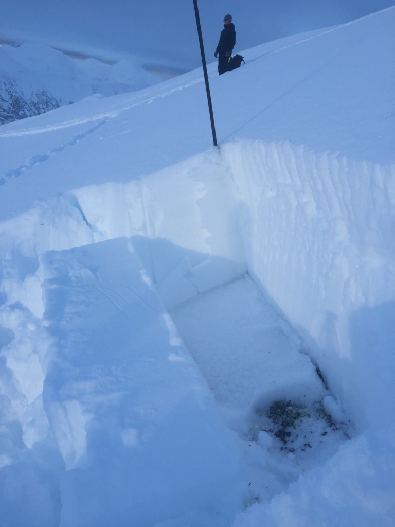
A generally LOW avalanche danger exists in the mountains surrounding Turnagain Pass. Triggering an avalanche is unlikely but not impossible. The most suspect slopes are in steep terrain at the high elevations where someone just might be able to break off a slab 1-2′ thick. LOW danger does not mean no danger. Good travel habits, such as exposing one person at a time, watching your partners, grouping up in safe zones and having an escape route planned are, as always, key ways to minimize risk.
*If venturing into the ‘periphery’ forecast zones, such as Girdwood Valley, Silvertip and Summit Lake areas, more caution is advised due to limited information about the snowpack in these areas.
Fireside Chat #2 – Avalanche Rescue – Dec 10th!! Join CNFAIC forecaster Heather Thamm Thursday night from 6:30-8:00pm at the Alaska Avalanche School for a presentation on “Rescue Fundamentals”. A successful rescue of a buried individual can hinge on even a little bit of knowledge, we hope to see you there!
![]() |
![]() |
![]() |
![]() |
![]() |
|
Travel Advice | Generally safe avalanche conditions. Watch for unstable snow on isolated terrain features. | Heightened avalanche conditions on specific terrain features. Evaluate snow and terrain carefully; identify features of concern. | Dangerous avalanche conditions. Careful snowpack evaluation, cautious route-finding, and conservative decision-making essential. | Very dangerous avalanche conditions. Travel in avalanche terrain not recommended. | Extraordinarily dangerous avalanche conditions. Avoid all avalanche terrain. |
Likelihood of Avalanches | Natural and human-triggered avalanches unlikely. | Natural avalanches unlikely; human-triggered avalanches possible. | Natural avalanches possible; human-triggered avalanches likely. | Natural avalanches likely; human-triggered avalanches very likely. | Natural and human-triggered avalanches certain. |
Avalanche Size and Distribution | Small avalanches in isolated areas or extreme terrain. | Small avalanches in specific areas; or large avalanches in isolated areas. | Small avalanches in many areas; or large avalanches in specific areas; or very large avalanches in isolated areas. | Large avalanches in many areas; or very large avalanches in specific areas. | Very large avalanches in many areas. |
The Turnagain Pass area saw another sunny day with moderate temperatures and no reports of significant instability. An observation from Saturday illustrates the potential for small slabs in steep areas, a typical LOW danger concern.
As the weather pattern shifts today, bringing showery weather and stronger winds, taking inventory of the surface characteristics is critical to get a picture of what may happen in the days to come as the conditions change. We know that any new precipitation will land on a combination of weak faceted snow and surface hoar that have formed over the past days during the cold clear weather. Underneath these persistent grain types, that could become persistent weak layers, is either a stout rain crust (up to around 2500′) or dense snow that could act as a future bed surface. A forecaster observation from Sunday speaks to what to keep in mind when thinking about near surface facets and surface hoar together.
***If winds increase today and snow is moved around pay attention to areas that are leeward and may develop small pockets of wind slab on the weak snow/bed surface combination.
Remember the surface conditions (facets and surface hoar to ridge tops) that may get buried this week.
.
We are continuing to track the layer of basal facets from the cold period in early November. For the most part these have been non-reactive. With the potential for additional load in the coming week we will be interested to see if this changes.
Today’s weather is forecasted to be a mixture of showery weather in the morning and then mostly to partly cloudy in the afternoon. There is the possibility of snow with up to an inch of accumulation. Temperatures will be in the upper 20Fs to mid 30Fs. Wind will be N-NE, 10-20 mph with gusts in the 30s.
Tomorrow the unsettled weather will continue as the low in the Gulf spins moisture into the region. Cloudy skies, snow showers and warmer temperatures are on tap for the week as the overall pattern shifts.
PRECIPITATION 24-hour data (6am – 6am)
Temp Avg (F) | Snow (in) | Water (in) | Snow Depth (in) | |
Center Ridge (1880′) | 22 | 0 | 0 | 23 |
Summit Lake (1400′) | 15 | 0 | 0 | 11 |
Alyeska Mid (1700′) | 25 | 0 | 0 | 19 |
Temp Avg (F) | Wind Dir | Wind Avg (mph) | Wind Gust (mph) | |
Sunburst (3812′) | 22 | NE | 18 | 38 |
Seattle Ridge (2400′) | 22 | SE | 15 | 38 |
Date | Region | Location | Observer |
---|---|---|---|
10/27/24 | Turnagain | Observation: Tincan | Michael Kerst |
10/21/24 | Turnagain | Observation: Turnagain Pass Road Observation | Trevor Clayton |
10/19/24 | Turnagain | Observation: Tincan – Below Todds Run | Andy Moderow |
10/18/24 | Turnagain | Observation: Taylor Pass | Eli Neuffer |
10/15/24 | Turnagain | Observation: Tincan Common | John Sykes Forecaster |
10/14/24 | Turnagain | Avalanche: Tincan | CNFAC Staff |
05/13/24 | Turnagain | Observation: Eddie’s, Sunburst, Seattle, Cornbiscuit, Pete’s South | H Thamm |
05/13/24 | Turnagain | Observation: Turnagain Pass non-motorized side | Amy Holman |
05/12/24 | Turnagain | Observation: Warm up Bowl | Tony Naciuk |
05/07/24 | Turnagain | Observation: Turnagain Pass Wet Slabs | A S |
The riding areas page has moved. Please click here & update your bookmarks.
Subscribe to Turnagain Pass
Avalanche Forecast by Email