The avalanche danger is CONSIDERABLE above 1000′ today. New snow and strong winds have created dangerous avalanche conditions. Natural avalanches are possible and human triggered storm and wind slabs, 1-3′ deep are likely. Between 1300′-2500′ there is also chance of triggering a deep slab avalanche breaking 3-5′ deep on a buried weak layer associated with a crust. Cautious route-finding and conservative decision-making are essential. Look for signs of instability and choose terrain wisely.
Below 1000′ the avalanche danger is MODERATE. Human triggered small wet loose avalanches are possible.
SUMMIT LAKE: The snowpack in the Summit Lake area is thinner and weaker. In addition to the newly formed wind slabs, there is still a chance of triggering a slab that breaks in a buried weak layer mid-pack or near the ground.
Mon, December 28th, 2020
Alpine
Above 2,500'
3 - Considerable
Treeline
1,000'-2,500'
3 - Considerable
Below Treeline
Below 1,000'
2 - Moderate
0 - No Rating
1 - Low
2 - Moderate
3 - Considerable
4 - High
5 - Extreme
Travel Advice
Generally safe avalanche conditions. Watch for unstable snow on isolated terrain features.
Heightened avalanche conditions on specific terrain features. Evaluate snow and terrain carefully; identify features of concern.
Natural avalanches likely; human-triggered avalanches very likely.
Natural and human-triggered avalanches certain.
Avalanche Size and Distribution
Small avalanches in isolated areas or extreme terrain.
Small avalanches in specific areas; or large avalanches in isolated areas.
Small avalanches in many areas; or large avalanches in specific areas; or very large avalanches in isolated areas.
Large avalanches in many areas; or very large avalanches in specific areas.
Very large avalanches in many areas.
Avalanche Problem 1
Storm Slabs
Certain
Very Likely
Likely
Possible
Unlikely
Likelihood
Historic (D4-5)
Very Large (D3)
Large (D2)
Small (D1)
Size
Storm Slabs
Storm Slab avalanches are the release of a cohesive layer (a slab) of new snow that breaks within new snow or on the old snow surface. Storm-slabs typically last between a few hours and few days (following snowfall). Storm-slabs that form over a persistent weak layer (surface hoar, depth hoar, or near-surface facets) may be termed Persistent Slabs or may develop into Persistent Slabs.
Likelihood of Avalanches
Terms such as "unlikely", "likely", and "certain" are used to define the scale, with the chance of triggering or observing
avalanches increasing as we move up the scale. For our purposes, "Unlikely" means that few avalanches could be triggered in avalanche terrain and
natural avalanches are not expected. "Certain" means that humans will be able to trigger avalanches on many slopes, and natural avalanches are expected.
Size of Avalanches
Avalanche size is defined by the largest potential avalanche, or expected range of sizes related to the problem in question.
Assigned size is a qualitative estimate based on the destructive classification system and requires specialists to estimate the harm avalanches may cause to
hypothetical objects located in the avalanche track (AAA 2016, CAA 2014). Under this schema, "Small" avalanches are not large enough to bury humans and are
relatively harmless unless they carry people over cliffs or through trees or rocks. Moving up the scale, avalanches become "Large" enough to bury, injure,
or kill people. "Very Large" avalanches may bury or destroy vehicles or houses, and "Historic" avalanches are massive events capable of altering the landscape.
With around a foot of new snow and strong winds in the last 24 hours, we have our usual buffet of storm related avalanche issues today. Caution is advised. Human triggered avalanches are likely and natural avalanches are possible as easterly winds are forecast to stay elevated through the day blowing 15-25 mph with gusts into the 30s and 40s. Temperatures rose during the storm, starting with snow to sea level which then transitioned to rain in the evening. Rain/snow line was forecast to be around 500′ overnight and is expected to rise to 1400′ today.
This storm was ‘upside down’ with warm snow falling on colder snow. Watch for storm slabs on steep slopes in wind protected terrain. In wind exposed terrain expect slabs to be even more developed and touchy. Yesterday observers across the area reported developing wind slabs as the day progressed. East winds built throughout the day and peaked around midnight with gusts on Sunburst at 86 mph and 70 mph on Maxs. Triggering a wind slab 1-3′ deep is likely today on steep slopes or gullies with fresh wind deposited snow.
Look for signs of instability and wind effect:
Recent avalanches? There could have been some natural wind slabs overnight.
Cracking in the snow around your skis, board or machine.
Stiff snow over softer snow and wind pillows or drifts.
Cornices: As always, watch for cornices and give them a wide berth. New snow and wind increase the likelihood that these will break.
Loose snow avalanches (sluffs): In steep terrain protected from the wind watch for sluffing in the new snow that has not formed a slab. In steep terrain that is below 1000′ where it rained, there is a chance of triggering small wet loose avalanches in the saturated snow.
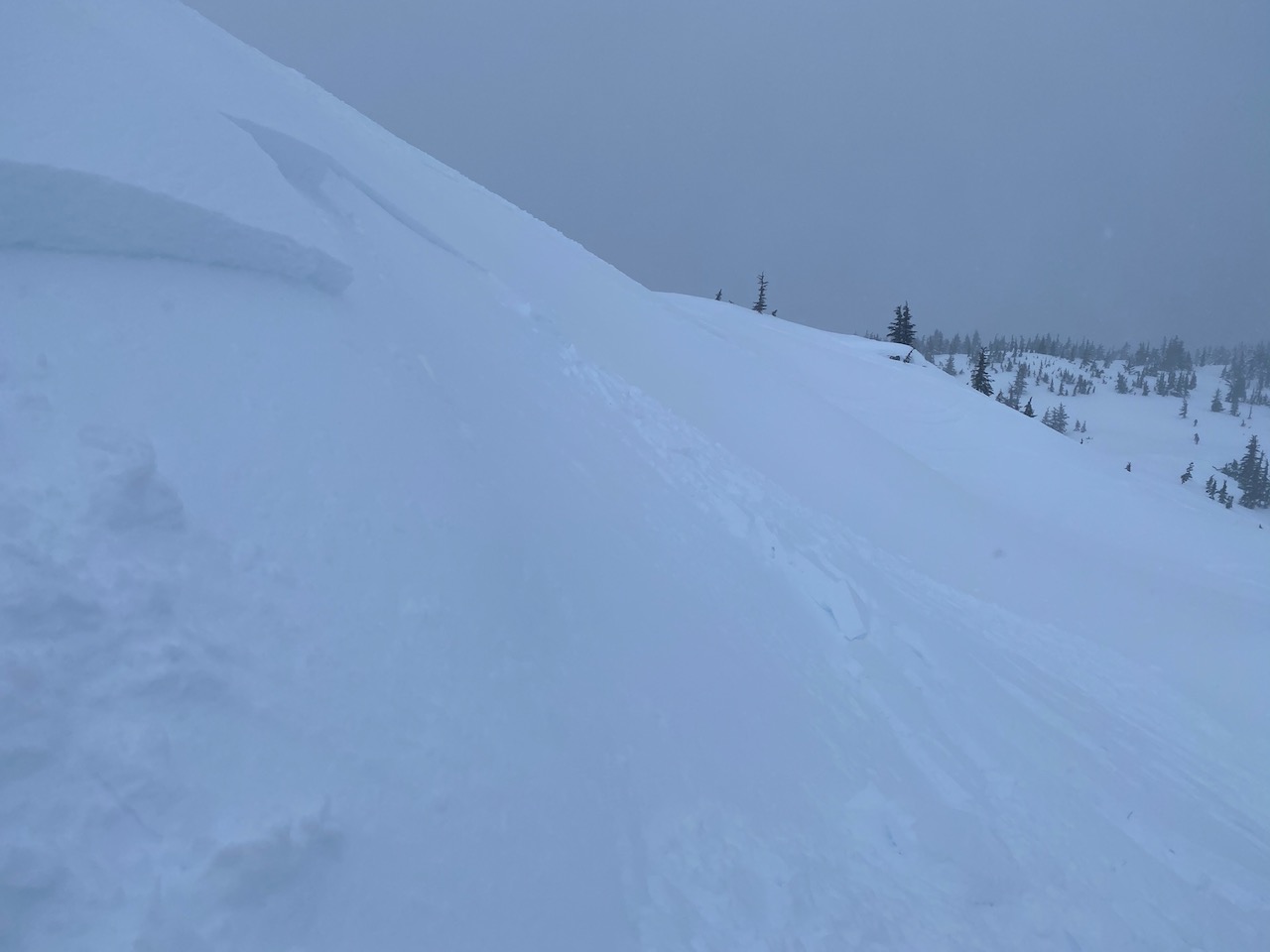
Small skier triggered wind slab on Notch Mountain, 12.27.20. Photo: George Creighton
Avalanche Problem 2
Deep Persistent Slabs
Certain
Very Likely
Likely
Possible
Unlikely
Likelihood
Historic (D4-5)
Very Large (D3)
Large (D2)
Small (D1)
Size
Deep Persistent Slabs
Deep Persistent Slab avalanches are the release of a thick cohesive layer of hard snow (a slab), when the bond breaks between the slab and an underlying persistent weak layer deep in the snowpack. The most common persistent weak layers involved in deep, persistent slabs are depth hoar or facets surrounding a deeply buried crust. Deep Persistent Slabs are typically hard to trigger, are very destructive and dangerous due to the large mass of snow involved, and can persist for months once developed. They are often triggered from areas where the snow is shallow and weak, and are particularly difficult to forecast for and manage.
Likelihood of Avalanches
Terms such as "unlikely", "likely", and "certain" are used to define the scale, with the chance of triggering or observing
avalanches increasing as we move up the scale. For our purposes, "Unlikely" means that few avalanches could be triggered in avalanche terrain and
natural avalanches are not expected. "Certain" means that humans will be able to trigger avalanches on many slopes, and natural avalanches are expected.
Size of Avalanches
Avalanche size is defined by the largest potential avalanche, or expected range of sizes related to the problem in question.
Assigned size is a qualitative estimate based on the destructive classification system and requires specialists to estimate the harm avalanches may cause to
hypothetical objects located in the avalanche track (AAA 2016, CAA 2014). Under this schema, "Small" avalanches are not large enough to bury humans and are
relatively harmless unless they carry people over cliffs or through trees or rocks. Moving up the scale, avalanches become "Large" enough to bury, injure,
or kill people. "Very Large" avalanches may bury or destroy vehicles or houses, and "Historic" avalanches are massive events capable of altering the landscape.
We have been tracking the crust that was formed on 12/1, after the rain level made it up to 2500’. At this point, the 12/1 crust is buried about 3-5′ deep. Avalanche mitigation with explosives continues to produce very large avalanches failing at this layer, initiated around 2500′. We have not seen human triggered avalanches or recent natural avalanches on this layer. However, we have noticed some faceting in the middle of the crust, which has been showing mixed results in stability tests. Saturday, a group of skiers in Pete’s North reported a large collapse in this layer while skinning up through the trees. Triggering an avalanche on this layer is unlikely but could have bad consequences. Signs of instability will not likely be present and stability tests could give unreliable data. Steep unsupported slopes in the 1300′-2500′ elevation range should be considered suspect and there may be multiple tracks on the slope before it fails.
The Summit Lake region to the south of our forecast area has a thinner snowpack with faceted snow at the ground that is a concern above 2500′. This area also has the December 1st crust/facet combo below 2500′. Both these weak layers are worth keeping in mind before trying to push into bigger terrain in the Summit Lake area.
Weather
Mon, December 28th, 2020
Yesterday: Skies were cloudy and snow fell throughout the day and overnight. Temperatures were in the mid 20°Fs to mid 30°Fs and increased during the day and overnight. Rain/snow line rose to around 500′ overnight. Winds were easterly and ramped up starting off blowing in the teens and 20s with gusts into the 30s and peaking around midnight blowing sustained 30-60 mph.
Today: Skies will remain cloudy and rain and snow showers will continue with 0.2″ of water/1-5″ of snow. Rain/snow line is forecast to rise to 1400′ and then drop to around 1000′ by the evening . Temperatures will be in the high 20°Fs to high 30°Fs depending on elevation and then trend to the 20°Fs and low 30°Fs overnight. East winds eased off early this morning from the overnight peak but will remain elevated today and tonight, blowing 15-25 mph gusting into the 30s and 40s.
Tomorrow: Cloudy skies will continue with rain and showers. Temperatures will be in the high 30°Fs at sea level and in the mid 20°Fs at ridgetops. East winds will blow 15 -25 mph decreasing in the afternoon. Clouds and snow showers look to continue into Wednesday and then skies start to clear off to usher in the new year.
This is a general backcountry avalanche advisory issued for Turnagain Arm with Turnagain Pass as the core advisory area.
This advisory does not apply to highways, railroads or operating ski areas.