Turnagain Pass RSS

Archives
ARCHIVED - Forecasts expire after 24 hours.
Issued
Tue, December 29th, 2020 - 7:00AM
Expires
Wed, December 30th, 2020 - 7:00AM
Forecaster
Andrew Schauer
Avalanche risk The Bottom Line

Today’s avalanche danger is MODERATE above 1000′, where it will be possible to trigger a wind slab avalanche 1-2’ deep. Between 1300-2500’, there is also a small chance of triggering a deeper avalanche on a weak layer buried 3-5’ deep, near a crust that formed in the beginning of the month. We will need to carefully assess the snowpack for these two issues today, and adjust our terrain use accordingly. The avalanche danger is LOW at elevations below 1000′.

Special Announcements
  • We have pushed our next Forecaster Chat to Jan. 16. Be sure to tune in as we talk snow and announce the winners from the Friends of the CNFAIC member gear giveaway!
Tue, December 29th, 2020
Alpine
Above 2,500'
2 - Moderate
Avalanche risk
Treeline
1,000'-2,500'
2 - Moderate
Avalanche risk
Below Treeline
Below 1,000'
1 - Low
Avalanche risk
0 - No Rating
1 - Low
2 - Moderate
3 - Considerable
4 - High
5 - Extreme
Avalanche risk Avalanche risk Avalanche risk Avalanche risk Avalanche risk
Travel Advice Generally safe avalanche conditions. Watch for unstable snow on isolated terrain features. Heightened avalanche conditions on specific terrain features. Evaluate snow and terrain carefully; identify features of concern. Dangerous avalanche conditions. Careful snowpack evaluation, cautious route-finding, and conservative decision-making essential. Very dangerous avalanche conditions. Travel in avalanche terrain not recommended. Extraordinarily dangerous avalanche conditions. Avoid all avalanche terrain.
Likelihood of Avalanches Natural and human-triggered avalanches unlikely. Natural avalanches unlikely; human-triggered avalanches possible. Natural avalanches possible; human-triggered avalanches likely. Natural avalanches likely; human-triggered avalanches very likely. Natural and human-triggered avalanches certain.
Avalanche Size and Distribution Small avalanches in isolated areas or extreme terrain. Small avalanches in specific areas; or large avalanches in isolated areas. Small avalanches in many areas; or large avalanches in specific areas; or very large avalanches in isolated areas. Large avalanches in many areas; or very large avalanches in specific areas. Very large avalanches in many areas.
Recent Avalanches

A snowmachiner reported a natural avalanche with an estimated crown depth around 1.5′ on a steep east-facing, mid-elevation slope towards the north end of Seattle ridge yesterday.

Avalanche Problem 1
  • Wind Slabs
    Wind Slabs
  • Certain
    Very Likely
    Likely
    Possible
    Unlikely
    Likelihood
  • Historic (D4-5)
    Very Large (D3)
    Large (D2)
    Small (D1)
    Size
Wind Slabs
Wind Slab avalanches are the release of a cohesive layer of snow (a slab) formed by the wind. Wind typically transports snow from the upwind sides of terrain features and deposits snow on the downwind side. Wind slabs are often smooth and rounded and sometimes sound hollow, and can range from soft to hard. Wind slabs that form over a persistent weak layer (surface hoar, depth hoar, or near-surface facets) may be termed Persistent Slabs or may develop into Persistent Slabs.

Likelihood of Avalanches
Terms such as "unlikely", "likely", and "certain" are used to define the scale, with the chance of triggering or observing avalanches increasing as we move up the scale. For our purposes, "Unlikely" means that few avalanches could be triggered in avalanche terrain and natural avalanches are not expected. "Certain" means that humans will be able to trigger avalanches on many slopes, and natural avalanches are expected.

Size of Avalanches
Avalanche size is defined by the largest potential avalanche, or expected range of sizes related to the problem in question. Assigned size is a qualitative estimate based on the destructive classification system and requires specialists to estimate the harm avalanches may cause to hypothetical objects located in the avalanche track (AAA 2016, CAA 2014). Under this schema, "Small" avalanches are not large enough to bury humans and are relatively harmless unless they carry people over cliffs or through trees or rocks. Moving up the scale, avalanches become "Large" enough to bury, injure, or kill people. "Very Large" avalanches may bury or destroy vehicles or houses, and "Historic" avalanches are massive events capable of altering the landscape.

Signal Word Size (D scale) Simple Descriptor
Small 1 Unlikely to bury a person
Large 2 Can bury a person
Very Large 3 Can destroy a house
Historic 4 & 5 Can destroy part or all of a village
More info at Avalanche.org

Today it will be possible to trigger a wind slab avalanche 1-2’ deep, as strong winds yesterday with moderate winds overnight and into today have been at work moving our most recent snow into sensitive slabs. Since this storm started on Sunday afternoon, we have recorded the following snow totals:

  • Girdwood: 15” snow, equaling 1.2” snow water equivalent (SWE) at Alyeska’s mid-mountain station, with an estimated 18” snow equaling 1.6” SWE at the top station.
  • Turnagain Pass: 9” snow equaling 0.8” SWE at the Center Ridge Snotel station, with 12” at higher elevations and more on Seattle ridge.
  • Summit Lake: 2” snow, equal to 0.2” SWE.

This storm had quite a bit of variability over small spatial scales, with noticeably more snow at lower elevations on Seattle Ridge than were recorded at Center Ridge, and over 0.5” more water measured at the Alyeska top station than at the mid-mountain station. With the strong winds yesterday and sustained moderate winds today, it will still be possible to trigger wind slabs that could be big enough to bury a person. Luckily, these types of avalanches present clear warning signs. Watch out for cracks shooting out from your snowmachine or skis, the ‘whumpf’ of a weak layer collapsing under a wind slab, or other recent wind slab avalanches. Be careful around terrain where wind slabs typically form– near ridgetops, below rollovers, and in cross-loaded gullies. As these slabs become more stubborn, be aware that it could be possible to get out on the middle of a slope before a slab releases. If you are trying to move into steeper terrain today, be diligent with your snowpack assessment. We are expecting a few more inches of snow with light winds, which will make it a bit more difficult to spot wind slabs that formed yesterday and may still be possible to trigger today.

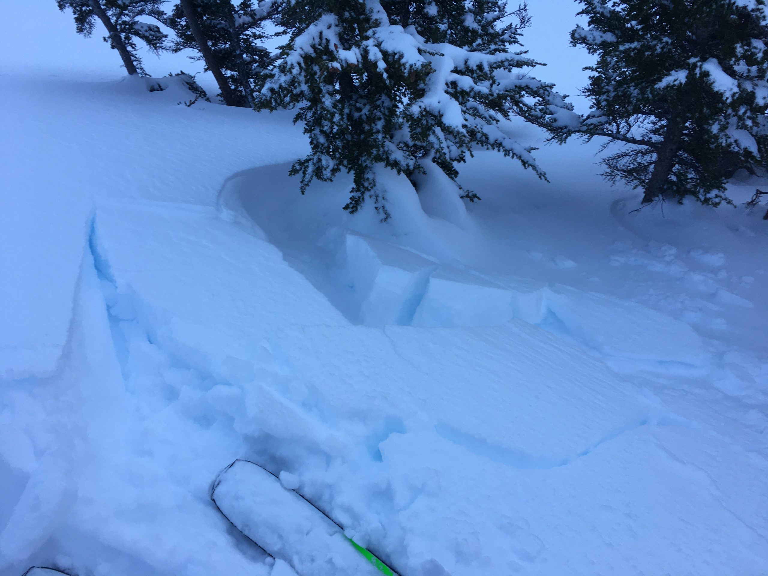
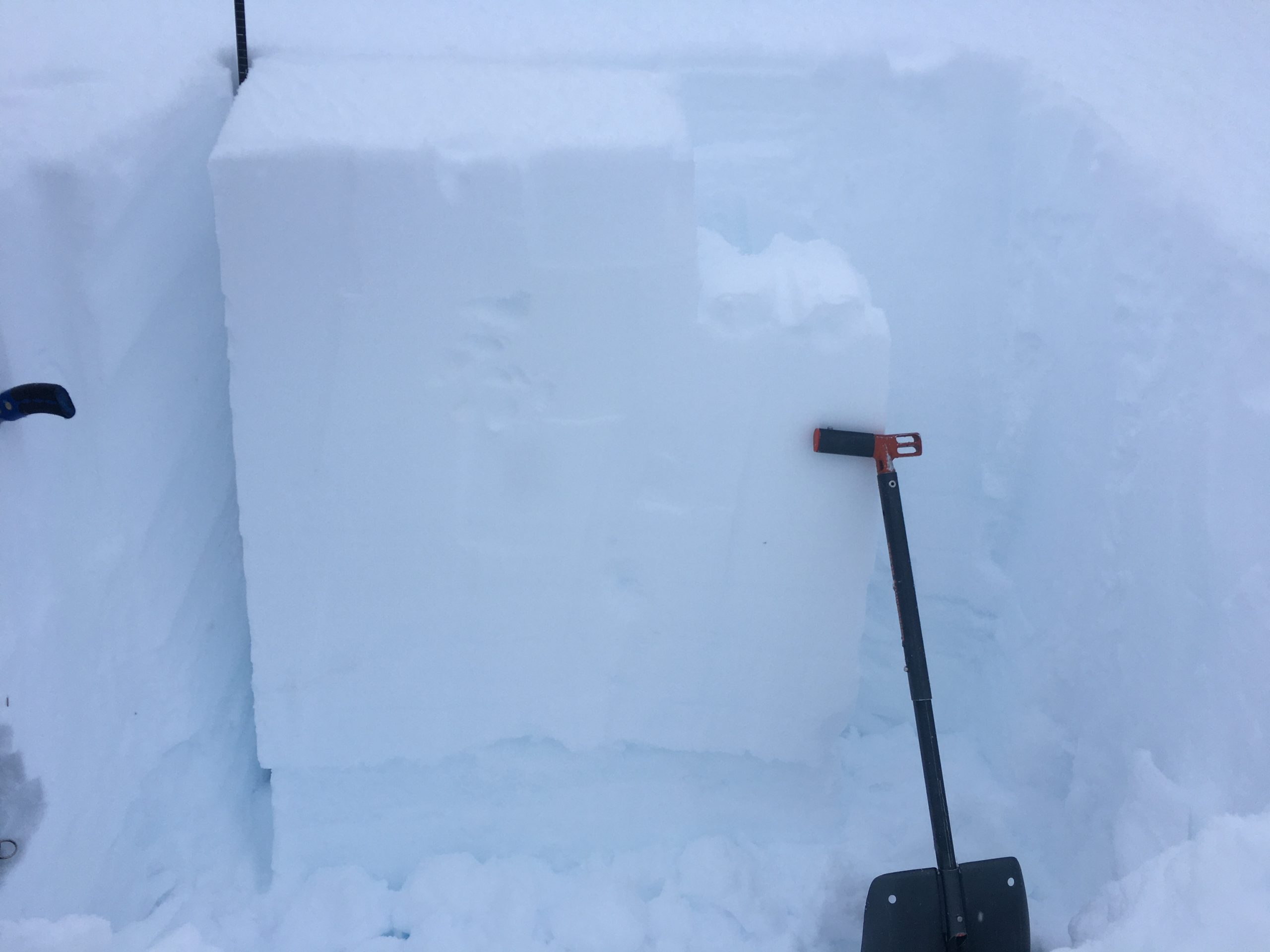
This fresh wind slab broke while stomping on a small test slope. This is a clear sign of unstable snow. 12.28.2020

Cornices:  As always, watch for cornices and give them a wide berth. New snow and wind increase the likelihood that these will break.

Loose snow avalanches (sluffs):  In steep terrain protected from the wind watch for sluffing in the new snow that has not formed a slab. In steep terrain that is below 1000′ where it rained, there is a chance of triggering small wet loose avalanches in the saturated snow.

Avalanche Problem 2
  • Deep Persistent Slabs
    Deep Persistent Slabs
  • Certain
    Very Likely
    Likely
    Possible
    Unlikely
    Likelihood
  • Historic (D4-5)
    Very Large (D3)
    Large (D2)
    Small (D1)
    Size
Deep Persistent Slabs
Deep Persistent Slab avalanches are the release of a thick cohesive layer of hard snow (a slab), when the bond breaks between the slab and an underlying persistent weak layer deep in the snowpack. The most common persistent weak layers involved in deep, persistent slabs are depth hoar or facets surrounding a deeply buried crust. Deep Persistent Slabs are typically hard to trigger, are very destructive and dangerous due to the large mass of snow involved, and can persist for months once developed. They are often triggered from areas where the snow is shallow and weak, and are particularly difficult to forecast for and manage.

Likelihood of Avalanches
Terms such as "unlikely", "likely", and "certain" are used to define the scale, with the chance of triggering or observing avalanches increasing as we move up the scale. For our purposes, "Unlikely" means that few avalanches could be triggered in avalanche terrain and natural avalanches are not expected. "Certain" means that humans will be able to trigger avalanches on many slopes, and natural avalanches are expected.

Size of Avalanches
Avalanche size is defined by the largest potential avalanche, or expected range of sizes related to the problem in question. Assigned size is a qualitative estimate based on the destructive classification system and requires specialists to estimate the harm avalanches may cause to hypothetical objects located in the avalanche track (AAA 2016, CAA 2014). Under this schema, "Small" avalanches are not large enough to bury humans and are relatively harmless unless they carry people over cliffs or through trees or rocks. Moving up the scale, avalanches become "Large" enough to bury, injure, or kill people. "Very Large" avalanches may bury or destroy vehicles or houses, and "Historic" avalanches are massive events capable of altering the landscape.

Signal Word Size (D scale) Simple Descriptor
Small 1 Unlikely to bury a person
Large 2 Can bury a person
Very Large 3 Can destroy a house
Historic 4 & 5 Can destroy part or all of a village
More info at Avalanche.org

A buried rain crust in the middle of the snowpack has recently shown signs of weakening, and it is on our radar as a potential avalanche problem. Recent avalanche mitigation with explosives has produced very large avalanches failing at this layer, initiated around 2500′. This crust has been loaded with 7.4″ SWE (Center Ridge snotel data) since it formed on 12/1, and has recently been developing facets. Be aware that if you are moving into steep terrain between 1300-2500’, you are taking on additional risk that is hard to quantify because of the high uncertainty associated with this layer. Although it is unlikely a person would trigger an avalanche on this layer, it is not impossible. Keep in mind that if this layer does fail, it is capable of producing a large avalanche 3-5’ deep.

In addition to this 12/1 crust/facet situation, the Summit Lake region to the south of our forecast area also has a thinner snowpack with faceted snow at the ground. These layers are both worth keeping in mind before trying to push into bigger terrain.

The 12/1 crust-facet combination has been failing in some stability tests recently. This layer is now buried about a foot deeper than when this photo was taken. ECTP26. 12.26.2020

Weather
Tue, December 29th, 2020

Yesterday: Light snowfall continued through the day yesterday, with the rain level making it up to around 1000′ in the afternoon. Temperatures reached the upper 20’s F at higher elevations, and high 30’s F at low elevations. Easterly ridgetop winds were blowing around 20-25 mph with gusts to 61 mph, until they began to calm down to 10-15 mph in the evening.

Today: Temperatures are expected reach the mid-20’s F at upper elevations, and the high 20’s to low 30’s F at lower elevations, with easterly ridgetop winds blowing at 15-20 mph. There is a chance of light snowfall under mostly cloudy skies, with accumulations around an inch. Rain level is expected to stay around 800 feet.

Tomorrow: There is an increased chance of precipitation tonight, with 3-6″ expected in the mountains near Girdwood and 6-8″ possible in the upper elevations near Turnagain Pass. We should see snow to sea level with this next pulse of moisture. Easterly winds are expected to shift to southerly through the night, with ridgetop speeds of 10-20 mph. Temperatures are expected to get down to the low to mid-20’s F tonight, and the mid-20’s to low 30’s tomorrow.

PRECIPITATION 24-hour data (6am – 6am)

Temp Avg (F) Snow (in) Water (in) Snow Depth (in)
Center Ridge (1880′) 32 0 0 82
Summit Lake (1400′) 30 1 0.1 32
Alyeska Mid (1700′) 31 4 0.3 85

RIDGETOP 24-hour data (6am – 6am)

Temp Avg (F) Wind Dir Wind Avg (mph) Wind Gust (mph)
Sunburst (3812′) 24 ENE 14 42
Seattle Ridge (2400′) 27 SE 9 22
Observations
Recent Observations for Turnagain Pass
Date Region Location
04/23/24 Turnagain Observation: Turnagain Sunny Side
04/21/24 Turnagain Observation: Bertha Creek
04/20/24 Turnagain Avalanche: Spokane Creek
04/16/24 Turnagain Observation: Cornbiscuit
04/15/24 Turnagain Observation: Taylor Pass
04/15/24 Turnagain Observation: Seward Highway – Tern Lake to Portage
04/14/24 Turnagain Observation: Sunburst
04/14/24 Turnagain Observation: Turnagain Pass Snomo
04/13/24 Turnagain Observation: Spokane Creek
04/11/24 Turnagain Observation: Tincan
Riding Areas

The riding areas page has moved. Please click here & update your bookmarks.


Subscribe to Turnagain Pass
Avalanche Forecast by Email

This is a general backcountry avalanche advisory issued for Turnagain Arm with Turnagain Pass as the core advisory area. This advisory does not apply to highways, railroads or operating ski areas.