Turnagain Pass Avalanche Forecast
|
![]() ![]() |
Signal Word | Size (D scale) | Simple Descriptor |
Small | 1 | Unlikely to bury a person |
Large | 2 | Can bury a person |
Very Large | 3 | Can destroy a house |
Historic | 4 & 5 | Can destroy part or all of a village |
Snow started falling yesterday afternoon and the region picked up 4-8″ of low density snow. Wind speeds also increased enough to transport snow at higher elevations in wind exposed terrain. Today expect small tender wind slabs just off of ridgelines and in cross-loaded gullies. The new snow fell covering the Solstice surface hoar. This sparkly snow grain now buried will likely become a layer of concern and will contribute to how touchy the fresh wind slabs are. As you travel today look for cracking, be suspicious of loaded slopes and feel for hard over soft snow. If the slabs are stiff enough to support a person there may be some whumpfing as well. This is a definite a sign of instability. Remember even a small slab can mean trouble in high consequence terrain.
Loose snow avalanches: In steep terrain that is protected from the wind, the new snow will increase the likelihood of sluffing. Observers prior to this quick shot of snow had already reported sluffs growing in size as surface snow became less cohesive with the cold temperatures.
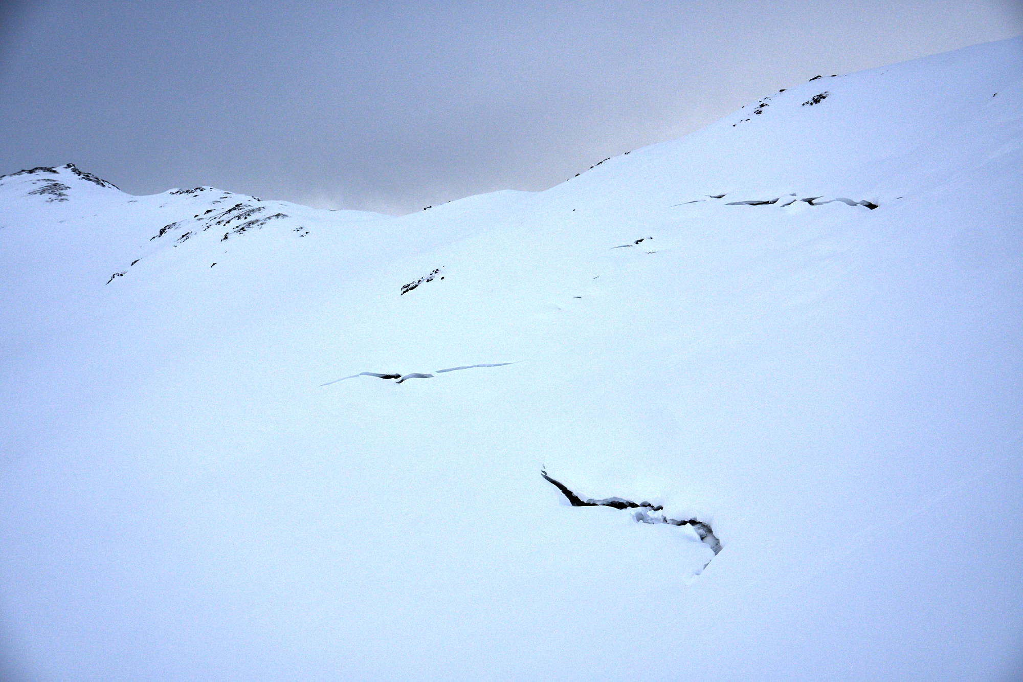
Cornices: An observer yesterday had some good insight into the cornice situation. “The cornices appear to be really precariously bonded. They look as if they formed, then drooped but didn’t release… then a new cornice began to form above the old. Really spooky looking and lots of tracks underneath them. With this wind they will get even worse.” Avoid travel on or underneath cornices. Watch for cornice crevasses and remember cornices can break much farther back than expected.
Signal Word | Size (D scale) | Simple Descriptor |
Small | 1 | Unlikely to bury a person |
Large | 2 | Can bury a person |
Very Large | 3 | Can destroy a house |
Historic | 4 & 5 | Can destroy part or all of a village |
The more folks traveled around the region to this weekend, the more glide cracks were reported. These are starting to open in common areas to travel through. Remember to avoid spending time underneath. Glide avalanches are very unpredictable and can release at anytime.
In the high Alpine, above 3,000′, we have been tracking a weak layer of snow sitting near the base of the snowpack. This weak layer is buried anywhere from 1-6+ feet deep due to the variable wind loading during the December storm cycles. There has been a lingering concern a person could trigger a large avalanche if they hit the wrong spot. Data is pointing to this layer being dormant as this point. However, we will keep it on the radar especially in areas where the overall snowpack is shallower – towards the southern end of Turnagain Pass, in Summit Lake and in the Crow Pass terrain north of Girdwood.
Yesterday: Skies were overcast and became obscured as the storm moved in. Light snow started in the early afternoon and easterly winds picked up mid-morning gusting into the 40s. Temperatures rose from single digits in the morning to 20°Fs by the afternoon. Snow continued overnight and winds decreased in the early morning.
Today: Cloudy skies and light snow showers with 1-5″ of snow forecast. Winds will be mostly light and easterly. Temperatures will be in the high teens to mid 20°Fs today and tonight. Snow showers continue overnight and winds remain light and easterly.
Tomorrow: Cloudy skies and light snow continue. Temperatures stay in the 20°Fs and winds shift to the north and remain light. A white Christmas is in the forecast and the pattern stays active through the week!
PRECIPITATION 24-hour data (6am – 6am)
Temp Avg (F) | Snow (in) | Water (in) | Snow Depth (in) | |
---|---|---|---|---|
Center Ridge (1880′) | 18 | 6 | 0.3 | 29 |
Summit Lake (1400′) | 15 | 0 | 0 | 7 |
Alyeska Mid (1700′) | 17 | 5 | 0.17 | 19 |
RIDGETOP 24-hour data (6am – 6am)
Temp Avg (F) | Wind Dir | Wind Avg (mph) | Wind Gust (mph) | |
---|---|---|---|---|
Sunburst (3812′) | 12 | NE | 13 | 48 |
Seattle Ridge (2400′) | NA* | NA* | NA* | NA* |
*Seattle Ridge was worked on yesterday and started reporting data but unfortunately may be rimed again.
Date | Region | Location | Observer |
---|---|---|---|
01/19/21 | Turnagain | Avalanche: Cornbiscuit | Schauer/ Johnston-Bloom Forecaster |
01/19/21 | Turnagain | Avalanche: Sunburst and Tincan | CNFAIC Staff |
01/19/21 | Turnagain | Avalanche: Seattle Ridge | CNFAIC Staff |
01/19/21 | Turnagain | Avalanche: Tincan 2900′ SW aspect below Hippy Bowl. | Kris Marshall |
01/18/21 | Turnagain | Observation: Turnagain Pass Road Obs. | A Schauer Forecaster |
01/16/21 | Turnagain | Avalanche: Tincan Trees | A Schauer Forecaster |
01/15/21 | Turnagain | Observation: Sunburst | Schauer/ Wunnicke Forecaster |
01/13/21 | Turnagain | Observation: Tincan | Johnston-Bloom / Moderow Forecaster |
01/13/21 | Turnagain | Observation: Center Ridge Meadows | Alaska Avalanche School Rec Level 1 Roberts |
01/12/21 | Turnagain | Avalanche: Seattle Ridge/Center Ridge | A Schauer Forecaster |
Status of riding areas across the Chugach NF is managed by the Glacier and Seward Ranger Districts, not avalanche center staff. Riding area information is posted as a public service to our users and updated based on snow depth and snow density to prevent resource damage at trailhead locations. Riding area questions contact: mailroom_r10_chugach@fs.fed.us
Area | Status | Weather & Riding Conditions |
---|---|---|
Glacier District |
Subscribe to Turnagain Pass
Avalanche Forecast by Email
This is a general backcountry avalanche advisory issued for Turnagain Arm with Turnagain Pass as the core advisory area. This advisory does not apply to highways, railroads or operating ski areas.