Turnagain Pass Avalanche Forecast
|
![]() ![]() |
The avalanche danger is MODERATE above 1000′ today. Light snow on the surface combined with NW outflow winds will form fresh wind slabs up to 1′ deep in upper elevation areas and in areas exposed to gap winds. Human triggered avalanches are possible and natural avalanches are unlikely. Above 3000′ there is a weak layer on the ground that could produce larger avalanches 2-4′ deep. Below 1000′ the avalanche danger is LOW.
Avalanche Education Scholarships: Get your application in TODAY! The Friends of the Chugach Avalanche Center host two scholarships; the deadline is December 1st. Several opportunities are available. See details HERE.
The last known avalanche activity was small natural wind slabs triggered during the last outflow wind event 5 days ago.
Signal Word | Size (D scale) | Simple Descriptor |
Small | 1 | Unlikely to bury a person |
Large | 2 | Can bury a person |
Very Large | 3 | Can destroy a house |
Historic | 4 & 5 | Can destroy part or all of a village |
Another round of NW outflow winds are impacting the forecast area today after a small refresh of 2″ of new snow overnight. This fresh snow combined with the soft surface snow that made it through the last round of winds this past weekend will be enough to create fresh wind slabs today up to 1′ deep. Wind slabs are most likely to form at upper elevations along ridgelines, cross loaded gullies, and convex terrain features. Human triggered avalanches will be possible today and natural avalanches unlikely.
We were pleasantly surprised yesterday that there was plenty of soft surface snow left over from the last round of outflow winds (ob here). It can be hard to tell just by looking at the snow surface where there are stiff wind slabs and where the snow surface is still soft. Stepping out of the skin track to feel the snow surface with your poles or feet is a great way to get a better sense of the surface conditions. Look for stiffer or hollow feeling snow at the surface to identify areas that have been wind loaded. Using small test slopes can be another good way to check whether fresh wind slabs are building up and if they are sensitive to human triggers in the area you want to ski or ride. As always, set yourself up for success by only exposing one member of your party to avalanche terrain at a time and spotting your partners.
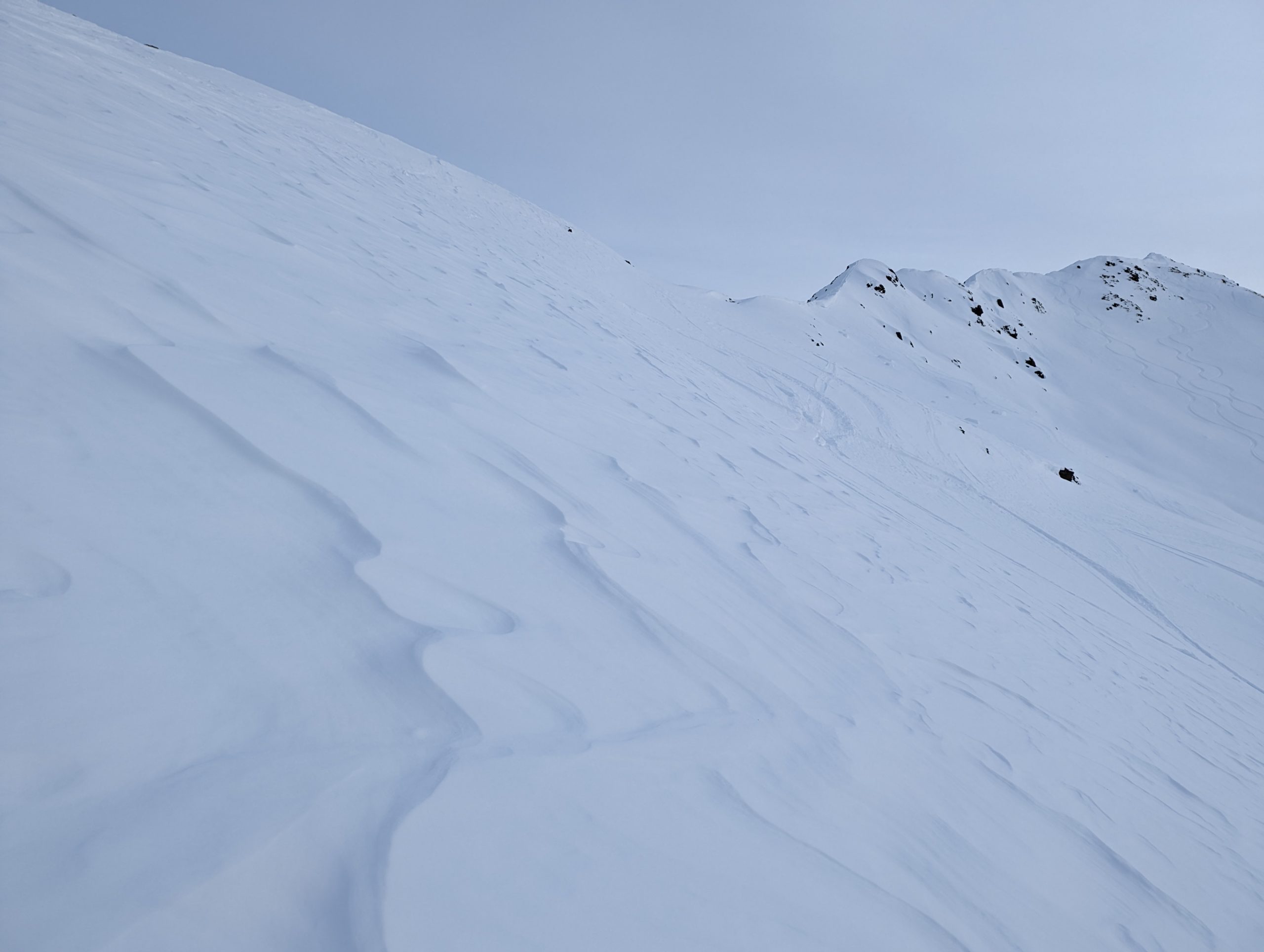
Signs of recent wind transport on the snow surface from Tincan Common. The winds that created this texture occurred last weekend, but similar weather today will move the snow into fresh wind slabs at upper elevations. Photo 11.30.22
Signal Word | Size (D scale) | Simple Descriptor |
Small | 1 | Unlikely to bury a person |
Large | 2 | Can bury a person |
Very Large | 3 | Can destroy a house |
Historic | 4 & 5 | Can destroy part or all of a village |
It has been over 2 weeks since the last known avalanches occurred on the layer of facets on the ground. However, we have not had a lot of snowfall to put stress on that weak layer in the past 2 weeks. At upper elevations (above 3000′) the snowpack remains thin in many areas and the facets on the ground appear to exist across the forecast area. It is tempting to disregard this weak layer since it has been so long since we have seen avalanches on it, but it is still possible to trigger a large avalanche on this layer at higher elevations. It is common for persistent weak layers like this to lay dormant for long periods and re-activate with the onset of significant new snowfall or rapid wind loading. Avalanches on this layer could be 1-3′ deep and would have high consequences if a person were involved.
Comparison of snowpack structure from upper elevations on Tincan. The weak layer exists in both locations but is better preserved and drier on the N aspect at higher elevation. Photo 11.30.22
Yesterday: Clouds moved into the area during the daylight hours yesterday and there was a strong temperature inversion, with temperatures around 20 F at upper elevations and in the single digits at lower elevations. Winds were light during the day, then shifted to NW around midnight and increased in speed slightly with gusts up to 20 mph. We received about 2″ of fresh snow overnight across the region.
Today: Winds are expected to remain elevated through this afternoon with averages of 10-20 mph and gusts up to 30-40 mph. The winds will be stronger at higher elevations and along Turnagain Arm and other areas where gaps in the terrain allow outflow winds to flow toward the coast. Skies should clear up during the day today. Temperatures should remain in the teens to single digits.
Tomorrow: The outflow winds should start to back off overnight tonight and remain light on Friday. Temperatures will increase slightly with another inversion possibly setting up over the weekend. No new snowfall is expected through the weekend. Cloud cover should be mostly to partly sunny for the next few days.
PRECIPITATION 24-hour data (6am – 6am)
Temp Avg (F) | Snow (in) | Water (in) | Snow Depth (in) | |
---|---|---|---|---|
Center Ridge (1880′) | 18 | 2 | 0.1 | 25 |
Summit Lake (1400′) | 11 | 3 | 0.2 | 16 |
Alyeska Mid (1700′) | 17 | 2.5 | 0.14 | 20 |
Bear Valley (Portage) (132′) | 12 | 2 | 0.11 | – |
RIDGETOP 24-hour data (6am – 6am)
Temp Avg (F) | Wind Dir | Wind Avg (mph) | Wind Gust (mph) | |
---|---|---|---|---|
Sunburst (3812′) | 19 | WNW | 5 | 21 |
Seattle Ridge (2400′) | 18 | NNW | 5 | 21 |
Date | Region | Location | Observer |
---|---|---|---|
01/29/23 | Turnagain | Observation: Tincan Backdoor | AAS-Level 1 1/27-1/30 |
01/28/23 | Turnagain | Observation: Sunburst | Brooke Edwards |
01/28/23 | Turnagain | Avalanche: Seattle Ridge | W Wagner |
01/28/23 | Turnagain | Observation: Tincan Common | Tony Naciuk |
01/27/23 | Turnagain | Observation: Sunburst | John Sykes |
01/27/23 | Turnagain | Avalanche: Lynx Creek | Megan Guinn / W Wagner |
01/25/23 | Turnagain | Observation: Cornbiscuit | John Sykes Forecaster |
01/22/23 | Turnagain | Avalanche: Tincan | Schauer/ Guinn |
01/21/23 | Turnagain | Avalanche: Seattle Ridge | Elias Holt |
01/21/23 | Turnagain | Avalanche: Lynx drainage – avalanche | CNFAIC Staff |
Status of riding areas across the Chugach NF is managed by the Glacier and Seward Ranger Districts, not avalanche center staff. Riding area information is posted as a public service to our users and updated based on snow depth and snow density to prevent resource damage at trailhead locations. Riding area questions contact: mailroom_r10_chugach@fs.fed.us
Area | Status | Weather & Riding Conditions |
---|---|---|
Glacier District |
Subscribe to Turnagain Pass
Avalanche Forecast by Email
This is a general backcountry avalanche advisory issued for Turnagain Arm with Turnagain Pass as the core advisory area. This advisory does not apply to highways, railroads or operating ski areas.