Temperature inversion was pretty noticeable, with cold temps down at the road level and much warmer up in the alpine. High clouds building throughout the day. Calm to light winds.
Observation: Turnagain
Location: Tincan
Skinned up the normal uptrack for Tincan Common the then continued out the ridge to 3600′.
Some new surface hoar had grown during the clear skies and we could see it on the surface from the road level up to about 2000'. The wind effect started to be much more noticeable above 2000' and we did not see surface hoar on the surface. The surface conditions were variable in wind effected areas, ranging from very low density snow with just a slight wind sculpting to areas that were blown back down to the old melt freeze crust. It was hard to tell where it was soft or firm just based on the surface texture.
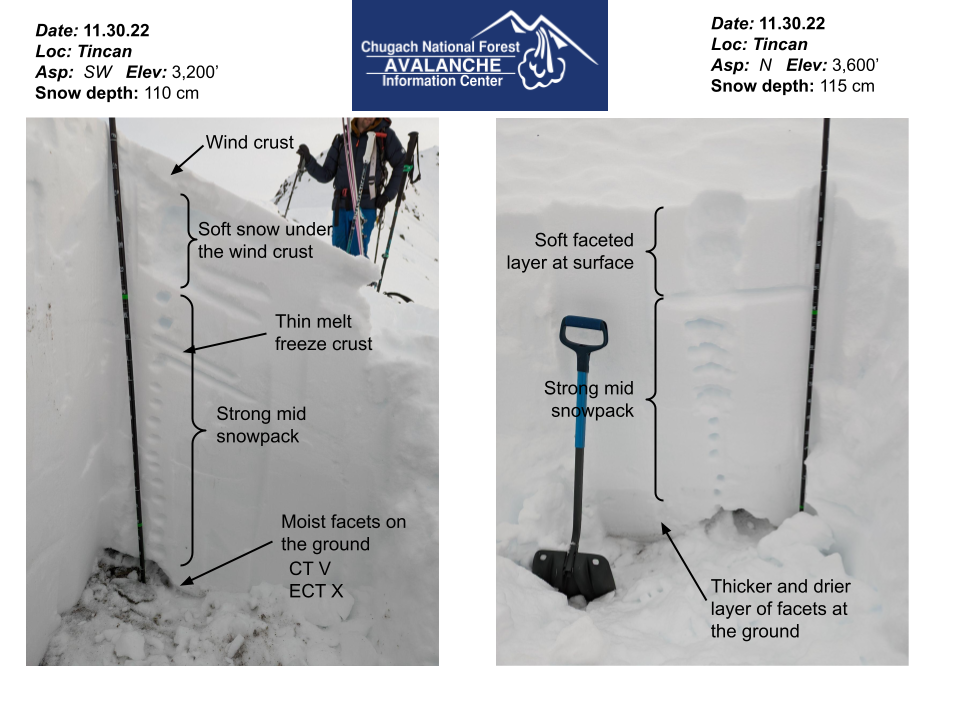
See photos for snowpack comparison. Our first pit at around 3200' on SW aspect had a 5 cm (2.5") wind crust on the surface with soft snow underneath for the first 20 cm (8"). Below this the snowpack was pretty strong with a 1cm (.5") melt freeze crust about 35 cm (14") down. At the ground we found a layer of moist 2mm facets. The facets failed on isolation in our compression test. In the extended column test we had no results on this layer.
At 3600' on a N aspect we dug another pit to check the overall structure on northern aspects. The structure was largely similar, but there was no wind crust on the surface or melt freeze crust mid-pack. The facet layer at the ground was thicker here and felt drier (could not form a snowball). It has been a while since our snowpack saw a significant load, and we have not observed any avalanche activity on this layer in over 2 weeks. However, with our thin early season snowpack this layer still seems close enough to the surface that it could be an issue if we get a big loading event. Hopefully we will find out next week!

Snowpack comparison from upper elevation on Tincan on N and SW aspects.

Larger sastrugi indicating a thicker wind crust on the surface.

Surface hoar growing on top of a layer of well developed surface facets sitting on top of a crust at lower elevations. Potentially our future weak layer for treeline elevations.

PXL_20221130_204757936