Turnagain Pass Avalanche Forecast
|
![]() ![]() |
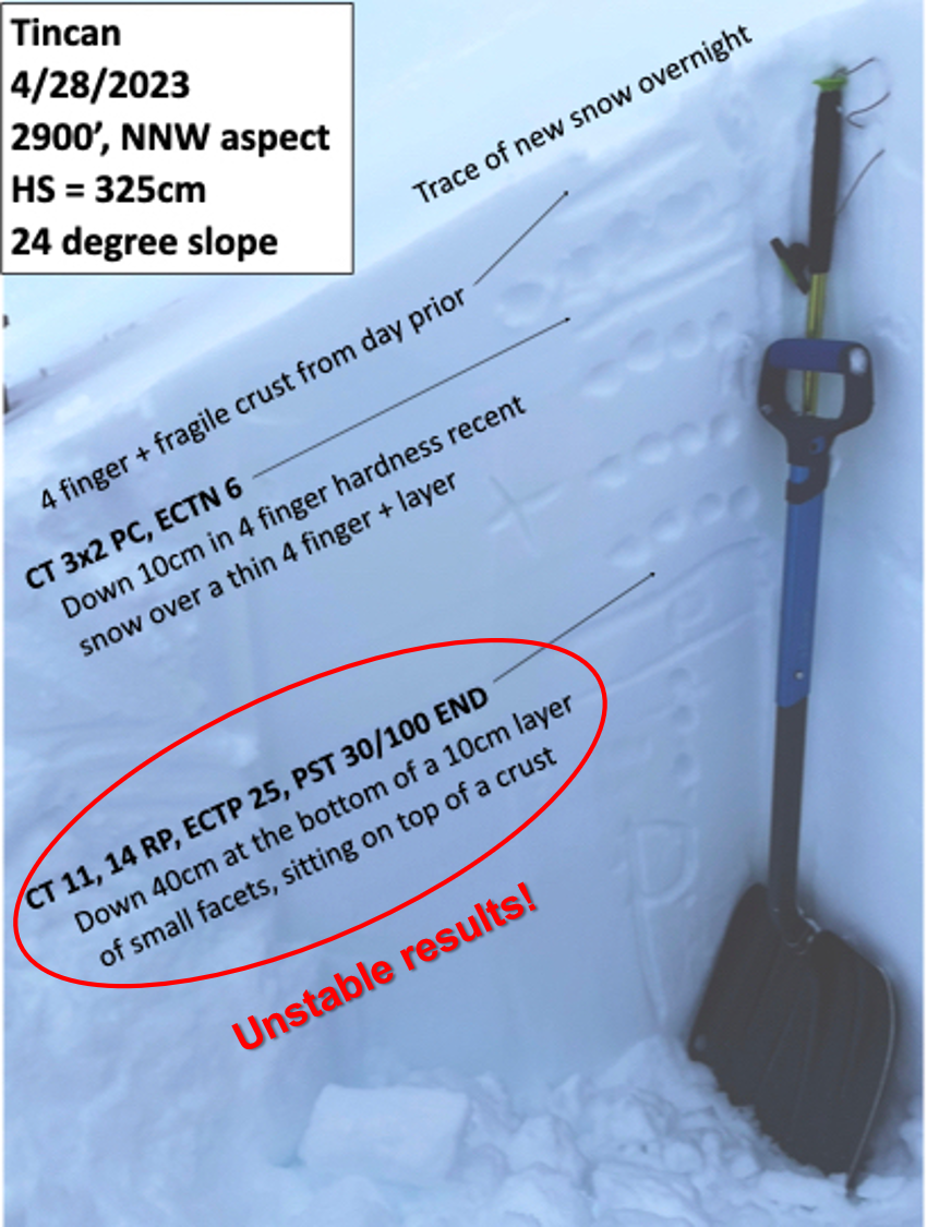
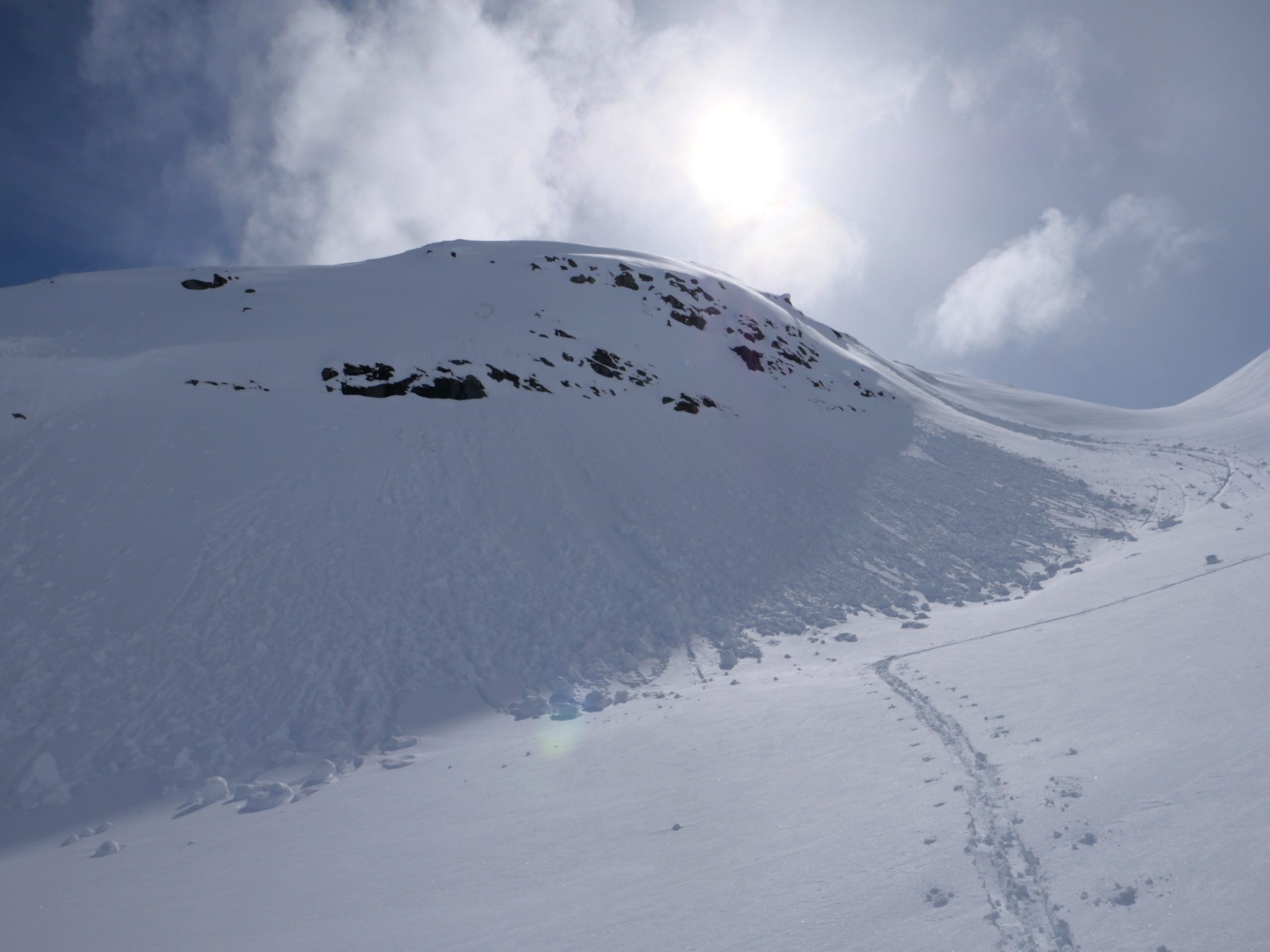
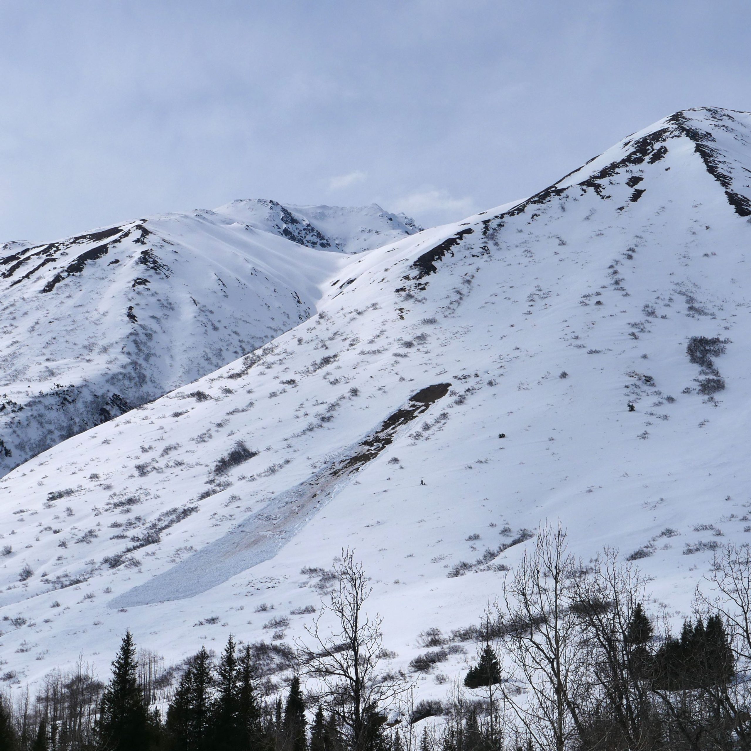
The avalanche danger is MODERATE above 1000′. It is possible a person will be able to trigger an avalanche up to 1-2′ deep where new snow from the past week is sitting on top of weaker facets, especially where it has been blown into a stiffer wind slab. It will also be possible to trigger wet loose avalanches as temperatures rise later in the day. The danger is LOW below 1000′.
PORTAGE VALLEY: Avalanches failing at mid and upper elevations often impact the low-elevation hiking trails in the spring. Be aware of this overhead hazard even if you are not trying to get up high into the mountains.
End of season operations: We will issue our final advisory of the season tomorrow (4/30). We will continue to issue periodic snowpack updates for the following week as active weather continues, and will post our final springtime tips at the end of the week.
We triggered two small wind slab avalanches with ski cuts in steep north-facing terrain near Taylor Pass yesterday. These were only around 6″ deep and 10-20′ wide, but they ran for a few hundred vertical feet.
Debris from a skier-triggered wind slab (left) and a natural dry loose avalanche (right) near Taylor Pass yesterday. 04.28.2023
Signal Word | Size (D scale) | Simple Descriptor |
Small | 1 | Unlikely to bury a person |
Large | 2 | Can bury a person |
Very Large | 3 | Can destroy a house |
Historic | 4 & 5 | Can destroy part or all of a village |
The main concern for today will be triggering an avalanche in steep, upper elevation terrain where snow from the past week is sitting on top of weaker facets. We have seen reactive pit results on this layer over the past few days (details here and here), and we triggered some small avalanches with ski cuts in steep, wind-loaded terrain near Taylor Pass yesterday (details here). These avalanches could be anywhere from 6″ to 2′ deep, and they are becoming less likely with more time to settle out. With limited observations over the past week, there is some uncertainty as to just how widespread this problem is. That means safe travel today will require constant assessment before committing to steep terrain. Be on the lookout for warning signs like shooting cracks and collapses, and seek out feedback from the snowpack as you travel. This can be as simple as some quick hand pits to see how well the newer snow is bonding to the older snow, or using smaller slopes to test the surface snow. If you have any doubt about the likelihood of triggering an avalanche, you can avoid the problem by sticking to lower angle slopes.
We’ve seen multiple snowpits with unstable results on Tincan this week. We haven’t yet seen any avalanches on this layer, but there has been very little traffic since it was buried. Photo: Andy Moderow. 04.28.2023
Signal Word | Size (D scale) | Simple Descriptor |
Small | 1 | Unlikely to bury a person |
Large | 2 | Can bury a person |
Very Large | 3 | Can destroy a house |
Historic | 4 & 5 | Can destroy part or all of a village |
In addition to the dry snow problems mentioned above, we will also be on the lookout for loose wet avalanches as things heat up today. The likelihood of these wet snow avalanches will depend on how quickly the clouds move in this afternoon. Pay attention to changing conditions and increasing danger as the snow surface heats up later in the day. If you start to notice wet and sloppy snow near the surface it is time to move to shady aspects or head back to the parking lot. There is a small chance that a wet snow avalanche failing near the surface may pull out a bigger slab on its way down.
Glide Avalanches: We are seeing more and more glide activity as the snowpack continues to heat up. The timing on these is impossible to predict, and they can be very large because they involve the entire snowpack. Be sure to avoid spending time below glide cracks, as they can release unexpectedly.
Rollerballs like this are often a precursor to wet snow avalanches. If you start to see these as things heat up through the day, it is time to move into shady slopes or head back down for the day. 04.28.2023
We have seen quite a few glide avalanches releasing over the past week, and similar activity is possible today. This glide avalanche on the south end of Seattle Ridge occurred sometime Thursday or Friday. 04.28.2023
We are still tracking the weak layer of facets that was buried in the middle of March and was likely the culprit for a large skier-triggered avalanche near Girdwood 10 days ago (details in this near-miss report). The chances of triggering a very large avalanche on this layer are small, but the consequences are severe. These deep slab avalanches are very difficult to predict, and often catch people by surprise. Consider the consequence of triggering one of these large avalanches before moving into steep terrain. With this extra layer of uncertainty, we are avoiding some of the bigger objectives we might otherwise be considering this time of year. If you want to avoid the problem entirely, you can simply stay off of steeper slopes.
Yesterday: Skies were partly to mostly cloudy with high temperatures reaching the low 40’s F at lower elevations and the mid to upper 20’s F at higher elevations. The day started with moderate easterly winds at 15-20 mph but those winds quickly backed down to 5-10 mph with gusts of 10-20 mph for most of the day. We did not see any precipitation in the past 24 hours.
Today: Skies should start off mostly clear with increasing clouds through the day. High temperatures are expected to get back into the low 40’s F at lower elevations and into the mid 30’s F at upper elevations. Winds should be light out of the north to northwest, and we are not expecting any precipitation today.
Tomorrow: We are looking at a return to more active weather starting later tomorrow afternoon, with easterly winds increasing through the day and getting up to 25 mph with gusts to 40 mph before sunset. Chances of precipitation increase later in the day, but we will most likely only see a trace of snow before sunset. Skies will start off partly cloudy with increasing clouds through the day. Look for continued stormy weather into the first part of next week.
PRECIPITATION 24-hour data (6am – 6am)
Temp Avg (F) | Snow (in) | Water (in) | Snow Depth (in) | |
---|---|---|---|---|
Center Ridge (1880′) | 36 | 0 | 0 | 83 |
Summit Lake (1400′) | 37 | 0 | 0 | 35 |
Alyeska Mid (1700′) | 35 | 0 | 0 | 75 |
Bear Valley – Portage (132′) | 36 | 0 | 0 | – |
RIDGETOP 24-hour data (6am – 6am)
Temp Avg (F) | Wind Dir | Wind Avg (mph) | Wind Gust (mph) | |
---|---|---|---|---|
Sunburst (3812′) | 23 | ENE | 8 | 16 |
Seattle Ridge (2400′) | 28 | SE | 8 | 11 |
Date | Region | Location | Observer |
---|---|---|---|
05/22/23 | Turnagain | Avalanche: Tincan | Nick D'Alessio |
05/12/23 | Turnagain | Avalanche: Tincan, Sunburst, Magnum, Cornbiscuit | Heather Thamm |
05/07/23 | Turnagain | Observation: Tincan – Bear Tracks | CNFAIC Staff |
05/05/23 | Turnagain | Observation: Seattle Ridge | AS/ WW Forecaster |
05/02/23 | Turnagain | Observation: Cornbiscuit | Schauer/ Sturgess Forecaster |
05/02/23 | Turnagain | Observation: Seward Hwy Turnagain Pass | Joel Curtis |
04/30/23 | Turnagain | Observation: Magnum | Ayla, Kit Crosby, Barton |
04/29/23 | Turnagain | Observation: Tincan | John Sykes |
04/28/23 | Turnagain | Avalanche: Taylor Pass/Pastoral | Schauer/ Creighton Forecaster |
04/28/23 | Turnagain | Avalanche: Tincan | Andy Moderow |
Status of riding areas across the Chugach NF is managed by the Glacier and Seward Ranger Districts, not avalanche center staff. Riding area information is posted as a public service to our users and updated based on snow depth and snow density to prevent resource damage at trailhead locations. Riding area questions contact: mailroom_r10_chugach@fs.fed.us
Area | Status | Weather & Riding Conditions |
---|---|---|
Glacier District |
Subscribe to Turnagain Pass
Avalanche Forecast by Email
This is a general backcountry avalanche advisory issued for Turnagain Arm with Turnagain Pass as the core advisory area. This advisory does not apply to highways, railroads or operating ski areas.